694:"}},"text\/plain":{"en":{"":"coordinates of the point of view"}}},"{\"value\":{\"latitude\":51.53336,\"longitude\":0.0537,\"altitude\":null,\"precision\":1.0e-5,\"globe\":\"http:\\\/\\\/www.wikidata.org\\\/entity\\\/Q2\"},\"type\":\"globecoordinate\"}":{"text\/html":{"en":{"P1259":"51\u00b032'0.10"N, 0\u00b03'13.32"E"}},"text\/plain":{"en":{"P1259":"51\u00b032'0.10\"N, 0\u00b03'13.32\"E"}}},"{\"value\":{\"entity-type\":\"property\",\"numeric-id\":7787,\"id\":\"P7787\"},\"type\":\"wikibase-entityid\"}":{"text\/html":{"en":{"":"
919:"}},"text\/plain":{"en":{"":"coordinates of depicted place"}}},"{\"value\":{\"latitude\":51.53279,\"longitude\":0.0556,\"altitude\":null,\"precision\":1.0e-5,\"globe\":\"http:\\\/\\\/www.wikidata.org\\\/entity\\\/Q2\"},\"type\":\"globecoordinate\"}":{"text\/html":{"en":{"P9149":"51\u00b031'58.04"N, 0\u00b03'20.16"E"}},"text\/plain":{"en":{"P9149":"51\u00b031'58.04\"N, 0\u00b03'20.16\"E"}}},"{\"value\":{\"entity-type\":\"property\",\"numeric-id\":7787,\"id\":\"P7787\"},\"type\":\"wikibase-entityid\"}":{"text\/html":{"en":{"":"
881:"}},"text\/plain":{"en":{"":"inception"}}},"{\"value\":{\"time\":\"+1981-01-01T00:00:00Z\",\"timezone\":0,\"before\":0,\"after\":0,\"precision\":9,\"calendarmodel\":\"http:\\\/\\\/www.wikidata.org\\\/entity\\\/Q1985727\"},\"type\":\"time\"}":{"text\/html":{"en":{"P571":"1981"}},"text\/plain":{"en":{"P571":"1981"}}}}": -->
758:
296:
246:
288:
238:
915:
260:
331:
369:
43:
374:
87:
507:"}},"text\/plain":{"en":{"P2699":"https:\/\/www.geograph.org.uk\/profile\/17944"}}},"{\"value\":{\"entity-type\":\"property\",\"numeric-id\":3831,\"id\":\"P3831\"},\"type\":\"wikibase-entityid\"}":{"text\/html":{"en":{"":"
782:"}},"text\/plain":{"en":{"P973":"https:\/\/www.geograph.org.uk\/photo\/575134"}}},"{\"value\":{\"entity-type\":\"property\",\"numeric-id\":7384,\"id\":\"P7384\"},\"type\":\"wikibase-entityid\"}":{"text\/html":{"en":{"":"
519:"}},"text\/plain":{"en":{"":"author name string"}}},"{\"value\":\"David Nicholls\",\"type\":\"string\"}":{"text\/html":{"en":{"P2093":"David Nicholls"}},"text\/plain":{"en":{"P2093":"David Nicholls"}}}}": -->
766:"}},"text\/plain":{"en":{"P7482":"file available on the internet"}}},"{\"value\":{\"entity-type\":\"property\",\"numeric-id\":137,\"id\":\"P137\"},\"type\":\"wikibase-entityid\"}":{"text\/html":{"en":{"":"
511:"}},"text\/plain":{"en":{"":"object of statement has role"}}},"{\"value\":{\"entity-type\":\"item\",\"numeric-id\":33231,\"id\":\"Q33231\"},\"type\":\"wikibase-entityid\"}":{"text\/html":{"en":{"P3831":"
774:"}},"text\/plain":{"en":{"P137":"Geograph Britain and Ireland"}}},"{\"value\":{\"entity-type\":\"property\",\"numeric-id\":973,\"id\":\"P973\"},\"type\":\"wikibase-entityid\"}":{"text\/html":{"en":{"":"
650:"}},"text\/plain":{"en":{"":"copyright license"}}},"{\"value\":{\"entity-type\":\"item\",\"numeric-id\":19068220,\"id\":\"Q19068220\"},\"type\":\"wikibase-entityid\"}":{"text\/html":{"en":{"P275":"
606:"}},"text\/plain":{"en":{"":"copyright status"}}},"{\"value\":{\"entity-type\":\"item\",\"numeric-id\":50423863,\"id\":\"Q50423863\"},\"type\":\"wikibase-entityid\"}":{"text\/html":{"en":{"P6216":"
762:"}},"text\/plain":{"en":{"":"source of file"}}},"{\"value\":{\"entity-type\":\"item\",\"numeric-id\":74228490,\"id\":\"Q74228490\"},\"type\":\"wikibase-entityid\"}":{"text\/html":{"en":{"P7482":"
515:"}},"text\/plain":{"en":{"P3831":"photographer"}}},"{\"value\":{\"entity-type\":\"property\",\"numeric-id\":2093,\"id\":\"P2093\"},\"type\":\"wikibase-entityid\"}":{"text\/html":{"en":{"":"
923:"}},"text\/plain":{"en":{"":"heading"}}},"{\"value\":{\"amount\":\"+112\",\"unit\":\"http:\\\/\\\/www.wikidata.org\\\/entity\\\/Q28390\"},\"type\":\"quantity\"}":{"text\/html":{"en":{"P7787":"112
770:"}},"text\/plain":{"en":{"":"operator"}}},"{\"value\":{\"entity-type\":\"item\",\"numeric-id\":1503119,\"id\":\"Q1503119\"},\"type\":\"wikibase-entityid\"}":{"text\/html":{"en":{"P137":"
698:"}},"text\/plain":{"en":{"":"heading"}}},"{\"value\":{\"amount\":\"+112\",\"unit\":\"http:\\\/\\\/www.wikidata.org\\\/entity\\\/Q28390\"},\"type\":\"quantity\"}":{"text\/html":{"en":{"P7787":"112
499:"}},"text\/plain":{"en":{"":"creator"}}},"{\"value\":{\"entity-type\":\"property\",\"numeric-id\":2699,\"id\":\"P2699\"},\"type\":\"wikibase-entityid\"}":{"text\/html":{"en":{"":"
602:
877:
786:"}},"text\/plain":{"en":{"":"geograph.org.uk image ID"}}},"{\"value\":\"575134\",\"type\":\"string\"}":{"text\/html":{"en":{"P7384":"
229:
421:– You must give appropriate credit, provide a link to the license, and indicate if changes were made. You may do so in any reasonable manner, but not in any way that suggests the licensor endorses you or your use.
293:
243:
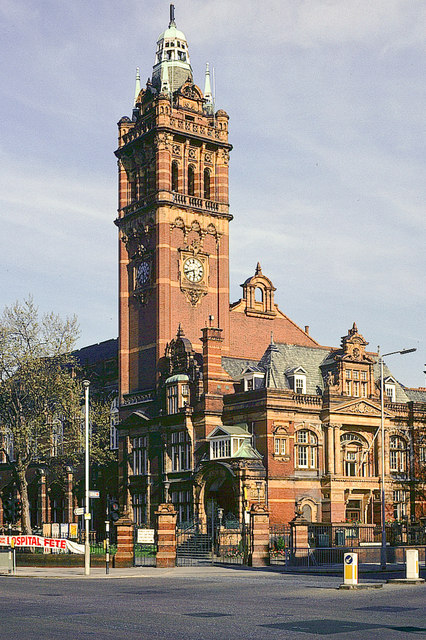
1042:== {{int:filedesc}} == {{Information |description={{en|1=East Ham Town Hall Built 1901-14, by Cheers and Smith}} |date=1981 |source=From |author=[http://www.geograph.org.uk/profile/17944 David Nich
1066:
53:
47:
787:
763:
651:
607:
98:
771:
66:
512:
920:
916:
783:
759:
695:
691:
603:
516:
508:
500:
504:
878:
779:
775:
767:
647:
496:
1099:
1035:
654:"}},"text\/plain":{"en":{"P275":"Creative Commons Attribution-ShareAlike 2.0 Generic"}}}}": -->
813:
677:
633:
303:
253:
1071:
833:
338:
1172:
This file contains additional information, probably added from the digital camera or scanner used to create or digitize it.
428:
575:
961:
934:
856:
797:
736:
709:
617:
583:
568:
553:
888:
841:
826:
661:
526:
485:
1024:
1019:
57:
42:
1215:
384:
1200:
1076:
1175:
If the file has been modified from its original state, some details may not fully reflect the modified file.
427:– If you remix, transform, or build upon the material, you must distribute your contributions under the
345:
on the
Geograph website for the photographer's contact details. The copyright on this image is owned by
1056:
610:"}},"text\/plain":{"en":{"P6216":"copyrighted"}}}}": -->
927:"}},"text\/plain":{"en":{"P7787":"112 degree"}}}}": -->
702:"}},"text\/plain":{"en":{"P7787":"112 degree"}}}}": -->
106:
790:"}},"text\/plain":{"en":{"P7384":"575134"}}}}": -->
198:
560:
863:
848:
381:
182:
8:
325:
309:
259:
350:
93:
475:
1081:
1149:
1119:
171:
161:
944:
898:
807:
719:
671:
627:
536:
330:
342:
1061:
992:
Click on a date/time to view the file as it appeared at that time.
1067:
Grade I and II* listed buildings in the London
Borough of Newham
295:
245:
280:
51° 31′ 58″ N, 0° 03′ 20″ E
230:
51° 32′ 00″ N, 0° 03′ 13″ E
81:
469:
Add a one-line explanation of what this file represents
1159:
1139:
1129:
1109:
1050:
141:
East Ham Town Hall Built 1901-14, by Cheers and Smith
1090:
990:
105:
Commons is a freely licensed media file repository.
678:
Creative
Commons Attribution-ShareAlike 2.0 Generic
652:
Creative
Commons Attribution-ShareAlike 2.0 Generic
150:
131:East Ham Town Hall - geograph.org.uk - 575134.jpg
71:(426 × 640 pixels, file size: 151 KB, MIME type:
438:https://creativecommons.org/licenses/by-sa/2.0
86:
505:https:\/\/www.geograph.org.uk\/profile\/17944
444:Creative Commons Attribution-Share Alike 2.0
362:
146:
128:
780:https:\/\/www.geograph.org.uk\/photo\/575134
167:
156:
14:
924:
699:
404:– to copy, distribute and transmit the work
1092:The following other wikis use this file:
561:https://www.geograph.org.uk/profile/17944
849:https://www.geograph.org.uk/photo/575134
1072:List of city and town halls in England
302:View this and other nearby images on:
252:View this and other nearby images on:
1052:The following 6 pages use this file:
205:
117:
349:and is licensed for reuse under the
270:
220:
983:
385:Attribution-Share Alike 2.0 Generic
373:
368:
353:Attribution-ShareAlike 2.0 license.
13:
1170:
474:
468:
359:
336:
135:
118:
64:
1233:
1177:
473:
710:coordinates of the point of view
692:coordinates of the point of view
459:
415:Under the following conditions:
380:This file is licensed under the
372:
367:
361:
329:
308:
294:
286:
258:
244:
236:
85:
31:
21:
456:
136:
1087:
987:
814:file available on the internet
764:file available on the internet
455:
337:This image was taken from the
26:
1:
1201:Adobe Photoshop CS2 Macintosh
1077:Newham London Borough Council
935:coordinates of depicted place
917:coordinates of depicted place
36:
1047:
834:Geograph Britain and Ireland
772:Geograph Britain and Ireland
569:object of statement has role
509:object of statement has role
481:Items portrayed in this file
321:
285:
235:
7:
1167:
211:David Nicholls /
192:David Nicholls /
10:
1238:
1156:Usage on www.wikidata.org
1146:Usage on uk.wikipedia.org
1136:Usage on sv.wikipedia.org
1126:Usage on nl.wikipedia.org
1116:Usage on ko.wikipedia.org
1106:Usage on es.wikipedia.org
1096:Usage on ar.wikipedia.org
1057:County Borough of East Ham
950:51°31'58.04"N, 0°3'20.16"E
429:same or compatible license
125:
120:
1207:File change date and time
984:
725:51°32'0.10"N, 0°3'13.32"E
16:
857:geograph.org.uk image ID
784:geograph.org.uk image ID
458:
395:
92:This is a file from the
41:
1041:
183:required by the license
149:
96:. Information from its
1020:09:57, 6 February 2011
343:this photograph's page
314:51.532790; 0.055600
264:51.533360; 0.053700
99:description page there
46:Size of this preview:
1210:20:29, 4 October 2007
1181:Horizontal resolution
1100:هام الشرقية (إنجلترا)
1189:Vertical resolution
410:– to adapt the work
52:Other resolutions:
584:author name string
517:author name string
213:East Ham Town Hall
194:East Ham Town Hall
1225:
1224:
1088:Global file usage
1045:
926:
701:
662:copyright license
648:copyright license
467:
358:
357:
341:collection. See
319:
318:
269:
268:
218:
217:
186:
114:
113:
94:Wikimedia Commons
32:Global file usage
1229:
1178:
1082:Newham Town Hall
1032:
994:
972:
971:
966:
866:
861:
851:
846:
842:described at URL
836:
831:
776:described at URL
747:
746:
741:
618:copyright status
604:copyright status
591:
588:
578:
573:
563:
558:
465:
451:
448:
445:
442:
439:
431:as the original.
393:
382:Creative Commons
376:
375:
371:
370:
365:
364:
351:Creative Commons
339:Geograph project
333:
326:
315:
312:
298:
297:
291:
290:
289:
283:
282:
271:
265:
262:
248:
247:
241:
240:
239:
233:
232:
221:
180:
152:
140:
132:
126:
110:
89:
88:
82:
76:
74:
61:
58:426 × 640 pixels
54:160 × 240 pixels
48:399 × 599 pixels
1237:
1236:
1232:
1231:
1230:
1228:
1227:
1226:
1166:
1086:
1046:
1038:
1030:
986:
985:
982:
981:
980:
979:
978:
977:
976:
975:
974:
973:
969:
967:
964:
955:
954:
953:
951:
941:
940:
939:
937:
914:
913:
912:
911:
910:
909:
908:
907:
905:
895:
894:
893:
891:
876:
875:
874:
873:
872:
871:
870:
869:
868:
867:
862:
859:
853:
852:
847:
844:
838:
837:
832:
829:
820:
819:
818:
816:
804:
803:
802:
800:
757:
756:
755:
754:
753:
752:
751:
750:
749:
748:
744:
742:
739:
730:
729:
728:
726:
716:
715:
714:
712:
689:
688:
687:
686:
685:
684:
683:
682:
680:
668:
667:
666:
664:
645:
644:
643:
642:
641:
640:
639:
638:
636:
624:
623:
622:
620:
601:
600:
599:
598:
597:
596:
595:
594:
593:
592:
589:
586:
580:
579:
574:
571:
565:
564:
559:
556:
547:
546:
545:
543:
533:
532:
531:
529:
494:
493:
492:
491:
490:
488:
472:
471:
470:
453:
452:
449:
446:
443:
440:
437:
436:
394:
391:
388:
377:
354:
324:
313:
287:
278:
277:
274:Object location
263:
237:
228:
227:
224:Camera location
219:
208:
201:
189:
162:geograph.org.uk
142:
130:
123:
116:
115:
104:
103:
102:is shown below.
78:
72:
70:
63:
62:
51:
12:
11:
5:
1235:
1223:
1222:
1219:
1212:
1211:
1208:
1204:
1203:
1198:
1194:
1193:
1190:
1186:
1185:
1182:
1169:
1165:
1164:
1163:
1162:
1154:
1153:
1152:
1144:
1143:
1142:
1134:
1133:
1132:
1124:
1123:
1122:
1114:
1113:
1112:
1104:
1103:
1102:
1089:
1085:
1084:
1079:
1074:
1069:
1064:
1059:
1049:
1044:
1043:
1040:
1036:
1033:
1027:
1022:
1017:
1013:
1012:
1009:
1006:
1003:
1000:
997:
989:
960:
959:
958:
957:
956:
952:
949:
947:
946:
945:
943:
942:
938:
933:
931:
930:
929:
928:
922:
918:
906:
903:
901:
900:
899:
897:
896:
892:
887:
885:
884:
883:
882:
880:
855:
854:
840:
839:
825:
824:
823:
822:
821:
817:
812:
810:
809:
808:
806:
805:
801:
798:source of file
796:
794:
793:
792:
791:
789:
785:
781:
777:
773:
769:
765:
761:
760:source of file
735:
734:
733:
732:
731:
727:
724:
722:
721:
720:
718:
717:
713:
708:
706:
705:
704:
703:
697:
693:
681:
676:
674:
673:
672:
670:
669:
665:
660:
658:
657:
656:
655:
653:
649:
637:
632:
630:
629:
628:
626:
625:
621:
616:
614:
613:
612:
611:
609:
605:
590:David Nicholls
582:
581:
567:
566:
552:
551:
550:
549:
548:
544:
541:
539:
538:
537:
535:
534:
530:
525:
523:
522:
521:
520:
518:
514:
510:
506:
502:
498:
489:
484:
482:
479:
478:
477:
476:
464:
463:
460:
457:
435:
434:
433:
432:
422:
413:
412:
411:
405:
398:You are free:
392:David Nicholls
389:
379:
378:
360:
356:
355:
347:David Nicholls
334:
323:
320:
317:
316:
306:
300:
275:
267:
266:
256:
250:
225:
216:
215:
209:
206:
203:
202:
197:
190:
187:
175:
174:
172:David Nicholls
169:
165:
164:
158:
154:
153:
148:
144:
143:
133:
124:
122:
119:
112:
111:
90:
80:
79:
45:
40:
39:
34:
29:
24:
19:
9:
6:
4:
3:
2:
1234:
1220:
1217:
1214:
1213:
1209:
1206:
1205:
1202:
1199:
1197:Software used
1196:
1195:
1191:
1188:
1187:
1183:
1180:
1179:
1176:
1173:
1161:
1158:
1157:
1155:
1151:
1148:
1147:
1145:
1141:
1138:
1137:
1135:
1131:
1128:
1127:
1125:
1121:
1118:
1117:
1115:
1111:
1108:
1107:
1105:
1101:
1098:
1097:
1095:
1094:
1093:
1083:
1080:
1078:
1075:
1073:
1070:
1068:
1065:
1063:
1060:
1058:
1055:
1054:
1053:
1039:
1034:
1028:
1026:
1023:
1021:
1018:
1015:
1014:
1010:
1007:
1004:
1001:
998:
996:
995:
993:
963:
948:
936:
932:
902:
890:
886:
865:
858:
850:
843:
835:
828:
815:
811:
799:
795:
738:
723:
711:
707:
679:
675:
663:
659:
635:
631:
619:
615:
585:
577:
570:
562:
555:
540:
528:
524:
487:
483:
480:
461:
454:
441:CC BY-SA 2.0
430:
426:
423:
420:
417:
416:
414:
409:
406:
403:
400:
399:
397:
396:
390:Attribution:
386:
383:
366:
352:
348:
344:
340:
335:
332:
328:
327:
311:
307:
305:
304:OpenStreetMap
301:
299:
281:
276:
273:
272:
261:
257:
255:
254:OpenStreetMap
251:
249:
231:
226:
223:
222:
214:
210:
204:
200:
196: /
195:
191:
184:
179:
177:
176:
173:
170:
166:
163:
159:
155:
145:
139:
134:
127:
108:
101:
100:
95:
91:
84:
83:
77:
68:
67:Original file
59:
55:
49:
44:
38:
35:
33:
30:
28:
25:
23:
20:
18:
15:
1174:
1171:
1091:
1051:
991:
988:File history
576:photographer
513:photographer
424:
418:
407:
401:
346:
284:
234:
212:
199:CC BY-SA 2.0
193:
137:
107:You can help
97:
65:
22:File history
1037:GeographBot
634:copyrighted
608:copyrighted
425:share alike
419:attribution
178:Attribution
129:Description
1048:File usage
1029:426 × 640
1005:Dimensions
542:some value
73:image/jpeg
27:File usage
1160:Q17553231
1002:Thumbnail
999:Date/Time
889:inception
879:inception
322:Licensing
207:InfoField
188:InfoField
138:English:
1168:Metadata
1140:East Ham
1130:East Ham
1110:East Ham
1062:East Ham
1031:(151 KB)
827:operator
768:operator
462:Captions
408:to remix
402:to share
387:license.
37:Metadata
1218:version
1150:Іст-Гем
1016:current
1011:Comment
962:heading
921:heading
737:heading
696:heading
527:creator
497:creator
486:depicts
466:English
121:Summary
69:
1192:72 dpi
1184:72 dpi
970:degree
925:degree
864:575134
788:575134
745:degree
700:degree
292:
242:
168:Author
157:Source
160:From
1221:2.21
1216:Exif
1120:이스트햄
1008:User
968:112
904:1981
743:112
450:true
447:true
151:1981
147:Date
17:File
554:URL
501:URL
965::
860::
845::
830::
740::
587::
572::
557::
56:|
50:.
185:)
181:(
109:.
75:)
60:.
Text is available under the Creative Commons Attribution-ShareAlike License. Additional terms may apply.
_heading:112.00&language=en)
_heading:112.00&language=en)
