43:
309:
144:
237:
274:
103:
388:
358:
294:
UN maps are, in principle, open source material and you can use them in your work or for making your own map. UN requests however that you delete the UN name, logo and reference number upon any modification to the map. Content of your map will be your responsibility. You can state in your
405:{{Information |Description=map of the Okavango River Basin (Angola, Namibia, Botswana) |Source=http://www.un.org/Depts/Cartographic/english/htmain.htm |Date=16. April 2008 |Author=United Nations |Permission=UN map as PD |other_versions= }} {{UN map}} [[
462:
882:
398:
872:
767:
901:
577:
892:
69:
220:
65:
61:
57:
53:
47:
296:
114:
82:
497:
912:
This file contains additional information, probably added from the digital camera or scanner used to create or digitize it.
387:
382:
717:
295:
publication, if you wish, something like: based on UN map … (map name, map number, revision number and date). See:
419:
174:
Kaart van die opvangsgebied en waterskeiding (stippellyn) van die
Kavangorivier in Angola, Namibië en Botswana
915:
If the file has been modified from its original state, some details may not fully reflect the modified file.
707:
951:
429:
182:
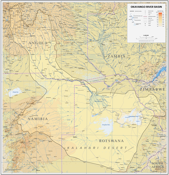
Map of the
Okavango River Basin, with catchment area inside the dotted line (Angola, Namibia, Botswana)
288:
Unless stated otherwise, UN maps are to be considered in the public domain. This applies worldwide.
150:
122:
357:
352:
73:
42:
852:
807:
757:
507:
727:
8:
652:
109:
201:
487:
281:
300:
434:
424:
308:
567:
777:
153:, because the source is a pdf file with a pixel image, not a vector image.
862:
472:
236:
291:
Some UN maps have special copyrights, as indicated on the map itself.
587:
368:
325:
Click on a date/time to view the file as it appeared at that time.
812:
672:
517:
697:
597:
632:
687:
642:
482:
797:
542:
682:
607:
537:
452:
562:
557:
191:
97:
737:
617:
87:(3,052 × 3,160 pixels, file size: 8.63 MB, MIME type:
842:
832:
822:
787:
747:
662:
627:
592:
552:
527:
413:
443:
323:
121:
Commons is a freely licensed media file repository.
240:Expanded part of the map, showing the delta only.
202:https://digitallibrary.un.org/record/423191?ln=en
102:
215:
187:
161:
301:Geospatial, location data for a better world
231:
207:
197:
14:
445:The following other wikis use this file:
235:
415:The following 4 pages use this file:
273:
133:
488:Teza:Xadola/Nelkaf betakseem/08/2021
268:
279:This image is a map derived from a
13:
910:
307:
176:
168:
134:
80:
968:
917:
808:Relações entre Botsuana e Namíbia
169:
272:
142:
101:
31:
21:
177:
778:Lijst van rivieren in Botswana
463:العلاقات البوتسوانية الناميبية
440:
320:
297:Geospatial Information Section
26:
1:
36:
568:Liste der Flüsse in Botswana
410:
164:Okavango River Basin map.png
7:
952:Adobe Photoshop CS2 Windows
907:
614:Usage on frr.wikipedia.org
494:Usage on azb.wikipedia.org
479:Usage on avk.wikipedia.org
469:Usage on ast.wikipedia.org
10:
973:
889:Usage on uk.wikipedia.org
879:Usage on th.wikipedia.org
869:Usage on ta.wikipedia.org
863:Orodha ya mito ya Botswana
859:Usage on sw.wikipedia.org
849:Usage on sr.wikipedia.org
839:Usage on sk.wikipedia.org
829:Usage on sh.wikipedia.org
819:Usage on ro.wikipedia.org
804:Usage on pt.wikipedia.org
794:Usage on pl.wikipedia.org
784:Usage on oc.wikipedia.org
774:Usage on nl.wikipedia.org
764:Usage on ml.wikipedia.org
754:Usage on mk.wikipedia.org
744:Usage on lv.wikipedia.org
734:Usage on lt.wikipedia.org
724:Usage on ko.wikipedia.org
714:Usage on ka.wikipedia.org
704:Usage on ja.wikipedia.org
694:Usage on it.wikipedia.org
679:Usage on id.wikipedia.org
669:Usage on hu.wikipedia.org
659:Usage on hr.wikipedia.org
649:Usage on he.wikipedia.org
639:Usage on gl.wikipedia.org
624:Usage on fr.wikipedia.org
604:Usage on fi.wikipedia.org
584:Usage on es.wikipedia.org
574:Usage on el.wikipedia.org
549:Usage on de.wikipedia.org
534:Usage on da.wikipedia.org
524:Usage on cs.wikipedia.org
514:Usage on ca.wikipedia.org
504:Usage on bg.wikipedia.org
459:Usage on ar.wikipedia.org
449:Usage on af.wikipedia.org
430:List of rivers of Botswana
420:Botswana–Namibia relations
158:
136:
937:File change date and time
16:
518:Conca de l'Okavango
108:This is a file from the
41:
473:Xeografía d'Angola
404:
374:
190:
151:Template:Convert to SVG
112:. Information from its
312:
241:
115:description page there
46:Size of this preview:
921:Horizontal resolution
353:14:22, 6 January 2019
311:
239:
940:12:59, 16 April 2008
400:Foundert~commonswiki
383:17:09, 16 April 2008
74:3,052 × 3,160 pixels
70:1,978 × 2,048 pixels
929:Vertical resolution
698:Bacino del Kalahari
598:Cuenca del Okavango
588:Geografía de Angola
578:Οκαβάνγκο (ποταμός)
52:Other resolutions:
633:Bassin du Kalahari
313:
242:
66:989 × 1,024 pixels
960:
959:
902:more global usage
893:Географія Намібії
688:Cekungan Kalahari
441:Global file usage
408:
317:
316:
267:
266:
246:
245:
224:
221:Reusing this file
130:
129:
110:Wikimedia Commons
32:Global file usage
964:
954:
918:
813:Bacia do Calaári
798:Okawango (rzeka)
673:Kalahári-medence
543:Okavangobassinet
483:Okavango (kuksa)
395:
365:
327:
276:
275:
269:
263:
260:
257:
254:
249:
248:
218:
193:
181:
173:
165:
159:
146:
145:
126:
105:
104:
98:
92:
90:
77:
62:742 × 768 pixels
58:464 × 480 pixels
54:232 × 240 pixels
48:579 × 599 pixels
972:
971:
967:
966:
965:
963:
962:
961:
950:
906:
883:แม่น้ำโอกาวางโก
683:Sungai Okavango
608:Okavango (joki)
538:Okavango (flod)
439:
409:
401:
393:
375:adjust midtones
371:
363:
319:
318:
261:
258:
255:
252:
247:
183:
175:
163:
155:
143:
139:
132:
131:
120:
119:
118:is shown below.
94:
88:
86:
79:
78:
51:
12:
11:
5:
970:
958:
957:
956:
955:
946:
942:
941:
938:
934:
933:
930:
926:
925:
922:
909:
904:of this file.
898:
897:
896:
895:
887:
886:
885:
877:
876:
875:
873:ஒக்கவாங்கோ ஆறு
867:
866:
865:
857:
856:
855:
847:
846:
845:
837:
836:
835:
827:
826:
825:
817:
816:
815:
810:
802:
801:
800:
792:
791:
790:
782:
781:
780:
772:
771:
770:
768:ഒക്കവാങ്കോ നദി
762:
761:
760:
752:
751:
750:
742:
741:
740:
732:
731:
730:
722:
721:
720:
712:
711:
710:
702:
701:
700:
692:
691:
690:
685:
677:
676:
675:
667:
666:
665:
657:
656:
655:
647:
646:
645:
637:
636:
635:
630:
622:
621:
620:
612:
611:
610:
602:
601:
600:
595:
590:
582:
581:
580:
572:
571:
570:
565:
560:
555:
547:
546:
545:
540:
532:
531:
530:
522:
521:
520:
512:
511:
510:
502:
501:
500:
498:اوکاوانقو چایی
492:
491:
490:
485:
477:
476:
475:
467:
466:
465:
457:
456:
455:
453:Okavangorivier
442:
438:
437:
435:Okavango River
432:
427:
425:Kalahari Basin
422:
412:
407:
406:
403:
399:
396:
392:3,052 × 3,160
390:
385:
380:
377:
376:
373:
369:
366:
362:3,052 × 3,160
360:
355:
350:
346:
345:
342:
339:
336:
333:
330:
322:
315:
314:
305:
282:United Nations
277:
265:
264:
244:
243:
233:
232:Other versions
229:
228:
225:
213:
212:
211:United Nations
209:
205:
204:
199:
195:
194:
189:
185:
184:
166:
157:
141:
138:
135:
128:
127:
106:
96:
95:
45:
40:
39:
34:
29:
24:
19:
9:
6:
4:
3:
2:
969:
953:
949:
948:
947:
945:Software used
944:
943:
939:
936:
935:
931:
928:
927:
923:
920:
919:
916:
913:
905:
903:
894:
891:
890:
888:
884:
881:
880:
878:
874:
871:
870:
868:
864:
861:
860:
858:
854:
851:
850:
848:
844:
841:
840:
838:
834:
831:
830:
828:
824:
821:
820:
818:
814:
811:
809:
806:
805:
803:
799:
796:
795:
793:
789:
786:
785:
783:
779:
776:
775:
773:
769:
766:
765:
763:
759:
756:
755:
753:
749:
746:
745:
743:
739:
736:
735:
733:
729:
726:
725:
723:
719:
716:
715:
713:
709:
706:
705:
703:
699:
696:
695:
693:
689:
686:
684:
681:
680:
678:
674:
671:
670:
668:
664:
661:
660:
658:
654:
651:
650:
648:
644:
641:
640:
638:
634:
631:
629:
626:
625:
623:
619:
616:
615:
613:
609:
606:
605:
603:
599:
596:
594:
591:
589:
586:
585:
583:
579:
576:
575:
573:
569:
566:
564:
563:Cuito (Fluss)
561:
559:
556:
554:
551:
550:
548:
544:
541:
539:
536:
535:
533:
529:
526:
525:
523:
519:
516:
515:
513:
509:
506:
505:
503:
499:
496:
495:
493:
489:
486:
484:
481:
480:
478:
474:
471:
470:
468:
464:
461:
460:
458:
454:
451:
450:
448:
447:
446:
436:
433:
431:
428:
426:
423:
421:
418:
417:
416:
402:
397:
391:
389:
386:
384:
381:
379:
378:
372:
367:
361:
359:
356:
354:
351:
348:
347:
343:
340:
337:
334:
331:
329:
328:
326:
310:
306:
304:
302:
298:
292:
290:
289:
284:
283:
278:
271:
270:
256:Public domain
253:Public domain
251:
250:
238:
234:
230:
226:
222:
217:
214:
210:
206:
203:
200:
196:
192:16 April 2008
186:
180:
172:
167:
160:
156:
154:
152:
124:
117:
116:
111:
107:
100:
99:
93:
84:
83:Original file
75:
71:
67:
63:
59:
55:
49:
44:
38:
35:
33:
30:
28:
25:
23:
20:
18:
15:
914:
911:
899:
643:Río Okavango
558:Nata (Fluss)
444:
414:
324:
321:File history
293:
287:
286:
280:
227:UN map as PD
178:
170:
148:
140:
123:You can help
113:
81:
22:File history
171:Afrikaans:
162:Description
149:Do not add
411:File usage
338:Dimensions
216:Permission
27:File usage
932:37.79 dpc
924:37.79 dpc
738:Okavangas
394:(8.15 MB)
364:(8.63 MB)
335:Thumbnail
332:Date/Time
179:English:
89:image/png
908:Metadata
853:Окаванго
843:Okavango
833:Okavango
823:Okavango
788:Okavango
758:Окаванго
748:Okavango
718:ოკავანგო
663:Okavango
628:Okavango
618:Okavango
593:Okavango
553:Okavango
528:Okavango
508:Окаванго
37:Metadata
708:オカヴァンゴ川
653:אוקבנגו
349:current
344:Comment
299:. And:
137:Summary
85:
208:Author
198:Source
147:
900:View
728:오카방고강
285:map.
262:false
259:false
341:User
188:Date
17:File
370:JMK
303:.
72:|
68:|
64:|
60:|
56:|
50:.
223:)
219:(
125:.
91:)
76:.
Text is available under the Creative Commons Attribution-ShareAlike License. Additional terms may apply.


