158:
142:
22:
227:
165:
377:
in the early 1900s, being a rail-cum-road bridge (first rail-cum-road bridge in India) It facilitates the movement of dozen of trains and hundreds of vehicles every day to and from
Jhanjharpur. Jhanjharpur is also connected to number of other places and destination via NH 57.
385:
which is 48 km away from
Jhanjharpur. People can also take their flights for the different cities of India from the Lok Nayak Jayprakash Narayan International Airport which is 191 km away from Jhanjharpur and present in the capital city of Bihar "Patna".
447:
543:
189:
339:
326:
367:
86:
58:
105:
157:
65:
523:
355:
239:
43:
72:
39:
54:
251:
473:
373:
Jhanjharpur town is connected with, Kamla Balan bridge, a century-old 220 ft bridge built by the
141:
32:
498:
312:
8:
79:
351:
256:
382:
292:
374:
537:
204:
191:
474:"India Nepal Trade Agreement. India-Nepal Foreign Treaty of Trade Agreement"
333:
409:
in Nepal are a part of one of the agreed route for Mutual Trade between
368:
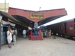
Jhanjharpur is well connected to the other cities of India with railways
429:
has set up a Land
Customs Station with a Superintendent level officer.
425:
has set up a dedicated customs office in the town. and
Government of
320:
308:
303:
21:
402:
394:
426:
422:
418:
414:
410:
406:
398:
363:
359:
296:
244:
232:
397:
is a nearby town close to the border of
Nepalese town of
499:"Department of Customs, Nepal – Custom Contact Offices"
46:. Unsourced material may be challenged and removed.
535:
454:. No. september. live mint. live mint
439:
106:Learn how and when to remove this message
544:Cities and towns in Madhubani district
536:
350:is a town and a sub-division in the
44:adding citations to reliable sources
15:
164:
13:
446:Balan, Kamla (17 September 2008).
14:
555:
445:
225:
163:
156:
140:
20:
31:needs additional citations for
516:
491:
466:
1:
432:
7:
146:Jhanjharpur Railway Station
10:
560:
332:
319:
302:
288:
283:
275:
270:
262:
250:
238:
220:
185:
151:
139:
132:
125:
389:
177:Location in Bihar, India
381:The nearest airport is
266:59 m (194 ft)
289: • Official
120:Town in Bihar, India
40:improve this article
201: /
503:www.customs.gov.np
352:Madhubani district
276: • Total
383:Darbhanga Airport
345:
344:
116:
115:
108:
90:
551:
528:
527:
520:
514:
513:
511:
509:
495:
489:
488:
486:
484:
478:www.eximguru.com
470:
464:
463:
461:
459:
443:
231:
229:
228:
216:
215:
213:
212:
211:
206:
202:
199:
198:
197:
194:
167:
166:
160:
144:
123:
122:
111:
104:
100:
97:
91:
89:
48:
24:
16:
559:
558:
554:
553:
552:
550:
549:
548:
534:
533:
532:
531:
522:
521:
517:
507:
505:
497:
496:
492:
482:
480:
472:
471:
467:
457:
455:
444:
440:
435:
392:
226:
224:
209:
207:
205:26.27°N 86.28°E
203:
200:
195:
192:
190:
188:
187:
181:
180:
179:
178:
175:
174:
173:
172:
168:
147:
135:
128:
121:
112:
101:
95:
92:
49:
47:
37:
25:
12:
11:
5:
557:
547:
546:
530:
529:
515:
490:
465:
437:
436:
434:
431:
421:Government of
391:
388:
343:
342:
337:
330:
329:
324:
317:
316:
306:
300:
299:
290:
286:
285:
281:
280:
277:
273:
272:
268:
267:
264:
260:
259:
254:
248:
247:
242:
236:
235:
222:
218:
217:
183:
182:
176:
170:
169:
162:
161:
155:
154:
153:
152:
149:
148:
145:
137:
136:
133:
130:
129:
126:
119:
114:
113:
28:
26:
19:
9:
6:
4:
3:
2:
556:
545:
542:
541:
539:
525:
519:
504:
500:
494:
479:
475:
469:
453:
449:
448:"Kamla Balan"
442:
438:
430:
428:
424:
420:
416:
412:
408:
405:in India and
404:
400:
396:
387:
384:
379:
376:
371:
369:
365:
361:
357:
353:
349:
341:
338:
335:
331:
328:
325:
322:
318:
314:
310:
307:
305:
301:
298:
294:
291:
287:
282:
278:
274:
269:
265:
261:
258:
255:
253:
249:
246:
243:
241:
237:
234:
223:
219:
214:
186:Coordinates:
184:
159:
150:
143:
138:
131:
124:
118:
110:
107:
99:
88:
85:
81:
78:
74:
71:
67:
64:
60:
57: –
56:
55:"Jhanjharpur"
52:
51:Find sources:
45:
41:
35:
34:
29:This article
27:
23:
18:
17:
518:
508:12 September
506:. Retrieved
502:
493:
483:12 September
481:. Retrieved
477:
468:
456:. Retrieved
451:
441:
393:
380:
372:
347:
346:
336:constituency
334:Vidhan Sabha
323:constituency
210:26.27; 86.28
117:
102:
93:
83:
76:
69:
62:
50:
38:Please help
33:verification
30:
348:Jhanjharpur
340:Jhanjharpur
327:Jhanjharpur
208: /
171:Jhanjharpur
127:Jhanjharpur
433:References
271:Population
96:March 2020
66:newspapers
452:live mint
321:Lok Sabha
304:Time zone
284:Languages
263:Elevation
257:Madhubani
538:Category
309:UTC+5:30
293:Maithili
252:District
524:"No. |"
403:Laukaha
395:Laukaha
375:British
354:of the
221:Country
196:86°17′E
193:26°16′N
80:scholar
458:1 June
279:24,102
230:
82:
75:
68:
61:
53:
427:India
423:Nepal
419:Nepal
415:Nepal
411:India
407:Thadi
399:Thadi
390:Trade
364:India
360:Bihar
356:state
297:Hindi
245:Bihar
240:State
233:India
87:JSTOR
73:books
510:2019
485:2019
460:2019
413:and
134:Town
59:news
358:of
313:IST
42:by
540::
501:.
476:.
450:.
417:.
401:.
370:.
366:.
362:,
295:,
526:.
512:.
487:.
462:.
315:)
311:(
109:)
103:(
98:)
94:(
84:·
77:·
70:·
63:·
36:.
Text is available under the Creative Commons Attribution-ShareAlike License. Additional terms may apply.

