52:
268:
61:
276:
704:
359:. Due to the volume of traffic, and the concentration of heavy-duty transport vehicles, the route is accident-prone, accounting for a large number of injuries and fatalities in the region. In 2013 alone, 3,179 people lost their lives in traffic accidents on the combined Mombasa–Malaba Road.
676:
370:, increasing the number of lanes to twelve, on the island itself. It is expected that solicitation of bids from funders and contractors will be announced before the end of calendar 2016. When completed, the road will become
811:
726:
649:
786:
757:
705:"Distance between DHL House, Nairobi, Nairobi County, Kenya and Digo Road Round About City Clock, Digo Road, Mombasa, Mombasa County, Kenya"
429:
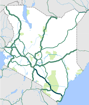
299:. It continues in a general southeasterly direction, through seven Kenya Counties to end in the city of Mombasa at the confluence of
845:
439:
419:
566:
623:
17:
884:
872:
867:
371:
31:
862:
597:
512:
The following major intersections lie along the
Nairobi–Mombasa Road, listed from the west towards the east:
311:, a total distance of about 482 kilometres (300 mi). The coordinates of this road south of the town of
927:
584:
907:
572:
256:
912:
578:
937:
922:
917:
902:
328:
602:
356:
932:
470:
183:
857:
8:
363:
149:
381:
The following towns, listed from west towards the east, are located along the highway:
206:
312:
252:
727:"Location of Nairobi–Mombasa Road, South of Athi River Town, Machakos County, Kenya"
366:
has plans to expand the road to dual carriageway, with a total of six lanes outside
316:
137:
787:"Highway of death: The Mombasa-Malaba highway taking more lives than Al-Shabaab"
540:
475:
462:
367:
240:
157:
145:
141:
133:
896:
559:
521:
762:
414:
404:
399:
319:
are: 01°30'15.0"S, 37°05'20.0"E (Latitude:-1.504167; Longitude:37.088889).
267:
153:
816:
731:
681:
654:
449:
352:
391:
171:
480:
51:
848:
812:"Map Showing the Nairobi–Mombasa Road With All Towns Along the Road"
490:
434:
340:
251:, the country's largest port city. The road is a component of the
544:
536:
525:
517:
500:
485:
444:
424:
386:
355:. The road moves more than 50 percent of all goods traded in the
336:
248:
244:
187:
175:
167:
104:
93:
275:
548:
529:
348:
344:
335:, that links the Kenyan coast to the land-locked countries of
60:
758:"State invites bids for expansion of Nairobi-Mombasa highway"
495:
409:
283:
The road starts in the city of
Nairobi, at the confluence of
123:
555:
454:
179:
785:
Hudson
Gumbihi, and Solomon Koko (11 December 2015).
624:"Uhuru Commissions Expansion of Part of Mombasa Road"
271:
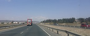
View from the
Standard Gauge Railway to Mombasa city
677:"Location of Southern End of Nairobi–Mombasa Road"
650:"Location of Northern End of Nairobi–Mombasa Road"
894:
885:Mombasa Road: Real Estate, Apartments and Houses
890:((coord|01|30|15|S|37|05|20|E|display=title))
784:
702:
327:This road, together with its sister road,
103:Abdel Nasser Road–Digo Road–Langoni Road,
92:Lang'ata Road–Lusaka Road–Uhuru Highway,
279:The A109 Road near Tsavo junction (2019)
274:
266:
65:The A109 (Nairobi–Mombasa Road) in Kenya
806:
804:
755:
247:, Kenya's capital and largest city and
14:
895:
751:
749:
621:
756:Njoroge, Kiarie (22 September 2016).
801:
746:
703:Globefeed.com (23 September 2016).
24:
622:Kimuyu, Hilary (20 October 2016).
25:
949:
835:
507:
59:
50:
567:Mariakani–Kaloleni–Mavueni Road
778:
719:
696:
669:
642:
615:
524:Road, also referred to as the
79:482 km (300 mi)
13:
1:
608:
598:Trans-African Highway network
7:
873:GPX (secondary coordinates)
591:
322:
262:
10:
954:
573:Dongo Kundu Bypass Highway
372:Nairobi–Mombasa Expressway
32:Nairobi–Mombasa Expressway
29:
868:GPX (primary coordinates)
843:Map all coordinates using
202:
197:
193:
163:
129:
119:
114:
110:
99:
88:
83:
75:
70:
58:
49:
44:
39:
851:Download coordinates as:
585:Malindi–Bagamoyo Highway
376:
30:Not to be confused with
603:List of roads in Kenya
357:East African Community
295:, immediately west of
280:
272:
863:GPX (all coordinates)
471:Samburu, Kwale County
278:
270:
257:Lagos–Mombasa Highway
233:Mombasa–Nairobi Road
579:Mombasa–Garissa Road
255:. It is part of the
229:Nairobi–Mombasa Road
227:, also known as the
45:Nairobi–Mombasa Road
928:Taita-Taveta County
364:government of Kenya
329:Nairobi–Malaba Road
207:Transport in Kenya
908:Streets in Nairobi
543:Road, part of the
281:
273:
100:Southeast end
89:Northwest end
396:Machakos Junction
331:, is part of the
309:Abdel Nasser Road
253:Northern Corridor
237:A109 Road (Kenya)
215:
214:
71:Route information
18:A109 road (Kenya)
16:(Redirected from
945:
829:
828:
826:
824:
808:
799:
798:
796:
794:
782:
776:
775:
773:
771:
753:
744:
743:
741:
739:
723:
717:
716:
714:
712:
700:
694:
693:
691:
689:
673:
667:
666:
664:
662:
646:
640:
639:
637:
635:
619:
341:Eastern DR Congo
333:Great North Road
63:
54:
37:
36:
21:
953:
952:
948:
947:
946:
944:
943:
942:
913:Machakos County
893:
892:
881:
880:
879:
878:
877:
838:
833:
832:
822:
820:
810:
809:
802:
792:
790:
789:. The Nairobian
783:
779:
769:
767:
754:
747:
737:
735:
725:
724:
720:
710:
708:
707:. Globefeed.com
701:
697:
687:
685:
675:
674:
670:
660:
658:
648:
647:
643:
633:
631:
620:
616:
611:
594:
510:
505:
379:
325:
317:Machakos County
265:
222:
221:
220:
84:Major junctions
66:
35:
28:
23:
22:
15:
12:
11:
5:
951:
941:
940:
938:Mombasa County
935:
930:
925:
923:Makueni County
920:
918:Kajiado County
915:
910:
905:
903:Roads in Kenya
888:
887:
876:
875:
870:
865:
860:
854:
841:
840:
839:
837:
836:External links
834:
831:
830:
800:
777:
745:
718:
695:
668:
641:
613:
612:
610:
607:
606:
605:
600:
593:
590:
589:
588:
581:
575:
569:
563:
552:
533:
509:
506:
504:
503:
498:
493:
488:
483:
478:
476:Maji ya Chumvi
473:
468:
465:
463:Mackinnon Road
460:
457:
452:
447:
442:
437:
432:
427:
422:
417:
412:
407:
402:
397:
394:
389:
383:
378:
375:
368:Mombasa Island
324:
321:
264:
261:
218:
217:
216:
213:
212:
211:
210:
200:
199:
198:Highway system
195:
194:
191:
190:
165:
161:
160:
131:
127:
126:
121:
117:
116:
112:
111:
108:
107:
101:
97:
96:
90:
86:
85:
81:
80:
77:
73:
72:
68:
67:
64:
56:
55:
47:
46:
42:
41:
26:
9:
6:
4:
3:
2:
950:
939:
936:
934:
931:
929:
926:
924:
921:
919:
916:
914:
911:
909:
906:
904:
901:
900:
898:
891:
886:
883:
882:
874:
871:
869:
866:
864:
861:
859:
856:
855:
853:
852:
847:
846:OpenStreetMap
844:
819:
818:
813:
807:
805:
788:
781:
765:
764:
759:
752:
750:
734:
733:
728:
722:
706:
699:
684:
683:
678:
672:
657:
656:
651:
645:
629:
625:
618:
614:
604:
601:
599:
596:
595:
586:
582:
580:
576:
574:
570:
568:
564:
561:
557:
553:
550:
546:
542:
538:
534:
531:
527:
523:
519:
515:
514:
513:
508:Intersections
502:
499:
497:
494:
492:
489:
487:
484:
482:
479:
477:
474:
472:
469:
466:
464:
461:
458:
456:
453:
451:
448:
446:
443:
441:
438:
436:
433:
431:
428:
426:
423:
421:
418:
416:
413:
411:
408:
406:
403:
401:
398:
395:
393:
390:
388:
385:
384:
382:
374:
373:
369:
365:
360:
358:
354:
350:
346:
342:
338:
334:
330:
320:
318:
314:
310:
306:
302:
298:
294:
290:
289:Uhuru Highway
286:
277:
269:
260:
258:
254:
250:
246:
242:
238:
234:
230:
226:
209:
208:
204:
203:
201:
196:
192:
189:
185:
181:
177:
173:
169:
166:
162:
159:
155:
151:
147:
143:
139:
135:
132:
128:
125:
122:
118:
113:
109:
106:
102:
98:
95:
91:
87:
82:
78:
74:
69:
62:
57:
53:
48:
43:
38:
33:
27:Road in Kenya
19:
933:Kwale County
889:
850:
849:
842:
823:23 September
821:. Retrieved
815:
793:24 September
791:. Retrieved
780:
770:23 September
768:. Retrieved
763:Daily Nation
761:
738:23 September
736:. Retrieved
730:
721:
711:23 September
709:. Retrieved
698:
688:23 September
686:. Retrieved
680:
671:
661:23 September
659:. Retrieved
653:
644:
632:. Retrieved
628:Nairobi News
627:
617:
511:
405:Sultan Hamud
380:
361:
332:
326:
308:
305:Langoni Road
304:
300:
296:
292:
288:
285:Langata Road
284:
282:
239:is the main
236:
232:
228:
225:Mombasa Road
224:
223:
205:
164:Major cities
150:Taita-Taveta
817:Google Maps
732:Google Maps
682:Google Maps
655:Google Maps
450:Mtito Andei
353:South Sudan
293:Lusaka Road
897:Categories
634:22 October
609:References
392:Athi River
313:Athi River
219:Road route
172:Athi River
766:. Nairobi
630:. Nairobi
481:Mariakani
430:Kiunduani
301:Digo Road
297:DHL House
40:A109 Road
592:See also
491:Miritini
435:Mbuinzau
323:Overview
263:Location
243:between
138:Machakos
130:Counties
115:Location
814:(Map).
729:(Map).
679:(Map).
652:(Map).
545:Nairobi
541:Namanga
537:Nairobi
526:Nairobi
518:Nairobi
501:Mombasa
486:Mazeras
445:Kibwezi
425:Makindu
387:Nairobi
337:Burundi
249:Mombasa
245:Nairobi
188:Mombasa
184:Samburu
176:Kibwezi
168:Nairobi
158:Mombasa
146:Makueni
142:Kajiado
134:Nairobi
120:Country
105:Mombasa
94:Nairobi
560:Taveta
549:Arusha
530:Uganda
522:Malaba
459:Maungu
440:Nguumo
420:Kiboko
349:Uganda
345:Rwanda
76:Length
496:Jomvu
415:Simba
410:Emali
400:Konza
377:Towns
231:, or
154:Kwale
124:Kenya
825:2016
795:2016
772:2016
740:2016
713:2016
690:2016
663:2016
636:2016
583:The
577:The
571:The
565:The
562:Road
554:The
551:Road
535:The
532:Road
516:The
467:Taru
362:The
351:and
307:and
291:and
241:road
858:KML
556:Voi
455:Voi
235:or
180:Voi
899::
803:^
760:.
748:^
626:.
347:,
343:,
339:,
315:,
303:,
287:,
259:.
186:,
182:,
178:,
174:,
170:,
156:,
152:,
148:,
144:,
140:,
136:,
827:.
797:.
774:.
742:.
715:.
692:.
665:.
638:.
587:.
558:–
547:–
539:–
528:–
520:–
34:.
20:)
Text is available under the Creative Commons Attribution-ShareAlike License. Additional terms may apply.


