57:
475:
852:
846:
834:
840:
41:
64:
29:
828:
526:
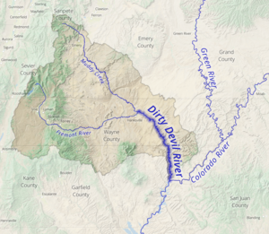
The Dirty Devil River and its tributaries contribute approximately 150,000 tons of salt to the
Colorado River each year, with the Muddy Creek tributary contributing an annual average of 86,000 tons by itself. The Fremont River tributary does not contribute significant amounts of salt. The
531:
drew up a plan to reduce the salinity of the Dirty Devil River by collecting salty spring water and using deep-well injection to dispose of it. The plan, finalized in 1987, has not been implemented due to its
495:, which explored much of the Colorado River and its tributaries. It was named for the extreme salinity and turbidity of the water near its mouth. Powell later contrasted it with a much cleaner stream in the
464:
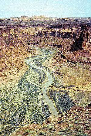
The canyon carved by the river is particularly isolated and seldom visited compared to other natural areas in the region. The average discharge is approximately 446 cubic feet per second.
691:
1259:
672:
1568:
1532:
1234:
1224:
725:
1527:
1537:
1206:
1160:
1087:
577:
255:
1588:
1184:
1165:
1130:
1578:
56:
1469:
1052:
488:
450:
233:
166:
1542:
718:
695:
528:
1507:
1479:
639:
1414:
1072:
953:
1419:
711:
669:
599:
563:
a few miles NE of
Hanksville, UT, just downstream from the confluence of Muddy Creek and the Fremont river.
1484:
982:
958:
1464:
1022:
536:
1474:
1459:
1229:
1583:
1454:
680:
1007:
1573:
1378:
1368:
1340:
1300:
1120:
1512:
1409:
1115:
1501:
1145:
1095:
1002:
556:
552:
446:
237:
112:
1449:
1295:
1274:
1067:
992:
655:
548:
438:
410:
381:
132:
478:
The Dirty Devil River on
February 16, 1954, near crossover by Poison Springs Wash Road in
445:. It flows generally southward through a 2,000-foot-deep (610 m) canyon in Wayne and
8:
1305:
1214:
572:
560:
1547:
1383:
1373:
1335:
1155:
1077:
500:
492:
442:
430:
414:
369:
148:
136:
108:
1037:
1424:
997:
897:
479:
434:
1393:
1345:
1239:
1110:
1062:
1042:
987:
902:
884:
879:
807:
676:
643:
1522:
1264:
1179:
1135:
1012:
963:
734:
454:
398:
217:
1562:
1169:
1105:
1032:
1027:
1017:
921:
600:
U.S. Geological Survey
Geographic Names Information System: Dirty Devil River
533:
511:
507:
270:
257:
181:
168:
88:
636:
1517:
1429:
1269:
1174:
915:
866:
624:
611:
496:
515:
1388:
1363:
1330:
1325:
1315:
1310:
1279:
1189:
1150:
1140:
1047:
910:
892:
871:
458:
418:
229:
212:
703:
1254:
1244:
1219:
1125:
1057:
781:
760:
402:
851:
474:
1320:
1249:
845:
833:
394:
28:
839:
767:
40:
795:
753:
692:
Colorado River Basin
Salinity Control Program, Dirty Devil, Utah
510:
and his gang used tributary canyons of the Dirty Devil, such as
814:
774:
827:
547:
The river is spanned by a bridge a few miles northwest of the
409:. It flows through southern Utah from the confluence of the
788:
406:
241:
152:
98:
449:
counties. Its lower 20 miles (32 km) flows through
656:
http://wdr.water.usgs.gov/wy2013/pdfs/09333500.2013.pdf
71:
Location of the mouth of the Dirty Devil River in Utah
1533:Metropolitan Water District of Southern California
551:, a steel arch bridge over the Colorado River on
33:The Dirty Devil River near Twin Corral Box Canyon
1560:
719:
45:Location of the Dirty Devil River within Utah
487:The Dirty Devil River was named by the 1869
1528:International Boundary and Water Commission
417:before emptying into the Colorado River at
726:
712:
1569:Tributaries of the Colorado River in Utah
733:
646:, The Columbia Gazetteer of North America
578:List of tributaries of the Colorado River
457:at a point that is now submerged beneath
342:35,800 cu ft/s (1,010 m/s)
63:
473:
453:, where it finally disembogues into the
1561:
595:
593:
707:
665:
663:
614:search using GNIS source coordinates.
604:
1470:Glen Canyon National Recreation Area
627:search using GNIS mouth coordinates.
617:
559:. It is also spanned by a bridge on
451:Glen Canyon National Recreation Area
322:101 cu ft/s (2.9 m/s)
234:Glen Canyon National Recreation Area
685:
590:
529:United States Bureau of Reclamation
429:The Dirty Devil River is formed in
13:
1508:Colorado River Board of California
1480:Lake Mead National Recreation Area
660:
630:
14:
1600:
393:is an 80-mile-long (130 km)
1078:Gulf of California/Sea of Cortez
850:
844:
838:
832:
826:
332:0 cu ft/s (0 m/s)
62:
55:
39:
27:
1589:Rivers of Garfield County, Utah
1420:Colorado River Storage Project
649:
610:Source elevation derived from
249: • coordinates
160: • coordinates
1:
1415:Colorado–Big Thompson Project
623:Mouth elevation derived from
583:
119:Physical characteristics
1579:Rivers of Wayne County, Utah
1485:Rocky Mountain National Park
489:Powell Geographic Expedition
292:3,703 ft (1,129 m)
288: • elevation
203:4,266 ft (1,300 m)
199: • elevation
16:River in Utah, United States
7:
1465:Dead Horse Point State Park
1023:Lower Colorado River Valley
566:
225: • location
144: • location
10:
1605:
1543:U.S. Bureau of Reclamation
1475:Grand Canyon National Park
1460:Colorado National Monument
542:
521:
467:
338: • maximum
328: • minimum
318: • average
1493:
1455:Canyonlands National Park
1442:
1402:
1354:
1288:
1205:
1198:
1086:
975:
859:
824:
742:
681:Bureau of Land Management
437:at the confluence of the
424:
375:
363:
355:
350:
346:
336:
326:
316:
308:
304:
296:
286:
247:
223:
211:
207:
197:
158:
142:
127:
123:
118:
104:
94:
84:
79:
50:
38:
26:
21:
377: • right
300:80 mi (130 km)
1379:Central Arizona Project
1369:Colorado River Aqueduct
1341:Theodore Roosevelt Lake
1301:Flaming Gorge Reservoir
642:March 19, 2006, at the
365: • left
1513:Colorado River Compact
1410:Boulder Canyon Project
482:
271:37.89167°N 110.39250°W
182:38.40250°N 110.69306°W
1502:Arizona v. California
1146:Little Colorado River
477:
1450:Arches National Park
1296:Fontenelle Reservoir
993:Colorado River Basin
933:Middle Granite Gorge
555:near milepost 45 in
549:Hite Crossing Bridge
276:37.89167; -110.39250
187:38.40250; -110.69306
1538:Rapids and features
1306:Blue Mesa Reservoir
938:Lower Granite Gorge
573:List of Utah rivers
351:Basin features
267: /
178: /
1548:William Mulholland
1384:All-American Canal
1374:San Diego Aqueduct
1336:Imperial Reservoir
1156:Roaring Fork River
675:2008-11-17 at the
501:Bright Angel Creek
493:John Wesley Powell
483:
1556:
1555:
1438:
1437:
1101:Dirty Devil River
1038:Palo Verde Valley
944:Grand Wash Canyon
889:Horsethief Canyon
670:Dirty Devil River
637:Dirty Devil River
499:, which he named
401:, located in the
391:Dirty Devil River
387:
386:
22:Dirty Devil River
1596:
1584:Colorado Plateau
1443:Designated areas
1425:Grand Valley AVA
1289:Major reservoirs
1203:
1202:
998:Colorado Plateau
976:Natural features
939:
934:
929:
924:
898:Westwater Canyon
854:
848:
842:
836:
830:
817:
810:
798:
791:
784:
777:
770:
763:
756:
728:
721:
714:
705:
704:
698:
689:
683:
667:
658:
653:
647:
634:
628:
621:
615:
608:
602:
597:
378:
366:
339:
329:
319:
282:
281:
279:
278:
277:
272:
268:
265:
264:
263:
260:
200:
193:
192:
190:
189:
188:
183:
179:
176:
175:
174:
171:
161:
145:
66:
65:
59:
43:
31:
19:
18:
1604:
1603:
1599:
1598:
1597:
1595:
1594:
1593:
1559:
1558:
1557:
1552:
1489:
1434:
1398:
1394:Coachella Canal
1356:
1350:
1346:San Carlos Lake
1284:
1215:Shadow Mountain
1194:
1111:Escalante River
1082:
1073:Montague Island
1063:Imperial Valley
1043:Colorado Desert
988:Rocky Mountains
971:
937:
932:
927:
920:
903:Cataract Canyon
885:De Beque Canyon
880:Glenwood Canyon
855:
849:
843:
837:
831:
822:
813:
808:Baja California
806:
794:
787:
780:
773:
766:
759:
752:
738:
732:
702:
701:
690:
686:
677:Wayback Machine
668:
661:
654:
650:
644:Wayback Machine
635:
631:
622:
618:
609:
605:
598:
591:
586:
569:
557:Garfield County
545:
524:
485:
484:
470:
427:
376:
364:
337:
327:
317:
289:
275:
273:
269:
266:
261:
258:
256:
254:
253:
250:
238:Garfield County
226:
198:
186:
184:
180:
177:
172:
169:
167:
165:
164:
159:
143:
113:Garfield County
75:
74:
73:
72:
69:
68:
67:
46:
34:
17:
12:
11:
5:
1602:
1592:
1591:
1586:
1581:
1576:
1574:Rivers of Utah
1571:
1554:
1553:
1551:
1550:
1545:
1540:
1535:
1530:
1525:
1520:
1515:
1510:
1505:
1497:
1495:
1494:Related topics
1491:
1490:
1488:
1487:
1482:
1477:
1472:
1467:
1462:
1457:
1452:
1446:
1444:
1440:
1439:
1436:
1435:
1433:
1432:
1427:
1422:
1417:
1412:
1406:
1404:
1403:Water projects
1400:
1399:
1397:
1396:
1391:
1386:
1381:
1376:
1371:
1366:
1360:
1358:
1352:
1351:
1349:
1348:
1343:
1338:
1333:
1328:
1323:
1318:
1313:
1308:
1303:
1298:
1292:
1290:
1286:
1285:
1283:
1282:
1277:
1272:
1267:
1262:
1257:
1252:
1247:
1242:
1237:
1232:
1227:
1222:
1217:
1211:
1209:
1200:
1196:
1195:
1193:
1192:
1187:
1182:
1180:Las Vegas Wash
1177:
1172:
1163:
1161:San Juan River
1158:
1153:
1148:
1143:
1138:
1136:Gunnison River
1133:
1128:
1123:
1118:
1113:
1108:
1103:
1098:
1092:
1090:
1084:
1083:
1081:
1080:
1075:
1070:
1065:
1060:
1055:
1050:
1045:
1040:
1035:
1030:
1025:
1020:
1015:
1013:Sonoran Desert
1010:
1008:Horseshoe Bend
1005:
1000:
995:
990:
985:
979:
977:
973:
972:
970:
969:
966:
964:Pyramid Canyon
961:
956:
954:Boulder Canyon
951:
948:
947:Iceberg Canyon
945:
942:
941:
940:
935:
930:
925:
913:
908:
905:
900:
895:
890:
887:
882:
877:
874:
869:
863:
861:
857:
856:
825:
823:
821:
820:
819:
818:
811:
801:
800:
799:
792:
785:
778:
771:
764:
757:
749:United States
746:
744:
740:
739:
735:Colorado River
731:
730:
723:
716:
708:
700:
699:
684:
659:
648:
629:
616:
603:
588:
587:
585:
582:
581:
580:
575:
568:
565:
561:State Route 24
553:State Route 95
544:
541:
523:
520:
518:in the 1890s.
472:
471:
469:
466:
455:Colorado River
426:
423:
399:Colorado River
385:
384:
379:
373:
372:
367:
361:
360:
357:
353:
352:
348:
347:
344:
343:
340:
334:
333:
330:
324:
323:
320:
314:
313:
310:
306:
305:
302:
301:
298:
294:
293:
290:
287:
284:
283:
251:
248:
245:
244:
227:
224:
221:
220:
218:Colorado River
215:
209:
208:
205:
204:
201:
195:
194:
162:
156:
155:
146:
140:
139:
131:Confluence of
129:
125:
124:
121:
120:
116:
115:
106:
102:
101:
96:
92:
91:
86:
82:
81:
77:
76:
70:
61:
60:
54:
53:
52:
51:
48:
47:
44:
36:
35:
32:
24:
23:
15:
9:
6:
4:
3:
2:
1601:
1590:
1587:
1585:
1582:
1580:
1577:
1575:
1572:
1570:
1567:
1566:
1564:
1549:
1546:
1544:
1541:
1539:
1536:
1534:
1531:
1529:
1526:
1524:
1521:
1519:
1516:
1514:
1511:
1509:
1506:
1504:
1503:
1499:
1498:
1496:
1492:
1486:
1483:
1481:
1478:
1476:
1473:
1471:
1468:
1466:
1463:
1461:
1458:
1456:
1453:
1451:
1448:
1447:
1445:
1441:
1431:
1428:
1426:
1423:
1421:
1418:
1416:
1413:
1411:
1408:
1407:
1405:
1401:
1395:
1392:
1390:
1387:
1385:
1382:
1380:
1377:
1375:
1372:
1370:
1367:
1365:
1362:
1361:
1359:
1355:Aqueducts and
1353:
1347:
1344:
1342:
1339:
1337:
1334:
1332:
1329:
1327:
1324:
1322:
1319:
1317:
1314:
1312:
1309:
1307:
1304:
1302:
1299:
1297:
1294:
1293:
1291:
1287:
1281:
1278:
1276:
1273:
1271:
1268:
1266:
1263:
1261:
1260:Headgate Rock
1258:
1256:
1253:
1251:
1248:
1246:
1243:
1241:
1238:
1236:
1233:
1231:
1228:
1226:
1223:
1221:
1218:
1216:
1213:
1212:
1210:
1208:
1207:Mainstem dams
1204:
1201:
1197:
1191:
1188:
1186:
1185:Williams Fork
1183:
1181:
1178:
1176:
1173:
1171:
1170:Tapeats Creek
1167:
1166:Thunder River
1164:
1162:
1159:
1157:
1154:
1152:
1149:
1147:
1144:
1142:
1139:
1137:
1134:
1132:
1129:
1127:
1124:
1122:
1119:
1117:
1114:
1112:
1109:
1107:
1106:Dolores River
1104:
1102:
1099:
1097:
1094:
1093:
1091:
1089:
1085:
1079:
1076:
1074:
1071:
1069:
1066:
1064:
1061:
1059:
1056:
1054:
1051:
1049:
1046:
1044:
1041:
1039:
1036:
1034:
1033:Parker Valley
1031:
1029:
1028:Mohave Valley
1026:
1024:
1021:
1019:
1018:Mojave Desert
1016:
1014:
1011:
1009:
1006:
1004:
1001:
999:
996:
994:
991:
989:
986:
984:
981:
980:
978:
974:
968:Mohave Canyon
967:
965:
962:
960:
957:
955:
952:
950:Virgin Canyon
949:
946:
943:
936:
931:
928:Granite Gorge
926:
923:
922:Marble Canyon
919:
918:
917:
914:
912:
909:
907:Narrow Canyon
906:
904:
901:
899:
896:
894:
891:
888:
886:
883:
881:
878:
875:
873:
870:
868:
865:
864:
862:
858:
853:
847:
841:
835:
829:
816:
812:
809:
805:
804:
802:
797:
793:
790:
786:
783:
779:
776:
772:
769:
765:
762:
758:
755:
751:
750:
748:
747:
745:
743:Jurisdictions
741:
736:
729:
724:
722:
717:
715:
710:
709:
706:
697:
693:
688:
682:
678:
674:
671:
666:
664:
657:
652:
645:
641:
638:
633:
626:
620:
613:
607:
601:
596:
594:
589:
579:
576:
574:
571:
570:
564:
562:
558:
554:
550:
540:
538:
537:effectiveness
535:
534:marginal cost
530:
519:
517:
513:
512:Robbers Roost
509:
508:Butch Cassidy
504:
502:
498:
494:
490:
481:
476:
465:
462:
460:
456:
452:
448:
444:
440:
439:Fremont River
436:
432:
422:
420:
416:
412:
411:Fremont River
408:
404:
400:
396:
392:
383:
382:Fremont River
380:
374:
371:
368:
362:
358:
354:
349:
345:
341:
335:
331:
325:
321:
315:
311:
307:
303:
299:
295:
291:
285:
280:
252:
246:
243:
239:
235:
231:
228:
222:
219:
216:
214:
210:
206:
202:
196:
191:
163:
157:
154:
150:
147:
141:
138:
134:
133:Fremont River
130:
126:
122:
117:
114:
110:
107:
103:
100:
97:
93:
90:
89:United States
87:
83:
78:
58:
49:
42:
37:
30:
25:
20:
1518:Floyd Dominy
1500:
1430:Yuma Project
1230:Grand Valley
1175:Virgin River
1121:Fraser River
1100:
983:River course
959:Black Canyon
916:Grand Canyon
867:Byers Canyon
687:
651:
632:
625:Google Earth
619:
612:Google Earth
606:
546:
525:
505:
497:Grand Canyon
486:
463:
431:Wayne County
428:
390:
388:
149:Wayne County
109:Wayne County
1523:Lee's Ferry
1389:Alamo Canal
1364:Grand Ditch
1331:Lake Havasu
1326:Lake Mohave
1316:Lake Powell
1311:Navajo Lake
1240:Glen Canyon
1235:Price-Stubb
1199:Engineering
1151:Paria River
1141:Kanab Creek
1131:Green River
1116:Eagle River
1088:Tributaries
1048:Alamo River
911:Glen Canyon
893:Ruby Canyon
872:Gore Canyon
506:The outlaw
459:Lake Powell
443:Muddy Creek
419:Lake Powell
415:Muddy Creek
370:Muddy Creek
356:Tributaries
274: /
262:110°23′33″W
230:Lake Powell
185: /
173:110°41′35″W
137:Muddy Creek
1563:Categories
1265:Palo Verde
1126:Gila River
1096:Blue River
1058:Salton Sea
1003:Grand Lake
782:New Mexico
761:California
584:References
480:Hanksville
435:Hanksville
403:U.S. state
259:37°53′30″N
1321:Lake Mead
1225:Windy Gap
1190:Río Hardy
1053:New River
876:Red Gorge
395:tributary
309:Discharge
170:38°24′9″N
1270:Imperial
768:Colorado
673:Archived
640:Archived
567:See also
447:Garfield
80:Location
1280:Morelos
860:Canyons
803:Mexico
796:Wyoming
754:Arizona
543:Bridges
522:Geology
516:hideout
514:, as a
491:led by
468:History
397:of the
85:Country
1357:canals
1275:Laguna
1255:Parker
1245:Hoover
1220:Granby
815:Sonora
775:Nevada
737:system
425:Course
359:
312:
297:Length
128:Source
105:County
1250:Davis
1068:Delta
433:near
213:Mouth
95:State
789:Utah
696:USBR
441:and
413:and
407:Utah
389:The
242:Utah
153:Utah
135:and
99:Utah
405:of
1565::
694:,
679:,
662:^
592:^
539:.
503:.
461:.
421:.
240:,
236:,
232:,
151:,
111:,
1168:/
727:e
720:t
713:v
Text is available under the Creative Commons Attribution-ShareAlike License. Additional terms may apply.


