836:"}},"text\/plain":{"en":{"":"coordinates of the point of view"}}},"{\"value\":{\"latitude\":51.78339,\"longitude\":-0.348,\"altitude\":null,\"precision\":1.0e-5,\"globe\":\"http:\\\/\\\/www.wikidata.org\\\/entity\\\/Q2\"},\"type\":\"globecoordinate\"}":{"text\/html":{"en":{"P1259":"51\u00b047'0.20"N, 0\u00b020'52.80"W"}},"text\/plain":{"en":{"P1259":"51\u00b047'0.20\"N, 0\u00b020'52.80\"W"}}},"{\"value\":{\"entity-type\":\"property\",\"numeric-id\":7787,\"id\":\"P7787\"},\"type\":\"wikibase-entityid\"}":{"text\/html":{"en":{"":"
904:"}},"text\/plain":{"en":{"":"coordinates of depicted place"}}},"{\"value\":{\"latitude\":51.78411,\"longitude\":-0.3477,\"altitude\":null,\"precision\":1.0e-5,\"globe\":\"http:\\\/\\\/www.wikidata.org\\\/entity\\\/Q2\"},\"type\":\"globecoordinate\"}":{"text\/html":{"en":{"P9149":"51\u00b047'2.80"N, 0\u00b020'51.72"W"}},"text\/plain":{"en":{"P9149":"51\u00b047'2.80\"N, 0\u00b020'51.72\"W"}}},"{\"value\":{\"entity-type\":\"property\",\"numeric-id\":7787,\"id\":\"P7787\"},\"type\":\"wikibase-entityid\"}":{"text\/html":{"en":{"":"
1010:"}},"text\/plain":{"en":{"":"checksum"}}},"{\"value\":\"0fd70cc1bc357a310d79b0d97af9f2e448f97cea\",\"type\":\"string\"}":{"text\/html":{"en":{"P4092":"0fd70cc1bc357a310d79b0d97af9f2e448f97cea"}},"text\/plain":{"en":{"P4092":"0fd70cc1bc357a310d79b0d97af9f2e448f97cea"}}},"{\"value\":{\"entity-type\":\"property\",\"numeric-id\":459,\"id\":\"P459\"},\"type\":\"wikibase-entityid\"}":{"text\/html":{"en":{"":"
488:"}},"text\/plain":{"en":{"":"author name string"}}},"{\"value\":\"Ian Capper\",\"type\":\"string\"}":{"text\/html":{"en":{"P2093":"Ian Capper"}},"text\/plain":{"en":{"P2093":"Ian Capper"}}},"{\"value\":{\"entity-type\":\"property\",\"numeric-id\":2699,\"id\":\"P2699\"},\"type\":\"wikibase-entityid\"}":{"text\/html":{"en":{"":"
798:"}},"text\/plain":{"en":{"":"inception"}}},"{\"value\":{\"time\":\"+2006-03-25T00:00:00Z\",\"timezone\":0,\"before\":0,\"after\":0,\"precision\":11,\"calendarmodel\":\"http:\\\/\\\/www.wikidata.org\\\/entity\\\/Q1985727\"},\"type\":\"time\"}":{"text\/html":{"en":{"P571":"25 March 2006"}},"text\/plain":{"en":{"P571":"25 March 2006"}}}}": -->
675:
281:
231:
1006:
223:
295:
245:
316:
354:
359:
72:
496:"}},"text\/plain":{"en":{"P2699":"https:\/\/www.geograph.org.uk\/profile\/16999"}}},"{\"value\":{\"entity-type\":\"property\",\"numeric-id\":3831,\"id\":\"P3831\"},\"type\":\"wikibase-entityid\"}":{"text\/html":{"en":{"":"
683:"}},"text\/plain":{"en":{"P7482":"file available on the internet"}}},"{\"value\":{\"entity-type\":\"property\",\"numeric-id\":7384,\"id\":\"P7384\"},\"type\":\"wikibase-entityid\"}":{"text\/html":{"en":{"":"
500:"}},"text\/plain":{"en":{"":"object of statement has role"}}},"{\"value\":{\"entity-type\":\"item\",\"numeric-id\":33231,\"id\":\"Q33231\"},\"type\":\"wikibase-entityid\"}":{"text\/html":{"en":{"P3831":"
699:"}},"text\/plain":{"en":{"P137":"Geograph Britain and Ireland"}}},"{\"value\":{\"entity-type\":\"property\",\"numeric-id\":973,\"id\":\"P973\"},\"type\":\"wikibase-entityid\"}":{"text\/html":{"en":{"":"
1014:"}},"text\/plain":{"en":{"":"determination method"}}},"{\"value\":{\"entity-type\":\"item\",\"numeric-id\":13414952,\"id\":\"Q13414952\"},\"type\":\"wikibase-entityid\"}":{"text\/html":{"en":{"P459":"
972:"}},"text\/plain":{"en":{"":"media type"}}},"{\"value\":\"image\\\/jpeg\",\"type\":\"string\"}":{"text\/html":{"en":{"P1163":"image\/jpeg"}},"text\/plain":{"en":{"P1163":"image\/jpeg"}}}}": -->
635:"}},"text\/plain":{"en":{"":"copyright license"}}},"{\"value\":{\"entity-type\":\"item\",\"numeric-id\":19068220,\"id\":\"Q19068220\"},\"type\":\"wikibase-entityid\"}":{"text\/html":{"en":{"P275":"
591:"}},"text\/plain":{"en":{"":"copyright status"}}},"{\"value\":{\"entity-type\":\"item\",\"numeric-id\":50423863,\"id\":\"Q50423863\"},\"type\":\"wikibase-entityid\"}":{"text\/html":{"en":{"P6216":"
679:"}},"text\/plain":{"en":{"":"source of file"}}},"{\"value\":{\"entity-type\":\"item\",\"numeric-id\":74228490,\"id\":\"Q74228490\"},\"type\":\"wikibase-entityid\"}":{"text\/html":{"en":{"P7482":"
1077:"}},"text\/plain":{"en":{"":"data size"}}},"{\"value\":{\"amount\":\"+87652\",\"unit\":\"http:\\\/\\\/www.wikidata.org\\\/entity\\\/Q8799\"},\"type\":\"quantity\"}":{"text\/html":{"en":{"P3575":"87,652
1122:"}},"text\/plain":{"en":{"":"height"}}},"{\"value\":{\"amount\":\"+426\",\"unit\":\"http:\\\/\\\/www.wikidata.org\\\/entity\\\/Q355198\"},\"type\":\"quantity\"}":{"text\/html":{"en":{"P2048":"426
695:"}},"text\/plain":{"en":{"":"operator"}}},"{\"value\":{\"entity-type\":\"item\",\"numeric-id\":1503119,\"id\":\"Q1503119\"},\"type\":\"wikibase-entityid\"}":{"text\/html":{"en":{"P137":"
1167:"}},"text\/plain":{"en":{"":"width"}}},"{\"value\":{\"amount\":\"+640\",\"unit\":\"http:\\\/\\\/www.wikidata.org\\\/entity\\\/Q355198\"},\"type\":\"quantity\"}":{"text\/html":{"en":{"P2049":"640
908:"}},"text\/plain":{"en":{"":"heading"}}},"{\"value\":{\"amount\":\"+22\",\"unit\":\"http:\\\/\\\/www.wikidata.org\\\/entity\\\/Q28390\"},\"type\":\"quantity\"}":{"text\/html":{"en":{"P7787":"22
840:"}},"text\/plain":{"en":{"":"heading"}}},"{\"value\":{\"amount\":\"+22\",\"unit\":\"http:\\\/\\\/www.wikidata.org\\\/entity\\\/Q28390\"},\"type\":\"quantity\"}":{"text\/html":{"en":{"P7787":"22
691:"}},"text\/plain":{"en":{"P7384":"604851"}}},"{\"value\":{\"entity-type\":\"property\",\"numeric-id\":137,\"id\":\"P137\"},\"type\":\"wikibase-entityid\"}":{"text\/html":{"en":{"":"
484:"}},"text\/plain":{"en":{"":"creator"}}},"{\"value\":{\"entity-type\":\"property\",\"numeric-id\":2093,\"id\":\"P2093\"},\"type\":\"wikibase-entityid\"}":{"text\/html":{"en":{"":"
1163:
703:"}},"text\/plain":{"en":{"":"described at URL"}}},"{\"value\":\"https:\\\/\\\/www.geograph.org.uk\\\/photo\\\/604851\",\"type\":\"string\"}":{"text\/html":{"en":{"P973":"
492:"}},"text\/plain":{"en":{"":"URL"}}},"{\"value\":\"https:\\\/\\\/www.geograph.org.uk\\\/profile\\\/16999\",\"type\":\"string\"}":{"text\/html":{"en":{"P2699":"
43:
687:"}},"text\/plain":{"en":{"":"geograph.org.uk image ID"}}},"{\"value\":\"604851\",\"type\":\"string\"}":{"text\/html":{"en":{"P7384":"
264:
214:
406:– You must give appropriate credit, provide a link to the license, and indicate if changes were made. You may do so in any reasonable manner, but not in any way that suggests the licensor endorses you or your use.
1267:== {{int:filedesc}} == {{Information |description={{en|1=Childwick Green St Mary's Church, on the left, was designed by Sir George Gilbert Scott and built in 1867}} |date=2006-03-25 |source=From |a
278:
228:
1281:
1015:
688:
680:
636:
592:
696:
501:
83:
1164:
1119:
1074:
1007:
969:
905:
901:
837:
833:
684:
676:
588:
497:
489:
485:
51:
493:
1011:
795:
704:
700:
692:
632:
481:
1260:
639:"}},"text\/plain":{"en":{"P275":"Creative Commons Attribution-ShareAlike 2.0 Generic"}}}}": -->
707:"}},"text\/plain":{"en":{"P973":"https:\/\/www.geograph.org.uk\/photo\/604851"}}}}": -->
1059:
730:
662:
618:
288:
238:
765:
323:
1317:
This file contains additional information, probably added from the digital camera or scanner used to create or digitize it.
413:
573:
1178:
1133:
1088:
1025:
979:
946:
919:
878:
851:
743:
714:
602:
566:
551:
538:
1052:
805:
773:
758:
646:
511:
470:
1249:
1244:
42:
369:
1320:
If the file has been modified from its original state, some details may not fully reflect the modified file.
126:
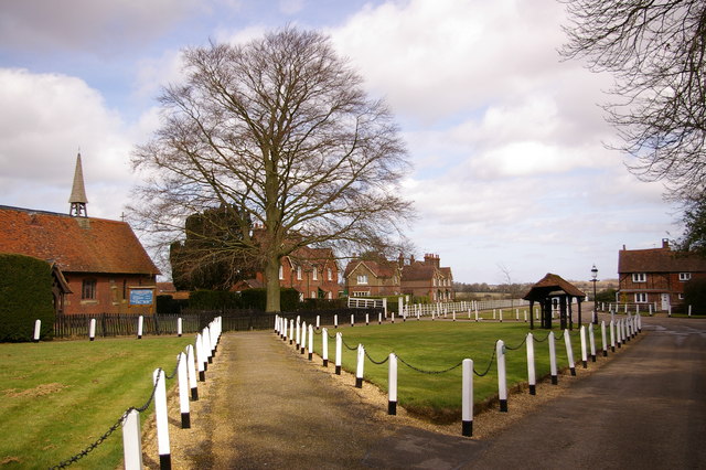
Childwick Green St Mary's Church, on the left, was designed by Sir George
Gilbert Scott and built in 1867
412:– If you remix, transform, or build upon the material, you must distribute your contributions under the
330:
on the
Geograph website for the photographer's contact details. The copyright on this image is owned by
504:"}},"text\/plain":{"en":{"P3831":"photographer"}}}}": -->
1286:
1081:"}},"text\/plain":{"en":{"P3575":"87,652 byte"}}}}": -->
595:"}},"text\/plain":{"en":{"P6216":"copyrighted"}}}}": -->
1171:"}},"text\/plain":{"en":{"P2049":"640 pixel"}}}}": -->
1126:"}},"text\/plain":{"en":{"P2048":"426 pixel"}}}}": -->
912:"}},"text\/plain":{"en":{"P7787":"22 degree"}}}}": -->
844:"}},"text\/plain":{"en":{"P7787":"22 degree"}}}}": -->
91:
183:
1018:"}},"text\/plain":{"en":{"P459":"SHA-1"}}}}": -->
558:
780:
750:
366:
167:
8:
310:
294:
244:
335:
78:
460:
156:
146:
1188:
1143:
1098:
1035:
989:
929:
861:
815:
724:
656:
612:
521:
315:
1304:
327:
1282:
List of new churches by George
Gilbert Scott in the East of England
1217:
Click on a date/time to view the file as it appeared at that time.
280:
230:
265:
51° 47′ 03″ N, 0° 20′ 52″ W
215:
51° 47′ 00″ N, 0° 20′ 53″ W
135:
66:
454:
Add a one-line explanation of what this file represents
1275:
1295:
1215:
90:
Commons is a freely licensed media file repository.
663:
Creative
Commons Attribution-ShareAlike 2.0 Generic
637:
Creative
Commons Attribution-ShareAlike 2.0 Generic
56:(640 × 426 pixels, file size: 86 KB, MIME type:
423:https://creativecommons.org/licenses/by-sa/2.0
116:Childwick Green - geograph.org.uk - 604851.jpg
71:
52:Childwick_Green_-_geograph.org.uk_-_604851.jpg
494:https:\/\/www.geograph.org.uk\/profile\/16999
429:Creative Commons Attribution-Share Alike 2.0
347:
131:
113:
705:https:\/\/www.geograph.org.uk\/photo\/604851
152:
141:
14:
1168:
1123:
1078:
909:
841:
389:– to copy, distribute and transmit the work
1297:The following other wikis use this file:
559:https://www.geograph.org.uk/profile/16999
1041:0fd70cc1bc357a310d79b0d97af9f2e448f97cea
781:https://www.geograph.org.uk/photo/604851
287:View this and other nearby images on:
237:View this and other nearby images on:
1277:The following 2 pages use this file:
190:
102:
334:and is licensed for reuse under the
255:
205:
1208:
370:Attribution-Share Alike 2.0 Generic
358:
353:
338:Attribution-ShareAlike 2.0 license.
13:
1315:
459:
453:
344:
321:
120:
103:
49:
1341:
1322:
458:
852:coordinates of the point of view
834:coordinates of the point of view
444:
400:Under the following conditions:
365:This file is licensed under the
357:
352:
346:
314:
293:
279:
271:
243:
229:
221:
70:
31:
21:
441:
121:
46:No higher resolution available.
1292:
1212:
731:file available on the internet
681:file available on the internet
440:
322:This image was taken from the
26:
1:
920:coordinates of depicted place
902:coordinates of depicted place
36:
1272:
766:Geograph Britain and Ireland
697:Geograph Britain and Ireland
567:object of statement has role
498:object of statement has role
466:Items portrayed in this file
306:
7:
1312:
270:
220:
10:
1346:
1301:Usage on tr.wikipedia.org
935:51°47'2.80"N, 0°20'51.72"W
867:51°47'0.20"N, 0°20'52.80"W
414:same or compatible license
110:
105:
1305:St Michael, Hertfordshire
1287:St Michael, Hertfordshire
1209:
16:
744:geograph.org.uk image ID
685:geograph.org.uk image ID
443:
380:
77:This is a file from the
41:
1266:
196:Ian Capper /
177:Ian Capper /
168:required by the license
134:
81:. Information from its
1245:22:44, 6 February 2011
328:this photograph's page
299:51.784110; -0.347700
249:51.783390; -0.348000
84:description page there
1053:determination method
1012:determination method
395:– to adapt the work
539:author name string
486:author name string
1333:
1332:
1293:Global file usage
1270:
1170:
1125:
1080:
911:
843:
647:copyright license
633:copyright license
452:
343:
342:
326:collection. See
304:
303:
254:
253:
203:
202:
171:
99:
98:
79:Wikimedia Commons
32:Global file usage
1337:
1323:
1257:
1219:
1197:
1152:
1107:
1062:
1057:
957:
956:
951:
889:
888:
883:
783:
778:
774:described at URL
768:
763:
753:
748:
701:described at URL
603:copyright status
589:copyright status
576:
571:
561:
556:
546:
543:
450:
436:
433:
430:
427:
424:
416:as the original.
378:
367:Creative Commons
361:
360:
356:
355:
350:
349:
336:Creative Commons
324:Geograph project
318:
311:
300:
297:
283:
282:
276:
275:
274:
268:
267:
256:
250:
247:
233:
232:
226:
225:
224:
218:
217:
206:
165:
137:
125:
117:
111:
95:
74:
73:
67:
61:
59:
1345:
1344:
1340:
1339:
1338:
1336:
1335:
1334:
1311:
1291:
1271:
1263:
1255:
1211:
1210:
1207:
1206:
1205:
1204:
1203:
1202:
1201:
1200:
1198:
1195:
1185:
1184:
1183:
1181:
1162:
1161:
1160:
1159:
1158:
1157:
1156:
1155:
1153:
1150:
1140:
1139:
1138:
1136:
1117:
1116:
1115:
1114:
1113:
1112:
1111:
1110:
1108:
1105:
1095:
1094:
1093:
1091:
1072:
1071:
1070:
1069:
1068:
1067:
1066:
1065:
1064:
1063:
1058:
1055:
1046:
1045:
1044:
1042:
1032:
1031:
1030:
1028:
1005:
1004:
1003:
1002:
1001:
1000:
999:
998:
996:
986:
985:
984:
982:
967:
966:
965:
964:
963:
962:
961:
960:
959:
958:
954:
952:
949:
940:
939:
938:
936:
926:
925:
924:
922:
899:
898:
897:
896:
895:
894:
893:
892:
891:
890:
886:
884:
881:
872:
871:
870:
868:
858:
857:
856:
854:
831:
830:
829:
828:
827:
826:
825:
824:
822:
812:
811:
810:
808:
793:
792:
791:
790:
789:
788:
787:
786:
785:
784:
779:
776:
770:
769:
764:
761:
755:
754:
749:
746:
737:
736:
735:
733:
721:
720:
719:
717:
674:
673:
672:
671:
670:
669:
668:
667:
665:
653:
652:
651:
649:
630:
629:
628:
627:
626:
625:
624:
623:
621:
609:
608:
607:
605:
586:
585:
584:
583:
582:
581:
580:
579:
578:
577:
572:
569:
563:
562:
557:
554:
548:
547:
544:
541:
532:
531:
530:
528:
518:
517:
516:
514:
479:
478:
477:
476:
475:
473:
457:
456:
455:
438:
437:
434:
431:
428:
425:
422:
421:
379:
376:
373:
362:
339:
309:
298:
272:
263:
262:
259:Object location
248:
222:
213:
212:
209:Camera location
204:
198:Childwick Green
193:
186:
179:Childwick Green
174:
147:geograph.org.uk
127:
115:
108:
101:
100:
89:
88:
87:is shown below.
63:
57:
55:
48:
47:
12:
11:
5:
1343:
1331:
1330:
1327:
1314:
1310:
1309:
1308:
1307:
1294:
1290:
1289:
1284:
1274:
1269:
1268:
1265:
1261:
1258:
1252:
1247:
1242:
1238:
1237:
1234:
1231:
1228:
1225:
1222:
1214:
1199:
1193:
1191:
1190:
1189:
1187:
1186:
1182:
1177:
1175:
1174:
1173:
1172:
1166:
1154:
1148:
1146:
1145:
1144:
1142:
1141:
1137:
1132:
1130:
1129:
1128:
1127:
1121:
1109:
1103:
1101:
1100:
1099:
1097:
1096:
1092:
1087:
1085:
1084:
1083:
1082:
1076:
1051:
1050:
1049:
1048:
1047:
1043:
1040:
1038:
1037:
1036:
1034:
1033:
1029:
1024:
1022:
1021:
1020:
1019:
1017:
1013:
1009:
997:
994:
992:
991:
990:
988:
987:
983:
978:
976:
975:
974:
973:
971:
945:
944:
943:
942:
941:
937:
934:
932:
931:
930:
928:
927:
923:
918:
916:
915:
914:
913:
907:
903:
877:
876:
875:
874:
873:
869:
866:
864:
863:
862:
860:
859:
855:
850:
848:
847:
846:
845:
839:
835:
823:
820:
818:
817:
816:
814:
813:
809:
804:
802:
801:
800:
799:
797:
772:
771:
757:
756:
742:
741:
740:
739:
738:
734:
729:
727:
726:
725:
723:
722:
718:
715:source of file
713:
711:
710:
709:
708:
706:
702:
698:
694:
690:
686:
682:
678:
677:source of file
666:
661:
659:
658:
657:
655:
654:
650:
645:
643:
642:
641:
640:
638:
634:
622:
617:
615:
614:
613:
611:
610:
606:
601:
599:
598:
597:
596:
594:
590:
565:
564:
550:
549:
537:
536:
535:
534:
533:
529:
526:
524:
523:
522:
520:
519:
515:
510:
508:
507:
506:
505:
503:
499:
495:
491:
487:
483:
474:
469:
467:
464:
463:
462:
461:
449:
448:
445:
442:
420:
419:
418:
417:
407:
398:
397:
396:
390:
383:You are free:
374:
364:
363:
345:
341:
340:
319:
308:
305:
302:
301:
291:
285:
260:
252:
251:
241:
235:
210:
201:
200:
194:
191:
188:
187:
182:
175:
172:
160:
159:
154:
150:
149:
143:
139:
138:
133:
129:
128:
118:
109:
107:
104:
97:
96:
75:
65:
64:
45:
40:
39:
34:
29:
24:
19:
9:
6:
4:
3:
2:
1342:
1328:
1325:
1324:
1321:
1318:
1306:
1303:
1302:
1300:
1299:
1298:
1288:
1285:
1283:
1280:
1279:
1278:
1264:
1259:
1253:
1251:
1248:
1246:
1243:
1240:
1239:
1235:
1232:
1229:
1226:
1223:
1221:
1220:
1218:
1192:
1180:
1176:
1147:
1135:
1131:
1102:
1090:
1086:
1061:
1054:
1039:
1027:
1023:
993:
981:
977:
948:
933:
921:
917:
880:
865:
853:
849:
821:25 March 2006
819:
807:
803:
782:
775:
767:
760:
752:
745:
732:
728:
716:
712:
664:
660:
648:
644:
620:
616:
604:
600:
575:
568:
560:
553:
540:
525:
513:
509:
472:
468:
465:
446:
439:
426:CC BY-SA 2.0
415:
411:
408:
405:
402:
401:
399:
394:
391:
388:
385:
384:
382:
381:
375:Attribution:
371:
368:
351:
337:
333:
329:
325:
320:
317:
313:
312:
296:
292:
290:
289:OpenStreetMap
286:
284:
266:
261:
258:
257:
246:
242:
240:
239:OpenStreetMap
236:
234:
216:
211:
208:
207:
199:
195:
189:
185:
181: /
180:
176:
169:
164:
162:
161:
158:
155:
151:
148:
144:
140:
136:25 March 2006
130:
124:
119:
112:
93:
86:
85:
80:
76:
69:
68:
62:
53:
44:
38:
35:
33:
30:
28:
25:
23:
20:
18:
15:
1319:
1316:
1296:
1276:
1216:
1213:File history
574:photographer
502:photographer
409:
403:
392:
386:
331:
269:
219:
197:
184:CC BY-SA 2.0
178:
122:
92:You can help
82:
50:
22:File history
1262:GeographBot
619:copyrighted
593:copyrighted
410:share alike
404:attribution
163:Attribution
114:Description
1326:_error
1273:File usage
1254:640 × 426
1230:Dimensions
995:image/jpeg
980:media type
970:media type
545:Ian Capper
527:some value
377:Ian Capper
332:Ian Capper
157:Ian Capper
58:image/jpeg
27:File usage
1227:Thumbnail
1224:Date/Time
1089:data size
1075:data size
806:inception
796:inception
307:Licensing
192:InfoField
173:InfoField
123:English:
1313:Metadata
1026:checksum
1008:checksum
759:operator
693:operator
447:Captions
393:to remix
387:to share
372:license.
37:Metadata
1256:(86 KB)
1241:current
1236:Comment
1104:87,652
947:heading
906:heading
879:heading
838:heading
512:creator
482:creator
471:depicts
451:English
106:Summary
54:
1134:height
1120:height
955:degree
910:degree
887:degree
842:degree
751:604851
689:604851
277:
227:
153:Author
142:Source
1196:pixel
1179:width
1169:pixel
1165:width
1151:pixel
1124:pixel
1060:SHA-1
1016:SHA-1
145:From
1233:User
1194:640
1149:426
1106:byte
1079:byte
435:true
432:true
132:Date
17:File
953:22
885:22
552:URL
490:URL
1056::
950::
882::
777::
762::
747::
570::
555::
542::
1329:0
170:)
166:(
94:.
60:)
Text is available under the Creative Commons Attribution-ShareAlike License. Additional terms may apply.
_heading:22.00&language=en)
_heading:22.00&language=en)
