903:"}},"text\/plain":{"en":{"":"coordinates of the point of view"}}},"{\"value\":{\"latitude\":51.617727,\"longitude\":-0.01765,\"altitude\":null,\"precision\":1.0e-6,\"globe\":\"http:\\\/\\\/www.wikidata.org\\\/entity\\\/Q2\"},\"type\":\"globecoordinate\"}":{"text\/html":{"en":{"P1259":"51\u00b037'3.817"N, 0\u00b01'3.540"W"}},"text\/plain":{"en":{"P1259":"51\u00b037'3.817\"N, 0\u00b01'3.540\"W"}}},"{\"value\":{\"entity-type\":\"property\",\"numeric-id\":7787,\"id\":\"P7787\"},\"type\":\"wikibase-entityid\"}":{"text\/html":{"en":{"":"
971:"}},"text\/plain":{"en":{"":"coordinates of depicted place"}}},"{\"value\":{\"latitude\":51.61849,\"longitude\":-0.0174,\"altitude\":null,\"precision\":1.0e-5,\"globe\":\"http:\\\/\\\/www.wikidata.org\\\/entity\\\/Q2\"},\"type\":\"globecoordinate\"}":{"text\/html":{"en":{"P9149":"51\u00b037'6.56"N, 0\u00b01'2.64"W"}},"text\/plain":{"en":{"P9149":"51\u00b037'6.56\"N, 0\u00b01'2.64\"W"}}},"{\"value\":{\"entity-type\":\"property\",\"numeric-id\":7787,\"id\":\"P7787\"},\"type\":\"wikibase-entityid\"}":{"text\/html":{"en":{"":"
38:
1077:"}},"text\/plain":{"en":{"":"checksum"}}},"{\"value\":\"381800178e9a1ea5d55d44f9231f6be178dc250e\",\"type\":\"string\"}":{"text\/html":{"en":{"P4092":"381800178e9a1ea5d55d44f9231f6be178dc250e"}},"text\/plain":{"en":{"P4092":"381800178e9a1ea5d55d44f9231f6be178dc250e"}}},"{\"value\":{\"entity-type\":\"property\",\"numeric-id\":459,\"id\":\"P459\"},\"type\":\"wikibase-entityid\"}":{"text\/html":{"en":{"":"
563:"}},"text\/plain":{"en":{"":"author name string"}}},"{\"value\":\"Richard Dunn\",\"type\":\"string\"}":{"text\/html":{"en":{"P2093":"Richard Dunn"}},"text\/plain":{"en":{"P2093":"Richard Dunn"}}},"{\"value\":{\"entity-type\":\"property\",\"numeric-id\":3831,\"id\":\"P3831\"},\"type\":\"wikibase-entityid\"}":{"text\/html":{"en":{"":"
865:"}},"text\/plain":{"en":{"":"inception"}}},"{\"value\":{\"time\":\"+2004-06-01T00:00:00Z\",\"timezone\":0,\"before\":0,\"after\":0,\"precision\":10,\"calendarmodel\":\"http:\\\/\\\/www.wikidata.org\\\/entity\\\/Q1985727\"},\"type\":\"time\"}":{"text\/html":{"en":{"P571":"June 2004"}},"text\/plain":{"en":{"P571":"June 2004"}}}}": -->
742:
348:
298:
1073:
290:
362:
312:
383:
421:
426:
94:
1317:
559:"}},"text\/plain":{"en":{"P2699":"https:\/\/www.geograph.org.uk\/profile\/67727"}}},"{\"value\":{\"entity-type\":\"property\",\"numeric-id\":2093,\"id\":\"P2093\"},\"type\":\"wikibase-entityid\"}":{"text\/html":{"en":{"":"
766:"}},"text\/plain":{"en":{"P973":"https:\/\/www.geograph.org.uk\/photo\/2638823"}}},"{\"value\":{\"entity-type\":\"property\",\"numeric-id\":7384,\"id\":\"P7384\"},\"type\":\"wikibase-entityid\"}":{"text\/html":{"en":{"":"
750:"}},"text\/plain":{"en":{"P7482":"file available on the internet"}}},"{\"value\":{\"entity-type\":\"property\",\"numeric-id\":137,\"id\":\"P137\"},\"type\":\"wikibase-entityid\"}":{"text\/html":{"en":{"":"
567:"}},"text\/plain":{"en":{"":"object of statement has role"}}},"{\"value\":{\"entity-type\":\"item\",\"numeric-id\":33231,\"id\":\"Q33231\"},\"type\":\"wikibase-entityid\"}":{"text\/html":{"en":{"P3831":"
758:"}},"text\/plain":{"en":{"P137":"Geograph Britain and Ireland"}}},"{\"value\":{\"entity-type\":\"property\",\"numeric-id\":973,\"id\":\"P973\"},\"type\":\"wikibase-entityid\"}":{"text\/html":{"en":{"":"
1081:"}},"text\/plain":{"en":{"":"determination method"}}},"{\"value\":{\"entity-type\":\"item\",\"numeric-id\":13414952,\"id\":\"Q13414952\"},\"type\":\"wikibase-entityid\"}":{"text\/html":{"en":{"P459":"
1039:"}},"text\/plain":{"en":{"":"media type"}}},"{\"value\":\"image\\\/jpeg\",\"type\":\"string\"}":{"text\/html":{"en":{"P1163":"image\/jpeg"}},"text\/plain":{"en":{"P1163":"image\/jpeg"}}}}": -->
702:"}},"text\/plain":{"en":{"":"copyright license"}}},"{\"value\":{\"entity-type\":\"item\",\"numeric-id\":19068220,\"id\":\"Q19068220\"},\"type\":\"wikibase-entityid\"}":{"text\/html":{"en":{"P275":"
658:"}},"text\/plain":{"en":{"":"copyright status"}}},"{\"value\":{\"entity-type\":\"item\",\"numeric-id\":50423863,\"id\":\"Q50423863\"},\"type\":\"wikibase-entityid\"}":{"text\/html":{"en":{"P6216":"
746:"}},"text\/plain":{"en":{"":"source of file"}}},"{\"value\":{\"entity-type\":\"item\",\"numeric-id\":74228490,\"id\":\"Q74228490\"},\"type\":\"wikibase-entityid\"}":{"text\/html":{"en":{"P7482":"
1144:"}},"text\/plain":{"en":{"":"data size"}}},"{\"value\":{\"amount\":\"+443854\",\"unit\":\"http:\\\/\\\/www.wikidata.org\\\/entity\\\/Q8799\"},\"type\":\"quantity\"}":{"text\/html":{"en":{"P3575":"443,854
1189:"}},"text\/plain":{"en":{"":"height"}}},"{\"value\":{\"amount\":\"+1200\",\"unit\":\"http:\\\/\\\/www.wikidata.org\\\/entity\\\/Q355198\"},\"type\":\"quantity\"}":{"text\/html":{"en":{"P2048":"1,200
1234:"}},"text\/plain":{"en":{"":"width"}}},"{\"value\":{\"amount\":\"+1600\",\"unit\":\"http:\\\/\\\/www.wikidata.org\\\/entity\\\/Q355198\"},\"type\":\"quantity\"}":{"text\/html":{"en":{"P2049":"1,600
754:"}},"text\/plain":{"en":{"":"operator"}}},"{\"value\":{\"entity-type\":\"item\",\"numeric-id\":1503119,\"id\":\"Q1503119\"},\"type\":\"wikibase-entityid\"}":{"text\/html":{"en":{"P137":"
975:"}},"text\/plain":{"en":{"":"heading"}}},"{\"value\":{\"amount\":\"+0\",\"unit\":\"http:\\\/\\\/www.wikidata.org\\\/entity\\\/Q28390\"},\"type\":\"quantity\"}":{"text\/html":{"en":{"P7787":"0
907:"}},"text\/plain":{"en":{"":"heading"}}},"{\"value\":{\"amount\":\"+0\",\"unit\":\"http:\\\/\\\/www.wikidata.org\\\/entity\\\/Q28390\"},\"type\":\"quantity\"}":{"text\/html":{"en":{"P7787":"0
551:"}},"text\/plain":{"en":{"":"creator"}}},"{\"value\":{\"entity-type\":\"property\",\"numeric-id\":2699,\"id\":\"P2699\"},\"type\":\"wikibase-entityid\"}":{"text\/html":{"en":{"":"
1230:
762:"}},"text\/plain":{"en":{"":"described at URL"}}},"{\"value\":\"https:\\\/\\\/www.geograph.org.uk\\\/photo\\\/2638823\",\"type\":\"string\"}":{"text\/html":{"en":{"P973":"
555:"}},"text\/plain":{"en":{"":"URL"}}},"{\"value\":\"https:\\\/\\\/www.geograph.org.uk\\\/profile\\\/67727\",\"type\":\"string\"}":{"text\/html":{"en":{"P2699":"
770:"}},"text\/plain":{"en":{"":"geograph.org.uk image ID"}}},"{\"value\":\"2638823\",\"type\":\"string\"}":{"text\/html":{"en":{"P7384":"
281:
60:
56:
52:
48:
42:
154:
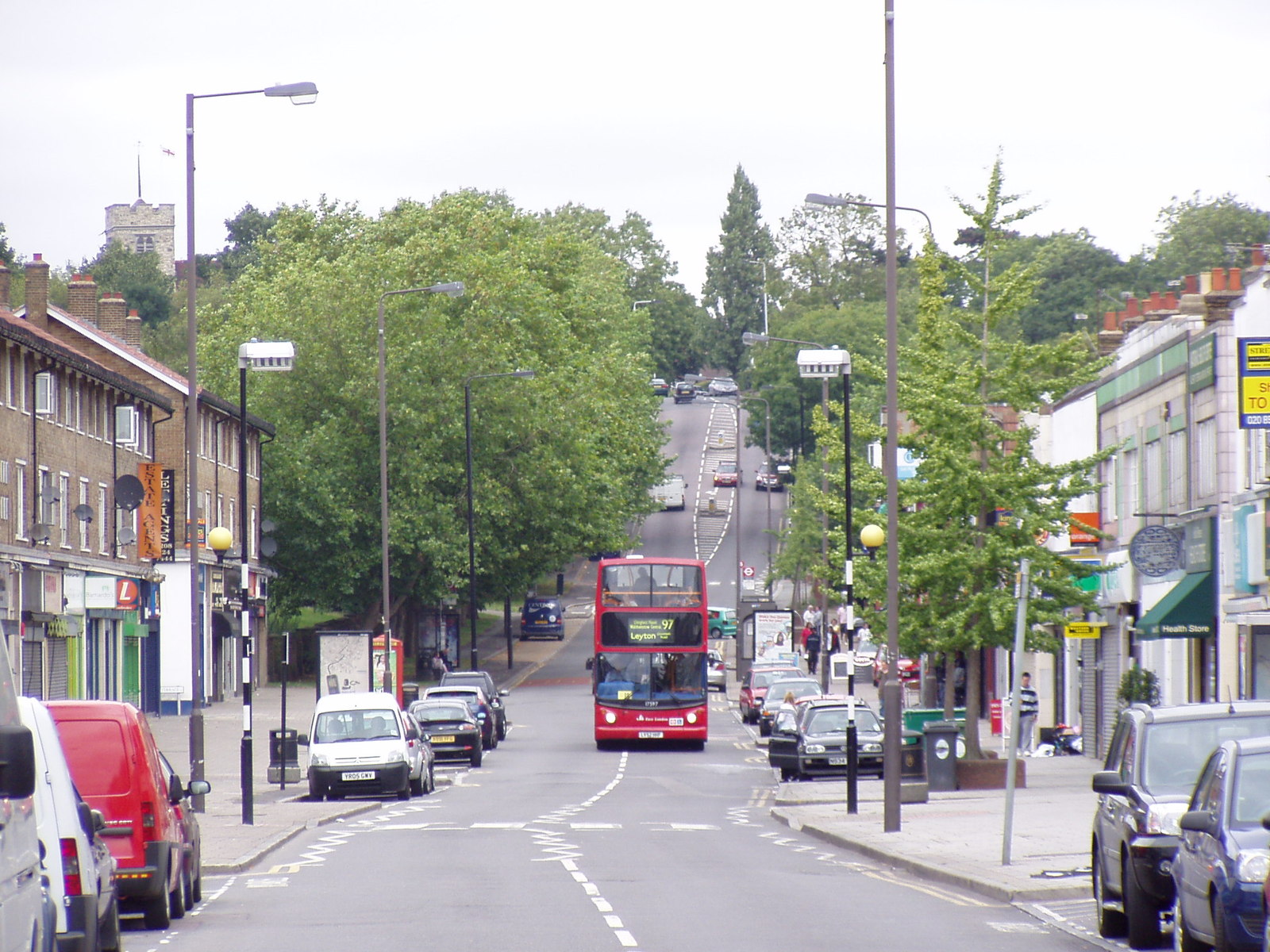
Description: A view looking north up
Chingford Mount (Old Church Road). At the top of the picture on the left can be seen the tower of All Saints Church known locally as the "Old Church" from which the road gets its name. See photo...
73:
105:
473:– You must give appropriate credit, provide a link to the license, and indicate if changes were made. You may do so in any reasonable manner, but not in any way that suggests the licensor endorses you or your use.
295:
345:
1455:
1327:
771:
1082:
747:
703:
659:
755:
568:
1231:
1186:
1141:
1074:
1036:
972:
968:
904:
900:
767:
743:
655:
564:
560:
552:
763:
556:
1078:
862:
759:
751:
699:
548:
1316:
1311:
64:
37:
192:
706:"}},"text\/plain":{"en":{"P275":"Creative Commons Attribution-ShareAlike 2.0 Generic"}}}}": -->
218:
1126:
797:
729:
685:
355:
305:
817:
390:
480:
640:
1245:
1200:
1155:
1092:
1046:
1013:
986:
945:
918:
840:
781:
669:
633:
620:
605:
1119:
872:
825:
810:
713:
578:
537:
1395:
436:
479:– If you remix, transform, or build upon the material, you must distribute your contributions under the
397:
on the
Geograph website for the photographer's contact details. The copyright on this image is owned by
1148:"}},"text\/plain":{"en":{"P3575":"443,854 byte"}}}}": -->
571:"}},"text\/plain":{"en":{"P3831":"photographer"}}}}": -->
1238:"}},"text\/plain":{"en":{"P2049":"1,600 pixel"}}}}": -->
1193:"}},"text\/plain":{"en":{"P2048":"1,200 pixel"}}}}": -->
662:"}},"text\/plain":{"en":{"P6216":"copyrighted"}}}}": -->
979:"}},"text\/plain":{"en":{"P7787":"0 degree"}}}}": -->
911:"}},"text\/plain":{"en":{"P7787":"0 degree"}}}}": -->
774:"}},"text\/plain":{"en":{"P7384":"2638823"}}}}": -->
113:
250:
1365:
1085:"}},"text\/plain":{"en":{"P459":"SHA-1"}}}}": -->
1425:
847:
832:
612:
433:
234:
8:
377:
1475:
361:
311:
402:
100:
527:
158:
164:
Location: (about 2 km from) near to
Chingford, Waltham Forest, Great Britain.
207:
188:
138:
Chingford Mount (Old Church Road) Chingford - geograph.org.uk - 2638823.jpg
1255:
1210:
1165:
1102:
1056:
996:
928:
882:
791:
723:
679:
588:
382:
1500:
394:
1347:
1284:
Click on a date/time to view the file as it appeared at that time.
347:
297:
282:
51° 37′ 03.82″ N, 0° 01′ 03.54″ W
196:
1405:
332:
51° 37′ 06.6″ N, 0° 01′ 03″ W
88:
1465:
521:
Add a one-line explanation of what this file represents
1490:
1445:
1435:
1415:
1385:
1375:
177:
1485:
1341:
78:(1,600 × 1,200 pixels, file size: 433 KB, MIME type:
1356:
1282:
225:
Creative
Commons Attribution Share-alike license 2.0
112:
Commons is a freely licensed media file repository.
730:
Creative
Commons Attribution-ShareAlike 2.0 Generic
704:
Creative
Commons Attribution-ShareAlike 2.0 Generic
490:https://creativecommons.org/licenses/by-sa/2.0
148:Chingford Mount (Old Church Road) Chingford,
93:
764:https:\/\/www.geograph.org.uk\/photo\/2638823
557:https:\/\/www.geograph.org.uk\/profile\/67727
496:Creative Commons Attribution-Share Alike 2.0
414:
213:
173:
135:
203:
183:
14:
1235:
1190:
1145:
976:
908:
456:– to copy, distribute and transmit the work
265:Chingford Mount (Old Church Road) Chingford
246:Chingford Mount (Old Church Road) Chingford
1358:The following other wikis use this file:
833:https://www.geograph.org.uk/photo/2638823
613:https://www.geograph.org.uk/profile/67727
1108:381800178e9a1ea5d55d44f9231f6be178dc250e
354:View this and other nearby images on:
304:View this and other nearby images on:
257:
124:
401:and is licensed for reuse under the
322:
272:
161:: 51.618443013915, -0.01747439224596
1343:The following page uses this file:
1275:
437:Attribution-Share Alike 2.0 Generic
425:
420:
405:Attribution-ShareAlike 2.0 license.
13:
526:
520:
411:
388:
142:
125:
71:
1514:
525:
919:coordinates of the point of view
901:coordinates of the point of view
511:
467:Under the following conditions:
432:This file is licensed under the
424:
419:
413:
381:
360:
346:
338:
310:
296:
288:
92:
31:
21:
1329:File Upload Bot (Magnus Manske)
508:
143:
1353:
1279:
798:file available on the internet
748:file available on the internet
507:
389:This image was taken from the
26:
1:
1456:פורטל:לונדון/כל הערכים החסרים
987:coordinates of depicted place
969:coordinates of depicted place
1338:
818:Geograph Britain and Ireland
756:Geograph Britain and Ireland
634:object of statement has role
565:object of statement has role
533:Items portrayed in this file
373:
7:
1462:Usage on lld.wikipedia.org
1402:Usage on en.wikivoyage.org
1362:Usage on azb.wikipedia.org
10:
1519:
1497:Usage on zh.wikipedia.org
1482:Usage on www.wikidata.org
1472:Usage on ur.wikipedia.org
1452:Usage on he.wikipedia.org
1442:Usage on ga.wikipedia.org
1432:Usage on fr.wikipedia.org
1422:Usage on fa.wikipedia.org
1412:Usage on eu.wikipedia.org
1392:Usage on el.wikipedia.org
1382:Usage on da.wikipedia.org
1372:Usage on cy.wikipedia.org
934:51°37'3.817"N, 0°1'3.540"W
481:same or compatible license
337:
287:
132:
127:
1276:
263:Richard Dunn /
244:Richard Dunn /
16:
1002:51°37'6.56"N, 0°1'2.64"W
841:geograph.org.uk image ID
768:geograph.org.uk image ID
510:
447:
99:This is a file from the
36:
1333:
1312:23:20, 18 February 2012
235:required by the license
176:
103:. Information from its
395:this photograph's page
366:51.618490; -0.017400
316:51.617727; -0.017650
106:description page there
41:Size of this preview:
1120:determination method
1079:determination method
197:geograph_org2commons
151:Data from Geograph:
65:1,600 × 1,200 pixels
462:– to adapt the work
47:Other resolutions:
621:author name string
561:author name string
61:1,280 × 960 pixels
57:1,024 × 768 pixels
1354:Global file usage
1336:
1237:
1192:
1147:
978:
910:
714:copyright license
700:copyright license
519:
410:
409:
393:collection. See
371:
370:
321:
320:
270:
269:
238:
222:
219:Reusing this file
191:; transferred by
121:
120:
101:Wikimedia Commons
32:Global file usage
1510:
1324:
1286:
1264:
1219:
1174:
1129:
1124:
1024:
1023:
1018:
956:
955:
950:
850:
845:
835:
830:
826:described at URL
820:
815:
760:described at URL
670:copyright status
656:copyright status
643:
638:
628:
625:
615:
610:
517:
503:
500:
497:
494:
491:
483:as the original.
445:
434:Creative Commons
428:
427:
423:
422:
417:
416:
403:Creative Commons
391:Geograph project
385:
378:
367:
364:
350:
349:
343:
342:
341:
335:
334:
323:
317:
314:
300:
299:
293:
292:
291:
285:
284:
273:
232:
216:
179:
147:
139:
133:
117:
96:
95:
89:
83:
81:
68:
53:640 × 480 pixels
49:320 × 240 pixels
43:800 × 600 pixels
1518:
1517:
1513:
1512:
1511:
1509:
1508:
1507:
1352:
1337:
1330:
1322:
1278:
1277:
1274:
1273:
1272:
1271:
1270:
1269:
1268:
1267:
1265:
1262:
1252:
1251:
1250:
1248:
1229:
1228:
1227:
1226:
1225:
1224:
1223:
1222:
1220:
1217:
1207:
1206:
1205:
1203:
1184:
1183:
1182:
1181:
1180:
1179:
1178:
1177:
1175:
1172:
1162:
1161:
1160:
1158:
1139:
1138:
1137:
1136:
1135:
1134:
1133:
1132:
1131:
1130:
1125:
1122:
1113:
1112:
1111:
1109:
1099:
1098:
1097:
1095:
1072:
1071:
1070:
1069:
1068:
1067:
1066:
1065:
1063:
1053:
1052:
1051:
1049:
1034:
1033:
1032:
1031:
1030:
1029:
1028:
1027:
1026:
1025:
1021:
1019:
1016:
1007:
1006:
1005:
1003:
993:
992:
991:
989:
966:
965:
964:
963:
962:
961:
960:
959:
958:
957:
953:
951:
948:
939:
938:
937:
935:
925:
924:
923:
921:
898:
897:
896:
895:
894:
893:
892:
891:
889:
879:
878:
877:
875:
860:
859:
858:
857:
856:
855:
854:
853:
852:
851:
846:
843:
837:
836:
831:
828:
822:
821:
816:
813:
804:
803:
802:
800:
788:
787:
786:
784:
741:
740:
739:
738:
737:
736:
735:
734:
732:
720:
719:
718:
716:
697:
696:
695:
694:
693:
692:
691:
690:
688:
676:
675:
674:
672:
653:
652:
651:
650:
649:
648:
647:
646:
645:
644:
639:
636:
630:
629:
626:
623:
617:
616:
611:
608:
599:
598:
597:
595:
585:
584:
583:
581:
546:
545:
544:
543:
542:
540:
524:
523:
522:
505:
504:
501:
498:
495:
492:
489:
488:
446:
443:
440:
429:
406:
376:
365:
339:
330:
329:
326:Object location
315:
289:
280:
279:
276:Camera location
271:
260:
253:
241:
189:geograph.org.uk
169:
137:
130:
123:
122:
111:
110:
109:is shown below.
85:
79:
77:
70:
69:
46:
12:
11:
5:
1516:
1506:
1505:
1504:
1503:
1495:
1494:
1493:
1488:
1480:
1479:
1478:
1470:
1469:
1468:
1460:
1459:
1458:
1450:
1449:
1448:
1440:
1439:
1438:
1430:
1429:
1428:
1420:
1419:
1418:
1410:
1409:
1408:
1400:
1399:
1398:
1390:
1389:
1388:
1380:
1379:
1378:
1370:
1369:
1368:
1355:
1351:
1350:
1340:
1335:
1334:
1332:
1328:
1325:
1321:1,600 × 1,200
1319:
1314:
1309:
1305:
1304:
1301:
1298:
1295:
1292:
1289:
1281:
1266:
1260:
1258:
1257:
1256:
1254:
1253:
1249:
1244:
1242:
1241:
1240:
1239:
1233:
1221:
1215:
1213:
1212:
1211:
1209:
1208:
1204:
1199:
1197:
1196:
1195:
1194:
1188:
1176:
1170:
1168:
1167:
1166:
1164:
1163:
1159:
1154:
1152:
1151:
1150:
1149:
1143:
1118:
1117:
1116:
1115:
1114:
1110:
1107:
1105:
1104:
1103:
1101:
1100:
1096:
1091:
1089:
1088:
1087:
1086:
1084:
1080:
1076:
1064:
1061:
1059:
1058:
1057:
1055:
1054:
1050:
1045:
1043:
1042:
1041:
1040:
1038:
1012:
1011:
1010:
1009:
1008:
1004:
1001:
999:
998:
997:
995:
994:
990:
985:
983:
982:
981:
980:
974:
970:
944:
943:
942:
941:
940:
936:
933:
931:
930:
929:
927:
926:
922:
917:
915:
914:
913:
912:
906:
902:
890:
887:
885:
884:
883:
881:
880:
876:
871:
869:
868:
867:
866:
864:
839:
838:
824:
823:
809:
808:
807:
806:
805:
801:
796:
794:
793:
792:
790:
789:
785:
782:source of file
780:
778:
777:
776:
775:
773:
769:
765:
761:
757:
753:
749:
745:
744:source of file
733:
728:
726:
725:
724:
722:
721:
717:
712:
710:
709:
708:
707:
705:
701:
689:
684:
682:
681:
680:
678:
677:
673:
668:
666:
665:
664:
663:
661:
657:
632:
631:
619:
618:
604:
603:
602:
601:
600:
596:
593:
591:
590:
589:
587:
586:
582:
577:
575:
574:
573:
572:
570:
566:
562:
558:
554:
550:
541:
536:
534:
531:
530:
529:
528:
516:
515:
512:
509:
487:
486:
485:
484:
474:
465:
464:
463:
457:
450:You are free:
441:
431:
430:
412:
408:
407:
386:
375:
372:
369:
368:
358:
352:
327:
319:
318:
308:
302:
277:
268:
267:
261:
258:
255:
254:
249:
242:
239:
227:
226:
223:
211:
210:
205:
201:
200:
185:
181:
180:
175:
171:
170:
168:
167:
166:
165:
162:
156:
140:
131:
129:
126:
119:
118:
97:
87:
86:
40:
35:
34:
29:
24:
19:
9:
6:
4:
3:
2:
1515:
1502:
1499:
1498:
1496:
1492:
1489:
1487:
1484:
1483:
1481:
1477:
1474:
1473:
1471:
1467:
1464:
1463:
1461:
1457:
1454:
1453:
1451:
1447:
1444:
1443:
1441:
1437:
1434:
1433:
1431:
1427:
1424:
1423:
1421:
1417:
1414:
1413:
1411:
1407:
1406:Epping Forest
1404:
1403:
1401:
1397:
1394:
1393:
1391:
1387:
1384:
1383:
1381:
1377:
1374:
1373:
1371:
1367:
1364:
1363:
1361:
1360:
1359:
1349:
1346:
1345:
1344:
1331:
1326:
1320:
1318:
1315:
1313:
1310:
1307:
1306:
1302:
1299:
1296:
1293:
1290:
1288:
1287:
1285:
1259:
1247:
1243:
1214:
1202:
1198:
1169:
1157:
1153:
1128:
1121:
1106:
1094:
1090:
1060:
1048:
1044:
1015:
1000:
988:
984:
947:
932:
920:
916:
886:
874:
870:
849:
842:
834:
827:
819:
812:
799:
795:
783:
779:
731:
727:
715:
711:
687:
683:
671:
667:
642:
635:
622:
614:
607:
592:
580:
576:
539:
535:
532:
513:
506:
493:CC BY-SA 2.0
482:
478:
475:
472:
469:
468:
466:
461:
458:
455:
452:
451:
449:
448:
442:Attribution:
438:
435:
418:
404:
400:
396:
392:
387:
384:
380:
379:
363:
359:
357:
356:OpenStreetMap
353:
351:
333:
328:
325:
324:
313:
309:
307:
306:OpenStreetMap
303:
301:
283:
278:
275:
274:
266:
262:
256:
252:
248: /
247:
243:
236:
231:
229:
228:
224:
220:
215:
212:
209:
206:
202:
198:
194:
190:
186:
182:
172:
163:
160:
157:
153:
152:
150:
149:
146:
141:
134:
115:
108:
107:
102:
98:
91:
90:
84:
75:
74:Original file
66:
62:
58:
54:
50:
44:
39:
33:
30:
28:
25:
23:
20:
18:
15:
1357:
1342:
1283:
1280:File history
641:photographer
627:Richard Dunn
569:photographer
476:
470:
459:
453:
444:Richard Dunn
399:Richard Dunn
398:
336:
286:
264:
251:CC BY-SA 2.0
245:
208:Richard Dunn
144:
114:You can help
104:
72:
22:File history
1396:Τσίνγκφορντ
686:copyrighted
660:copyrighted
477:share alike
471:attribution
230:Attribution
193:User:Ultra7
136:Description
1339:File usage
1297:Dimensions
1062:image/jpeg
1047:media type
1037:media type
594:some value
214:Permission
80:image/jpeg
27:File usage
1491:Q15932817
1466:Chingford
1446:Chingford
1436:Chingford
1416:Chingford
1386:Chingford
1376:Chingford
1348:Chingford
1294:Thumbnail
1291:Date/Time
1156:data size
1142:data size
888:June 2004
873:inception
863:inception
374:Licensing
259:InfoField
240:InfoField
178:June 2004
145:English:
1486:Q3778007
1426:چینگفورد
1366:چینقفورد
1323:(433 KB)
1171:443,854
1093:checksum
1075:checksum
811:operator
752:operator
514:Captions
460:to remix
454:to share
439:license.
1476:چنگفورڈ
1308:current
1303:Comment
1014:heading
973:heading
946:heading
905:heading
848:2638823
772:2638823
579:creator
549:creator
538:depicts
518:English
128:Summary
76:
1261:1,600
1216:1,200
1201:height
1187:height
1022:degree
977:degree
954:degree
909:degree
344:
294:
204:Author
195:using
184:Source
1263:pixel
1246:width
1236:pixel
1232:width
1218:pixel
1191:pixel
1127:SHA-1
1083:SHA-1
187:From
1300:User
1173:byte
1146:byte
502:true
499:true
174:Date
159:ICBM
155:more
17:File
1501:清福德
606:URL
553:URL
1123::
1020:0
1017::
952:0
949::
844::
829::
814::
637::
624::
609::
63:|
59:|
55:|
51:|
45:.
237:)
233:(
221:)
217:(
199:.
116:.
82:)
67:.
Text is available under the Creative Commons Attribution-ShareAlike License. Additional terms may apply.
_Chingford_-_geograph.org.uk_-_2638823.jpg)
_Chingford_-_geograph.org.uk_-_2638823.jpg¶ms=051.617727_N_-000.017650_E_globe:Earth_type:camera_heading:0.00_source:geograph&language=en)
_Chingford_-_geograph.org.uk_-_2638823.jpg¶ms=051.618490_N_-000.017400_E_globe:Earth_class:object_type:object_source:geograph-osgb36(TQ37359293)_region:GB-GBN_heading:0.00&language=en)