820:"}},"text\/plain":{"en":{"":"coordinates of the point of view"}}},"{\"value\":{\"latitude\":50.8833,\"longitude\":-0.2114,\"altitude\":null,\"precision\":0.0001,\"globe\":\"http:\\\/\\\/www.wikidata.org\\\/entity\\\/Q2\"},\"type\":\"globecoordinate\"}":{"text\/html":{"en":{"P1259":"50\u00b052'59.9"N, 0\u00b012'41.0"W"}},"text\/plain":{"en":{"P1259":"50\u00b052'59.9\"N, 0\u00b012'41.0\"W"}}}}": -->
858:"}},"text\/plain":{"en":{"":"coordinates of depicted place"}}},"{\"value\":{\"latitude\":50.88,\"longitude\":-0.2,\"altitude\":null,\"precision\":0.001,\"globe\":\"http:\\\/\\\/www.wikidata.org\\\/entity\\\/Q2\"},\"type\":\"globecoordinate\"}":{"text\/html":{"en":{"P9149":"50\u00b052'48"N, 0\u00b012'0"W"}},"text\/plain":{"en":{"P9149":"50\u00b052'48\"N, 0\u00b012'0\"W"}}}}": -->
480:"}},"text\/plain":{"en":{"":"author name string"}}},"{\"value\":\"Val Vannet\",\"type\":\"string\"}":{"text\/html":{"en":{"P2093":"Val Vannet"}},"text\/plain":{"en":{"P2093":"Val Vannet"}}},"{\"value\":{\"entity-type\":\"property\",\"numeric-id\":2699,\"id\":\"P2699\"},\"type\":\"wikibase-entityid\"}":{"text\/html":{"en":{"":"
782:"}},"text\/plain":{"en":{"":"inception"}}},"{\"value\":{\"time\":\"+2005-07-18T00:00:00Z\",\"timezone\":0,\"before\":0,\"after\":0,\"precision\":11,\"calendarmodel\":\"http:\\\/\\\/www.wikidata.org\\\/entity\\\/Q1985727\"},\"type\":\"time\"}":{"text\/html":{"en":{"P571":"18 July 2005"}},"text\/plain":{"en":{"P571":"18 July 2005"}}}}": -->
659:
464:
223:
279:
237:
300:
338:
343:
72:
667:"}},"text\/plain":{"en":{"P7482":"file available on the internet"}}},"{\"value\":{\"entity-type\":\"property\",\"numeric-id\":7384,\"id\":\"P7384\"},\"type\":\"wikibase-entityid\"}":{"text\/html":{"en":{"":"
472:"}},"text\/plain":{"en":{"":"object of statement has role"}}},"{\"value\":{\"entity-type\":\"item\",\"numeric-id\":33231,\"id\":\"Q33231\"},\"type\":\"wikibase-entityid\"}":{"text\/html":{"en":{"P3831":"
683:"}},"text\/plain":{"en":{"P137":"Geograph Britain and Ireland"}}},"{\"value\":{\"entity-type\":\"property\",\"numeric-id\":973,\"id\":\"P973\"},\"type\":\"wikibase-entityid\"}":{"text\/html":{"en":{"":"
619:"}},"text\/plain":{"en":{"":"copyright license"}}},"{\"value\":{\"entity-type\":\"item\",\"numeric-id\":19068220,\"id\":\"Q19068220\"},\"type\":\"wikibase-entityid\"}":{"text\/html":{"en":{"P275":"
575:"}},"text\/plain":{"en":{"":"copyright status"}}},"{\"value\":{\"entity-type\":\"item\",\"numeric-id\":50423863,\"id\":\"Q50423863\"},\"type\":\"wikibase-entityid\"}":{"text\/html":{"en":{"P6216":"
663:"}},"text\/plain":{"en":{"":"source of file"}}},"{\"value\":{\"entity-type\":\"item\",\"numeric-id\":74228490,\"id\":\"Q74228490\"},\"type\":\"wikibase-entityid\"}":{"text\/html":{"en":{"P7482":"
476:"}},"text\/plain":{"en":{"P3831":"photographer"}}},"{\"value\":{\"entity-type\":\"property\",\"numeric-id\":2093,\"id\":\"P2093\"},\"type\":\"wikibase-entityid\"}":{"text\/html":{"en":{"":"
679:"}},"text\/plain":{"en":{"":"operator"}}},"{\"value\":{\"entity-type\":\"item\",\"numeric-id\":1503119,\"id\":\"Q1503119\"},\"type\":\"wikibase-entityid\"}":{"text\/html":{"en":{"P137":"
675:"}},"text\/plain":{"en":{"P7384":"30789"}}},"{\"value\":{\"entity-type\":\"property\",\"numeric-id\":137,\"id\":\"P137\"},\"type\":\"wikibase-entityid\"}":{"text\/html":{"en":{"":"
468:"}},"text\/plain":{"en":{"":"creator"}}},"{\"value\":{\"entity-type\":\"property\",\"numeric-id\":3831,\"id\":\"P3831\"},\"type\":\"wikibase-entityid\"}":{"text\/html":{"en":{"":"
854:
687:"}},"text\/plain":{"en":{"":"described at URL"}}},"{\"value\":\"https:\\\/\\\/www.geograph.org.uk\\\/photo\\\/30789\",\"type\":\"string\"}":{"text\/html":{"en":{"P973":"
484:"}},"text\/plain":{"en":{"":"URL"}}},"{\"value\":\"https:\\\/\\\/www.geograph.org.uk\\\/profile\\\/246\",\"type\":\"string\"}":{"text\/html":{"en":{"P2699":"
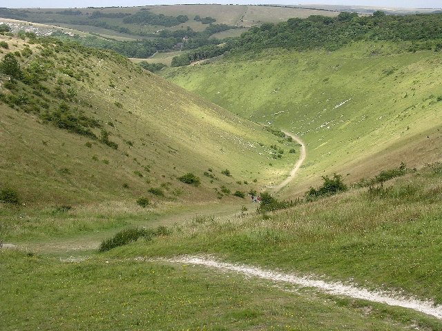
951:== {{int:filedesc}} == {{Information |description={{en|1=Devil's Dyke. This view which is taken from the north west corner of the grid box looks down the dry valley known as Devil's Dyke on the north edge of the South Downs escarpment.}} |date=2005-07-18
43:
671:"}},"text\/plain":{"en":{"":"geograph.org.uk image ID"}}},"{\"value\":\"30789\",\"type\":\"string\"}":{"text\/html":{"en":{"P7384":"
256:
390:– You must give appropriate credit, provide a link to the license, and indicate if changes were made. You may do so in any reasonable manner, but not in any way that suggests the licensor endorses you or your use.
220:
214:
262:
126:
Devil's Dyke. This view which is taken from the north west corner of the grid box looks down the dry valley known as Devil's Dyke on the north edge of the South Downs escarpment.
664:
620:
576:
672:
680:
473:
855:
817:
668:
660:
572:
481:
477:
469:
83:
779:
684:
676:
616:
465:
51:
688:
485:
1102:
944:
623:"}},"text\/plain":{"en":{"P275":"Creative Commons Attribution-ShareAlike 2.0 Generic"}}}}": -->
488:"}},"text\/plain":{"en":{"P2699":"https:\/\/www.geograph.org.uk\/profile\/246"}}}}": -->
691:"}},"text\/plain":{"en":{"P973":"https:\/\/www.geograph.org.uk\/photo\/30789"}}}}": -->
714:
646:
602:
272:
230:
749:
307:
996:
This file contains additional information, probably added from the digital camera or scanner used to create or digitize it.
397:
529:
865:
827:
727:
698:
586:
550:
537:
522:
789:
757:
742:
630:
495:
454:
1133:
933:
928:
353:
42:
999:
If the file has been modified from its original state, some details may not fully reflect the modified file.
396:– If you remix, transform, or build upon the material, you must distribute your contributions under the
314:
on the
Geograph website for the photographer's contact details. The copyright on this image is owned by
579:"}},"text\/plain":{"en":{"P6216":"copyrighted"}}}}": -->
965:
91:
183:
1152:
350:
167:
764:
734:
557:
8:
1188:
294:
278:
236:
319:
78:
444:
1170:
1025:
1065:
156:
146:
1198:
875:
837:
799:
708:
640:
596:
505:
299:
1045:
311:
1035:
901:
Click on a date/time to view the file as it appeared at that time.
264:
222:
215:
50° 52′ 59.88″ N, 0° 12′ 41.04″ W
1018:
1008:
135:
66:
438:
Add a one-line explanation of what this file represents
983:
959:
974:
899:
90:
Commons is a freely licensed media file repository.
647:
Creative
Commons Attribution-ShareAlike 2.0 Generic
621:
Creative
Commons Attribution-ShareAlike 2.0 Generic
56:(640 × 480 pixels, file size: 173 KB, MIME type:
407:https://creativecommons.org/licenses/by-sa/2.0
71:
52:Devil's_Dyke_-_geograph.org.uk_-_30789.jpg
413:Creative Commons Attribution-Share Alike 2.0
331:
131:
113:
152:
141:
14:
689:https:\/\/www.geograph.org.uk\/photo\/30789
486:https:\/\/www.geograph.org.uk\/profile\/246
373:– to copy, distribute and transmit the work
116:Devil's Dyke - geograph.org.uk - 30789.jpg
976:The following other wikis use this file:
765:https://www.geograph.org.uk/photo/30789
558:https://www.geograph.org.uk/profile/246
257:50° 53′ N, 0° 12′ W
271:View this and other nearby images on:
229:View this and other nearby images on:
190:
102:
318:and is licensed for reuse under the
247:
205:
1030:105,507/50,000,000 sec (0.00211014)
961:The following page uses this file:
892:
354:Attribution-Share Alike 2.0 Generic
342:
337:
322:Attribution-ShareAlike 2.0 license.
13:
994:
443:
437:
328:
305:
120:
103:
49:
1215:
1001:
442:
1056:Date and time of data generation
828:coordinates of the point of view
818:coordinates of the point of view
428:
384:Under the following conditions:
349:This file is licensed under the
341:
336:
330:
298:
277:
263:
235:
221:
70:
31:
21:
425:
121:
46:No higher resolution available.
971:
896:
715:file available on the internet
665:file available on the internet
424:
306:This image was taken from the
26:
1:
1193:Flash did not fire, auto mode
866:coordinates of depicted place
856:coordinates of depicted place
36:
956:
750:Geograph Britain and Ireland
681:Geograph Britain and Ireland
523:object of statement has role
470:object of statement has role
450:Items portrayed in this file
290:
7:
1144:Date and time of digitizing
991:
10:
1220:
980:Usage on www.wikidata.org
398:same or compatible license
110:
105:
1109:File change date and time
966:Devil's Dyke, Sussex
893:
843:50°52'59.9"N, 0°12'41.0"W
16:
728:geograph.org.uk image ID
669:geograph.org.uk image ID
427:
364:
77:This is a file from the
41:
950:
196:Val Vannet /
177:Val Vannet /
168:required by the license
134:
81:. Information from its
1103:PictureProject 1.0.0 W
929:12:58, 30 January 2010
312:this photograph's page
283:50.880000; -0.200000
241:50.883300; -0.211400
84:description page there
1162:Maximum land aperture
1083:Horizontal resolution
881:50°52'48"N, 0°12'0"W
1147:10:45, 18 July 2005
1117:Y and C positioning
1112:21:24, 18 July 2005
1091:Vertical resolution
1059:10:45, 18 July 2005
1005:Camera manufacturer
379:– to adapt the work
538:author name string
478:author name string
1207:
1206:
972:Global file usage
954:
631:copyright license
617:copyright license
436:
327:
326:
310:collection. See
288:
287:
246:
245:
203:
202:
171:
99:
98:
79:Wikimedia Commons
32:Global file usage
1211:
1125:Exposure Program
1002:
941:
903:
767:
762:
758:described at URL
752:
747:
737:
732:
685:described at URL
587:copyright status
573:copyright status
560:
555:
545:
542:
532:
527:
434:
420:
417:
414:
411:
408:
400:as the original.
362:
351:Creative Commons
345:
344:
340:
339:
334:
333:
320:Creative Commons
308:Geograph project
302:
295:
284:
281:
267:
266:
260:
259:
248:
242:
239:
225:
224:
218:
217:
206:
165:
137:
125:
117:
111:
95:
74:
73:
67:
61:
59:
1219:
1218:
1214:
1213:
1212:
1210:
1209:
1208:
1165:3 APEX (f/2.83)
990:
970:
955:
947:
939:
895:
894:
891:
890:
889:
888:
887:
886:
885:
884:
882:
872:
871:
870:
868:
853:
852:
851:
850:
849:
848:
847:
846:
844:
834:
833:
832:
830:
815:
814:
813:
812:
811:
810:
809:
808:
806:
796:
795:
794:
792:
777:
776:
775:
774:
773:
772:
771:
770:
769:
768:
763:
760:
754:
753:
748:
745:
739:
738:
733:
730:
721:
720:
719:
717:
705:
704:
703:
701:
658:
657:
656:
655:
654:
653:
652:
651:
649:
637:
636:
635:
633:
614:
613:
612:
611:
610:
609:
608:
607:
605:
593:
592:
591:
589:
570:
569:
568:
567:
566:
565:
564:
563:
562:
561:
556:
553:
547:
546:
543:
540:
534:
533:
528:
525:
516:
515:
514:
512:
502:
501:
500:
498:
463:
462:
461:
460:
459:
457:
441:
440:
439:
422:
421:
418:
415:
412:
409:
406:
405:
363:
360:
357:
346:
323:
293:
282:
255:
254:
251:Object location
240:
213:
212:
209:Camera location
204:
193:
186:
174:
147:geograph.org.uk
127:
115:
108:
101:
100:
89:
88:
87:is shown below.
63:
57:
55:
48:
47:
12:
11:
5:
1217:
1205:
1204:
1201:
1195:
1194:
1191:
1185:
1184:
1181:
1177:
1176:
1173:
1167:
1166:
1163:
1159:
1158:
1155:
1149:
1148:
1145:
1141:
1140:
1137:
1130:
1129:
1128:Normal program
1126:
1122:
1121:
1118:
1114:
1113:
1110:
1106:
1105:
1100:
1096:
1095:
1092:
1088:
1087:
1084:
1080:
1079:
1076:
1072:
1071:
1068:
1061:
1060:
1057:
1053:
1052:
1049:
1042:
1041:
1038:
1032:
1031:
1028:
1022:
1021:
1016:
1012:
1011:
1006:
993:
989:
988:
987:
986:
973:
969:
968:
958:
953:
952:
949:
945:
942:
936:
931:
926:
922:
921:
918:
915:
912:
909:
906:
898:
883:
880:
878:
877:
876:
874:
873:
869:
864:
862:
861:
860:
859:
857:
845:
842:
840:
839:
838:
836:
835:
831:
826:
824:
823:
822:
821:
819:
807:
804:
802:
801:
800:
798:
797:
793:
788:
786:
785:
784:
783:
781:
756:
755:
741:
740:
726:
725:
724:
723:
722:
718:
713:
711:
710:
709:
707:
706:
702:
699:source of file
697:
695:
694:
693:
692:
690:
686:
682:
678:
674:
670:
666:
662:
661:source of file
650:
645:
643:
642:
641:
639:
638:
634:
629:
627:
626:
625:
624:
622:
618:
606:
601:
599:
598:
597:
595:
594:
590:
585:
583:
582:
581:
580:
578:
574:
549:
548:
536:
535:
521:
520:
519:
518:
517:
513:
510:
508:
507:
506:
504:
503:
499:
494:
492:
491:
490:
489:
487:
483:
479:
475:
471:
467:
458:
453:
451:
448:
447:
446:
445:
433:
432:
429:
426:
404:
403:
402:
401:
391:
382:
381:
380:
374:
367:You are free:
358:
348:
347:
329:
325:
324:
303:
292:
289:
286:
285:
275:
269:
252:
244:
243:
233:
227:
210:
201:
200:
194:
191:
188:
187:
182:
175:
172:
160:
159:
154:
150:
149:
143:
139:
138:
133:
129:
128:
118:
109:
107:
104:
97:
96:
75:
65:
64:
45:
40:
39:
34:
29:
24:
19:
9:
6:
4:
3:
2:
1216:
1202:
1200:
1197:
1196:
1192:
1190:
1187:
1186:
1182:
1179:
1178:
1174:
1172:
1171:Metering mode
1169:
1168:
1164:
1161:
1160:
1156:
1154:
1153:Exposure bias
1151:
1150:
1146:
1143:
1142:
1138:
1135:
1132:
1131:
1127:
1124:
1123:
1119:
1116:
1115:
1111:
1108:
1107:
1104:
1101:
1099:Software used
1098:
1097:
1093:
1090:
1089:
1085:
1082:
1081:
1077:
1074:
1073:
1069:
1067:
1063:
1062:
1058:
1055:
1054:
1050:
1047:
1044:
1043:
1039:
1037:
1034:
1033:
1029:
1027:
1026:Exposure time
1024:
1023:
1020:
1017:
1014:
1013:
1010:
1007:
1004:
1003:
1000:
997:
985:
982:
981:
979:
978:
977:
967:
964:
963:
962:
948:
943:
937:
935:
932:
930:
927:
924:
923:
919:
916:
913:
910:
907:
905:
904:
902:
879:
867:
863:
841:
829:
825:
803:
791:
787:
766:
759:
751:
744:
736:
729:
716:
712:
700:
696:
648:
644:
632:
628:
604:
600:
588:
584:
559:
552:
539:
531:
524:
509:
497:
493:
456:
452:
449:
430:
423:
410:CC BY-SA 2.0
399:
395:
392:
389:
386:
385:
383:
378:
375:
372:
369:
368:
366:
365:
359:Attribution:
355:
352:
335:
321:
317:
313:
309:
304:
301:
297:
296:
280:
276:
274:
273:OpenStreetMap
270:
268:
258:
253:
250:
249:
238:
234:
232:
231:OpenStreetMap
228:
226:
216:
211:
208:
207:
199:
195:
189:
185:
181: /
180:
176:
169:
164:
162:
161:
158:
155:
151:
148:
144:
140:
130:
124:
119:
112:
93:
86:
85:
80:
76:
69:
68:
62:
53:
44:
38:
35:
33:
30:
28:
25:
23:
20:
18:
15:
1180:Light source
1066:focal length
1015:Camera model
998:
995:
975:
960:
900:
897:File history
805:18 July 2005
530:photographer
474:photographer
393:
387:
376:
370:
315:
198:Devil's Dyke
197:
184:CC BY-SA 2.0
179:Devil's Dyke
178:
136:18 July 2005
122:
92:You can help
82:
50:
22:File history
1199:Color space
1075:Orientation
946:GeographBot
603:copyrighted
577:copyrighted
394:share alike
388:attribution
163:Attribution
114:Description
957:File usage
938:640 × 480
914:Dimensions
544:Val Vannet
511:some value
361:Val Vannet
316:Val Vannet
157:Val Vannet
58:image/jpeg
27:File usage
1046:ISO speed
911:Thumbnail
908:Date/Time
790:inception
780:inception
291:Licensing
192:InfoField
173:InfoField
123:English:
1120:Centered
1036:F-number
992:Metadata
984:Q5267123
940:(173 KB)
743:operator
677:operator
431:Captions
377:to remix
371:to share
356:license.
37:Metadata
1183:Unknown
1175:Pattern
1136:version
1094:300 dpi
1086:300 dpi
925:current
920:Comment
496:creator
466:creator
455:depicts
435:English
106:Summary
54:
1078:Normal
1070:8.5 mm
1048:rating
261:
219:
153:Author
142:Source
1189:Flash
1064:Lens
1040:f/3.3
1019:E3100
1009:NIKON
735:30789
673:30789
145:From
1203:sRGB
1134:Exif
917:User
419:true
416:true
132:Date
17:File
1139:2.2
1051:100
551:URL
482:URL
761::
746::
731::
554::
541::
526::
1157:0
170:)
166:(
94:.
60:)
Text is available under the Creative Commons Attribution-ShareAlike License. Additional terms may apply.
_&language=en)
