1130:"}},"text\/plain":{"en":{"":"coordinates of the point of view"}}},"{\"value\":{\"latitude\":36.133333,\"longitude\":-5.35,\"altitude\":null,\"precision\":1.0e-6,\"globe\":\"http:\\\/\\\/www.wikidata.org\\\/entity\\\/Q2\"},\"type\":\"globecoordinate\"}":{"text\/html":{"en":{"P1259":"36\u00b07'59.999"N, 5\u00b021'0.000"W"}},"text\/plain":{"en":{"P1259":"36\u00b07'59.999\"N, 5\u00b021'0.000\"W"}}}}": -->
1092:"}},"text\/plain":{"en":{"":"inception"}}},"{\"value\":{\"time\":\"+2007-11-01T00:00:00Z\",\"timezone\":0,\"before\":0,\"after\":0,\"precision\":10,\"calendarmodel\":\"http:\\\/\\\/www.wikidata.org\\\/entity\\\/Q1985727\"},\"type\":\"time\"}":{"text\/html":{"en":{"P571":"November 2007"}},"text\/plain":{"en":{"P571":"November 2007"}}}}": -->
134:
654:
738:
43:
355:
693:
245:
607:
631:
619:
369:
744:
192:
749:
144:
255:
1523:
318:
955:"}},"text\/plain":{"en":{"P275":"Creative Commons Attribution-ShareAlike 4.0 International"}}},"{\"value\":{\"entity-type\":\"item\",\"numeric-id\":50829104,\"id\":\"Q50829104\"},\"type\":\"wikibase-entityid\"}":{"text\/html":{"en":{"P275":"
99:
963:"}},"text\/plain":{"en":{"P275":"Creative Commons Attribution-ShareAlike 3.0 Unported"}}},"{\"value\":{\"entity-type\":\"item\",\"numeric-id\":19068220,\"id\":\"Q19068220\"},\"type\":\"wikibase-entityid\"}":{"text\/html":{"en":{"P275":"
959:"}},"text\/plain":{"en":{"P275":"GNU Free Documentation License, version 1.2 or later"}}},"{\"value\":{\"entity-type\":\"item\",\"numeric-id\":14946043,\"id\":\"Q14946043\"},\"type\":\"wikibase-entityid\"}":{"text\/html":{"en":{"P275":"
951:"}},"text\/plain":{"en":{"P275":"Creative Commons Attribution-ShareAlike 1.0 Generic"}}},"{\"value\":{\"entity-type\":\"item\",\"numeric-id\":18199165,\"id\":\"Q18199165\"},\"type\":\"wikibase-entityid\"}":{"text\/html":{"en":{"P275":"
947:"}},"text\/plain":{"en":{"P275":"Creative Commons Attribution-ShareAlike 2.5 Generic"}}},"{\"value\":{\"entity-type\":\"item\",\"numeric-id\":47001652,\"id\":\"Q47001652\"},\"type\":\"wikibase-entityid\"}":{"text\/html":{"en":{"P275":"
943:"}},"text\/plain":{"en":{"":"copyright license"}}},"{\"value\":{\"entity-type\":\"item\",\"numeric-id\":19113751,\"id\":\"Q19113751\"},\"type\":\"wikibase-entityid\"}":{"text\/html":{"en":{"P275":"
899:"}},"text\/plain":{"en":{"":"copyright status"}}},"{\"value\":{\"entity-type\":\"item\",\"numeric-id\":50423863,\"id\":\"Q50423863\"},\"type\":\"wikibase-entityid\"}":{"text\/html":{"en":{"P6216":"
1126:
1236:
1206:
133:
807:– You must give appropriate credit, provide a link to the license, and indicate if changes were made. You may do so in any reasonable manner, but not in any way that suggests the licensor endorses you or your use.
346:
352:
1445:
964:
960:
956:
952:
948:
944:
900:
1405:
1430:
165:
it as one of the finest images on the
English Knowledge, adding significantly to its accompanying article. If you have a different image of similar quality, be sure to
1310:
1127:
896:
1089:
940:
1400:
160:
710:
537:
473:
1395:
267:
664:
1553:
1787:
1440:
1415:
967:"}},"text\/plain":{"en":{"P275":"Creative Commons Attribution-ShareAlike 2.0 Generic"}}}}": -->
1838:
1435:
1420:
73:
69:
708:; with no Invariant Sections, no Front-Cover Texts, and no Back-Cover Texts. A copy of the license is included in the section entitled
587:
65:
61:
57:
53:
47:
668:
110:
1075:
1058:
1041:
1024:
1007:
990:
926:
362:
1480:
82:
1410:
178:
154:
1798:
This file contains additional information, probably added from the digital camera or scanner used to create or digitize it.
814:
526:
463:
293:
275:
1460:
1137:
910:
1320:
700:
1099:
974:
885:
1455:
1325:
1265:
1260:
1235:
1230:
1345:
1305:
1283:{{inkscape}} {{Location|36|08|00|N|5|21|00|W|type:city_scale:50000}} {{Information |Description=Map in English of
653:
1508:
1470:
1425:
174:
776:
772:
768:
764:
760:
1390:
1385:
1375:
1360:
170:
1801:
If the file has been modified from its original state, some details may not fully reflect the modified file.
1465:
705:
445:
satellite imagery from a point of view located at 1.18 km of altitude (available imagery of
November 2007);
199:
150:
813:– If you remix, transform, or build upon the material, you must distribute your contributions under the
1843:
1833:
436:
1533:
1288:
903:"}},"text\/plain":{"en":{"P6216":"copyrighted"}}}}": -->
1543:
1450:
1335:
1330:
263:
208:
289:
118:
143:
1475:
1355:
698:
Permission is granted to copy, distribute and/or modify this document under the terms of the
1513:
1205:
1200:
42:
1340:
756:
191:
503:
d'un point de vue placé à 1,18 km d'altitude (imagerie disponible de novembre 2007) ;
8:
408:
397:
1380:
1284:
368:
281:
513:
453:
1365:
684:
I, the copyright holder of this work, hereby publish it under the following licenses:
606:
541:
477:
274:
If you think this file should be featured on
Wikimedia Commons as well, feel free to
204:
105:
1713:
875:
630:
618:
1748:
1718:
576:
500:
285:
1763:
1276:
1246:
327:
166:
1573:
442:
1827:
1708:
519:
458:
1147:
1109:
1069:
1052:
1035:
1018:
1001:
984:
920:
572:
1216:
1663:
280:
If you have an image of similar quality that can be published under a
1370:
1315:
663:
into your language, using any capable SVG editor, text editor or the
331:
1733:
1524:Европаялъул суверениял пачалихъазул ва чиядрарал территориязул сияхӀ
687:
648:
1173:
Click on a date/time to view the file as it appeared at that time.
1623:
1753:
1446:
Template:Did you know nominations/Gibraltar North Mole
Lighthouse
1350:
266:) and is considered one of the finest images. See its nomination
1738:
1698:
1608:
354:
317:
1628:
560:
Largeur du tracé des routes proportionnelle à la réalité ;
499:
Carte créée à partir de captures d'écran d'images satellite de
1728:
1693:
1683:
87:(SVG file, nominally 1,000 × 1,558 pixels, file size: 1.46 MB)
1758:
1723:
1406:
Knowledge:Featured pictures/Diagrams, drawings, and maps/Maps
1688:
1633:
1678:
1643:
1638:
1603:
1431:
Knowledge:Knowledge
Signpost/2007-12-17/Features and admins
1291:<br/>Map created using screenshots of [[:en:Google Ea
1778:
1673:
1653:
1648:
1311:
Disputed status of the isthmus between
Gibraltar and Spain
1773:
1743:
1618:
1598:
1593:
1578:
1025:
Creative
Commons Attribution-ShareAlike 4.0 International
953:
Creative
Commons Attribution-ShareAlike 4.0 International
347:
36° 08′ 00″ N, 5° 21′ 00″ W
93:
1703:
1583:
1588:
1768:
1668:
1613:
1563:
1498:
1401:
Knowledge:Featured picture candidates/Map of
Gibraltar
419:
1658:
1299:
1223:+ University, Ferry terminal (& Route), Cathedral
1489:
1171:
1059:
Creative
Commons Attribution-ShareAlike 3.0 Unported
1042:
GNU Free Documentation License, version 1.2 or later
961:
Creative Commons Attribution-ShareAlike 3.0 Unported
957:
GNU Free Documentation License, version 1.2 or later
704:, Version 1.2 or any later version published by the
554:
1:40 000 (précision : environ 10 m) ;
538:
Image:Blank map of South Europe and North Africa.svg
474:
Image:Blank map of South Europe and North Africa.svg
117:
Commons is a freely licensed media file repository.
1396:
Knowledge:Featured picture candidates/December-2007
1253:
resized 1200 down to 1000px wide, minor label fixes
1076:
Creative Commons Attribution-ShareAlike 2.0 Generic
1008:
Creative Commons Attribution-ShareAlike 1.0 Generic
991:
Creative Commons Attribution-ShareAlike 2.5 Generic
965:
Creative Commons Attribution-ShareAlike 2.0 Generic
949:
Creative Commons Attribution-ShareAlike 1.0 Generic
945:
Creative Commons Attribution-ShareAlike 2.5 Generic
225:
481:Approximate scale: 1:40,000 (accuracy: about 10 m)
1825:
484:Note: The roads width is proportional to reality
226:
1441:Knowledge:Knowledge Signpost/Single/2007-12-17
1416:Knowledge:GLAM/GibraltarpediA/Images/Geography
824:https://creativecommons.org/licenses/by-sa/4.0
98:
830:Creative Commons Attribution-Share Alike 4.0
737:
582:
415:
383:
598:
567:
425:
14:
1436:Knowledge:Knowledge Signpost/2007-12-17/SPV
1421:Knowledge:Picture of the day/September 2008
790:– to copy, distribute and transmit the work
46:Size of this PNG preview of this SVG file:
842:You may select the license of your choice.
1491:The following other wikis use this file:
129:
1826:
1714:Western Beach (lapyahan sa Gyibraltar)
1481:Portal:United Kingdom/Featured picture
1301:The following 36 pages use this file:
361:View this and other nearby images on:
1411:Knowledge:Featured pictures thumbs/09
218:
716:http://www.gnu.org/copyleft/fdl.html
661:embedded text that can be translated
594:Attribution and Share-Alike required
337:
186:
138:
1749:Middle Hill (bungtod sa Gyibraltar)
1719:Signal Hill (bungtod sa Gyibraltar)
1461:Portal:Gibraltar/Selected picture/2
1164:
748:
743:
262:on the English language Knowledge (
13:
1839:Knowledge Picture of the day files
1796:
1764:Europa Point (punta sa Gyibraltar)
1321:Gibraltar Diamond Jubilee Flotilla
874:
869:خريطة باللغة الإنجليزية لجبل طارق.
868:
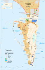
860:
841:
734:
683:
488:
429:
401:
390:
322:
219:
130:
80:
1855:
1803:
1456:Portal:Gibraltar/Selected picture
1326:Gibraltar Major Residential Areas
873:
506:Références complémentaires :
441:Map created using screenshots of
244:
131:
1574:Plantilya:Location map Gibraltar
1346:List of lighthouses in Gibraltar
1306:Detached Mole, Gibraltar Harbour
1138:coordinates of the point of view
1128:coordinates of the point of view
851:
801:Under the following conditions:
755:This file is licensed under the
747:
742:
736:
692:
691:
652:
629:
617:
605:
367:
353:
316:
253:
243:
190:
142:
132:
97:
31:
21:
1709:White Rock (bato sa Gyibraltar)
1471:Portal:Maps/Selected picture/31
1426:Knowledge:WikiProject Gibraltar
848:
430:
391:
1486:
1168:
847:
722:GNU Free Documentation License
711:GNU Free Documentation License
701:GNU Free Documentation License
489:
402:
177:it to a relevant article, and
26:
1:
1391:User talk:Jeff Dahl/Archive 4
1386:User talk:Jeff Dahl/Archive 2
1376:South Mole, Gibraltar Harbour
1361:North Mole, Gibraltar Harbour
536:Carte de localisation :
36:
1466:Portal:Maps/Selected picture
1296:
881:Items portrayed in this file
677:
667:. For more information see:
651:
552:Échelle approximative :
494:Création personnelle ;
7:
1793:
1570:Usage on ceb.wikipedia.org
1530:Usage on azb.wikipedia.org
1514:قالب:Location map Gibraltar
1153:36°7'59.999"N, 5°21'0.000"W
669:About translating SVG files
197:This image was selected as
10:
1860:
1560:Usage on bs.wikipedia.org
1550:Usage on bn.wikipedia.org
1540:Usage on bg.wikipedia.org
1520:Usage on av.wikipedia.org
1505:Usage on ar.wikipedia.org
1495:Usage on af.wikipedia.org
1289:Image:Gibraltar map-en.svg
815:same or compatible license
658:
437:Image:Gibraltar map-en.svg
386:Gibraltar map-en-edit2.svg
380:
282:suitable copyright license
230:
221:
1734:Saint Michael's Cave
1165:
575:), label/legend edits by
241:
237:
16:
1451:Template:POTD/2008-09-10
1336:Gibraltar Port Authority
1331:Gibraltar Nature Reserve
850:
781:
759:Attribution-Share Alike
706:Free Software Foundation
155:members of the community
104:This is a file from the
41:
1282:
1261:17:08, 10 December 2007
1252:
1231:18:52, 11 December 2007
1222:
659:This SVG file contains
571:Original by Eric Gaba (
527:Ministère de la Défense
418:
108:. Information from its
1287:|Source=adapted from:
476:(modified) created by
373:36.133333; -5.350000
111:description page there
1739:Saint Abb's Head
1476:Portal:United Kingdom
1356:Marina Bay, Gibraltar
1624:Gibraltar (pagklaro)
1341:Gibraltarian English
540:(modifiée) crée par
407:Carte en anglais de
169:it using the proper
74:1,000 × 1,558 pixels
70:1,314 × 2,048 pixels
1754:Mediterranean Steps
1201:16:36, 5 April 2017
796:– to adapt the work
153:, which means that
52:Other resolutions:
1759:Martin's Cave
1699:Great Europa Point
1381:User:Tyw7/picofday
665:SVG Translate tool
529:britannique ;
447:Other references:
396:Map in English of
209:September 10, 2008
200:picture of the day
66:657 × 1,024 pixels
1844:Maps of Gibraltar
1834:Featured pictures
1822:
1821:
1788:more global usage
1629:Rock of Gibraltar
1487:Global file usage
1366:Rock of Gibraltar
1294:
975:copyright license
941:copyright license
867:
859:
761:4.0 International
733:
732:
675:
674:
643:
642:
591:
588:Reusing this file
378:
377:
330:was created with
310:
309:
306:
305:
302:
301:
264:Featured pictures
215:
214:
205:English Knowledge
185:
184:
126:
125:
106:Wikimedia Commons
32:Global file usage
1851:
1804:
1729:Sandy Bay (luuk)
1694:Caledonian Canal
1684:Cerro de Enmedio
1664:Governor’s Beach
1273:
1243:
1213:
1175:
911:copyright status
897:copyright status
865:
861:Map of Gibraltar
857:
837:
834:
831:
828:
825:
817:as the original.
757:Creative Commons
751:
750:
746:
745:
740:
739:
729:
726:
723:
720:
717:
695:
694:
688:
656:
649:
633:
621:
609:
585:
493:
491:Français :
434:
421:
406:
404:Français :
395:
387:
381:
374:
371:
357:
356:
350:
349:
338:
320:
260:featured picture
258: This is a
257:
256:
247:
246:
235:
234:
231:
227:
194:
187:
171:free license tag
151:featured picture
146:
139:
136:
122:
101:
100:
94:
88:
77:
62:493 × 768 pixels
58:308 × 480 pixels
54:154 × 240 pixels
48:385 × 600 pixels
1859:
1858:
1854:
1853:
1852:
1850:
1849:
1848:
1824:
1823:
1792:
1724:Sandy Bay North
1485:
1295:
1279:
1271:
1249:
1241:
1219:
1211:
1167:
1166:
1163:
1162:
1161:
1160:
1159:
1158:
1157:
1156:
1154:
1144:
1143:
1142:
1140:
1125:
1124:
1123:
1122:
1121:
1120:
1119:
1118:
1116:
1106:
1105:
1104:
1102:
1087:
1086:
1085:
1084:
1083:
1082:
1081:
1080:
1078:
1067:
1066:
1065:
1064:
1063:
1061:
1050:
1049:
1048:
1047:
1046:
1044:
1033:
1032:
1031:
1030:
1029:
1027:
1016:
1015:
1014:
1013:
1012:
1010:
999:
998:
997:
996:
995:
993:
981:
980:
979:
977:
938:
937:
936:
935:
934:
933:
932:
931:
929:
917:
916:
915:
913:
894:
893:
892:
891:
890:
888:
872:
871:
870:
863:
862:
845:
844:
843:
839:
838:
835:
832:
829:
826:
823:
822:
780:
752:
727:
724:
721:
718:
715:
686:
685:
680:
644:
637:
634:
625:
622:
613:
610:
563:
520:Carte de Gibnet
514:Carte de la CIA
487:
411:
400:
385:
372:
345:
344:
341:Camera location
336:
335:
325:W3C-unspecified
311:
254:
224:
217:
216:
137:
128:
127:
116:
115:
114:is shown below.
90:
86:
79:
78:
51:
12:
11:
5:
1857:
1847:
1846:
1841:
1836:
1820:
1819:
1816:
1812:
1811:
1808:
1795:
1790:of this file.
1784:
1783:
1782:
1781:
1776:
1771:
1766:
1761:
1756:
1751:
1746:
1741:
1736:
1731:
1726:
1721:
1716:
1711:
1706:
1701:
1696:
1691:
1689:Blackstrap Bay
1686:
1681:
1676:
1671:
1666:
1661:
1656:
1651:
1646:
1641:
1636:
1634:Deadmans Beach
1631:
1626:
1621:
1616:
1611:
1606:
1601:
1596:
1591:
1586:
1581:
1576:
1568:
1567:
1566:
1558:
1557:
1556:
1548:
1547:
1546:
1538:
1537:
1536:
1528:
1527:
1526:
1518:
1517:
1516:
1511:
1503:
1502:
1501:
1488:
1484:
1483:
1478:
1473:
1468:
1463:
1458:
1453:
1448:
1443:
1438:
1433:
1428:
1423:
1418:
1413:
1408:
1403:
1398:
1393:
1388:
1383:
1378:
1373:
1368:
1363:
1358:
1353:
1348:
1343:
1338:
1333:
1328:
1323:
1318:
1313:
1308:
1298:
1293:
1292:
1281:
1277:
1274:
1270:1,200 × 1,870
1268:
1263:
1258:
1255:
1254:
1251:
1247:
1244:
1240:1,000 × 1,558
1238:
1233:
1228:
1225:
1224:
1221:
1217:
1214:
1210:1,000 × 1,558
1208:
1203:
1198:
1194:
1193:
1190:
1187:
1184:
1181:
1178:
1170:
1155:
1152:
1150:
1149:
1148:
1146:
1145:
1141:
1136:
1134:
1133:
1132:
1131:
1129:
1117:
1114:
1112:
1111:
1110:
1108:
1107:
1103:
1098:
1096:
1095:
1094:
1093:
1091:
1079:
1074:
1072:
1071:
1070:
1068:
1062:
1057:
1055:
1054:
1053:
1051:
1045:
1040:
1038:
1037:
1036:
1034:
1028:
1023:
1021:
1020:
1019:
1017:
1011:
1006:
1004:
1003:
1002:
1000:
994:
989:
987:
986:
985:
983:
982:
978:
973:
971:
970:
969:
968:
966:
962:
958:
954:
950:
946:
942:
930:
925:
923:
922:
921:
919:
918:
914:
909:
907:
906:
905:
904:
902:
898:
889:
884:
882:
879:
878:
877:
876:
864:
856:
855:
852:
849:
840:
821:
820:
819:
818:
808:
799:
798:
797:
791:
784:You are free:
754:
753:
735:
731:
730:
696:
682:
681:
679:
676:
673:
672:
657:
641:
640:
639:
638:
635:
628:
626:
623:
616:
614:
611:
604:
600:
599:Other versions
596:
595:
592:
580:
579:
569:
565:
564:
562:
561:
555:
548:
547:
546:
545:
533:
532:
531:
530:
523:
517:
508:
507:
504:
486:
485:
482:
469:
468:
467:
466:
461:
456:
435:adapted from:
427:
423:
422:
417:
413:
412:
388:
379:
376:
375:
365:
359:
342:
315:
308:
307:
304:
303:
300:
299:
250:
249:
240:
238:
223:
220:
213:
212:
195:
183:
182:
147:
124:
123:
102:
92:
91:
45:
40:
39:
34:
29:
24:
19:
9:
6:
4:
3:
2:
1856:
1845:
1842:
1840:
1837:
1835:
1832:
1831:
1829:
1817:
1814:
1813:
1809:
1806:
1805:
1802:
1799:
1791:
1789:
1780:
1777:
1775:
1772:
1770:
1767:
1765:
1762:
1760:
1757:
1755:
1752:
1750:
1747:
1745:
1742:
1740:
1737:
1735:
1732:
1730:
1727:
1725:
1722:
1720:
1717:
1715:
1712:
1710:
1707:
1705:
1702:
1700:
1697:
1695:
1692:
1690:
1687:
1685:
1682:
1680:
1679:Gibraltar Bay
1677:
1675:
1672:
1670:
1667:
1665:
1662:
1660:
1657:
1655:
1652:
1650:
1647:
1645:
1644:Western Beach
1642:
1640:
1639:Eastern Beach
1637:
1635:
1632:
1630:
1627:
1625:
1622:
1620:
1617:
1615:
1612:
1610:
1607:
1605:
1604:Passage Point
1602:
1600:
1597:
1595:
1592:
1590:
1587:
1585:
1582:
1580:
1577:
1575:
1572:
1571:
1569:
1565:
1562:
1561:
1559:
1555:
1552:
1551:
1549:
1545:
1542:
1541:
1539:
1535:
1532:
1531:
1529:
1525:
1522:
1521:
1519:
1515:
1512:
1510:
1509:صخرة جبل طارق
1507:
1506:
1504:
1500:
1497:
1496:
1494:
1493:
1492:
1482:
1479:
1477:
1474:
1472:
1469:
1467:
1464:
1462:
1459:
1457:
1454:
1452:
1449:
1447:
1444:
1442:
1439:
1437:
1434:
1432:
1429:
1427:
1424:
1422:
1419:
1417:
1414:
1412:
1409:
1407:
1404:
1402:
1399:
1397:
1394:
1392:
1389:
1387:
1384:
1382:
1379:
1377:
1374:
1372:
1369:
1367:
1364:
1362:
1359:
1357:
1354:
1352:
1349:
1347:
1344:
1342:
1339:
1337:
1334:
1332:
1329:
1327:
1324:
1322:
1319:
1317:
1314:
1312:
1309:
1307:
1304:
1303:
1302:
1290:
1286:
1280:
1275:
1269:
1267:
1264:
1262:
1259:
1257:
1256:
1250:
1245:
1239:
1237:
1234:
1232:
1229:
1227:
1226:
1220:
1215:
1209:
1207:
1204:
1202:
1199:
1196:
1195:
1191:
1188:
1185:
1182:
1179:
1177:
1176:
1174:
1151:
1139:
1135:
1115:November 2007
1113:
1101:
1097:
1077:
1073:
1060:
1056:
1043:
1039:
1026:
1022:
1009:
1005:
992:
988:
976:
972:
928:
924:
912:
908:
887:
883:
880:
853:
846:
827:CC BY-SA 4.0
816:
812:
809:
806:
803:
802:
800:
795:
792:
789:
786:
785:
783:
782:
778:
774:
770:
766:
762:
758:
741:
713:
712:
707:
703:
702:
697:
690:
689:
670:
666:
662:
655:
650:
647:
646:
632:
627:
620:
615:
608:
603:
602:
601:
597:
593:
589:
584:
581:
578:
574:
570:
566:
559:
556:
553:
550:
549:
543:
539:
535:
534:
528:
524:
521:
518:
515:
512:
511:
510:
509:
505:
502:
498:
497:
496:
495:
492:
483:
480:
479:
475:
472:Locator map:
471:
470:
465:
462:
460:
457:
455:
452:
451:
450:
449:
448:
446:
444:
440:
438:
433:
428:
424:
420:November 2007
414:
410:
405:
399:
394:
389:
382:
370:
366:
364:
363:OpenStreetMap
360:
358:
348:
343:
340:
339:
333:
329:
326:
319:
314:
313:
298:
297:
295:
291:
287:
284:, be sure to
283:
279:
277:
272:
271:
269:
265:
261:
252:
251:
248:
239:
236:
233:
232:
229:
228:
210:
206:
202:
201:
196:
193:
189:
188:
180:
176:
172:
168:
164:
163:
162:
156:
152:
148:
145:
141:
140:
135:
120:
113:
112:
107:
103:
96:
95:
89:
84:
83:Original file
75:
71:
67:
63:
59:
55:
49:
44:
38:
35:
33:
30:
28:
25:
23:
20:
18:
15:
1800:
1797:
1785:
1779:H.M.S. Rooke
1674:Europa Point
1654:Punta Europa
1649:Punta Pasaje
1490:
1300:
1172:
1169:File history
810:
804:
793:
787:
765:3.0 Unported
709:
699:
660:
645:
557:
551:
501:Google Earth
490:
464:U.K. MoD map
443:Google Earth
439:
431:
403:
392:
328:vector image
324:
312:
273:
259:
242:
198:
159:
158:
119:You can help
109:
81:
22:File history
1774:Levant Cave
1744:North Gorge
1619:Middle Hill
1599:Ailsa Craig
1594:Roca Blanca
1579:Signal Hill
1554:জিব্রাল্টার
927:copyrighted
901:copyrighted
811:share alike
805:attribution
777:1.0 Generic
773:2.0 Generic
769:2.5 Generic
558:Note :
542:Historicair
478:Historicair
384:Description
294:nominate it
276:nominate it
179:nominate it
1828:Categories
1704:Gibilterra
1584:White Rock
1534:جبل الطارق
1297:File usage
1186:Dimensions
583:Permission
459:Gibnet map
161:identified
149:This is a
27:File usage
1818:1558.2777
1589:Sandy Bay
1564:Gibraltar
1544:Гибралтар
1499:Gibraltar
1371:Rosia Bay
1316:Gibraltar
1285:Gibraltar
1278:Jeff Dahl
1272:(1.78 MB)
1248:Jeff Dahl
1242:(1.79 MB)
1212:(1.46 MB)
1183:Thumbnail
1180:Date/Time
1100:inception
1090:inception
678:Licensing
577:Jeff Dahl
525:Carte du
432:English:
409:Gibraltar
398:Gibraltar
393:English:
1794:Metadata
1769:The Lido
1669:Camp Bay
1614:The Rock
1609:El Peñón
854:Captions
794:to remix
788:to share
779:license.
332:Inkscape
292:it, and
37:Metadata
1659:La Roca
1351:Llanito
1197:current
1192:Comment
886:depicts
858:English
612:Spanish
544: ;
522: ;
516: ;
454:CIA map
222:Summary
203:on the
85:
1815:Height
866:Arabic
636:German
624:French
568:Author
426:Source
351:
321:
286:upload
167:upload
1807:Width
1786:View
1218:RaviC
573:Sting
323:This
157:have
1810:1000
1189:User
836:true
833:true
775:and
728:true
725:true
719:GFDL
416:Date
288:it,
268:here
207:for
17:File
290:tag
175:add
1830::
771:,
767:,
763:,
671:.
173:,
72:|
68:|
64:|
60:|
56:|
50:.
714:.
590:)
586:(
334:.
296:.
278:.
270:.
211:.
181:.
121:.
76:.
Text is available under the Creative Commons Attribution-ShareAlike License. Additional terms may apply.
