742:"}},"text\/plain":{"en":{"":"coordinates of the point of view"}}},"{\"value\":{\"latitude\":51.326197,\"longitude\":-1.361013,\"altitude\":null,\"precision\":1.0e-6,\"globe\":\"http:\\\/\\\/www.wikidata.org\\\/entity\\\/Q2\"},\"type\":\"globecoordinate\"}":{"text\/html":{"en":{"P1259":"51\u00b019'34.309"N, 1\u00b021'39.647"W"}},"text\/plain":{"en":{"P1259":"51\u00b019'34.309\"N, 1\u00b021'39.647\"W"}}},"{\"value\":{\"entity-type\":\"property\",\"numeric-id\":7787,\"id\":\"P7787\"},\"type\":\"wikibase-entityid\"}":{"text\/html":{"en":{"":"
585:"}},"text\/plain":{"en":{"":"inception"}}},"{\"value\":{\"time\":\"+2008-07-30T00:00:00Z\",\"timezone\":0,\"before\":0,\"after\":0,\"precision\":11,\"calendarmodel\":\"http:\\\/\\\/www.wikidata.org\\\/entity\\\/Q1985727\"},\"type\":\"time\"}":{"text\/html":{"en":{"P571":"30 July 2008"}},"text\/plain":{"en":{"P571":"30 July 2008"}}}}": -->
619:
386:
738:
203:
222:
260:
265:
67:
406:"}},"text\/plain":{"en":{"P2699":"https:\/\/www.geograph.org.uk\/profile\/10423"}}},"{\"value\":{\"entity-type\":\"property\",\"numeric-id\":2093,\"id\":\"P2093\"},\"type\":\"wikibase-entityid\"}":{"text\/html":{"en":{"":"
635:"}},"text\/plain":{"en":{"P973":"https:\/\/www.geograph.org.uk\/photo\/905694"}}},"{\"value\":{\"entity-type\":\"property\",\"numeric-id\":7384,\"id\":\"P7384\"},\"type\":\"wikibase-entityid\"}":{"text\/html":{"en":{"":"
627:"}},"text\/plain":{"en":{"P7482":"file available on the internet"}}},"{\"value\":{\"entity-type\":\"property\",\"numeric-id\":973,\"id\":\"P973\"},\"type\":\"wikibase-entityid\"}":{"text\/html":{"en":{"":"
410:"}},"text\/plain":{"en":{"":"author name string"}}},"{\"value\":\"Mike Searle\",\"type\":\"string\"}":{"text\/html":{"en":{"P2093":"Mike Searle"}},"text\/plain":{"en":{"P2093":"Mike Searle"}}}}": -->
394:"}},"text\/plain":{"en":{"":"object of statement has role"}}},"{\"value\":{\"entity-type\":\"item\",\"numeric-id\":33231,\"id\":\"Q33231\"},\"type\":\"wikibase-entityid\"}":{"text\/html":{"en":{"P3831":"
541:"}},"text\/plain":{"en":{"":"copyright license"}}},"{\"value\":{\"entity-type\":\"item\",\"numeric-id\":19068220,\"id\":\"Q19068220\"},\"type\":\"wikibase-entityid\"}":{"text\/html":{"en":{"P275":"
497:"}},"text\/plain":{"en":{"":"copyright status"}}},"{\"value\":{\"entity-type\":\"item\",\"numeric-id\":50423863,\"id\":\"Q50423863\"},\"type\":\"wikibase-entityid\"}":{"text\/html":{"en":{"P6216":"
623:"}},"text\/plain":{"en":{"":"source of file"}}},"{\"value\":{\"entity-type\":\"item\",\"numeric-id\":74228490,\"id\":\"Q74228490\"},\"type\":\"wikibase-entityid\"}":{"text\/html":{"en":{"P7482":"
398:"}},"text\/plain":{"en":{"P3831":"photographer"}}},"{\"value\":{\"entity-type\":\"property\",\"numeric-id\":2699,\"id\":\"P2699\"},\"type\":\"wikibase-entityid\"}":{"text\/html":{"en":{"":"
746:"}},"text\/plain":{"en":{"":"heading"}}},"{\"value\":{\"amount\":\"+315\",\"unit\":\"http:\\\/\\\/www.wikidata.org\\\/entity\\\/Q28390\"},\"type\":\"quantity\"}":{"text\/html":{"en":{"P7787":"315
647:"}},"text\/plain":{"en":{"":"operator"}}},"{\"value\":{\"entity-type\":\"item\",\"numeric-id\":1503119,\"id\":\"Q1503119\"},\"type\":\"wikibase-entityid\"}":{"text\/html":{"en":{"P137":"
643:"}},"text\/plain":{"en":{"P7384":"905694"}}},"{\"value\":{\"entity-type\":\"property\",\"numeric-id\":137,\"id\":\"P137\"},\"type\":\"wikibase-entityid\"}":{"text\/html":{"en":{"":"
390:"}},"text\/plain":{"en":{"":"creator"}}},"{\"value\":{\"entity-type\":\"property\",\"numeric-id\":3831,\"id\":\"P3831\"},\"type\":\"wikibase-entityid\"}":{"text\/html":{"en":{"":"
493:
402:"}},"text\/plain":{"en":{"":"URL"}}},"{\"value\":\"https:\\\/\\\/www.geograph.org.uk\\\/profile\\\/10423\",\"type\":\"string\"}":{"text\/html":{"en":{"P2699":"
639:"}},"text\/plain":{"en":{"":"geograph.org.uk image ID"}}},"{\"value\":\"905694\",\"type\":\"string\"}":{"text\/html":{"en":{"P7384":"
38:
312:– You must give appropriate credit, provide a link to the license, and indicate if changes were made. You may do so in any reasonable manner, but not in any way that suggests the licensor endorses you or your use.
186:
172:
640:
624:
542:
498:
648:
395:
743:
739:
636:
620:
494:
407:
399:
391:
403:
644:
632:
628:
582:
538:
387:
858:
932:
865:{{Information |Description=Highclere Castle |Source=From |Date=2008-07-30 |Author= |Permission=Creative Commons Attribution Share-alike license
545:"}},"text\/plain":{"en":{"P275":"Creative Commons Attribution-ShareAlike 2.0 Generic"}}}}": -->
150:
674:
568:
524:
196:
957:
724:
229:
319:
78:
451:
46:
784:
757:
702:
658:
508:
474:
459:
444:
899:
717:
687:
592:
552:
417:
376:
651:"}},"text\/plain":{"en":{"P137":"Geograph Britain and Ireland"}}}}": -->
275:
318:– If you remix, transform, or build upon the material, you must distribute your contributions under the
236:
on the
Geograph website for the photographer's contact details. The copyright on this image is owned by
904:
501:"}},"text\/plain":{"en":{"P6216":"copyrighted"}}}}": -->
750:"}},"text\/plain":{"en":{"P7787":"315 degree"}}}}": -->
86:
933:
Knowledge:Technische Wünsche/Topwünsche/Bessere
Unterstützung von Geoinformationen/Kartographer
466:
709:
694:
272:
8:
847:
842:
37:
216:
889:
202:
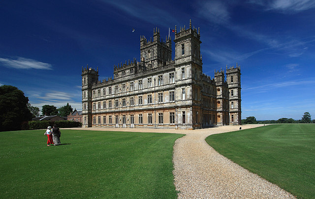
241:
73:
366:
894:
884:
937:
879:
139:
129:
767:
668:
602:
562:
518:
427:
221:
233:
815:
Click on a date/time to view the file as it appeared at that time.
947:
922:
188:
173:
51° 19′ 34.31″ N, 1° 21′ 39.65″ W
118:
61:
360:
Add a one-line explanation of what this file represents
873:
913:
813:
157:
Creative
Commons Attribution Share-alike license 2.0
85:
Commons is a freely licensed media file repository.
569:
Creative
Commons Attribution-ShareAlike 2.0 Generic
543:
Creative
Commons Attribution-ShareAlike 2.0 Generic
51:(640 × 404 pixels, file size: 83 KB, MIME type:
329:https://creativecommons.org/licenses/by-sa/2.0
66:
404:https:\/\/www.geograph.org.uk\/profile\/10423
335:Creative Commons Attribution-Share Alike 2.0
253:
145:
114:
103:
633:https:\/\/www.geograph.org.uk\/photo\/905694
135:
124:
14:
747:
295:– to copy, distribute and transmit the work
915:The following other wikis use this file:
467:https://www.geograph.org.uk/profile/10423
695:https://www.geograph.org.uk/photo/905694
195:View this and other nearby images on:
875:The following 6 pages use this file:
97:
240:and is licensed for reuse under the
163:
938:Knowledge:Kartensaison/Kartographer
806:
276:Attribution-Share Alike 2.0 Generic
264:
259:
244:Attribution-ShareAlike 2.0 license.
13:
900:Portal:Hampshire/Selected pictures
365:
359:
250:
227:
98:
44:
971:
364:
758:coordinates of the point of view
740:coordinates of the point of view
350:
306:Under the following conditions:
271:This file is licensed under the
263:
258:
252:
220:
201:
187:
179:
65:
31:
21:
347:
41:No higher resolution available.
910:
810:
675:file available on the internet
625:file available on the internet
346:
228:This image was taken from the
26:
1:
773:51°19'34.309"N, 1°21'39.647"W
870:
725:Geograph Britain and Ireland
649:Geograph Britain and Ireland
445:object of statement has role
392:object of statement has role
372:Items portrayed in this file
178:
7:
10:
976:
954:Usage on ja.wikipedia.org
944:Usage on es.wikipedia.org
929:Usage on de.wikipedia.org
919:Usage on ca.wikipedia.org
320:same or compatible license
100:
905:Portal:South East England
807:
16:
703:geograph.org.uk image ID
637:geograph.org.uk image ID
349:
286:
72:This is a file from the
36:
864:
117:
106:Highclere Castle 02.jpg
76:. Information from its
47:Highclere_Castle_02.jpg
234:this photograph's page
207:51.326197; -1.361013
79:description page there
948:Castillo de Highclere
843:22:17, 24 August 2008
923:Castell de Highclere
301:– to adapt the work
890:User:Cnbrb/Sandbox
475:author name string
408:author name string
911:Global file usage
868:
860:Kurpfalzbilder.de
749:
553:copyright license
539:copyright license
358:
249:
248:
232:collection. See
212:
211:
161:
160:
154:
151:Reusing this file
94:
93:
74:Wikimedia Commons
32:Global file usage
967:
895:Portal:Hampshire
885:Highclere Castle
855:
817:
795:
794:
789:
727:
722:
712:
707:
697:
692:
688:described at URL
629:described at URL
509:copyright status
495:copyright status
482:
479:
469:
464:
454:
449:
356:
342:
339:
336:
333:
330:
322:as the original.
284:
273:Creative Commons
267:
266:
262:
261:
256:
255:
242:Creative Commons
230:Geograph project
224:
217:
208:
205:
191:
190:
184:
183:
182:
176:
175:
164:
148:
120:
110:Highclere Castle
107:
101:
90:
69:
68:
62:
56:
54:
975:
974:
970:
969:
968:
966:
965:
964:
909:
869:
861:
853:
809:
808:
805:
804:
803:
802:
801:
800:
799:
798:
797:
796:
792:
790:
787:
778:
777:
776:
774:
764:
763:
762:
760:
737:
736:
735:
734:
733:
732:
731:
730:
729:
728:
723:
720:
714:
713:
708:
705:
699:
698:
693:
690:
681:
680:
679:
677:
665:
664:
663:
661:
618:
617:
616:
615:
614:
613:
612:
611:
609:
599:
598:
597:
595:
580:
579:
578:
577:
576:
575:
574:
573:
571:
559:
558:
557:
555:
536:
535:
534:
533:
532:
531:
530:
529:
527:
515:
514:
513:
511:
492:
491:
490:
489:
488:
487:
486:
485:
484:
483:
480:
477:
471:
470:
465:
462:
456:
455:
450:
447:
438:
437:
436:
434:
424:
423:
422:
420:
385:
384:
383:
382:
381:
379:
363:
362:
361:
344:
343:
340:
337:
334:
331:
328:
327:
285:
282:
279:
268:
245:
206:
180:
171:
170:
167:Camera location
162:
130:geograph.org.uk
105:
96:
95:
84:
83:
82:is shown below.
58:
52:
50:
43:
42:
12:
11:
5:
973:
963:
962:
961:
960:
952:
951:
950:
942:
941:
940:
935:
927:
926:
925:
912:
908:
907:
902:
897:
892:
887:
882:
872:
867:
866:
863:
859:
856:
850:
845:
840:
836:
835:
832:
829:
826:
823:
820:
812:
783:
782:
781:
780:
779:
775:
772:
770:
769:
768:
766:
765:
761:
756:
754:
753:
752:
751:
745:
741:
716:
715:
701:
700:
686:
685:
684:
683:
682:
678:
673:
671:
670:
669:
667:
666:
662:
659:source of file
657:
655:
654:
653:
652:
650:
646:
642:
638:
634:
630:
626:
622:
621:source of file
610:
607:
605:
604:
603:
601:
600:
596:
591:
589:
588:
587:
586:
584:
572:
567:
565:
564:
563:
561:
560:
556:
551:
549:
548:
547:
546:
544:
540:
528:
523:
521:
520:
519:
517:
516:
512:
507:
505:
504:
503:
502:
500:
496:
473:
472:
458:
457:
443:
442:
441:
440:
439:
435:
432:
430:
429:
428:
426:
425:
421:
416:
414:
413:
412:
411:
409:
405:
401:
397:
393:
389:
380:
375:
373:
370:
369:
368:
367:
355:
354:
351:
348:
326:
325:
324:
323:
313:
304:
303:
302:
296:
289:You are free:
280:
270:
269:
251:
247:
246:
225:
210:
209:
199:
193:
168:
159:
158:
155:
143:
142:
137:
133:
132:
126:
122:
121:
116:
112:
111:
108:
99:
92:
91:
70:
60:
59:
40:
35:
34:
29:
24:
19:
9:
6:
4:
3:
2:
972:
959:
956:
955:
953:
949:
946:
945:
943:
939:
936:
934:
931:
930:
928:
924:
921:
920:
918:
917:
916:
906:
903:
901:
898:
896:
893:
891:
888:
886:
883:
881:
880:Downton Abbey
878:
877:
876:
862:
857:
851:
849:
846:
844:
841:
838:
837:
833:
830:
827:
824:
821:
819:
818:
816:
786:
771:
759:
755:
726:
719:
711:
704:
696:
689:
676:
672:
660:
656:
606:
594:
590:
570:
566:
554:
550:
526:
522:
510:
506:
476:
468:
461:
453:
446:
431:
419:
415:
378:
374:
371:
352:
345:
332:CC BY-SA 2.0
321:
317:
314:
311:
308:
307:
305:
300:
297:
294:
291:
290:
288:
287:
281:Attribution:
277:
274:
257:
243:
239:
235:
231:
226:
223:
219:
218:
215:
214:
204:
200:
198:
197:OpenStreetMap
194:
192:
174:
169:
166:
165:
156:
152:
147:
144:
141:
138:
134:
131:
127:
123:
113:
109:
102:
88:
81:
80:
75:
71:
64:
63:
57:
48:
39:
33:
30:
28:
25:
23:
20:
18:
15:
914:
874:
814:
811:File history
608:30 July 2008
452:photographer
396:photographer
315:
309:
298:
292:
237:
213:
177:
119:30 July 2008
87:You can help
77:
45:
22:File history
525:copyrighted
499:copyrighted
481:Mike Searle
316:share alike
310:attribution
283:Mike Searle
238:Mike Searle
140:Mike Searle
104:Description
871:File usage
852:640 × 404
828:Dimensions
433:some value
146:Permission
53:image/jpeg
27:File usage
958:ダウントン・アビー
825:Thumbnail
822:Date/Time
593:inception
583:inception
718:operator
645:operator
353:Captions
299:to remix
293:to share
278:license.
854:(83 KB)
839:current
834:Comment
785:heading
744:heading
418:creator
388:creator
377:depicts
357:English
49:
793:degree
748:degree
710:905694
641:905694
185:
136:Author
125:Source
128:From
831:User
791:315
341:true
338:true
115:Date
17:File
460:URL
400:URL
788::
721::
706::
691::
478::
463::
448::
153:)
149:(
89:.
55:)
