611:"}},"text\/plain":{"en":{"":"coordinates of the point of view"}}},"{\"value\":{\"latitude\":36.5598,\"longitude\":-118.565086,\"altitude\":null,\"precision\":1.0e-6,\"globe\":\"http:\\\/\\\/www.wikidata.org\\\/entity\\\/Q2\"},\"type\":\"globecoordinate\"}":{"text\/html":{"en":{"P1259":"36\u00b033'35.280"N, 118\u00b033'54.310"W"}},"text\/plain":{"en":{"P1259":"36\u00b033'35.280\"N, 118\u00b033'54.310\"W"}}},"{\"value\":{\"entity-type\":\"property\",\"numeric-id\":7787,\"id\":\"P7787\"},\"type\":\"wikibase-entityid\"}":{"text\/html":{"en":{"":"
485:"}},"text\/plain":{"en":{"":"inception"}}},"{\"value\":{\"time\":\"+2006-08-03T00:00:00Z\",\"timezone\":0,\"before\":0,\"after\":0,\"precision\":11,\"calendarmodel\":\"http:\\\/\\\/www.wikidata.org\\\/entity\\\/Q1985727\"},\"type\":\"time\"}":{"text\/html":{"en":{"P571":"3 August 2006"}},"text\/plain":{"en":{"P571":"3 August 2006"}}}}": -->
281:
242:
607:
43:
256:
287:
103:
441:"}},"text\/plain":{"en":{"":"copyright license"}}},"{\"value\":{\"entity-type\":\"item\",\"numeric-id\":14947546,\"id\":\"Q14947546\"},\"type\":\"wikibase-entityid\"}":{"text\/html":{"en":{"P275":"
397:"}},"text\/plain":{"en":{"":"copyright status"}}},"{\"value\":{\"entity-type\":\"item\",\"numeric-id\":50423863,\"id\":\"Q50423863\"},\"type\":\"wikibase-entityid\"}":{"text\/html":{"en":{"P6216":"
567:"}},"text\/plain":{"en":{"":"source of file"}}},"{\"value\":{\"entity-type\":\"item\",\"numeric-id\":66458942,\"id\":\"Q66458942\"},\"type\":\"wikibase-entityid\"}":{"text\/html":{"en":{"P7482":"
523:"}},"text\/plain":{"en":{"":"captured with"}}},"{\"value\":{\"entity-type\":\"item\",\"numeric-id\":64061,\"id\":\"Q64061\"},\"type\":\"wikibase-entityid\"}":{"text\/html":{"en":{"P4082":"
615:"}},"text\/plain":{"en":{"":"heading"}}},"{\"value\":{\"amount\":\"+315\",\"unit\":\"http:\\\/\\\/www.wikidata.org\\\/entity\\\/Q28390\"},\"type\":\"quantity\"}":{"text\/html":{"en":{"P7787":"315
563:
1042:
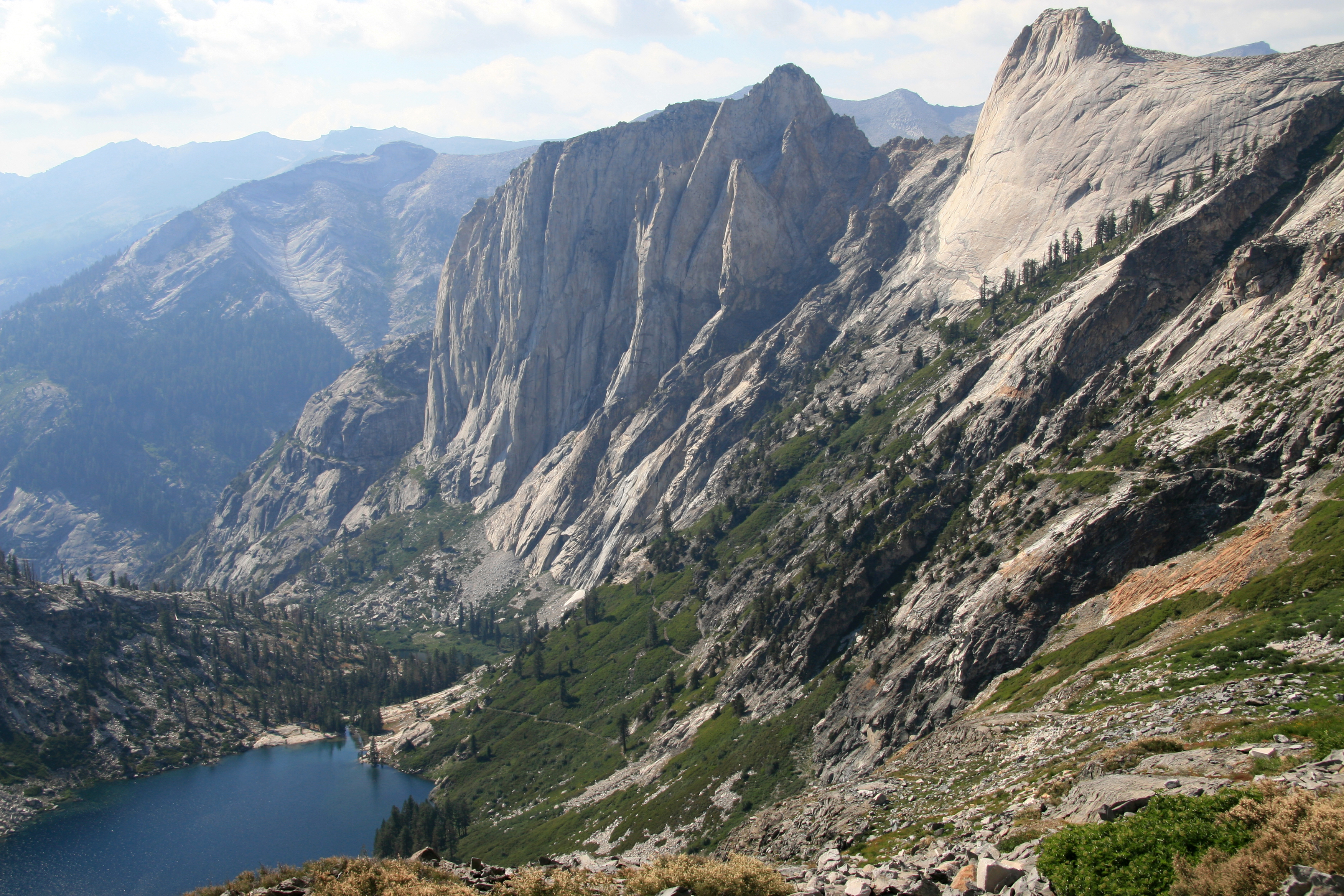
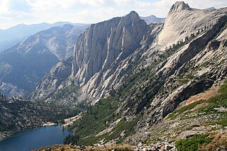
734:{{Information |Description={{en|1=View looking down valley from the bowl under Kaweah Gap. Shows Hamilton Lake, the Valhalla cliffs, and the High Sierra Trail switchbacking up.}} |Source=Own work by uploader |Author=
328:– You must give appropriate credit, provide a link to the license, and indicate if changes were made. You may do so in any reasonable manner, but not in any way that suggests the licensor endorses you or your use.
239:
225:
568:
442:
398:
1290:
1220:
524:
612:
608:
564:
520:
394:
482:
438:
842:
1210:
1260:
1177:
1167:
1117:
1187:
1172:
1162:
1112:
1182:
1097:
777:
872:
445:"}},"text\/plain":{"en":{"P275":"Creative Commons Attribution 3.0 Unported"}}}}": -->
594:
468:
424:
249:
1323:
This file contains additional information, probably added from the digital camera or scanner used to create or digitize it.
837:
787:
550:
69:
65:
61:
57:
53:
47:
822:
653:
626:
578:
534:
408:
571:"}},"text\/plain":{"en":{"P7482":"original creation by uploader"}}}}": -->
114:
492:
452:
383:
82:
1082:
1460:
1192:
1429:
1067:
867:
207:
1326:
If the file has been modified from its original state, some details may not fully reflect the modified file.
997:
297:
1022:
1017:
982:
797:
792:
757:
527:"}},"text\/plain":{"en":{"P4082":"Canon EOS 30D"}}}}": -->
401:"}},"text\/plain":{"en":{"P6216":"copyrighted"}}}}": -->
619:"}},"text\/plain":{"en":{"P7787":"315 degree"}}}}": -->
1107:
927:
122:
942:
817:
158:
1518:
1077:
957:
1057:
847:
294:
1087:
8:
1538:
1132:
937:
1122:
967:
932:
912:
902:
716:
711:
255:
165:. Shows Hamilton Lake, the Valhalla cliffs, and the High Sierra Trail switchbacking up.
73:
42:
1270:
1152:
1137:
1127:
1047:
862:
762:
198:
109:
1043:
National
Register of Historic Places listings in Sequoia-Kings Canyon National Parks
373:
274:
I, the copyright holder of this work, hereby publish it under the following license:
1157:
1142:
1052:
947:
827:
1335:
1310:
962:
882:
807:
1102:
1092:
952:
892:
857:
812:
1606:
1528:
1500:
1352:
1345:
1280:
1072:
1032:
1027:
1002:
992:
897:
802:
367:
Looking down at
Hamilton Lake from the High Sierra Trail near the Kaweah Gap.
1250:
1392:
1007:
987:
972:
922:
917:
887:
832:
782:
767:
194:
1556:
772:
735:
727:
636:
588:
544:
502:
462:
418:
162:
1372:
1062:
1037:
1012:
907:
852:
1300:
977:
877:
752:
1362:
684:
Click on a date/time to view the file as it appeared at that time.
1455:
Landscape mode (for landscape photos with the background in focus)
226:
36° 33′ 35.28″ N, 118° 33′ 54.31″ W
1240:
241:
1147:
1230:
174:
157:
View looking down valley from the bowl under Kaweah Gap,
97:
87:(3,504 × 2,336 pixels, file size: 5.74 MB, MIME type:
746:
1201:
682:
121:
Commons is a freely licensed media file repository.
843:Giant Forest Village–Camp Kaweah Historic District
1543:Flash did not fire, compulsory flash suppression
1178:Knowledge:Main Page history/2024 September 25b
1168:Knowledge:Main Page history/2023 September 25b
1118:Triple Divide Peak (Tulare County, California)
102:
1188:Knowledge:Selected anniversaries/September 25
1173:Knowledge:Main Page history/2024 September 25
1163:Knowledge:Main Page history/2023 September 25
280:
170:
144:
1113:Thunder Mountain (Tulare County, California)
190:
180:
14:
616:
335:https://creativecommons.org/licenses/by/3.0
311:– to copy, distribute and transmit the work
1183:Knowledge:Selected anniversaries/September
1098:Table Mountain (Tulare County, California)
778:Cabin Creek Ranger Residence and Dormitory
1203:The following other wikis use this file:
469:Creative Commons Attribution 3.0 Unported
443:Creative Commons Attribution 3.0 Unported
873:Hospital Rock (Three Rivers, California)
748:The following 89 pages use this file:
248:View this and other nearby images on:
133:
838:Giant Forest Lodge Historic District
823:Generals' Highway Stone Bridges
788:Crystal Cave (Sequoia National Park)
216:
675:
286:
13:
1321:
372:
366:
302:
277:
273:
151:
134:
80:
1726:
1328:
371:
341:Creative Commons Attribution 3.0
1383:Date and time of data generation
627:coordinates of the point of view
609:coordinates of the point of view
357:
322:Under the following conditions:
293:This file is licensed under the
285:
279:
254:
240:
232:
101:
31:
21:
1682:Date metadata was last modified
1083:Smithsonian Institution Shelter
642:36°33'35.280"N, 118°33'54.310"W
354:
152:
1198:
1193:Template:Sequoia National Park
679:
353:
26:
1:
1430:Adobe Photoshop CS2 Macintosh
1068:Redwood Meadow Ranger Station
868:Hockett Meadow Ranger Station
595:original creation by uploader
569:original creation by uploader
36:
743:
379:Items portrayed in this file
267:
231:
7:
1582:Focal plane resolution unit
1471:Date and time of digitizing
1318:
1281:Sekvojų nacionalinis parkas
998:Mount Le Conte (California)
10:
1731:
1658:Supported Flashpix version
1548:Supported Flashpix version
1307:Usage on zh.wikipedia.org
1297:Usage on tr.wikipedia.org
1287:Usage on mk.wikipedia.org
1277:Usage on lt.wikipedia.org
1267:Usage on is.wikipedia.org
1257:Usage on he.wikipedia.org
1247:Usage on fr.wikipedia.org
1237:Usage on ca.wikipedia.org
1227:Usage on br.wikipedia.org
1217:Usage on bg.wikipedia.org
1207:Usage on ar.wikipedia.org
1023:Mount Stewart (California)
1018:Mount Russell (California)
983:Mount Barnard (California)
798:Florence Peak (California)
793:Eagle Lake (Tulare County)
758:Ash Mountain Entrance Sign
141:
136:
1479:Meaning of each component
1436:File change date and time
676:
184:
16:
1574:Focal plane Y resolution
1566:Focal plane X resolution
1221:Секвоя (национален парк)
1108:Three Rivers, California
356:
298:Attribution 3.0 Unported
108:This is a file from the
41:
1685:19:19, 20 November 2006
1590:Custom image processing
1439:00:19, 21 November 2006
1291:Национален парк Секвоја
928:Kern Plateau salamander
733:
173:
112:. Information from its
943:Lemon Cove, California
818:General Sherman (tree)
712:00:34, 26 January 2009
260:36.559800; -118.565086
115:description page there
46:Size of this preview:
1410:Horizontal resolution
1271:Sequoia-þjóðgarðurinn
1251:Cordillère américaine
1211:سلسلة جبال غرب أمريكا
1088:Squatter's Cabin
1078:Sequoia National Park
958:Lone Pine, California
159:Sequoia National Park
147:Kaweah downValley.jpg
1474:19:15, 3 August 2006
1386:19:15, 3 August 2006
1058:Quinn Ranger Station
848:Great Western Divide
74:3,504 × 2,336 pixels
70:2,560 × 1,707 pixels
1444:Y and C positioning
1418:Vertical resolution
1332:Camera manufacturer
1301:Sekoya Ulusal Parkı
1261:הקורדילרה האמריקנית
1241:Serralada americana
1133:Visalia, California
938:Kings-Kaweah Divide
317:– to adapt the work
52:Other resolutions:
1640:Bits per component
1616:Scene capture type
1611:Auto white balance
1123:Tulare, California
968:Milestone Mountain
933:King Arthur (tree)
913:Kaweah Peaks Ridge
903:Kaweah, California
195:Jane S. Richardson
66:1,280 × 853 pixels
62:1,024 × 683 pixels
1718:
1717:
1357:1/200 sec (0.005)
1231:Aradennad Amerika
1199:Global file usage
1153:Talk:September 25
1138:Washington (tree)
1128:Ursa Minor (cave)
1048:Pear Lake Ski Hut
863:High Sierra Trail
763:Atwell Mill Grove
741:
618:
453:copyright license
439:copyright license
365:
265:
264:
214:
213:
130:
129:
110:Wikimedia Commons
32:Global file usage
1722:
1701:HighSierra trail
1698:hike-MineralKing
1577:3,959.3220338983
1569:3,959.3220338983
1452:Exposure Program
1329:
1158:User:Holly Cheng
1143:Wuksachi Village
1103:Tharp's Log
1053:President (tree)
948:Lilliput Glacier
828:Generals Highway
724:
686:
664:
663:
658:
409:copyright status
395:copyright status
363:
348:
345:
342:
339:
336:
295:Creative Commons
289:
288:
283:
282:
261:
258:
244:
243:
237:
236:
235:
229:
228:
217:
206:
205:
186:
176:
156:
148:
142:
126:
105:
104:
98:
92:
90:
77:
58:640 × 427 pixels
54:320 × 213 pixels
48:800 × 533 pixels
1730:
1729:
1725:
1724:
1723:
1721:
1720:
1719:
1513:6.6438598632812
1505:7.6438598632812
1317:
1197:
963:Mark Twain Tree
883:John Muir Trail
808:Franklin (tree)
742:
738:|Date=August 3,
730:
722:
678:
677:
674:
673:
672:
671:
670:
669:
668:
667:
666:
665:
661:
659:
656:
647:
646:
645:
643:
633:
632:
631:
629:
606:
605:
604:
603:
602:
601:
600:
599:
597:
585:
584:
583:
581:
562:
561:
560:
559:
558:
557:
556:
555:
553:
541:
540:
539:
537:
518:
517:
516:
515:
514:
513:
512:
511:
509:
499:
498:
497:
495:
480:
479:
478:
477:
476:
475:
474:
473:
471:
459:
458:
457:
455:
436:
435:
434:
433:
432:
431:
430:
429:
427:
415:
414:
413:
411:
392:
391:
390:
389:
388:
386:
370:
369:
368:
351:
350:
349:
346:
343:
340:
337:
334:
333:
301:
290:
276:
275:
270:
259:
233:
224:
223:
220:Camera location
215:
203:
201:
166:
146:
139:
132:
131:
120:
119:
118:is shown below.
94:
88:
86:
79:
78:
51:
12:
11:
5:
1728:
1716:
1715:
1712:
1708:
1707:
1706:
1705:
1702:
1699:
1696:
1691:
1687:
1686:
1683:
1679:
1678:
1675:
1671:
1670:
1667:
1663:
1662:
1659:
1655:
1654:
1653:
1652:
1649:
1646:
1641:
1637:
1636:
1633:
1629:
1628:
1625:
1621:
1620:
1617:
1613:
1612:
1609:
1603:
1602:
1599:
1595:
1594:
1593:Normal process
1591:
1587:
1586:
1583:
1579:
1578:
1575:
1571:
1570:
1567:
1563:
1562:
1559:
1553:
1552:
1549:
1545:
1544:
1541:
1535:
1534:
1531:
1525:
1524:
1521:
1515:
1514:
1511:
1507:
1506:
1503:
1497:
1496:
1495:
1494:
1493:does not exist
1491:
1488:
1485:
1480:
1476:
1475:
1472:
1468:
1467:
1464:
1457:
1456:
1453:
1449:
1448:
1445:
1441:
1440:
1437:
1433:
1432:
1427:
1423:
1422:
1419:
1415:
1414:
1411:
1407:
1406:
1403:
1399:
1398:
1395:
1388:
1387:
1384:
1380:
1379:
1376:
1369:
1368:
1365:
1359:
1358:
1355:
1349:
1348:
1343:
1339:
1338:
1333:
1320:
1316:
1315:
1314:
1313:
1305:
1304:
1303:
1295:
1294:
1293:
1285:
1284:
1283:
1275:
1274:
1273:
1265:
1264:
1263:
1255:
1254:
1253:
1245:
1244:
1243:
1235:
1234:
1233:
1225:
1224:
1223:
1215:
1214:
1213:
1200:
1196:
1195:
1190:
1185:
1180:
1175:
1170:
1165:
1160:
1155:
1150:
1145:
1140:
1135:
1130:
1125:
1120:
1115:
1110:
1105:
1100:
1095:
1093:Stephen Mather
1090:
1085:
1080:
1075:
1070:
1065:
1060:
1055:
1050:
1045:
1040:
1035:
1030:
1025:
1020:
1015:
1010:
1005:
1000:
995:
990:
985:
980:
975:
970:
965:
960:
955:
953:Lincoln (tree)
950:
945:
940:
935:
930:
925:
920:
915:
910:
905:
900:
895:
893:Josiah Whitney
890:
885:
880:
875:
870:
865:
860:
858:Hazelwood Tree
855:
850:
845:
840:
835:
830:
825:
820:
815:
813:Garfield Grove
810:
805:
800:
795:
790:
785:
780:
775:
770:
765:
760:
755:
745:
740:
739:
732:
728:
725:
721:3,504 × 2,336
719:
714:
709:
705:
704:
701:
698:
695:
692:
689:
681:
652:
651:
650:
649:
648:
644:
641:
639:
638:
637:
635:
634:
630:
625:
623:
622:
621:
620:
614:
610:
598:
593:
591:
590:
589:
587:
586:
582:
579:source of file
577:
575:
574:
573:
572:
570:
566:
565:source of file
554:
549:
547:
546:
545:
543:
542:
538:
533:
531:
530:
529:
528:
526:
522:
510:
507:
505:
504:
503:
501:
500:
496:
491:
489:
488:
487:
486:
484:
472:
467:
465:
464:
463:
461:
460:
456:
451:
449:
448:
447:
446:
444:
440:
428:
423:
421:
420:
419:
417:
416:
412:
407:
405:
404:
403:
402:
400:
396:
387:
382:
380:
377:
376:
375:
374:
362:
361:
358:
355:
332:
331:
330:
329:
320:
319:
318:
312:
305:You are free:
292:
291:
278:
272:
271:
269:
266:
263:
262:
252:
246:
221:
212:
211:
192:
188:
187:
182:
178:
177:
172:
168:
167:
149:
140:
138:
135:
128:
127:
106:
96:
95:
45:
40:
39:
34:
29:
24:
19:
9:
6:
4:
3:
2:
1727:
1713:
1710:
1709:
1703:
1700:
1697:
1694:
1693:
1692:
1689:
1688:
1684:
1681:
1680:
1676:
1673:
1672:
1668:
1665:
1664:
1660:
1657:
1656:
1650:
1647:
1644:
1643:
1642:
1639:
1638:
1634:
1631:
1630:
1626:
1623:
1622:
1618:
1615:
1614:
1610:
1608:
1607:White balance
1605:
1604:
1601:Auto exposure
1600:
1598:Exposure mode
1597:
1596:
1592:
1589:
1588:
1584:
1581:
1580:
1576:
1573:
1572:
1568:
1565:
1564:
1560:
1558:
1555:
1554:
1550:
1547:
1546:
1542:
1540:
1537:
1536:
1532:
1530:
1529:Metering mode
1527:
1526:
1522:
1520:
1519:Exposure bias
1517:
1516:
1512:
1510:APEX aperture
1509:
1508:
1504:
1502:
1501:Shutter speed
1499:
1498:
1492:
1489:
1486:
1483:
1482:
1481:
1478:
1477:
1473:
1470:
1469:
1465:
1462:
1459:
1458:
1454:
1451:
1450:
1446:
1443:
1442:
1438:
1435:
1434:
1431:
1428:
1426:Software used
1425:
1424:
1420:
1417:
1416:
1412:
1409:
1408:
1404:
1401:
1400:
1396:
1394:
1390:
1389:
1385:
1382:
1381:
1377:
1374:
1371:
1370:
1366:
1364:
1361:
1360:
1356:
1354:
1353:Exposure time
1351:
1350:
1347:
1346:Canon EOS 30D
1344:
1341:
1340:
1337:
1334:
1331:
1330:
1327:
1324:
1312:
1309:
1308:
1306:
1302:
1299:
1298:
1296:
1292:
1289:
1288:
1286:
1282:
1279:
1278:
1276:
1272:
1269:
1268:
1266:
1262:
1259:
1258:
1256:
1252:
1249:
1248:
1246:
1242:
1239:
1238:
1236:
1232:
1229:
1228:
1226:
1222:
1219:
1218:
1216:
1212:
1209:
1208:
1206:
1205:
1204:
1194:
1191:
1189:
1186:
1184:
1181:
1179:
1176:
1174:
1171:
1169:
1166:
1164:
1161:
1159:
1156:
1154:
1151:
1149:
1146:
1144:
1141:
1139:
1136:
1134:
1131:
1129:
1126:
1124:
1121:
1119:
1116:
1114:
1111:
1109:
1106:
1104:
1101:
1099:
1096:
1094:
1091:
1089:
1086:
1084:
1081:
1079:
1076:
1074:
1073:Sawtooth Peak
1071:
1069:
1066:
1064:
1061:
1059:
1056:
1054:
1051:
1049:
1046:
1044:
1041:
1039:
1036:
1034:
1033:Mount Whitney
1031:
1029:
1028:Mount Tyndall
1026:
1024:
1021:
1019:
1016:
1014:
1011:
1009:
1006:
1004:
1003:Mount Mallory
1001:
999:
996:
994:
993:Mount Langley
991:
989:
986:
984:
981:
979:
976:
974:
971:
969:
966:
964:
961:
959:
956:
954:
951:
949:
946:
944:
941:
939:
936:
934:
931:
929:
926:
924:
921:
919:
916:
914:
911:
909:
906:
904:
901:
899:
898:Junction Peak
896:
894:
891:
889:
886:
884:
881:
879:
876:
874:
871:
869:
866:
864:
861:
859:
856:
854:
851:
849:
846:
844:
841:
839:
836:
834:
831:
829:
826:
824:
821:
819:
816:
814:
811:
809:
806:
804:
803:Forester Pass
801:
799:
796:
794:
791:
789:
786:
784:
781:
779:
776:
774:
771:
769:
766:
764:
761:
759:
756:
754:
751:
750:
749:
737:
731:
726:
720:
718:
715:
713:
710:
707:
706:
702:
699:
696:
693:
690:
688:
687:
685:
655:
640:
628:
624:
596:
592:
580:
576:
552:
551:Canon EOS 30D
548:
536:
535:captured with
532:
525:Canon EOS 30D
521:captured with
508:3 August 2006
506:
494:
490:
470:
466:
454:
450:
426:
422:
410:
406:
385:
381:
378:
359:
352:
327:
324:
323:
321:
316:
313:
310:
307:
306:
304:
303:
299:
296:
284:
257:
253:
251:
250:OpenStreetMap
247:
245:
227:
222:
219:
218:
209:
200:
196:
193:
189:
183:
179:
175:3 August 2006
169:
164:
160:
155:
150:
143:
124:
117:
116:
111:
107:
100:
99:
93:
84:
83:Original file
75:
71:
67:
63:
59:
55:
49:
44:
38:
35:
33:
30:
28:
25:
23:
20:
18:
15:
1674:Image height
1393:focal length
1342:Camera model
1325:
1322:
1202:
1008:Mount McAdie
988:Mount Kaweah
973:Mineral King
923:Kaweah River
918:Kaweah Queen
888:John Tyndall
833:Giant Forest
783:Cattle Cabin
768:Black Kaweah
747:
683:
680:File history
325:
314:
308:
230:
153:
123:You can help
113:
81:
22:File history
1711:IIM version
1666:Image width
1557:Color space
1402:Orientation
773:C.C. Curtis
425:copyrighted
399:copyrighted
326:attribution
145:Description
1063:Red Kaweah
1038:Muir Grove
1013:Mount Muir
908:Kaweah Gap
853:Hale Tharp
744:File usage
697:Dimensions
338:CC BY 3.0
163:California
89:image/jpeg
27:File usage
1695:Mountains
1373:ISO speed
978:Moro Rock
878:John Muir
753:Alta Peak
723:(5.74 MB)
694:Thumbnail
691:Date/Time
493:inception
483:inception
268:Licensing
154:English:
1690:Keywords
1677:2,336 px
1669:3,504 px
1635:2,336 px
1627:3,504 px
1619:Standard
1447:Co-sited
1363:F-number
1319:Metadata
360:Captions
315:to remix
309:to share
300:license.
208:contribs
185:Own work
37:Metadata
1704:Sierras
1533:Pattern
1463:version
708:current
703:Comment
654:heading
613:heading
384:depicts
364:English
137:Summary
85:
1632:Height
1585:inches
1421:72 dpi
1413:72 dpi
1405:Normal
1375:rating
1148:Yokuts
736:Dcrjsr
729:Dcrjsr
662:degree
617:degree
238:
202:
191:Author
181:Source
1624:Width
1539:Flash
1397:28 mm
1391:Lens
1336:Canon
1561:sRGB
1466:2.21
1461:Exif
1367:f/10
1311:卡威亞河
700:User
660:315
347:true
344:true
199:talk
171:Date
17:File
1378:100
1490:Cr
1487:Cb
657::
161:,
72:|
68:|
64:|
60:|
56:|
50:.
1714:2
1661:0
1651:8
1648:8
1645:8
1551:1
1523:0
1484:Y
210:)
204:·
197:(
125:.
91:)
76:.