489:"}},"text\/plain":{"en":{"":"coordinates of the point of view"}}},"{\"value\":{\"latitude\":40.304483415,\"longitude\":127.428375245,\"altitude\":null,\"precision\":1.0e-8,\"globe\":\"http:\\\/\\\/www.wikidata.org\\\/entity\\\/Q2\"},\"type\":\"globecoordinate\"}":{"text\/html":{"en":{"P1259":"40\u00b018'16.14031"N, 127\u00b025'42.15090"E"}},"text\/plain":{"en":{"P1259":"40\u00b018'16.14031\"N, 127\u00b025'42.15090\"E"}}}}": -->
451:"}},"text\/plain":{"en":{"":"inception"}}},"{\"value\":{\"time\":\"+2018-11-06T00:00:00Z\",\"timezone\":0,\"before\":0,\"after\":0,\"precision\":11,\"calendarmodel\":\"http:\\\/\\\/www.wikidata.org\\\/entity\\\/Q1985727\"},\"type\":\"time\"}":{"text\/html":{"en":{"P571":"6 November 2018"}},"text\/plain":{"en":{"P571":"6 November 2018"}}}}": -->
38:
206:
294:
620:{{Information |Description={{en| Köppen–Geiger climate classification map for North Korea}}|date=2018-11-06|source={{cite journal | title=Present and future Köppen-Geiger climate classification maps at 1-km resolution | journal=Nature Scientific Data |doi=10.1038/sdata.2018.214}}|author=Beck, H.E., Zimmermann, N. E., McVicar, T. R., Vergopolan, N., Berg, A., & Wood, E. F.|permission=|other_versions=|other_fields=}}{{Cc-by-4.0}}{{Location|40.304483415|127.428375245}}[[Category:Köppen-Geiger Cl...
308:
212:
94:
527:"}},"text\/plain":{"en":{"":"media type"}}},"{\"value\":\"image\\\/svg+xml\",\"type\":\"string\"}":{"text\/html":{"en":{"P1163":"image\/svg+xml"}},"text\/plain":{"en":{"P1163":"image\/svg+xml"}}}}": -->
407:"}},"text\/plain":{"en":{"":"copyright license"}}},"{\"value\":{\"entity-type\":\"item\",\"numeric-id\":20007257,\"id\":\"Q20007257\"},\"type\":\"wikibase-entityid\"}":{"text\/html":{"en":{"P275":"
363:"}},"text\/plain":{"en":{"":"copyright status"}}},"{\"value\":{\"entity-type\":\"item\",\"numeric-id\":50423863,\"id\":\"Q50423863\"},\"type\":\"wikibase-entityid\"}":{"text\/html":{"en":{"P6216":"
523:
253:– You must give appropriate credit, provide a link to the license, and indicate if changes were made. You may do so in any reasonable manner, but not in any way that suggests the licensor endorses you or your use.
291:
285:
408:
364:
524:
486:
360:
448:
404:
613:
68:
64:
60:
56:
52:
48:
42:
105:
77:
411:"}},"text\/plain":{"en":{"P275":"Creative Commons Attribution 4.0 International"}}}}": -->
434:
390:
301:
645:
This file contains additional information, probably added from the digital camera or scanner used to create or digitize it.
534:
496:
374:
458:
418:
349:
634:
648:
If the file has been modified from its original state, some details may not fully reflect the modified file.
222:
174:
367:"}},"text\/plain":{"en":{"P6216":"copyrighted"}}}}": -->
602:
597:
37:
113:
219:
191:
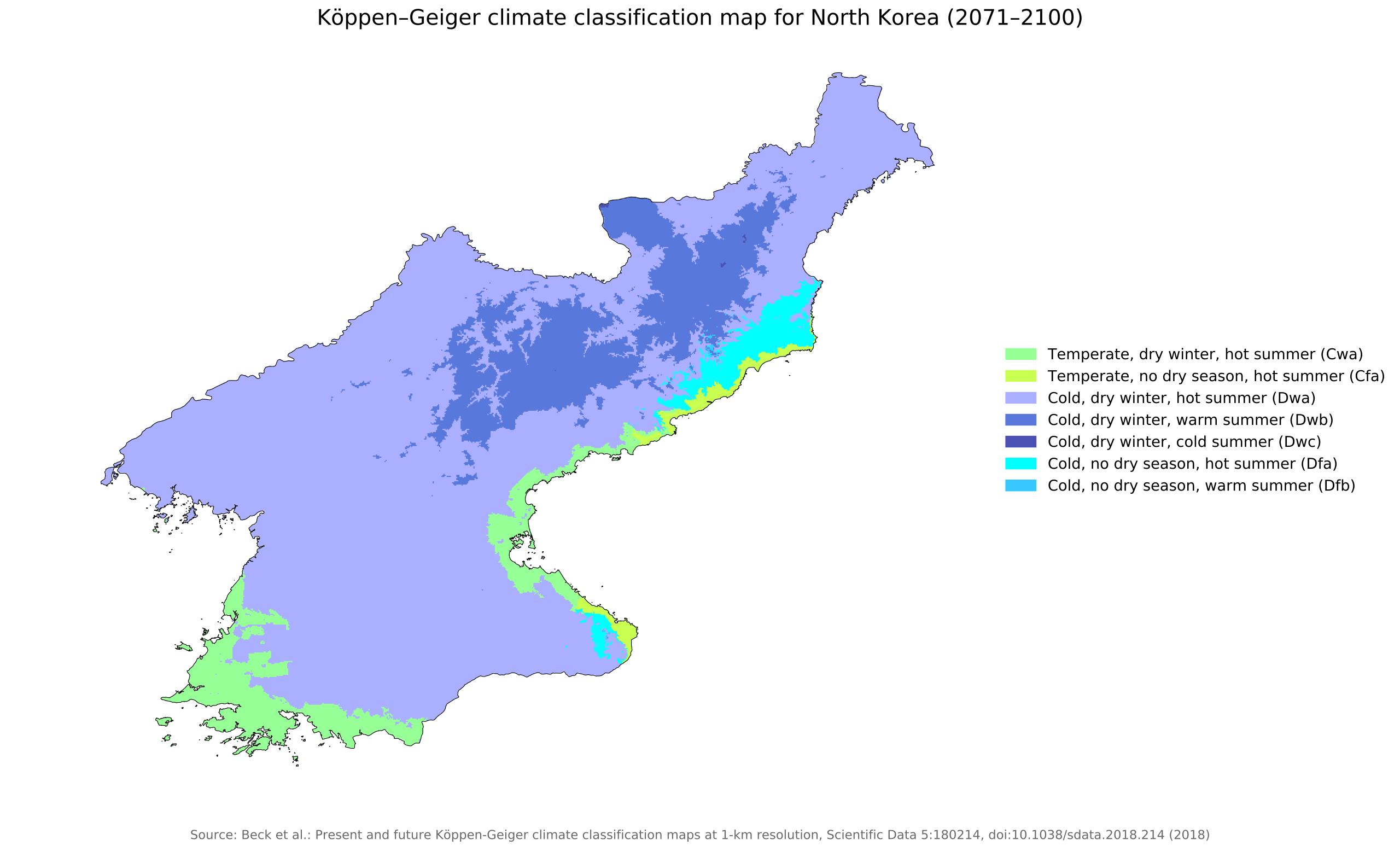
Beck, H.E., Zimmermann, N. E., McVicar, T. R., Vergopolan, N., Berg, A., & Wood, E. F.
8:
307:
100:
339:
168:"Present and future Köppen-Geiger climate classification maps at 1-km resolution".
544:
506:
468:
428:
384:
179:
570:
Click on a date/time to view the file as it appeared at that time.
286:
40° 18′ 16.14″ N, 127° 25′ 42.15″ E
293:
82:(SVG file, nominally 1,408 × 850 pixels, file size: 1.26 MB)
157:
88:
148:
Köppen–Geiger climate classification map for North Korea
333:
Add a one-line explanation of what this file represents
628:
568:
112:
Commons is a freely licensed media file repository.
435:Creative Commons Attribution 4.0 International
409:Creative Commons Attribution 4.0 International
93:
205:
153:
135:
187:
163:
14:
260:https://creativecommons.org/licenses/by/4.0
236:– to copy, distribute and transmit the work
41:Size of this PNG preview of this SVG file:
300:View this and other nearby images on:
124:
276:
630:The following page uses this file:
561:
512:40°18'16.14031"N, 127°25'42.15090"E
211:
173:
13:
643:
338:
332:
227:
202:
142:
125:
75:
677:
650:
337:
266:Creative Commons Attribution 4.0
497:coordinates of the point of view
487:coordinates of the point of view
323:
306:
292:
247:Under the following conditions:
218:This file is licensed under the
210:
204:
138:Koppen-Geiger Map PRK future.svg
92:
21:
320:
143:
565:
319:
26:
1:
635:Climate change in North Korea
223:Attribution 4.0 International
31:
625:
345:Items portrayed in this file
198:
7:
640:
10:
682:
132:
127:
562:
16:
322:
99:This is a file from the
36:
619:
598:05:28, 26 November 2018
156:
103:. Information from its
312:40.304483; 127.428375
180:10.1038/sdata.2018.214
170:Nature Scientific Data
106:description page there
65:2,560 × 1,545 pixels
242:– to adapt the work
47:Other resolutions:
69:1,408 × 850 pixels
61:1,280 × 773 pixels
57:1,024 × 618 pixels
669:
668:
623:
419:copyright license
405:copyright license
331:
317:
316:
195:
194:
121:
120:
101:Wikimedia Commons
673:
651:
610:
572:
375:copyright status
361:copyright status
329:
313:
310:
296:
295:
289:
288:
277:
273:
270:
267:
264:
261:
220:Creative Commons
214:
213:
208:
207:
183:
177:
159:
147:
139:
133:
117:
96:
95:
89:
83:
72:
53:640 × 386 pixels
49:320 × 193 pixels
43:800 × 483 pixels
681:
680:
676:
675:
674:
672:
671:
670:
639:
624:
616:
608:
564:
563:
560:
559:
558:
557:
556:
555:
554:
553:
551:
541:
540:
539:
537:
522:
521:
520:
519:
518:
517:
516:
515:
513:
503:
502:
501:
499:
484:
483:
482:
481:
480:
479:
478:
477:
475:
474:6 November 2018
465:
464:
463:
461:
446:
445:
444:
443:
442:
441:
440:
439:
437:
425:
424:
423:
421:
402:
401:
400:
399:
398:
397:
396:
395:
393:
381:
380:
379:
377:
358:
357:
356:
355:
354:
352:
336:
335:
334:
311:
284:
283:
280:Camera location
275:
274:
271:
268:
265:
262:
259:
258:
226:
215:
201:
196:
167:
158:6 November 2018
149:
137:
130:
123:
122:
111:
110:
109:is shown below.
85:
81:
74:
73:
46:
12:
11:
5:
679:
667:
666:
663:
659:
658:
655:
642:
638:
637:
627:
622:
621:
618:
614:
611:
605:
600:
595:
591:
590:
587:
584:
581:
578:
575:
567:
552:
549:
547:
546:
545:
543:
542:
538:
533:
531:
530:
529:
528:
526:
514:
511:
509:
508:
507:
505:
504:
500:
495:
493:
492:
491:
490:
488:
476:
473:
471:
470:
469:
467:
466:
462:
457:
455:
454:
453:
452:
450:
438:
433:
431:
430:
429:
427:
426:
422:
417:
415:
414:
413:
412:
410:
406:
394:
389:
387:
386:
385:
383:
382:
378:
373:
371:
370:
369:
368:
366:
362:
353:
348:
346:
343:
342:
341:
340:
328:
327:
324:
321:
315:
314:
304:
298:
281:
257:
256:
255:
254:
245:
244:
243:
237:
230:You are free:
217:
216:
203:
200:
197:
193:
192:
189:
185:
184:
165:
161:
160:
155:
151:
150:
140:
131:
129:
126:
119:
118:
97:
87:
86:
40:
35:
34:
29:
24:
19:
9:
6:
4:
3:
2:
678:
664:
661:
660:
656:
653:
652:
649:
646:
636:
633:
632:
631:
617:
612:
606:
604:
601:
599:
596:
593:
592:
588:
585:
582:
579:
576:
574:
573:
571:
550:image/svg+xml
548:
536:
532:
510:
498:
494:
472:
460:
456:
436:
432:
420:
416:
392:
388:
376:
372:
351:
347:
344:
325:
318:
309:
305:
303:
302:OpenStreetMap
299:
297:
287:
282:
279:
278:
252:
249:
248:
246:
241:
238:
235:
232:
231:
229:
228:
224:
221:
209:
190:
186:
181:
176:
171:
166:
162:
152:
146:
141:
134:
115:
108:
107:
102:
98:
91:
90:
84:
79:
78:Original file
70:
66:
62:
58:
54:
50:
44:
39:
33:
30:
28:
25:
23:
20:
18:
15:
647:
644:
629:
607:1,408 × 850
569:
566:File history
250:
239:
233:
169:
144:
114:You can help
104:
76:
22:File history
615:NVergopolan
391:copyrighted
365:copyrighted
251:attribution
136:Description
626:File usage
583:Dimensions
535:media type
525:media type
263:CC BY 4.0
27:File usage
609:(1.26 MB)
580:Thumbnail
577:Date/Time
459:inception
449:inception
199:Licensing
145:English:
641:Metadata
326:Captions
240:to remix
234:to share
225:license.
32:Metadata
594:current
589:Comment
350:depicts
330:English
128:Summary
80:
662:Height
657:1126pt
290:
188:Author
164:Source
665:680pt
654:Width
586:User
272:true
269:true
154:Date
17:File
175:DOI
172:.
67:|
63:|
59:|
55:|
51:|
45:.
182:.
178::
116:.
71:.
