Index
FileFile history
File usage
Global file usage
Metadata
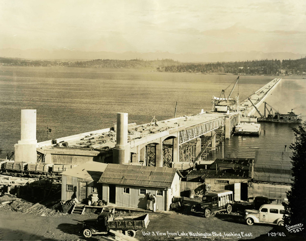
Lacey_V._Murrow_Bridge_construction.jpg
Wikimedia Commons
description page there
You can help
National Register of Historic Places
United States of America
87000866
http://blogs.sos.wa.gov/FromOurCorner/index.php/2011/01/building-the-first-lake-washington-floating-bridge/
47° 35′ 22.56″ N, 122° 17′ 21.12″ W
OpenStreetMap
geographical information
public domain
The State of Washington
The State of Washington
depicts<\/a>"}},"text\/plain":{"en":{"":"depicts"}}},"{\"value\":{\"entity-type\":\"item\",\"numeric-id\":2104072,\"id\":\"Q2104072\"},\"type\":\"wikibase-entityid\"}":{"text\/html":{"en":{"P180":"pontoon bridge<\/a>"}},"text\/plain":{"en":{"P180":"pontoon bridge"}}}}">
Items portrayed in this file
depicts
pontoon bridge
copyright status<\/a>"}},"text\/plain":{"en":{"":"copyright status"}}},"{\"value\":{\"entity-type\":\"item\",\"numeric-id\":88088423,\"id\":\"Q88088423\"},\"type\":\"wikibase-entityid\"}":{"text\/html":{"en":{"P6216":"copyrighted, dedicated to the public domain by copyright holder<\/a>"}},"text\/plain":{"en":{"P6216":"copyrighted, dedicated to the public domain by copyright holder"}}}}">copyright status
copyrighted, dedicated to the public domain by copyright holder
copyright license<\/a>"}},"text\/plain":{"en":{"":"copyright license"}}},"{\"value\":{\"entity-type\":\"item\",\"numeric-id\":98592850,\"id\":\"Q98592850\"},\"type\":\"wikibase-entityid\"}":{"text\/html":{"en":{"P275":"released into the public domain by the copyright holder<\/a>"}},"text\/plain":{"en":{"P275":"released into the public domain by the copyright holder"}}}}">copyright license
released into the public domain by the copyright holder
inception<\/a>"}},"text\/plain":{"en":{"":"inception"}}},"{\"value\":{\"time\":\"+1940-01-29T00:00:00Z\",\"timezone\":0,\"before\":0,\"after\":0,\"precision\":11,\"calendarmodel\":\"http:\\\/\\\/www.wikidata.org\\\/entity\\\/Q1985727\"},\"type\":\"time\"}":{"text\/html":{"en":{"P571":"29 January 1940"}},"text\/plain":{"en":{"P571":"29 January 1940"}}}}">inception
coordinates of the point of view<\/a>"}},"text\/plain":{"en":{"":"coordinates of the point of view"}}},"{\"value\":{\"latitude\":47.5896,\"longitude\":-122.2892,\"altitude\":null,\"precision\":0.0001,\"globe\":\"http:\\\/\\\/www.wikidata.org\\\/entity\\\/Q2\"},\"type\":\"globecoordinate\"}":{"text\/html":{"en":{"P1259":"47\u00b035'22.6"N, 122\u00b017'21.1"W"}},"text\/plain":{"en":{"P1259":"47\u00b035'22.6\"N, 122\u00b017'21.1\"W"}}}}">
Text is available under the Creative Commons Attribution-ShareAlike License. Additional terms may apply.
↑
copyright status
copyrighted, dedicated to the public domain by copyright holder
copyright license<\/a>"}},"text\/plain":{"en":{"":"copyright license"}}},"{\"value\":{\"entity-type\":\"item\",\"numeric-id\":98592850,\"id\":\"Q98592850\"},\"type\":\"wikibase-entityid\"}":{"text\/html":{"en":{"P275":"released into the public domain by the copyright holder<\/a>"}},"text\/plain":{"en":{"P275":"released into the public domain by the copyright holder"}}}}">copyright license
released into the public domain by the copyright holder
inception<\/a>"}},"text\/plain":{"en":{"":"inception"}}},"{\"value\":{\"time\":\"+1940-01-29T00:00:00Z\",\"timezone\":0,\"before\":0,\"after\":0,\"precision\":11,\"calendarmodel\":\"http:\\\/\\\/www.wikidata.org\\\/entity\\\/Q1985727\"},\"type\":\"time\"}":{"text\/html":{"en":{"P571":"29 January 1940"}},"text\/plain":{"en":{"P571":"29 January 1940"}}}}">inception
coordinates of the point of view<\/a>"}},"text\/plain":{"en":{"":"coordinates of the point of view"}}},"{\"value\":{\"latitude\":47.5896,\"longitude\":-122.2892,\"altitude\":null,\"precision\":0.0001,\"globe\":\"http:\\\/\\\/www.wikidata.org\\\/entity\\\/Q2\"},\"type\":\"globecoordinate\"}":{"text\/html":{"en":{"P1259":"47\u00b035'22.6"N, 122\u00b017'21.1"W"}},"text\/plain":{"en":{"P1259":"47\u00b035'22.6\"N, 122\u00b017'21.1\"W"}}}}">
Text is available under the Creative Commons Attribution-ShareAlike License. Additional terms may apply.
↑
copyright license
released into the public domain by the copyright holder
inception<\/a>"}},"text\/plain":{"en":{"":"inception"}}},"{\"value\":{\"time\":\"+1940-01-29T00:00:00Z\",\"timezone\":0,\"before\":0,\"after\":0,\"precision\":11,\"calendarmodel\":\"http:\\\/\\\/www.wikidata.org\\\/entity\\\/Q1985727\"},\"type\":\"time\"}":{"text\/html":{"en":{"P571":"29 January 1940"}},"text\/plain":{"en":{"P571":"29 January 1940"}}}}">inception
coordinates of the point of view<\/a>"}},"text\/plain":{"en":{"":"coordinates of the point of view"}}},"{\"value\":{\"latitude\":47.5896,\"longitude\":-122.2892,\"altitude\":null,\"precision\":0.0001,\"globe\":\"http:\\\/\\\/www.wikidata.org\\\/entity\\\/Q2\"},\"type\":\"globecoordinate\"}":{"text\/html":{"en":{"P1259":"47\u00b035'22.6"N, 122\u00b017'21.1"W"}},"text\/plain":{"en":{"P1259":"47\u00b035'22.6\"N, 122\u00b017'21.1\"W"}}}}">
Text is available under the Creative Commons Attribution-ShareAlike License. Additional terms may apply.
↑
inception
coordinates of the point of view<\/a>"}},"text\/plain":{"en":{"":"coordinates of the point of view"}}},"{\"value\":{\"latitude\":47.5896,\"longitude\":-122.2892,\"altitude\":null,\"precision\":0.0001,\"globe\":\"http:\\\/\\\/www.wikidata.org\\\/entity\\\/Q2\"},\"type\":\"globecoordinate\"}":{"text\/html":{"en":{"P1259":"47\u00b035'22.6"N, 122\u00b017'21.1"W"}},"text\/plain":{"en":{"P1259":"47\u00b035'22.6\"N, 122\u00b017'21.1\"W"}}}}">
Text is available under the Creative Commons Attribution-ShareAlike License. Additional terms may apply.
↑
Text is available under the Creative Commons Attribution-ShareAlike License. Additional terms may apply.
↑