43:
443:"}},"text\/plain":{"en":{"":"coordinates of the point of view"}}},"{\"value\":{\"latitude\":-27.5035,\"longitude\":153.3597,\"altitude\":null,\"precision\":0.0001,\"globe\":\"http:\\\/\\\/www.wikidata.org\\\/entity\\\/Q2\"},\"type\":\"globecoordinate\"}":{"text\/html":{"en":{"P1259":"27\u00b030'12.6"S, 153\u00b021'34.9"E"}},"text\/plain":{"en":{"P1259":"27\u00b030'12.6\"S, 153\u00b021'34.9\"E"}}}}": -->
481:"}},"text\/plain":{"en":{"":"inception"}}},"{\"value\":{\"time\":\"+2017-01-01T00:00:00Z\",\"timezone\":0,\"before\":0,\"after\":0,\"precision\":9,\"calendarmodel\":\"http:\\\/\\\/www.wikidata.org\\\/entity\\\/Q1985727\"},\"type\":\"time\"}":{"text\/html":{"en":{"P571":"2017"}},"text\/plain":{"en":{"P571":"2017"}}}}": -->
240:
207:
221:
246:
99:
399:"}},"text\/plain":{"en":{"":"copyright license"}}},"{\"value\":{\"entity-type\":\"item\",\"numeric-id\":20007257,\"id\":\"Q20007257\"},\"type\":\"wikibase-entityid\"}":{"text\/html":{"en":{"P275":"
355:"}},"text\/plain":{"en":{"":"copyright status"}}},"{\"value\":{\"entity-type\":\"item\",\"numeric-id\":50423863,\"id\":\"Q50423863\"},\"type\":\"wikibase-entityid\"}":{"text\/html":{"en":{"P6216":"
557:
439:
204:
69:
65:
61:
57:
53:
47:
110:
78:
400:
356:
440:
352:
478:
396:
403:"}},"text\/plain":{"en":{"P275":"Creative Commons Attribution 4.0 International"}}}}": -->
426:
382:
214:
653:
619:
This file contains additional information, probably added from the digital camera or scanner used to create or digitize it.
450:
366:
556:
551:
173:
42:
488:
410:
341:
588:
622:
If the file has been modified from its original state, some details may not fully reflect the modified file.
256:
359:"}},"text\/plain":{"en":{"P6216":"copyrighted"}}}}": -->
118:
253:
8:
567:
220:
105:
331:
174:
https://ecq.qld.gov.au/__data/assets/pdf_file/0003/69366/ECQ-2017-Final-Oodgeroo.pdf
606:
498:
460:
420:
376:
524:
Click on a date/time to view the file as it appeared at that time.
206:
199:
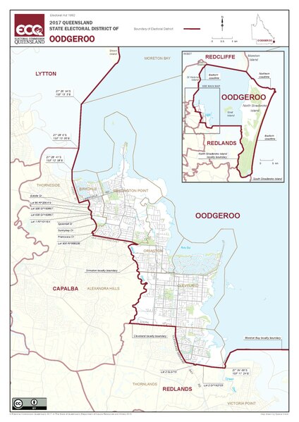
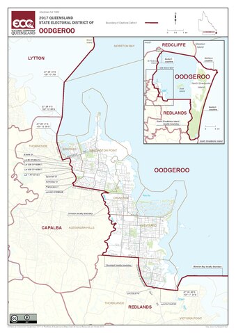
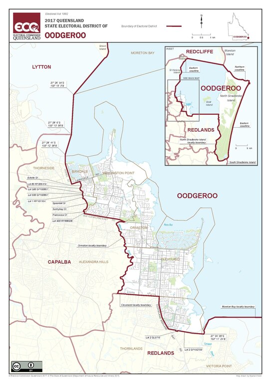
27° 30′ 12.6″ S, 153° 21′ 34.92″ E
172:
2017 Queensland State
Electoral district of Oodgeroo, from
93:
325:
Add a one-line explanation of what this file represents
83:(1,752 × 2,479 pixels, file size: 2.02 MB, MIME type:
582:
597:
522:
117:
Commons is a freely licensed media file repository.
162:
143:
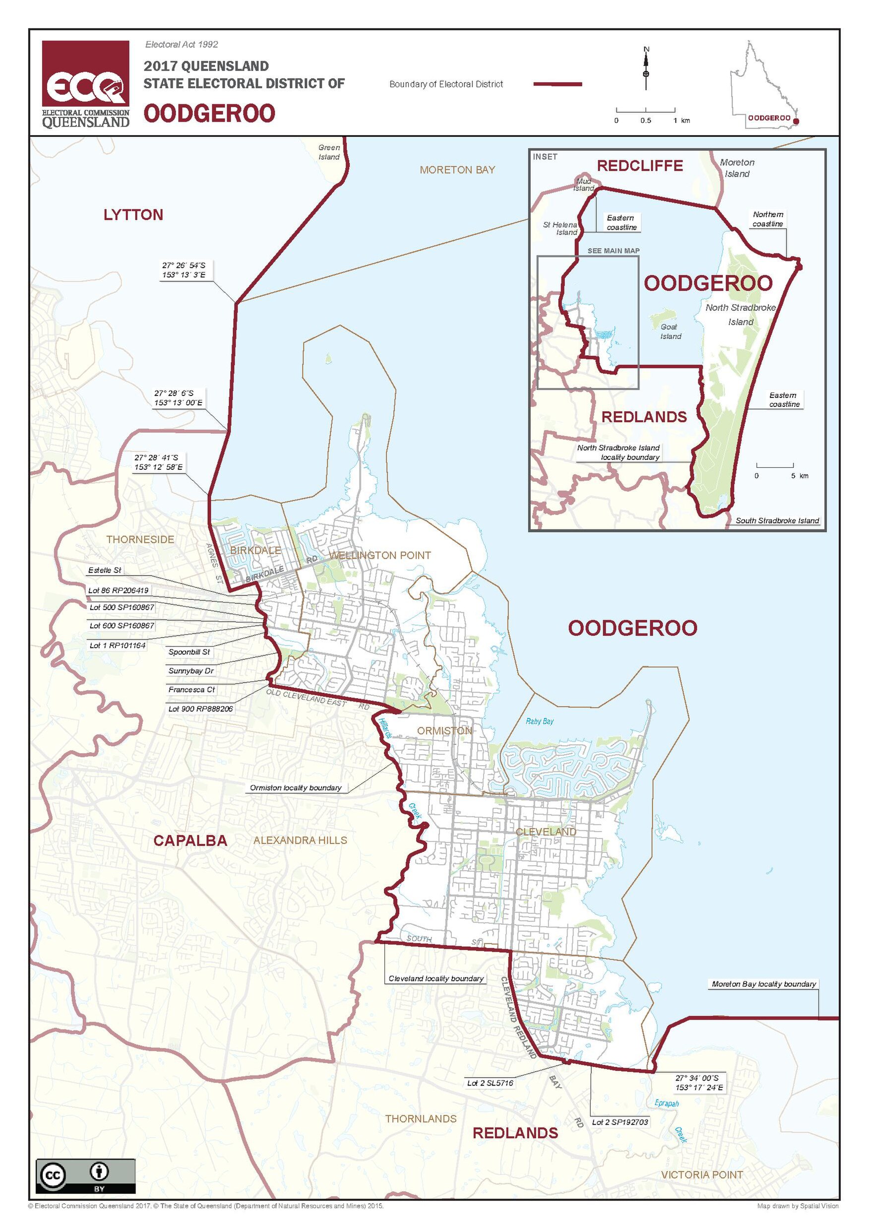
Map of the electoral district of
Oodgeroo, 2017.pdf
153:Map of the electoral district of Oodgeroo, 2017
427:Creative Commons Attribution 4.0 International
401:Creative Commons Attribution 4.0 International
98:
239:
158:
140:
179:
168:
14:
294:https://creativecommons.org/licenses/by/4.0
270:– to copy, distribute and transmit the work
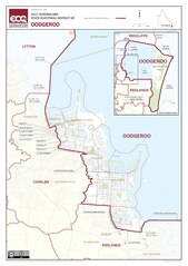
46:Size of this JPG preview of this PDF file:
687:uuid:0e2d0abf-707f-4807-b1a9-b8fef6326d6f
599:The following other wikis use this file:
213:View this and other nearby images on:
654:Adobe Illustrator CC 2015.3 (Windows)
129:
189:
584:The following page uses this file:
574:User created page with UploadWizard
515:
245:
13:
617:
330:
324:
261:
236:
183:Electoral Commission of Queensland
147:
130:
76:
731:
624:
329:
300:Creative Commons Attribution 4.0
451:coordinates of the point of view
441:coordinates of the point of view
315:
281:Under the following conditions:
252:This file is licensed under the
244:
238:
219:
205:
97:
31:
21:
676:Date metadata was last modified
312:
148:
684:Unique ID of original document
607:Electoral district of Oodgeroo
603:Usage on simple.wikipedia.org
594:
589:Electoral district of Oodgeroo
519:
311:
26:
1:
257:Attribution 4.0 International
36:
579:
337:Items portrayed in this file
232:
7:
668:Date and time of digitizing
614:
466:27°30'12.6"S, 153°21'34.9"E
10:
736:
137:
132:
660:File change date and time
516:
16:
314:
104:This is a file from the
41:
695:Adobe PDF library 15.00
573:
225:-27.503500; 153.359700
161:
108:. Information from its
552:21:28, 4 November 2017
111:description page there
716:Version of PDF format
711:841.89 x 1190.55 pts
70:1,752 × 2,479 pixels
634:2017-Final-Oodgeroo
276:– to adapt the work
52:Other resolutions:
692:Conversion program
679:19:48, 25 May 2017
671:04:02, 19 May 2017
663:19:48, 25 May 2017
66:724 × 1,024 pixels
723:
722:
595:Global file usage
577:
411:copyright license
397:copyright license
323:
230:
229:
187:
186:
126:
125:
106:Wikimedia Commons
32:Global file usage
727:
635:
625:
564:
526:
367:copyright status
353:copyright status
321:
307:
304:
301:
298:
295:
254:Creative Commons
248:
247:
242:
241:
226:
223:
209:
208:
202:
201:
190:
164:
152:
144:
138:
122:
101:
100:
94:
88:
86:
73:
62:543 × 768 pixels
58:339 × 480 pixels
54:169 × 240 pixels
48:424 × 600 pixels
735:
734:
730:
729:
728:
726:
725:
724:
633:
613:
593:
578:
570:
562:
518:
517:
514:
513:
512:
511:
510:
509:
508:
507:
505:
495:
494:
493:
491:
476:
475:
474:
473:
472:
471:
470:
469:
467:
457:
456:
455:
453:
438:
437:
436:
435:
434:
433:
432:
431:
429:
417:
416:
415:
413:
394:
393:
392:
391:
390:
389:
388:
387:
385:
373:
372:
371:
369:
350:
349:
348:
347:
346:
344:
328:
327:
326:
309:
308:
305:
302:
299:
296:
293:
292:
260:
249:
235:
224:
197:
196:
193:Camera location
188:
154:
142:
135:
128:
127:
116:
115:
114:is shown below.
90:
85:application/pdf
84:
82:
75:
74:
51:
12:
11:
5:
733:
721:
720:
717:
713:
712:
709:
705:
704:
701:
697:
696:
693:
689:
688:
685:
681:
680:
677:
673:
672:
669:
665:
664:
661:
657:
656:
651:
647:
646:
643:
639:
638:
637:
636:
629:
616:
612:
611:
610:
609:
596:
592:
591:
581:
576:
575:
572:
568:
565:
561:1,752 × 2,479
559:
554:
549:
545:
544:
541:
538:
535:
532:
529:
521:
506:
503:
501:
500:
499:
497:
496:
492:
487:
485:
484:
483:
482:
480:
468:
465:
463:
462:
461:
459:
458:
454:
449:
447:
446:
445:
444:
442:
430:
425:
423:
422:
421:
419:
418:
414:
409:
407:
406:
405:
404:
402:
398:
386:
381:
379:
378:
377:
375:
374:
370:
365:
363:
362:
361:
360:
358:
354:
345:
340:
338:
335:
334:
333:
332:
320:
319:
316:
313:
291:
290:
289:
288:
279:
278:
277:
271:
264:You are free:
251:
250:
237:
234:
231:
228:
227:
217:
211:
194:
185:
184:
181:
177:
176:
170:
166:
165:
160:
156:
155:
145:
136:
134:
131:
124:
123:
102:
92:
91:
45:
40:
39:
34:
29:
24:
19:
9:
6:
4:
3:
2:
732:
718:
715:
714:
710:
707:
706:
702:
699:
698:
694:
691:
690:
686:
683:
682:
678:
675:
674:
670:
667:
666:
662:
659:
658:
655:
652:
650:Software used
649:
648:
644:
641:
640:
632:
631:
630:
627:
626:
623:
620:
608:
605:
604:
602:
601:
600:
590:
587:
586:
585:
571:
569:Kerry Raymond
566:
560:
558:
555:
553:
550:
547:
546:
542:
539:
536:
533:
530:
528:
527:
525:
502:
490:
486:
464:
452:
448:
428:
424:
412:
408:
384:
380:
368:
364:
343:
339:
336:
317:
310:
286:
283:
282:
280:
275:
272:
269:
266:
265:
263:
262:
258:
255:
243:
222:
218:
216:
215:OpenStreetMap
212:
210:
200:
195:
192:
191:
182:
178:
175:
171:
167:
157:
151:
146:
139:
120:
113:
112:
107:
103:
96:
95:
89:
80:
79:Original file
71:
67:
63:
59:
55:
49:
44:
38:
35:
33:
30:
28:
25:
23:
20:
18:
15:
621:
618:
598:
583:
523:
520:File history
284:
273:
267:
149:
119:You can help
109:
77:
22:File history
628:Short title
383:copyrighted
357:copyrighted
285:attribution
141:Description
580:File usage
537:Dimensions
297:CC BY 4.0
27:File usage
708:Page size
700:Encrypted
563:(2.02 MB)
534:Thumbnail
531:Date/Time
489:inception
479:inception
233:Licensing
150:English:
615:Metadata
318:Captions
274:to remix
268:to share
259:license.
37:Metadata
548:current
543:Comment
342:depicts
322:English
133:Summary
81:
642:Author
203:
180:Author
169:Source
540:User
504:2017
306:true
303:true
163:2017
159:Date
17:File
719:1.5
645:ECQ
703:no
68:|
64:|
60:|
56:|
50:.
121:.
87:)
72:.