346:
358:
137:
602:"}},"text\/plain":{"en":{"":"inception"}}},"{\"value\":{\"time\":\"+2016-05-18T00:00:00Z\",\"timezone\":0,\"before\":0,\"after\":0,\"precision\":11,\"calendarmodel\":\"http:\\\/\\\/www.wikidata.org\\\/entity\\\/Q1985727\"},\"type\":\"time\"}":{"text\/html":{"en":{"P571":"18 May 2016"}},"text\/plain":{"en":{"P571":"18 May 2016"}}}}": -->
334:
43:
312:
298:
384:
169:
390:
395:
184:
99:
558:"}},"text\/plain":{"en":{"":"copyright license"}}},"{\"value\":{\"entity-type\":\"item\",\"numeric-id\":18199165,\"id\":\"Q18199165\"},\"type\":\"wikibase-entityid\"}":{"text\/html":{"en":{"P275":"
514:"}},"text\/plain":{"en":{"":"copyright status"}}},"{\"value\":{\"entity-type\":\"item\",\"numeric-id\":50423863,\"id\":\"Q50423863\"},\"type\":\"wikibase-entityid\"}":{"text\/html":{"en":{"P6216":"
510:
232:
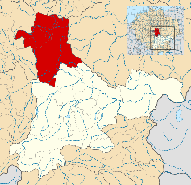
Note that while it uses the same scheme as standard location/locator maps, this map technically does not conform to the standard, as it is not in equirectangular projection. Therefore grid lines for latitude and longitude are also included on the
786:
The map is derived from a vectorised version of one found in
Professor G. Droysens Allgemeiner Historischer Handatlas, which was published in 1886 by R. Andrée Plate, and is now in the public domain. The source scan can be found at
436:– You must give appropriate credit, provide a link to the license, and indicate if changes were made. You may do so in any reasonable manner, but not in any way that suggests the licensor endorses you or your use.
230:
The map is derived from a vectorised version of one found in
Professor G. Droysens Allgemeiner Historischer Handatlas, which was published in 1886 by R. Andrée Plate, and is now in the public domain.
559:
515:
511:
599:
555:
152:
This map implies sovereignty over areas later known as Upper
Palatinate, which in fact were frankish respective imperial territory at this point in time.
73:
69:
65:
61:
57:
53:
47:
345:
562:"}},"text\/plain":{"en":{"P275":"Creative Commons Attribution-ShareAlike 4.0 International"}}}}": -->
82:
110:
357:
333:
699:(German: ''Markgrafschaft Nordgau'') within the Duchy of Bavaria around the year 1000. The map is deriv...
585:
541:
764:
This file contains additional information, probably added from the digital camera or scanner used to create or digitize it.
443:
317:
525:
784:
A map of the
Margraviate of Nordgau (German: Markgrafschaft Nordgau) within the Duchy of Bavaria around the year 1000.
609:
569:
500:
405:
767:
If the file has been modified from its original state, some details may not fully reflect the modified file.
442:– If you remix, transform, or build upon the material, you must distribute your contributions under the
713:
518:"}},"text\/plain":{"en":{"P6216":"copyrighted"}}}}": -->
677:
672:
42:
260:
118:
311:
297:
221:
696:
402:
8:
157:
105:
490:
794:
695:== {{int:filedesc}} == {{Inkscape}} {{Information |Description={{en|A map of the
272:
688:
193:
153:
619:
579:
535:
793:
Released under
CreativeCommons Attribution-ShareAlike 4.0 (CC BY-SA 4.0;
788:
731:
197:
645:
Click on a date/time to view the file as it appeared at that time.
741:
144:
798:
183:
87:(SVG file, nominally 1,875 × 1,815 pixels, file size: 5.74 MB)
751:
351:
Locator map of the whole of Saxony within the German
Kingdom
586:
Creative
Commons Attribution-ShareAlike 4.0 International
560:
Creative
Commons Attribution-ShareAlike 4.0 International
242:
93:
484:
Add a one-line explanation of what this file represents
789:
https://commons.wikimedia.org/File:Droysens-22-23.jpg
707:
722:
643:
228:) within the Duchy of Bavaria around the year 1000.
117:
Commons is a freely licensed media file repository.
363:Locator map of Bavaria within the German Kingdom
795:https://creativecommons.org/licenses/by-sa/4.0/
453:https://creativecommons.org/licenses/by-sa/4.0
339:The whole of Germany, showing the stem duchies
98:
459:Creative Commons Attribution-Share Alike 4.0
383:
238:
207:
799:https://commons.wikimedia.org/User:Alphathon
286:
266:
248:
14:
419:– to copy, distribute and transmit the work
46:Size of this PNG preview of this SVG file:
724:The following other wikis use this file:
406:Attribution-Share Alike 4.0 International
797:) by Wikimedia Commons user Alphathon (
129:
131:
709:The following page uses this file:
636:
394:
389:
13:
762:
697:March/Margraviate of (the) Nordgau
489:
483:
380:
222:March/Margraviate of (the) Nordgau
214:
188:
130:
80:
829:
769:
488:
270:
474:
430:Under the following conditions:
401:This file is licensed under the
393:
388:
382:
356:
344:
332:
310:
296:
182:
167:
135:
97:
31:
21:
471:
215:
719:
640:
470:
210:Nordgau locator map (1000).svg
26:
1:
147:or the file name is disputed.
143:The factual accuracy of this
36:
704:
496:Items portrayed in this file
376:
273:
162:) 19:27, 23 April 2023 (UTC)
7:
759:
10:
834:
748:Usage on it.wikipedia.org
738:Usage on fr.wikipedia.org
728:Usage on cs.wikipedia.org
714:Margraviate of the Nordgau
444:same or compatible license
204:
177:
637:
136:
16:
776:Nordgau um das Jahr 1000
473:
410:
104:This is a file from the
41:
694:
261:File:Droysens-22-23.jpg
241:
134:
108:. Information from its
226:Markgrafschaft Nordgau
151:
111:description page there
742:Margraviat de Nordgau
74:1,875 × 1,815 pixels
70:2,116 × 2,048 pixels
66:1,058 × 1,024 pixels
732:Markrabství Nordgau
425:– to adapt the work
52:Other resolutions:
673:16:17, 18 May 2016
821:
820:
720:Global file usage
702:
570:copyright license
556:copyright license
482:
373:
372:
281:
280:/ˈæɫfə.θɒn/
196:was created with
175:
174:
126:
125:
106:Wikimedia Commons
32:Global file usage
825:
770:
752:Marca di Nordgau
685:
647:
526:copyright status
512:copyright status
480:
466:
463:
460:
457:
454:
446:as the original.
403:Creative Commons
397:
396:
392:
391:
386:
385:
360:
348:
336:
314:
300:
282:
279:
275:
244:
219:
211:
205:
186:
171:
170:
160:
139:
138:
132:
122:
101:
100:
94:
88:
77:
62:793 × 768 pixels
58:496 × 480 pixels
54:248 × 240 pixels
48:619 × 599 pixels
833:
832:
828:
827:
826:
824:
823:
822:
758:
718:
703:
691:
683:
639:
638:
635:
634:
633:
632:
631:
630:
629:
628:
626:
616:
615:
614:
612:
597:
596:
595:
594:
593:
592:
591:
590:
588:
576:
575:
574:
572:
553:
552:
551:
550:
549:
548:
547:
546:
544:
532:
531:
530:
528:
509:
508:
507:
506:
505:
503:
487:
486:
485:
468:
467:
464:
461:
458:
455:
452:
451:
409:
398:
379:
374:
369:
368:
367:
364:
361:
352:
349:
340:
337:
325:
324:
323:
320:
315:
306:
301:
234:
209:
202:
201:
191:W3C-unspecified
180:
168:
164:
163:
158:
148:
128:
127:
116:
115:
114:is shown below.
90:
86:
79:
78:
51:
12:
11:
5:
831:
819:
818:
815:
811:
810:
807:
803:
802:
782:
778:
777:
774:
761:
757:
756:
755:
754:
746:
745:
744:
736:
735:
734:
721:
717:
716:
706:
701:
700:
693:
689:
686:
682:1,875 × 1,815
680:
675:
670:
666:
665:
662:
659:
656:
653:
650:
642:
627:
624:
622:
621:
620:
618:
617:
613:
608:
606:
605:
604:
603:
601:
589:
584:
582:
581:
580:
578:
577:
573:
568:
566:
565:
564:
563:
561:
557:
545:
540:
538:
537:
536:
534:
533:
529:
524:
522:
521:
520:
519:
517:
513:
504:
499:
497:
494:
493:
492:
491:
479:
478:
475:
472:
450:
449:
448:
447:
437:
428:
427:
426:
420:
413:You are free:
400:
399:
381:
378:
375:
371:
370:
366:
365:
362:
355:
353:
350:
343:
341:
338:
331:
328:
327:
326:
322:
321:
316:
309:
307:
302:
295:
292:
291:
290:
288:
287:Other versions
284:
283:
268:
264:
263:
250:
246:
245:
240:
236:
235:
212:
203:
181:
179:
176:
173:
172:
165:
149:
142:
140:
124:
123:
102:
92:
91:
45:
40:
39:
34:
29:
24:
19:
9:
6:
4:
3:
2:
830:
816:
813:
812:
808:
805:
804:
800:
796:
792:
790:
783:
780:
779:
775:
772:
771:
768:
765:
753:
750:
749:
747:
743:
740:
739:
737:
733:
730:
729:
727:
726:
725:
715:
712:
711:
710:
698:
692:
687:
681:
679:
676:
674:
671:
668:
667:
663:
660:
657:
654:
651:
649:
648:
646:
623:
611:
607:
587:
583:
571:
567:
543:
539:
527:
523:
502:
498:
495:
476:
469:
456:CC BY-SA 4.0
445:
441:
438:
435:
432:
431:
429:
424:
421:
418:
415:
414:
412:
411:
407:
404:
387:
359:
354:
347:
342:
335:
330:
329:
319:
313:
308:
305:
299:
294:
293:
289:
285:
277:
276:
269:
265:
262:
259:
256:
254:
251:
247:
237:
231:
227:
223:
220:A map of the
218:
213:
206:
199:
195:
192:
185:
166:
161:
155:
146:
141:
133:
120:
113:
112:
107:
103:
96:
95:
89:
84:
83:Original file
75:
71:
67:
63:
59:
55:
49:
44:
38:
35:
33:
30:
28:
25:
23:
20:
18:
15:
785:
766:
763:
723:
708:
644:
641:File history
439:
433:
422:
416:
303:
271:
257:
252:
229:
225:
216:
194:vector image
190:
119:You can help
109:
81:
22:File history
781:Image title
773:Short title
625:18 May 2016
542:copyrighted
516:copyrighted
440:share alike
434:attribution
243:18 May 2016
208:Description
705:File usage
658:Dimensions
27:File usage
690:Alphathon
684:(5.74 MB)
655:Thumbnail
652:Date/Time
610:inception
600:inception
377:Licensing
274:Alphathon
224:(German:
217:English:
760:Metadata
477:Captions
423:to remix
417:to share
408:license.
255:own work
233:sub-map.
198:Inkscape
150:Reason:
37:Metadata
669:current
664:Comment
501:depicts
481:English
318:Austria
304:Nordgau
178:Summary
154:Willi P
85:
814:Height
278:
267:Author
249:Source
187:
806:Width
258:Data:
253:File:
189:This
817:1815
809:1875
661:User
465:true
462:true
239:Date
159:talk
17:File
145:map
791:.
72:|
68:|
64:|
60:|
56:|
50:.
801:)
200:.
156:(
121:.
76:.
Text is available under the Creative Commons Attribution-ShareAlike License. Additional terms may apply.

.svg)
.svg)
.svg)