752:"}},"text\/plain":{"en":{"":"coordinates of depicted place"}}},"{\"value\":{\"latitude\":55.9128,\"longitude\":-2.94,\"altitude\":null,\"precision\":0.0001,\"globe\":\"http:\\\/\\\/www.wikidata.org\\\/entity\\\/Q2\"},\"type\":\"globecoordinate\"}":{"text\/html":{"en":{"P9149":"55\u00b054'46.1"N, 2\u00b056'24.0"W"}},"text\/plain":{"en":{"P9149":"55\u00b054'46.1\"N, 2\u00b056'24.0\"W"}}}}": -->
412:"}},"text\/plain":{"en":{"":"author name string"}}},"{\"value\":\"Richard Webb\",\"type\":\"string\"}":{"text\/html":{"en":{"P2093":"Richard Webb"}},"text\/plain":{"en":{"P2093":"Richard Webb"}}},"{\"value\":{\"entity-type\":\"property\",\"numeric-id\":2699,\"id\":\"P2699\"},\"type\":\"wikibase-entityid\"}":{"text\/html":{"en":{"":"
714:"}},"text\/plain":{"en":{"":"inception"}}},"{\"value\":{\"time\":\"+2005-06-18T00:00:00Z\",\"timezone\":0,\"before\":0,\"after\":0,\"precision\":11,\"calendarmodel\":\"http:\\\/\\\/www.wikidata.org\\\/entity\\\/Q1985727\"},\"type\":\"time\"}":{"text\/html":{"en":{"P571":"18 June 2005"}},"text\/plain":{"en":{"P571":"18 June 2005"}}}}": -->
591:
396:
208:
232:
270:
275:
67:
599:"}},"text\/plain":{"en":{"P7482":"file available on the internet"}}},"{\"value\":{\"entity-type\":\"property\",\"numeric-id\":7384,\"id\":\"P7384\"},\"type\":\"wikibase-entityid\"}":{"text\/html":{"en":{"":"
404:"}},"text\/plain":{"en":{"":"object of statement has role"}}},"{\"value\":{\"entity-type\":\"item\",\"numeric-id\":33231,\"id\":\"Q33231\"},\"type\":\"wikibase-entityid\"}":{"text\/html":{"en":{"P3831":"
615:"}},"text\/plain":{"en":{"P137":"Geograph Britain and Ireland"}}},"{\"value\":{\"entity-type\":\"property\",\"numeric-id\":973,\"id\":\"P973\"},\"type\":\"wikibase-entityid\"}":{"text\/html":{"en":{"":"
551:"}},"text\/plain":{"en":{"":"copyright license"}}},"{\"value\":{\"entity-type\":\"item\",\"numeric-id\":19068220,\"id\":\"Q19068220\"},\"type\":\"wikibase-entityid\"}":{"text\/html":{"en":{"P275":"
507:"}},"text\/plain":{"en":{"":"copyright status"}}},"{\"value\":{\"entity-type\":\"item\",\"numeric-id\":50423863,\"id\":\"Q50423863\"},\"type\":\"wikibase-entityid\"}":{"text\/html":{"en":{"P6216":"
595:"}},"text\/plain":{"en":{"":"source of file"}}},"{\"value\":{\"entity-type\":\"item\",\"numeric-id\":74228490,\"id\":\"Q74228490\"},\"type\":\"wikibase-entityid\"}":{"text\/html":{"en":{"P7482":"
408:"}},"text\/plain":{"en":{"P3831":"photographer"}}},"{\"value\":{\"entity-type\":\"property\",\"numeric-id\":2093,\"id\":\"P2093\"},\"type\":\"wikibase-entityid\"}":{"text\/html":{"en":{"":"
611:"}},"text\/plain":{"en":{"":"operator"}}},"{\"value\":{\"entity-type\":\"item\",\"numeric-id\":1503119,\"id\":\"Q1503119\"},\"type\":\"wikibase-entityid\"}":{"text\/html":{"en":{"P137":"
607:"}},"text\/plain":{"en":{"P7384":"19701"}}},"{\"value\":{\"entity-type\":\"property\",\"numeric-id\":137,\"id\":\"P137\"},\"type\":\"wikibase-entityid\"}":{"text\/html":{"en":{"":"
400:"}},"text\/plain":{"en":{"":"creator"}}},"{\"value\":{\"entity-type\":\"property\",\"numeric-id\":3831,\"id\":\"P3831\"},\"type\":\"wikibase-entityid\"}":{"text\/html":{"en":{"":"
748:
603:"}},"text\/plain":{"en":{"":"geograph.org.uk image ID"}}},"{\"value\":\"19701\",\"type\":\"string\"}":{"text\/html":{"en":{"P7384":"
845:
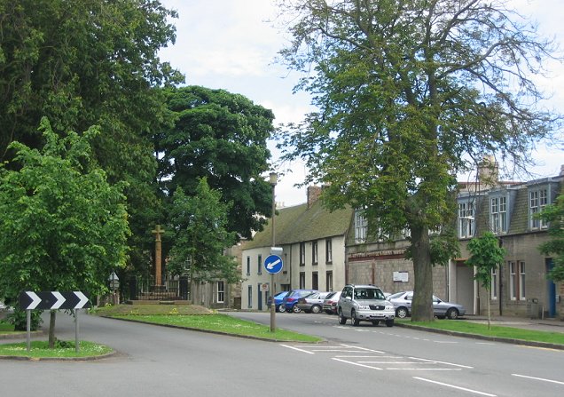
The Mercat Cross, in the middle of the broad main street of this village. Ormiston was to have been a sizable town, but it never took off. However the coming of coal mining led to an expansion of the village. {{geograph|19701|Richard
185:
322:– You must give appropriate credit, provide a link to the license, and indicate if changes were made. You may do so in any reasonable manner, but not in any way that suggests the licensor endorses you or your use.
121:
Ormiston. The Mercat Cross, in the middle of the broad main street of this village. Ormiston was to have been a sizable town, but it never took off. However the coming of coal mining led to an expansion of the
38:
191:
596:
552:
508:
604:
612:
405:
749:
600:
592:
504:
413:
409:
401:
711:
616:
608:
548:
397:
620:
417:
555:"}},"text\/plain":{"en":{"P275":"Creative Commons Attribution-ShareAlike 2.0 Generic"}}}}": -->
163:
420:"}},"text\/plain":{"en":{"P2699":"https:\/\/www.geograph.org.uk\/profile\/196"}}}}": -->
623:"}},"text\/plain":{"en":{"P973":"https:\/\/www.geograph.org.uk\/photo\/19701"}}}}": -->
646:
578:
534:
201:
681:
239:
329:
461:
759:
659:
630:
518:
482:
469:
454:
721:
689:
674:
562:
427:
386:
285:
328:– If you remix, transform, or build upon the material, you must distribute your contributions under the
246:
on the
Geograph website for the photographer's contact details. The copyright on this image is owned by
511:"}},"text\/plain":{"en":{"P6216":"copyrighted"}}}}": -->
78:
928:
46:
86:
878:
282:
696:
666:
489:
8:
226:
207:
251:
73:
376:
827:
822:
37:
152:
142:
231:
769:
731:
640:
572:
528:
437:
838:
243:
938:
860:
795:
Click on a date/time to view the file as it appeared at that time.
193:
186:
55° 54′ 46″ N, 2° 56′ 24″ W
131:
61:
370:
Add a one-line explanation of what this file represents
888:
988:
978:
968:
958:
948:
918:
908:
898:
854:
869:
793:
170:
Creative
Commons Attribution Share-alike license 2.0
85:
Commons is a freely licensed media file repository.
579:
Creative
Commons Attribution-ShareAlike 2.0 Generic
553:
Creative
Commons Attribution-ShareAlike 2.0 Generic
51:(636 × 447 pixels, file size: 98 KB, MIME type:
339:https://creativecommons.org/licenses/by-sa/2.0
66:
345:Creative Commons Attribution-Share Alike 2.0
263:
158:
127:
108:
148:
137:
14:
621:https:\/\/www.geograph.org.uk\/photo\/19701
418:https:\/\/www.geograph.org.uk\/profile\/196
305:– to copy, distribute and transmit the work
871:The following other wikis use this file:
697:https://www.geograph.org.uk/photo/19701
490:https://www.geograph.org.uk/profile/196
200:View this and other nearby images on:
97:
250:and is licensed for reuse under the
176:
856:The following page uses this file:
786:
286:Attribution-Share Alike 2.0 Generic
274:
269:
254:Attribution-ShareAlike 2.0 license.
13:
375:
369:
260:
237:
115:
98:
44:
1002:
374:
360:
316:Under the following conditions:
281:This file is licensed under the
273:
268:
262:
230:
206:
192:
65:
31:
21:
357:
116:
41:No higher resolution available.
866:
790:
647:file available on the internet
597:file available on the internet
356:
238:This image was taken from the
26:
1:
760:coordinates of depicted place
750:coordinates of depicted place
851:
682:Geograph Britain and Ireland
613:Geograph Britain and Ireland
455:object of statement has role
402:object of statement has role
382:Items portrayed in this file
222:
7:
885:Usage on ceb.wikipedia.org
10:
1007:
985:Usage on www.wikidata.org
975:Usage on sv.wikipedia.org
965:Usage on nl.wikipedia.org
955:Usage on it.wikipedia.org
945:Usage on ga.wikipedia.org
935:Usage on fr.wikipedia.org
925:Usage on fa.wikipedia.org
915:Usage on eu.wikipedia.org
905:Usage on es.wikipedia.org
895:Usage on cy.wikipedia.org
875:Usage on bg.wikipedia.org
330:same or compatible license
105:
100:
787:
775:55°54'46.1"N, 2°56'24.0"W
16:
660:geograph.org.uk image ID
601:geograph.org.uk image ID
359:
296:
72:This is a file from the
36:
844:
130:
76:. Information from its
244:this photograph's page
212:55.912800; -2.940000
79:description page there
823:14:36, 5 April 2006
311:– to adapt the work
470:author name string
410:author name string
939:Ormiston (Écosse)
867:Global file usage
849:
563:copyright license
549:copyright license
368:
259:
258:
242:collection. See
217:
216:
174:
173:
167:
164:Reusing this file
94:
93:
74:Wikimedia Commons
32:Global file usage
998:
835:
797:
699:
694:
690:described at URL
684:
679:
669:
664:
617:described at URL
519:copyright status
505:copyright status
492:
487:
477:
474:
464:
459:
366:
352:
349:
346:
343:
340:
332:as the original.
294:
283:Creative Commons
277:
276:
272:
271:
266:
265:
252:Creative Commons
240:Geograph project
234:
227:
213:
210:
196:
195:
189:
188:
177:
161:
133:
120:
112:
106:
90:
69:
68:
62:
56:
54:
1006:
1005:
1001:
1000:
999:
997:
996:
995:
865:
850:
841:
833:
789:
788:
785:
784:
783:
782:
781:
780:
779:
778:
776:
766:
765:
764:
762:
747:
746:
745:
744:
743:
742:
741:
740:
738:
728:
727:
726:
724:
709:
708:
707:
706:
705:
704:
703:
702:
701:
700:
695:
692:
686:
685:
680:
677:
671:
670:
665:
662:
653:
652:
651:
649:
637:
636:
635:
633:
590:
589:
588:
587:
586:
585:
584:
583:
581:
569:
568:
567:
565:
546:
545:
544:
543:
542:
541:
540:
539:
537:
525:
524:
523:
521:
502:
501:
500:
499:
498:
497:
496:
495:
494:
493:
488:
485:
479:
478:
475:
472:
466:
465:
460:
457:
448:
447:
446:
444:
434:
433:
432:
430:
395:
394:
393:
392:
391:
389:
373:
372:
371:
354:
353:
350:
347:
344:
341:
338:
337:
295:
292:
289:
278:
255:
225:
211:
184:
183:
180:Object location
175:
143:geograph.org.uk
123:
110:
103:
96:
95:
84:
83:
82:is shown below.
58:
52:
50:
43:
42:
12:
11:
5:
1004:
994:
993:
992:
991:
983:
982:
981:
973:
972:
971:
963:
962:
961:
953:
952:
951:
943:
942:
941:
933:
932:
931:
923:
922:
921:
913:
912:
911:
903:
902:
901:
893:
892:
891:
883:
882:
881:
868:
864:
863:
853:
848:
847:
843:
839:
836:
830:
825:
820:
816:
815:
812:
809:
806:
803:
800:
792:
777:
774:
772:
771:
770:
768:
767:
763:
758:
756:
755:
754:
753:
751:
739:
736:
734:
733:
732:
730:
729:
725:
720:
718:
717:
716:
715:
713:
688:
687:
673:
672:
658:
657:
656:
655:
654:
650:
645:
643:
642:
641:
639:
638:
634:
631:source of file
629:
627:
626:
625:
624:
622:
618:
614:
610:
606:
602:
598:
594:
593:source of file
582:
577:
575:
574:
573:
571:
570:
566:
561:
559:
558:
557:
556:
554:
550:
538:
533:
531:
530:
529:
527:
526:
522:
517:
515:
514:
513:
512:
510:
506:
481:
480:
468:
467:
453:
452:
451:
450:
449:
445:
442:
440:
439:
438:
436:
435:
431:
426:
424:
423:
422:
421:
419:
415:
411:
407:
403:
399:
390:
385:
383:
380:
379:
378:
377:
365:
364:
361:
358:
336:
335:
334:
333:
323:
314:
313:
312:
306:
299:You are free:
290:
280:
279:
261:
257:
256:
235:
224:
221:
215:
214:
204:
198:
181:
172:
171:
168:
156:
155:
150:
146:
145:
139:
135:
134:
129:
125:
124:
113:
104:
102:
99:
92:
91:
70:
60:
59:
40:
35:
34:
29:
24:
19:
9:
6:
4:
3:
2:
1003:
990:
987:
986:
984:
980:
977:
976:
974:
970:
967:
966:
964:
960:
957:
956:
954:
950:
947:
946:
944:
940:
937:
936:
934:
930:
927:
926:
924:
920:
917:
916:
914:
910:
907:
906:
904:
900:
897:
896:
894:
890:
887:
886:
884:
880:
877:
876:
874:
873:
872:
862:
859:
858:
857:
842:
837:
831:
829:
826:
824:
821:
818:
817:
813:
810:
807:
804:
801:
799:
798:
796:
773:
761:
757:
735:
723:
719:
698:
691:
683:
676:
668:
661:
648:
644:
632:
628:
580:
576:
564:
560:
536:
532:
520:
516:
491:
484:
471:
463:
456:
441:
429:
425:
388:
384:
381:
362:
355:
342:CC BY-SA 2.0
331:
327:
324:
321:
318:
317:
315:
310:
307:
304:
301:
300:
298:
297:
291:Attribution:
287:
284:
267:
253:
249:
245:
241:
236:
233:
229:
228:
220:
219:
209:
205:
203:
202:OpenStreetMap
199:
197:
187:
182:
179:
178:
169:
165:
160:
157:
154:
151:
147:
144:
140:
136:
126:
119:
114:
107:
88:
81:
80:
75:
71:
64:
63:
57:
48:
39:
33:
30:
28:
25:
23:
20:
18:
15:
870:
855:
794:
791:File history
737:18 June 2005
476:Richard Webb
462:photographer
406:photographer
325:
319:
308:
302:
293:Richard Webb
248:Richard Webb
247:
218:
153:Richard Webb
132:18 June 2005
117:
111:Ormiston.jpg
87:You can help
77:
47:Ormiston.jpg
45:
22:File history
535:copyrighted
509:copyrighted
326:share alike
320:attribution
109:Description
852:File usage
832:636 × 447
808:Dimensions
443:some value
159:Permission
53:image/jpeg
27:File usage
929:اورمیستون
805:Thumbnail
802:Date/Time
722:inception
712:inception
223:Licensing
118:English:
989:Q1009852
979:Ormiston
969:Ormiston
959:Ormiston
949:Ormastan
919:Ormiston
909:Ormiston
899:Ormiston
889:Ormiston
879:Ормистън
861:Ormiston
675:operator
609:operator
363:Captions
309:to remix
303:to share
288:license.
122:village.
834:(98 KB)
819:current
814:Comment
428:creator
398:creator
387:depicts
367:English
101:Summary
49:
846:Webb}}
190:
149:Author
138:Source
840:Wangi
667:19701
605:19701
141:From
811:User
351:true
348:true
128:Date
17:File
483:URL
414:URL
693::
678::
663::
486::
473::
458::
166:)
162:(
89:.
55:)
_region:GB-GBN_&language=en)
