301:
105:
266:
67:
374:
286:
UN maps are, in principle, open source material and you can use them in your work or for making your own map. UN requests however that you delete the UN name, logo and reference number upon any modification to the map. Content of your map will be your responsibility. You can state in your
38:
384:
391:{{BotMoveToCommons|en.wikipedia|year={{subst:CURRENTYEAR}}|month={{subst:CURRENTMONTHNAME}}|day={{subst:CURRENTDAY}}}} {{Information |Description={{en|Map of the
131:
for more information. If an SVG form of this image is available, please upload it and afterwards replace this template with
576:
128:
288:
78:
566:
46:
148:
134:
436:
287:
publication, if you wish, something like: based on UN map … (map name, map number, revision number and date). See:
606:
446:
330:
Map of the ], ] Adapted from http://www.un.org/Depts/Cartographic/map/profile/egypt.pdf and ] {{UN map}}
122:
280:
Unless stated otherwise, UN maps are to be considered in the public domain. This applies worldwide.
86:
596:
506:
373:
368:
37:
183:
8:
317:
392:
211:
147:
It is recommended to name the SVG file “Qattara depression map.svg”—then the template
73:
222:
118:
636:
273:
292:
300:
207:
152:
325:
461:
456:
516:
418:
413:
496:
283:
Some UN maps have special copyrights, as indicated on the map itself.
471:
341:
Click on a date/time to view the file as it appeared at that time.
586:
187:
546:
536:
526:
486:
396:
226:
626:
61:
556:
646:
481:
407:
427:
339:
85:
Commons is a freely licensed media file repository.
616:
399:Adapted from http://www.un.org/Depts/Cartographic
320:. All following user names refer to en.wikipedia.
51:(599 × 435 pixels, file size: 54 KB, MIME type:
66:
194:
169:
293:Geospatial, location data for a better world
217:
202:
14:
208:https://www.un.org/geospatial/content/egypt
429:The following other wikis use this file:
127:. This has several advantages; see
311:
409:The following 2 pages use this file:
265:
97:
260:
99:
271:This image is a map derived from a
13:
316:The original description page was
315:
299:
198:20 May 2005 (original upload date)
176:
110:
98:
44:
660:
264:
103:
65:
31:
21:
386:File Upload Bot (Magnus Manske)
177:
41:No higher resolution available.
424:
336:
289:Geospatial Information Section
26:
1:
404:
236:
7:
623:Usage on war.wikipedia.org
443:Usage on arz.wikipedia.org
10:
665:
643:Usage on zu.wikipedia.org
633:Usage on zh.wikipedia.org
613:Usage on vi.wikipedia.org
603:Usage on ur.wikipedia.org
593:Usage on uk.wikipedia.org
583:Usage on no.wikipedia.org
573:Usage on my.wikipedia.org
563:Usage on ml.wikipedia.org
553:Usage on id.wikipedia.org
543:Usage on hr.wikipedia.org
533:Usage on ga.wikipedia.org
523:Usage on fr.wikipedia.org
513:Usage on fi.wikipedia.org
503:Usage on fa.wikipedia.org
493:Usage on es.wikipedia.org
478:Usage on eo.wikipedia.org
468:Usage on da.wikipedia.org
453:Usage on cs.wikipedia.org
433:Usage on ar.wikipedia.org
221:The original uploader was
172:Qattara depression map.png
166:
115:image could be re-created
47:Qattara_depression_map.png
129:Commons:Media for cleanup
16:
149:Vector version available
135:vector version available
72:This is a file from the
36:
390:
328:599×435× (54888 bytes)
197:
76:. Information from its
304:
79:description page there
393:en:Qattara Depression
303:
497:Depresión de Qattara
462:Kattarská proláklina
369:12:29, 31 March 2009
155:) does not need the
587:Qattarafordypningen
312:Original upload log
212:en:Image:Eg-map.png
547:Katara (depresija)
527:Qaret Um El Saghir
472:Qattara-sænkningen
305:
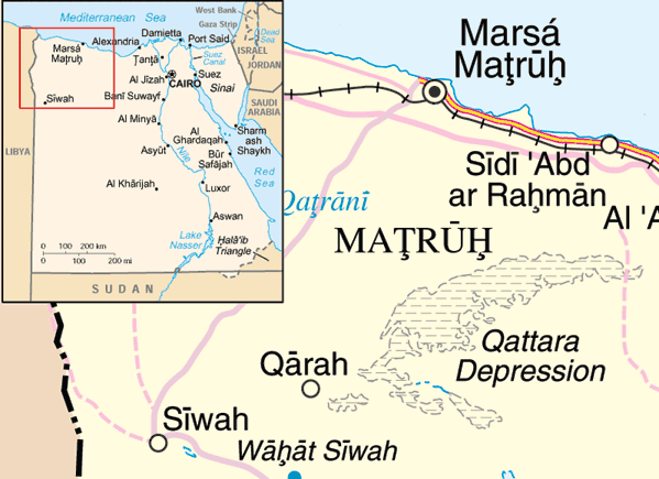
184:Qattara Depression
425:Global file usage
402:
324:2005-05-20 22:10
309:
308:
259:
258:
233:
232:
227:English Knowledge
164:
163:
94:
93:
74:Wikimedia Commons
32:Global file usage
656:
517:Qattaran syvänkö
487:Depresio Kattara
381:
343:
268:
267:
261:
255:
252:
249:
246:
241:
240:
181:
173:
167:
142:
107:
106:
100:
90:
69:
68:
62:
56:
54:
664:
663:
659:
658:
657:
655:
654:
653:
423:
403:
387:
379:
335:
334:
321:
314:
253:
250:
247:
244:
239:
234:
190:
171:
160:
132:
119:vector graphics
104:
96:
95:
84:
83:
82:is shown below.
58:
52:
50:
43:
42:
12:
11:
5:
662:
652:
651:
650:
649:
641:
640:
639:
631:
630:
629:
621:
620:
619:
611:
610:
609:
601:
600:
599:
591:
590:
589:
581:
580:
579:
571:
570:
569:
561:
560:
559:
551:
550:
549:
541:
540:
539:
531:
530:
529:
521:
520:
519:
511:
510:
509:
501:
500:
499:
491:
490:
489:
484:
476:
475:
474:
466:
465:
464:
459:
457:Libyjská poušť
451:
450:
449:
441:
440:
439:
426:
422:
421:
416:
406:
401:
400:
389:
385:
382:
376:
371:
366:
362:
361:
358:
355:
352:
349:
346:
338:
333:
332:
313:
310:
307:
306:
297:
274:United Nations
269:
257:
256:
238:
235:
231:
230:
219:
215:
214:
204:
200:
199:
196:
192:
191:
174:
165:
162:
161:
157:new image name
139:new image name
108:
92:
91:
70:
60:
59:
40:
35:
34:
29:
24:
19:
9:
6:
4:
3:
2:
661:
648:
645:
644:
642:
638:
635:
634:
632:
628:
625:
624:
622:
618:
615:
614:
612:
608:
605:
604:
602:
598:
595:
594:
592:
588:
585:
584:
582:
578:
575:
574:
572:
568:
565:
564:
562:
558:
555:
554:
552:
548:
545:
544:
542:
538:
537:Logán Qattara
535:
534:
532:
528:
525:
524:
522:
518:
515:
514:
512:
508:
505:
504:
502:
498:
495:
494:
492:
488:
485:
483:
480:
479:
477:
473:
470:
469:
467:
463:
460:
458:
455:
454:
452:
448:
447:القاره (واحه)
445:
444:
442:
438:
437:منخفض القطارة
435:
434:
432:
431:
430:
420:
417:
415:
412:
411:
410:
398:
394:
388:
383:
377:
375:
372:
370:
367:
364:
363:
359:
356:
353:
350:
347:
345:
344:
342:
331:
327:
323:
322:
319:
302:
298:
296:
294:
290:
284:
282:
281:
276:
275:
270:
263:
262:
248:Public domain
245:Public domain
243:
242:
228:
224:
220:
216:
213:
209:
206:Adapted from
205:
201:
193:
189:
185:
180:
175:
168:
158:
154:
150:
146:
145:
140:
136:
130:
126:
124:
120:
114:
109:
102:
101:
88:
81:
80:
75:
71:
64:
63:
57:
48:
39:
33:
30:
28:
25:
23:
20:
18:
15:
627:Siwa (oasis)
607:نخلستان سیوہ
428:
408:
340:
337:File history
329:
285:
279:
278:
272:
178:
156:
144:
138:
116:
112:
87:You can help
77:
45:
22:File history
577:စိဝအိုအေစစ်
557:Wahat Siwah
182:Map of the
170:Description
113:locator map
647:Siwa Oasis
567:സിവ ഓയസിസ്
419:Siwa Oasis
414:Qara Oasis
405:File usage
378:599 × 435
354:Dimensions
159:parameter.
27:File usage
597:Оаза Кара
507:واحه قاره
482:Oazo Siva
351:Thumbnail
348:Date/Time
237:Licensing
179:English:
53:image/png
397:en:Egypt
380:(54 KB)
365:current
360:Comment
291:. And:
49:
326:ChrisO
223:ChrisO
218:Author
203:Source
121:as an
117:using
277:map.
254:false
251:false
188:Egypt
111:This
637:锡瓦绿洲
617:Siwa
357:User
318:here
210:and
195:Date
151:(or
125:file
17:File
225:at
153:Vva
123:SVG
395:,
295:.
186:,
141:}}
133:{{
229:.
143:.
137:|
89:.
55:)
Text is available under the Creative Commons Attribution-ShareAlike License. Additional terms may apply.
