394:
881:"}},"text\/plain":{"en":{"":"inception"}}},"{\"value\":{\"time\":\"+2010-05-16T00:00:00Z\",\"timezone\":0,\"before\":0,\"after\":0,\"precision\":11,\"calendarmodel\":\"http:\\\/\\\/www.wikidata.org\\\/entity\\\/Q1985727\"},\"type\":\"time\"}":{"text\/html":{"en":{"P571":"16 May 2010"}},"text\/plain":{"en":{"P571":"16 May 2010"}}}}": -->
43:
407:
659:
375:
283:
288:
99:
679:"}},"text\/plain":{"en":{"P2093":"Carport","P4174":"Carport"}}},"{\"value\":{\"entity-type\":\"property\",\"numeric-id\":4174,\"id\":\"P4174\"},\"type\":\"wikibase-entityid\"}":{"text\/html":{"en":{"":"
427:
667:"}},"text\/plain":{"en":{"":"object of statement has role"}}},"{\"value\":{\"entity-type\":\"item\",\"numeric-id\":33231,\"id\":\"Q33231\"},\"type\":\"wikibase-entityid\"}":{"text\/html":{"en":{"P3831":"
963:"}},"text\/plain":{"en":{"":"media type"}}},"{\"value\":\"image\\\/jpeg\",\"type\":\"string\"}":{"text\/html":{"en":{"P1163":"image\/jpeg"}},"text\/plain":{"en":{"P1163":"image\/jpeg"}}}}": -->
837:"}},"text\/plain":{"en":{"":"copyright license"}}},"{\"value\":{\"entity-type\":\"item\",\"numeric-id\":14946043,\"id\":\"Q14946043\"},\"type\":\"wikibase-entityid\"}":{"text\/html":{"en":{"P275":"
793:"}},"text\/plain":{"en":{"":"copyright status"}}},"{\"value\":{\"entity-type\":\"item\",\"numeric-id\":50423863,\"id\":\"Q50423863\"},\"type\":\"wikibase-entityid\"}":{"text\/html":{"en":{"P6216":"
919:"}},"text\/plain":{"en":{"":"source of file"}}},"{\"value\":{\"entity-type\":\"item\",\"numeric-id\":66458942,\"id\":\"Q66458942\"},\"type\":\"wikibase-entityid\"}":{"text\/html":{"en":{"P7482":"
1654:
683:"}},"text\/plain":{"en":{"":"Wikimedia username"}}},"{\"value\":{\"entity-type\":\"property\",\"numeric-id\":2699,\"id\":\"P2699\"},\"type\":\"wikibase-entityid\"}":{"text\/html":{"en":{"":"
542:"}},"text\/plain":{"en":{"P180":"Saudi Arabia"}}},"{\"value\":{\"entity-type\":\"item\",\"numeric-id\":22656,\"id\":\"Q22656\"},\"type\":\"wikibase-entityid\"}":{"text\/html":{"en":{"P180":"
671:"}},"text\/plain":{"en":{"P3831":"photographer"}}},"{\"value\":{\"entity-type\":\"property\",\"numeric-id\":2093,\"id\":\"P2093\"},\"type\":\"wikibase-entityid\"}":{"text\/html":{"en":{"":"
546:"}},"text\/plain":{"en":{"P180":"petroleum"}}},"{\"value\":{\"entity-type\":\"item\",\"numeric-id\":42962,\"id\":\"Q42962\"},\"type\":\"wikibase-entityid\"}":{"text\/html":{"en":{"P180":"
550:"}},"text\/plain":{"en":{"P180":"oil"}}},"{\"value\":{\"entity-type\":\"item\",\"numeric-id\":741935,\"id\":\"Q741935\"},\"type\":\"wikibase-entityid\"}":{"text\/html":{"en":{"P180":"
663:"}},"text\/plain":{"en":{"":"creator"}}},"{\"value\":{\"entity-type\":\"property\",\"numeric-id\":3831,\"id\":\"P3831\"},\"type\":\"wikibase-entityid\"}":{"text\/html":{"en":{"":"
538:"}},"text\/plain":{"en":{"":"depicts"}}},"{\"value\":{\"entity-type\":\"item\",\"numeric-id\":851,\"id\":\"Q851\"},\"type\":\"wikibase-entityid\"}":{"text\/html":{"en":{"P180":"
959:
675:"}},"text\/plain":{"en":{"":"author name string"}}},"{\"value\":\"Carport\",\"type\":\"string\"}":{"text\/html":{"en":{"P2093":"Carport","P4174":"
687:"}},"text\/plain":{"en":{"":"URL"}}},"{\"value\":\"http:\\\/\\\/commons.wikimedia.org\\\/wiki\\\/User:Carport\",\"type\":\"string\"}":{"text\/html":{"en":{"P2699":"
1659:
1649:
1704:
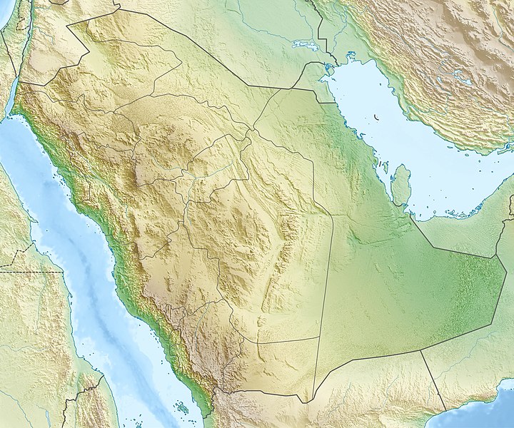
1056:{{Information |Description={{de|Physische Positionskarte von {{w|Saudi-Arabien|3=de}}}} Quadratische Plattkarte, N-S-Streckung 110 %. Geographische Begrenzung der Karte: * N: 32.5° N * S: 16.0° N * W: 34.2° O * O: 56.0° O {{en|Physical location map of
1874:
329:– You must give appropriate credit, provide a link to the license, and indicate if changes were made. You may do so in any reasonable manner, but not in any way that suggests the licensor endorses you or your use.
1859:
676:
1679:
1669:
1644:
1576:
1067:
1664:
920:
838:
794:
688:
551:
668:
547:
543:
960:
916:
790:
684:
680:
672:
664:
504:
878:
834:
660:
539:
535:
1888:
1629:
385:
65:
61:
57:
53:
47:
110:
78:
1049:
841:"}},"text\/plain":{"en":{"P275":"Creative Commons Attribution-ShareAlike 3.0 Unported"}}}}": -->
691:"}},"text\/plain":{"en":{"P2699":"http:\/\/commons.wikimedia.org\/wiki\/User:Carport"}}}}": -->
266:
470:
and remove this tag. This tag should not be applied to photographs or scans. If this image is a diagram or other image suitable for
946:
864:
820:
1899:
This file contains additional information, probably added from the digital camera or scanner used to create or digitize it.
1764:
631:
336:
732:
614:
597:
1374:
970:
930:
804:
768:
753:
740:
725:
923:"}},"text\/plain":{"en":{"P7482":"original creation by uploader"}}}}": -->
888:
848:
698:
580:
564:
1554:
1394:
1389:
1154:
406:
1564:
1479:
1369:
1499:
1634:
1384:
149:
1284:
393:
760:
298:
1694:
1099:
1902:
If the file has been modified from its original state, some details may not fully reflect the modified file.
1729:
1624:
1066:
More than 100 pages use this file. The following list shows the first 100 pages that use this file only. A
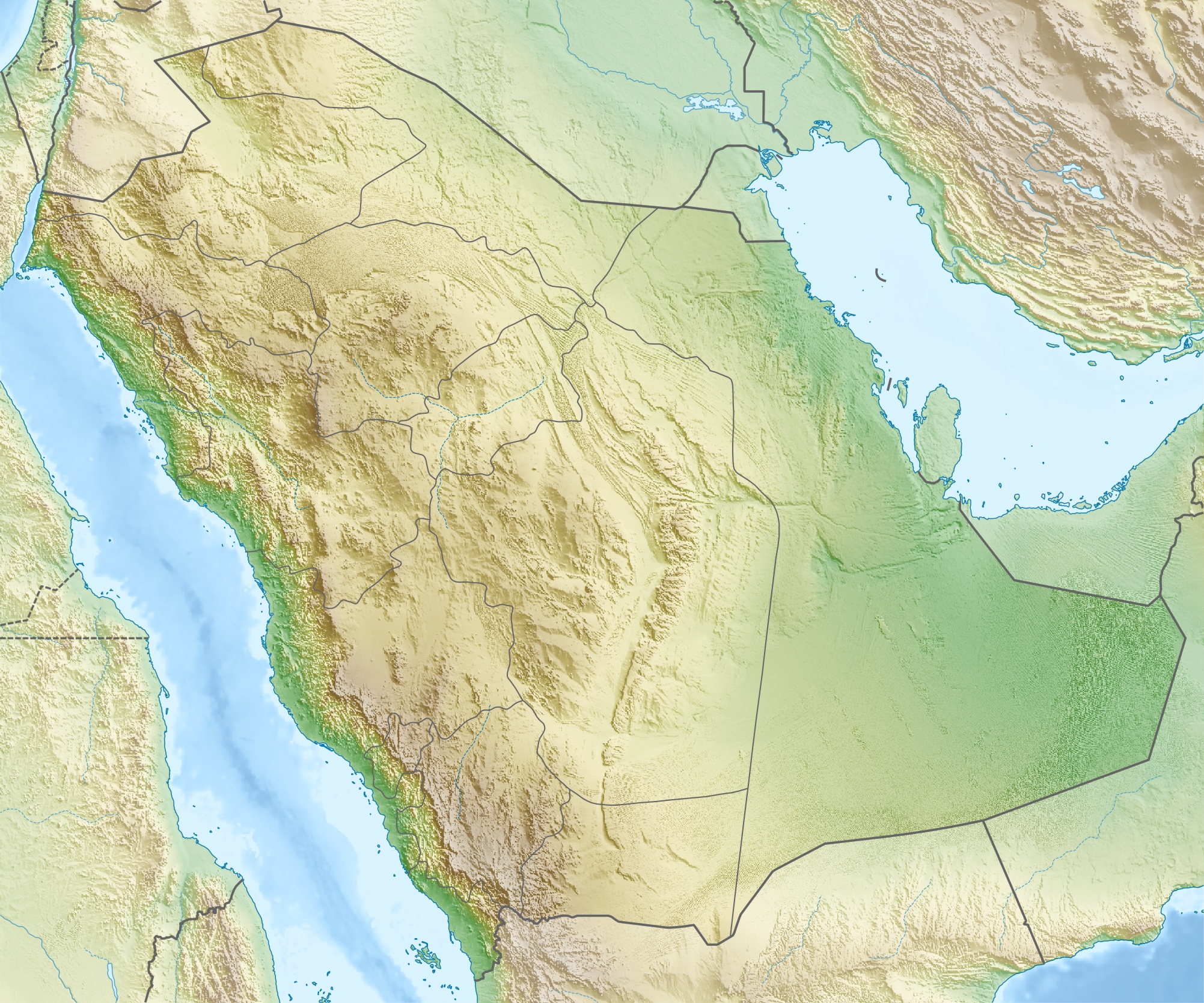
247:, using map data from administrative map by NordNordWest. The relief was created from SRTM-30 relief data.
1689:
335:– If you remix, transform, or build upon the material, you must distribute your contributions under the
1079:
1879:
1038:
1033:
69:
42:
1639:
1514:
1074:
797:"}},"text\/plain":{"en":{"P6216":"copyrighted"}}}}": -->
554:"}},"text\/plain":{"en":{"P180":"Ghawar Field"}}}}": -->
1614:
1869:
1264:
1234:
1159:
1109:
487:
475:
1549:
1364:
118:
1864:
1489:
1309:
1219:
155:إسقاط متساوي المستطيلات (الإسقاط الجغرافي)، شمال / جنوب امتداد 110٪. الحدود الجغرافية للخريطة:
1464:
1169:
1089:
459:
775:
1524:
1204:
295:
1469:
8:
1419:
1674:
1434:
1324:
1199:
183:
Quadratische
Plattkarte, N-S-Streckung 110 %. Geographische Begrenzung der Karte:
1744:
1519:
1509:
1459:
1354:
1224:
1189:
493:
481:
471:
211:
Equirectangular projection, N/S stretching 110 %. Geographic limits of the map:
105:
1329:
1209:
1534:
1409:
1399:
1184:
1084:
178:
1604:
1294:
1849:
1414:
1279:
1249:
1239:
1164:
1144:
1504:
1379:
1334:
1274:
1244:
1194:
1179:
1174:
1739:
1774:
1529:
1474:
1359:
1319:
1314:
1134:
1104:
255:
206:
1754:
1724:
1594:
1769:
1439:
1404:
1299:
1289:
1254:
433:
1789:
1094:
980:
940:
898:
858:
814:
708:
642:
625:
608:
591:
574:
1794:
1569:
1449:
1304:
446:. This information could be stored more efficiently or accurately in the
374:
1484:
1454:
1444:
1259:
438:
1759:
1719:
458:
If possible, please upload a PNG or SVG version of this image without
1619:
1344:
1214:
1119:
452:
448:
1839:
1834:
1269:
1149:
1139:
1124:
1114:
1006:
Click on a date/time to view the file as it appeared at that time.
463:
1799:
1229:
1749:
1714:
1819:
1559:
1494:
1429:
1424:
1339:
1129:
1804:
1829:
1824:
1779:
1544:
1349:
462:, derived from a non-JPEG source (or with existing artifacts
1655:محطة الشعيبة لتحلية المياه المالحة وتوليد الطاقة الكهربائية
1539:
234:
93:
1814:
528:
Add a one-line explanation of what this file represents
83:(2,003 × 1,668 pixels, file size: 1.67 MB, MIME type:
1695:
Módulu:Mapa de llocalización/datos/Arabia
Saudita/usu
1064:
1585:
1004:
865:
Creative
Commons Attribution-ShareAlike 3.0 Unported
839:
Creative
Commons Attribution-ShareAlike 3.0 Unported
466:). After doing so, please tag the JPEG version with
117:
Commons is a freely licensed media file repository.
1809:
689:http:\/\/commons.wikimedia.org\/wiki\/User:Carport
1784:
1690:Módulu:Mapa de llocalización/datos/Arabia Saudita
386:Saudi Arabia relief location map (cropped).jpg
346:https://creativecommons.org/licenses/by-sa/3.0
98:
352:Creative Commons Attribution-Share Alike 3.0
276:
261:
230:
135:
365:
251:
240:
14:
312:– to copy, distribute and transmit the work
1660:محطة رأس الخير لتحلية المياه وإنتاج الطاقة
1587:The following other wikis use this file:
776:http://commons.wikimedia.org/User:Carport
486:. If not suitable for vectorisation, use
1765:Şablon:Yer xəritəsi Səudiyyə Ərəbistanı
1650:مستخدم:عبد المؤمن/مسودات/خرائط/السعودية
1705:Шаблон:БакІКарта СагІудиязул ГІарабия
129:
1605:Vorlage:Positionskarte Saudi-Arabien
421:
369:
299:Attribution-Share Alike 3.0 Unported
138:Saudi Arabia relief location map.jpg
1850:Vorlog:Positionskarte Saudi-Arabien
1375:King Abdullah bin Abdulaziz Airport
997:
287:
282:
13:
1897:
533:
527:
502:
273:
199:
171:
142:
130:
76:
1923:
1904:
1680:كأس خادم الحرمين الشريفين 2023–24
1555:Umm Al Melh Border Guards Airport
1500:Rock Art in the Ha'il Region
1395:King Khalid International Airport
1390:King Khaled Military City Airport
1155:Al Qaisumah/Hafr Al Batin Airport
532:
444:consists of non-photographic data
1875:Ҡалып:ПозКарта Саудовская Аравия
1730:شابلون:Location map Saudi Arabia
1565:Wadi al-Dawasir Domestic Airport
1480:Qatif and Dammam mosque bombings
1370:King Abdulaziz Historical Center
518:
425:
405:
392:
373:
323:Under the following conditions:
294:This file is licensed under the
286:
281:
275:
97:
31:
21:
1385:King Fahd International Airport
515:
200:
1595:Pola:Location map Saudi Arabia
1582:
1285:Imam Turki bin Abdullah Mosque
1001:
514:
172:
143:
26:
1:
1670:متنزه الغاط الوطني (السعودية)
1100:Al-Ahsa International Airport
947:original creation by uploader
921:original creation by uploader
474:, please tag this image with
412:Equivalent administrative map
177:Physische Positionskarte von
36:
1860:Ғәрәбстан ярымутрауы сүлдәре
1075:'Uruq Bani Ma'arid
1061:
726:object of statement has role
665:object of statement has role
560:Items portrayed in this file
492:. For more information, see
7:
1894:
1846:Usage on bar.wikipedia.org
1711:Usage on azb.wikipedia.org
1686:Usage on ast.wikipedia.org
1601:Usage on als.wikipedia.org
1591:Usage on ace.wikipedia.org
468:{{Superseded|NewImage.ext}}
10:
1928:
1856:Usage on ba.wikipedia.org
1736:Usage on az.wikipedia.org
1701:Usage on av.wikipedia.org
1665:منفذ جديدة عرعر (السعودية)
1611:Usage on ar.wikipedia.org
1080:Abha International Airport
337:same or compatible license
132:
1515:Sharurah Domestic Airport
998:
244:
205:Physical location map of
16:
1645:الحرب العثمانية السعودية
1265:Gurayat Domestic Airport
1235:Dawadmi Domestic Airport
1160:Al Wajh Domestic Airport
1110:Al-Baha Domestic Airport
517:
303:
104:This is a file from the
41:
1550:Turaif Domestic Airport
1365:King Abdulaziz Air Base
1055:
424:
372:
233:
108:. Information from its
1490:Rafha Domestic Airport
1220:Bisha Domestic Airport
507:
442:format even though it
111:description page there
46:Size of this preview:
1470:Prophet's Mosque
1465:Nakhla (Saudi Arabia)
1310:Jabal Umm Hayfā'
1170:Arar Domestic Airport
1090:Abu Qubays (mountain)
506:
460:compression artifacts
1745:Ərəbistan yarımadası
1630:متنزه الأحساء الوطني
1525:Siege of Mecca (683)
1205:Battle of the Trench
70:2,003 × 1,668 pixels
66:1,230 × 1,024 pixels
1790:Şablon:Yarımada/doc
1420:Masjid al-Qiblatayn
318:– to adapt the work
52:Other resolutions:
1835:Farasan arxipelaqı
1435:Mina, Saudi Arabia
1325:Jabal an Nukhaylah
1210:Bay'ah Mosque
1200:Battle of al-Harra
1034:17:28, 16 May 2010
754:Wikimedia username
741:author name string
681:Wikimedia username
673:author name string
508:
489:{{Convert to PNG}}
477:{{Convert to SVG}}
162:جنوب: 16.0° شمالاً
159:شمال: 32.5° شمالاً
1915:
1914:
1889:more global usage
1583:Global file usage
1520:Shaybah oil field
1510:Sarawat Mountains
1460:Najran Valley Dam
1355:Khurais oil field
1295:Jabal Natfa'
1225:Conquest of Mecca
1190:Battle of Khaybar
1059:
849:copyright license
835:copyright license
526:
512:
511:
499:
419:
418:
401:
400:
380:This file has an
270:
267:Reusing this file
126:
125:
106:Wikimedia Commons
32:Global file usage
1919:
1905:
1535:Sitae Alhven Dam
1410:Masjid Al-Taneem
1400:King Saud Mosque
1185:Battle of Fakhkh
1085:Abqaiq oil field
1046:
1008:
805:copyright status
791:copyright status
778:
773:
763:
758:
748:
745:
735:
730:
524:
505:
496:
490:
484:
478:
469:
457:
432:This image was
429:
428:
422:
409:
396:
377:
370:
359:
356:
353:
350:
347:
339:as the original.
296:Creative Commons
290:
289:
285:
284:
279:
278:
264:
246:
236:
204:
176:
168:شرق: 56.0° شرقاً
165:غرب: 34.2° شرقاً
147:
139:
133:
122:
101:
100:
94:
88:
86:
73:
62:922 × 768 pixels
58:577 × 480 pixels
54:288 × 240 pixels
48:720 × 600 pixels
1927:
1926:
1922:
1921:
1920:
1918:
1917:
1916:
1893:
1760:Şablon:Yarımada
1581:
1415:Masjid al-Haram
1280:Hijaz Mountains
1250:Farasan Islands
1240:Dumat al-Jandal
1165:Anbariya Mosque
1145:Al Jouf Airport
1060:
1052:
1044:
1000:
999:
996:
995:
994:
993:
992:
991:
990:
989:
987:
977:
976:
975:
973:
958:
957:
956:
955:
954:
953:
952:
951:
949:
937:
936:
935:
933:
914:
913:
912:
911:
910:
909:
908:
907:
905:
895:
894:
893:
891:
876:
875:
874:
873:
872:
871:
870:
869:
867:
855:
854:
853:
851:
832:
831:
830:
829:
828:
827:
826:
825:
823:
811:
810:
809:
807:
788:
787:
786:
785:
784:
783:
782:
781:
780:
779:
774:
771:
765:
764:
759:
756:
750:
749:
746:
743:
737:
736:
731:
728:
719:
718:
717:
715:
705:
704:
703:
701:
658:
657:
656:
655:
654:
653:
652:
651:
649:
640:
639:
638:
637:
636:
634:
623:
622:
621:
620:
619:
617:
606:
605:
604:
603:
602:
600:
589:
588:
587:
586:
585:
583:
571:
570:
569:
567:
531:
530:
529:
503:
494:
488:
482:
476:
467:
426:
420:
413:
410:
397:
382:extracted image
361:
360:
357:
354:
351:
348:
345:
344:
302:
291:
209:
181:
153:
137:
128:
127:
116:
115:
114:is shown below.
90:
84:
82:
75:
74:
51:
12:
11:
5:
1925:
1913:
1912:
1909:
1896:
1891:of this file.
1885:
1884:
1883:
1882:
1877:
1872:
1867:
1862:
1854:
1853:
1852:
1844:
1843:
1842:
1837:
1832:
1827:
1822:
1817:
1812:
1807:
1802:
1797:
1792:
1787:
1782:
1777:
1772:
1767:
1762:
1757:
1752:
1747:
1742:
1734:
1733:
1732:
1727:
1722:
1717:
1709:
1708:
1707:
1699:
1698:
1697:
1692:
1684:
1683:
1682:
1677:
1672:
1667:
1662:
1657:
1652:
1647:
1642:
1637:
1632:
1627:
1622:
1617:
1609:
1608:
1607:
1599:
1598:
1597:
1584:
1579:to this file.
1573:
1572:
1567:
1562:
1557:
1552:
1547:
1542:
1537:
1532:
1527:
1522:
1517:
1512:
1507:
1505:Safa and Marwa
1502:
1497:
1492:
1487:
1482:
1477:
1472:
1467:
1462:
1457:
1452:
1447:
1442:
1437:
1432:
1427:
1422:
1417:
1412:
1407:
1402:
1397:
1392:
1387:
1382:
1380:King Fahad Dam
1377:
1372:
1367:
1362:
1357:
1352:
1347:
1342:
1337:
1335:Jawatha Mosque
1332:
1330:Jabal ʽUmayyid
1327:
1322:
1317:
1312:
1307:
1302:
1297:
1292:
1287:
1282:
1277:
1275:Harrat Khaybar
1272:
1267:
1262:
1257:
1252:
1247:
1245:Farasan Island
1242:
1237:
1232:
1227:
1222:
1217:
1212:
1207:
1202:
1197:
1195:Battle of Uhud
1192:
1187:
1182:
1180:Battle of Badr
1177:
1175:Asir Mountains
1172:
1167:
1162:
1157:
1152:
1147:
1142:
1137:
1132:
1127:
1122:
1117:
1112:
1107:
1102:
1097:
1092:
1087:
1082:
1077:
1070:is available.
1063:
1058:
1057:
1054:
1050:
1047:
1043:2,003 × 1,668
1041:
1036:
1031:
1027:
1026:
1023:
1020:
1017:
1014:
1011:
1003:
988:
985:
983:
982:
981:
979:
978:
974:
969:
967:
966:
965:
964:
962:
950:
945:
943:
942:
941:
939:
938:
934:
931:source of file
929:
927:
926:
925:
924:
922:
918:
917:source of file
906:
903:
901:
900:
899:
897:
896:
892:
887:
885:
884:
883:
882:
880:
868:
863:
861:
860:
859:
857:
856:
852:
847:
845:
844:
843:
842:
840:
836:
824:
819:
817:
816:
815:
813:
812:
808:
803:
801:
800:
799:
798:
796:
792:
767:
766:
752:
751:
739:
738:
724:
723:
722:
721:
720:
716:
713:
711:
710:
709:
707:
706:
702:
697:
695:
694:
693:
692:
690:
686:
682:
678:
674:
670:
666:
662:
650:
647:
645:
644:
643:
641:
635:
630:
628:
627:
626:
624:
618:
613:
611:
610:
609:
607:
601:
596:
594:
593:
592:
590:
584:
579:
577:
576:
575:
573:
572:
568:
563:
561:
558:
557:
556:
555:
553:
549:
545:
541:
537:
523:
522:
519:
516:
510:
509:
500:
430:
417:
416:
415:
414:
411:
404:
399:
398:
391:
389:
378:
367:
366:Other versions
363:
362:
343:
342:
341:
340:
330:
321:
320:
319:
313:
306:You are free:
293:
292:
274:
271:
259:
258:
253:
249:
248:
242:
238:
237:
232:
228:
227:
226:
225:
222:
219:
216:
198:
197:
194:
191:
188:
170:
169:
166:
163:
160:
140:
131:
124:
123:
102:
92:
91:
45:
40:
39:
34:
29:
24:
19:
9:
6:
4:
3:
2:
1924:
1910:
1907:
1906:
1903:
1900:
1892:
1890:
1881:
1878:
1876:
1873:
1871:
1868:
1866:
1863:
1861:
1858:
1857:
1855:
1851:
1848:
1847:
1845:
1841:
1840:Ayneyn təpəsi
1838:
1836:
1833:
1831:
1828:
1826:
1823:
1821:
1820:Sanafir adası
1818:
1816:
1813:
1811:
1808:
1806:
1803:
1801:
1798:
1796:
1795:Dəhnə (səhra)
1793:
1791:
1788:
1786:
1783:
1781:
1778:
1776:
1773:
1771:
1768:
1766:
1763:
1761:
1758:
1756:
1753:
1751:
1748:
1746:
1743:
1741:
1740:Qırmızı dəniz
1738:
1737:
1735:
1731:
1728:
1726:
1723:
1721:
1718:
1716:
1713:
1712:
1710:
1706:
1703:
1702:
1700:
1696:
1693:
1691:
1688:
1687:
1685:
1681:
1678:
1676:
1673:
1671:
1668:
1666:
1663:
1661:
1658:
1656:
1653:
1651:
1648:
1646:
1643:
1641:
1638:
1636:
1635:سد وادي جازان
1633:
1631:
1628:
1626:
1623:
1621:
1618:
1616:
1613:
1612:
1610:
1606:
1603:
1602:
1600:
1596:
1593:
1592:
1590:
1589:
1588:
1580:
1578:
1571:
1568:
1566:
1563:
1561:
1558:
1556:
1553:
1551:
1548:
1546:
1543:
1541:
1538:
1536:
1533:
1531:
1530:Simon Cumbers
1528:
1526:
1523:
1521:
1518:
1516:
1513:
1511:
1508:
1506:
1503:
1501:
1498:
1496:
1493:
1491:
1488:
1486:
1483:
1481:
1478:
1476:
1475:Qaryat al-Faw
1473:
1471:
1468:
1466:
1463:
1461:
1458:
1456:
1453:
1451:
1448:
1446:
1443:
1441:
1438:
1436:
1433:
1431:
1428:
1426:
1423:
1421:
1418:
1416:
1413:
1411:
1408:
1406:
1403:
1401:
1398:
1396:
1393:
1391:
1388:
1386:
1383:
1381:
1378:
1376:
1373:
1371:
1368:
1366:
1363:
1361:
1360:Khuzam Palace
1358:
1356:
1353:
1351:
1348:
1346:
1343:
1341:
1338:
1336:
1333:
1331:
1328:
1326:
1323:
1321:
1320:Jabal al-Nour
1318:
1316:
1315:Jabal al-Lawz
1313:
1311:
1308:
1306:
1303:
1301:
1298:
1296:
1293:
1291:
1288:
1286:
1283:
1281:
1278:
1276:
1273:
1271:
1268:
1266:
1263:
1261:
1258:
1256:
1253:
1251:
1248:
1246:
1243:
1241:
1238:
1236:
1233:
1231:
1228:
1226:
1223:
1221:
1218:
1216:
1213:
1211:
1208:
1206:
1203:
1201:
1198:
1196:
1193:
1191:
1188:
1186:
1183:
1181:
1178:
1176:
1173:
1171:
1168:
1166:
1163:
1161:
1158:
1156:
1153:
1151:
1148:
1146:
1143:
1141:
1138:
1136:
1135:Al-Wadiah War
1133:
1131:
1128:
1126:
1123:
1121:
1118:
1116:
1113:
1111:
1108:
1106:
1105:Al-Ahsa Oasis
1103:
1101:
1098:
1096:
1095:Al-Abwa'
1093:
1091:
1088:
1086:
1083:
1081:
1078:
1076:
1073:
1072:
1071:
1069:
1053:
1048:
1042:
1040:
1037:
1035:
1032:
1029:
1028:
1024:
1021:
1018:
1015:
1012:
1010:
1009:
1007:
984:
972:
968:
948:
944:
932:
928:
902:
890:
886:
866:
862:
850:
846:
822:
818:
806:
802:
777:
770:
762:
755:
742:
734:
727:
712:
700:
696:
646:
633:
629:
616:
612:
599:
595:
582:
578:
566:
562:
559:
520:
513:
501:
497:
491:
485:
479:
473:
472:vectorisation
465:
461:
455:
454:
450:
445:
441:
440:
435:
431:
423:
408:
403:
402:
395:
390:
387:
383:
379:
376:
371:
368:
364:
349:CC BY-SA 3.0
338:
334:
331:
328:
325:
324:
322:
317:
314:
311:
308:
307:
305:
304:
300:
297:
280:
272:
268:
263:
260:
257:
254:
250:
243:
239:
229:
223:
220:
217:
214:
213:
212:
208:
203:
195:
192:
189:
186:
185:
184:
180:
179:Saudi-Arabien
175:
167:
164:
161:
158:
157:
156:
151:
146:
141:
134:
120:
113:
112:
107:
103:
96:
95:
89:
80:
79:Original file
71:
67:
63:
59:
55:
49:
44:
38:
35:
33:
30:
28:
25:
23:
20:
18:
15:
1901:
1898:
1886:
1880:Ғәкәбә (уба)
1775:Ərəb səhrası
1625:معمل غاز حرض
1586:
1574:
1440:Mount Arafat
1405:Layla (town)
1300:Jabal Soudah
1290:Jabal Atherb
1255:Ghawar Field
1065:
1005:
1002:File history
733:photographer
669:photographer
632:Ghawar Field
581:Saudi Arabia
552:Ghawar Field
540:Saudi Arabia
447:
443:
437:
381:
332:
326:
315:
309:
210:
207:Saudi Arabia
201:
182:
173:
154:
148:خريطة مواقع
144:
119:You can help
109:
77:
22:File history
1865:Мина (үҙән)
1830:Karan adası
1825:Tiran adası
1800:Böyük Nefud
1780:Rub əl-Xali
1755:Ərəfat dağı
1640:سد وادي بيش
1570:Wahhabi War
1450:Murwani Dam
1305:Jabal Thawr
904:16 May 2010
821:copyrighted
795:copyrighted
495:{{BadJPEG}}
483:{{BadJPEG}}
480:instead of
333:share alike
327:attribution
235:16 May 2010
136:Description
1908:_error
1770:Əl-Ərəbiyə
1615:حقل الغوار
1577:more links
1485:Rabigh Dam
1455:Muzdalifah
1445:Mount Uhud
1260:Green Dome
1062:File usage
1019:Dimensions
986:image/jpeg
971:media type
961:media type
714:some value
648:some value
262:Permission
224:E: 56.0° E
221:W: 34.2° E
218:S: 16.0° N
215:N: 32.5° N
196:O: 56,0° O
193:W: 34,2° O
190:S: 16,0° N
187:N: 32,5° N
85:image/jpeg
27:File usage
1870:Мөздәлифә
1750:Mina dağı
1345:Jizan Dam
1215:Baysh Dam
1120:Al-Manifa
1068:full list
1045:(1.67 MB)
1016:Thumbnail
1013:Date/Time
889:inception
879:inception
598:petroleum
544:petroleum
202:English:
174:Deutsch:
145:العربية:
1895:Metadata
1675:عين حنين
1270:Hali Dam
1150:Al Khayf
1140:Al Bahah
1125:Al-Namas
1115:Al-Magar
521:Captions
456:format.
434:uploaded
316:to remix
310:to share
301:license.
245:Own work
150:السعودية
37:Metadata
1805:Əl-Əhsa
1230:Dawadmi
1051:Carport
1030:current
1025:Comment
761:Carport
747:Carport
699:creator
677:Carport
661:creator
565:depicts
536:depicts
525:English
464:removed
436:in the
256:Carport
81:
1815:Tihamə
1810:Cafura
1560:Uyayna
1495:Riyadh
1430:Midian
1425:Medina
1340:Jeddah
1130:Al-Ula
252:Author
241:Source
1887:View
1725:مدینه
1575:View
1545:Tayma
1350:Kaaba
1785:Hira
1720:ریاض
1620:جرول
1540:Taif
1022:User
439:JPEG
358:true
355:true
231:Date
17:File
1715:مکه
769:URL
685:URL
615:oil
548:oil
453:SVG
451:or
449:PNG
772::
757::
744::
729::
384::
68:|
64:|
60:|
56:|
50:.
1911:0
498:.
388:.
269:)
265:(
152:.
121:.
87:)
72:.
Text is available under the Creative Commons Attribution-ShareAlike License. Additional terms may apply.
.jpg)
