43:
536:"}},"text\/plain":{"en":{"":"coordinates of the point of view"}}},"{\"value\":{\"latitude\":-44.814528,\"longitude\":168.128056,\"altitude\":null,\"precision\":1.0e-6,\"globe\":\"http:\\\/\\\/www.wikidata.org\\\/entity\\\/Q2\"},\"type\":\"globecoordinate\"}":{"text\/html":{"en":{"P1259":"44\u00b048'52.301"S, 168\u00b07'41.002"E"}},"text\/plain":{"en":{"P1259":"44\u00b048'52.301\"S, 168\u00b07'41.002\"E"}}}}": -->
498:"}},"text\/plain":{"en":{"":"inception"}}},"{\"value\":{\"time\":\"+2016-01-09T00:00:00Z\",\"timezone\":0,\"before\":0,\"after\":0,\"precision\":11,\"calendarmodel\":\"http:\\\/\\\/www.wikidata.org\\\/entity\\\/Q1985727\"},\"type\":\"time\"}":{"text\/html":{"en":{"P571":"9 January 2016"}},"text\/plain":{"en":{"P571":"9 January 2016"}}}}": -->
245:
212:
226:
251:
103:
746:"}},"text\/plain":{"en":{"":"ISO speed"}}},"{\"value\":{\"amount\":\"+400\",\"unit\":\"1\"},\"type\":\"quantity\"}":{"text\/html":{"en":{"P6789":"400"}},"text\/plain":{"en":{"P6789":"400"}}}}": -->
618:"}},"text\/plain":{"en":{"":"exposure time"}}},"{\"value\":{\"amount\":\"+0.00181818181818181818\",\"unit\":\"http:\\\/\\\/www.wikidata.org\\\/entity\\\/Q11574\"},\"type\":\"quantity\"}":{"text\/html":{"en":{"P6757":"0.00181818181818181818
663:"}},"text\/plain":{"en":{"":"f-number"}}},"{\"value\":{\"amount\":\"+8\",\"unit\":\"1\"},\"type\":\"quantity\"}":{"text\/html":{"en":{"P6790":"8"}},"text\/plain":{"en":{"P6790":"8"}}}}": -->
866:
410:"}},"text\/plain":{"en":{"":"copyright license"}}},"{\"value\":{\"entity-type\":\"item\",\"numeric-id\":20007257,\"id\":\"Q20007257\"},\"type\":\"wikibase-entityid\"}":{"text\/html":{"en":{"P275":"
366:"}},"text\/plain":{"en":{"":"copyright status"}}},"{\"value\":{\"entity-type\":\"item\",\"numeric-id\":50423863,\"id\":\"Q50423863\"},\"type\":\"wikibase-entityid\"}":{"text\/html":{"en":{"P6216":"
574:"}},"text\/plain":{"en":{"":"source of file"}}},"{\"value\":{\"entity-type\":\"item\",\"numeric-id\":66458942,\"id\":\"Q66458942\"},\"type\":\"wikibase-entityid\"}":{"text\/html":{"en":{"P7482":"
701:"}},"text\/plain":{"en":{"":"focal length"}}},"{\"value\":{\"amount\":\"+18\",\"unit\":\"http:\\\/\\\/www.wikidata.org\\\/entity\\\/Q174789\"},\"type\":\"quantity\"}":{"text\/html":{"en":{"P2151":"18
454:"}},"text\/plain":{"en":{"":"captured with"}}},"{\"value\":{\"entity-type\":\"item\",\"numeric-id\":313878,\"id\":\"Q313878\"},\"type\":\"wikibase-entityid\"}":{"text\/html":{"en":{"P4082":"
784:"}},"text\/plain":{"en":{"":"instance of"}}},"{\"value\":{\"entity-type\":\"item\",\"numeric-id\":125191,\"id\":\"Q125191\"},\"type\":\"wikibase-entityid\"}":{"text\/html":{"en":{"P31":"
742:
298:– You must give appropriate credit, provide a link to the license, and indicate if changes were made. You may do so in any reasonable manner, but not in any way that suggests the licensor endorses you or your use.
209:
69:
65:
61:
57:
53:
47:
114:
82:
575:
411:
367:
785:
455:
743:
698:
660:
615:
571:
533:
451:
363:
495:
407:
781:
876:
414:"}},"text\/plain":{"en":{"P275":"Creative Commons Attribution 4.0 International"}}}}": -->
601:
437:
393:
219:
865:
860:
73:
42:
887:|Source={{Own}} |Date=2016-01-09 |Author={{user at project|Pseudopanax|wikipedia|en}} }} {{location|44|48|52.3|S|168|7|41|...
942:
This file contains additional information, probably added from the digital camera or scanner used to create or digitize it.
811:
481:
753:
712:
670:
629:
585:
543:
465:
377:
622:"}},"text\/plain":{"en":{"P6757":"0.00181818181818181818 second"}}}}": -->
578:"}},"text\/plain":{"en":{"P7482":"original creation by uploader"}}}}": -->
505:
421:
352:
795:
1079:
945:
If the file has been modified from its original state, some details may not fully reflect the modified file.
458:"}},"text\/plain":{"en":{"P4082":"Fujifilm X-Pro1"}}}}": -->
261:
705:"}},"text\/plain":{"en":{"P2151":"18 millimetre"}}}}": -->
370:"}},"text\/plain":{"en":{"P6216":"copyrighted"}}}}": -->
788:"}},"text\/plain":{"en":{"P31":"photograph"}}}}": -->
122:
1153:
182:
258:
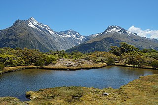
883:== {{int:filedesc}} == {{Information |Description=Tarn at Key Summit, a side track on the
8:
1189:
225:
109:
342:
152:
901:
884:
1281:
1171:
1127:
971:
1011:
805:
763:
722:
680:
639:
595:
553:
515:
475:
431:
387:
1207:
1048:
991:
1307:
981:
954:
833:
Click on a date/time to view the file as it appeared at that time.
211:
964:
929:
204:
44° 48′ 52.3″ S, 168° 07′ 41″ E
186:
919:
147:
Tarn at Key Summit, a side track on the
Routeburn Track.jpg
162:
97:
336:
Add a one-line explanation of what this file represents
87:(4,896 × 3,264 pixels, file size: 7.26 MB, MIME type:
895:
910:
831:
121:
Commons is a freely licensed media file repository.
1194:Flash did not fire, compulsory flash suppression
438:Creative Commons Attribution 4.0 International
412:Creative Commons Attribution 4.0 International
102:
244:
158:
144:
178:
168:
14:
702:
619:
305:https://creativecommons.org/licenses/by/4.0
281:– to copy, distribute and transmit the work
912:The following other wikis use this file:
151:Tarn at Key Summit, a side track on the
218:View this and other nearby images on:
133:
194:
897:The following page uses this file:
824:
250:
13:
940:
341:
335:
272:
241:
134:
80:
1332:
947:
340:
311:Creative Commons Attribution 4.0
1002:Date and time of data generation
544:coordinates of the point of view
534:coordinates of the point of view
326:
292:Under the following conditions:
257:This file is licensed under the
249:
243:
224:
210:
101:
31:
21:
323:
976:1/550 sec (0.0018181818181818)
907:
828:
559:44°48'52.301"S, 168°7'41.002"E
322:
26:
1:
1260:A directly photographed image
602:original creation by uploader
576:original creation by uploader
262:Attribution 4.0 International
36:
892:
348:Items portrayed in this file
237:
7:
1233:Focal plane resolution unit
1090:Date and time of digitizing
937:
926:Usage on de.wikivoyage.org
10:
1337:
1291:Focal length in 35 mm film
1244:One-chip color area sensor
1199:Supported Flashpix version
916:Usage on an.wikipedia.org
141:
136:
1098:Meaning of each component
1055:File change date and time
825:
172:
16:
1225:Focal plane Y resolution
1217:Focal plane X resolution
325:
108:This is a file from the
41:
1265:Custom image processing
882:
645:0.00181818181818181818
230:-44.814528; 168.128056
161:
112:. Information from its
1317:Subject distance range
1119:Image compression mode
1058:09:53, 1 February 2016
115:description page there
46:Size of this preview:
1163:Maximum land aperture
1093:14:12, 9 January 2016
1029:Horizontal resolution
1005:14:12, 9 January 2016
861:03:13, 18 August 2016
269:Pseudopanax@Wikimedia
1286:Manual white balance
1252:Digital still camera
74:4,896 × 3,264 pixels
70:2,560 × 1,707 pixels
1063:Y and C positioning
1037:Vertical resolution
951:Camera manufacturer
287:– to adapt the work
52:Other resolutions:
1299:Scene capture type
66:1,280 × 853 pixels
62:1,024 × 683 pixels
1324:
1323:
1166:3.6 APEX (f/3.48)
1074:Aperture priority
908:Global file usage
890:
704:
621:
422:copyright license
408:copyright license
334:
235:
234:
192:
191:
187:English Knowledge
130:
129:
110:Wikimedia Commons
32:Global file usage
1328:
1071:Exposure Program
948:
873:
835:
731:
648:
378:copyright status
364:copyright status
332:
318:
315:
312:
309:
306:
270:
259:Creative Commons
253:
252:
247:
246:
231:
228:
214:
213:
207:
206:
195:
174:
164:
148:
142:
126:
105:
104:
98:
92:
90:
77:
58:640 × 427 pixels
54:320 × 213 pixels
48:800 × 533 pixels
1336:
1335:
1331:
1330:
1329:
1327:
1326:
1325:
1145:APEX brightness
936:
930:Routeburn Track
920:Routeburn Track
906:
902:Routeburn Track
891:
885:Routeburn Track
879:
871:
827:
826:
823:
822:
821:
820:
819:
818:
817:
816:
814:
802:
801:
800:
798:
779:
778:
777:
776:
775:
774:
773:
772:
770:
760:
759:
758:
756:
741:
740:
739:
738:
737:
736:
735:
734:
732:
729:
719:
718:
717:
715:
696:
695:
694:
693:
692:
691:
690:
689:
687:
677:
676:
675:
673:
658:
657:
656:
655:
654:
653:
652:
651:
649:
646:
636:
635:
634:
632:
613:
612:
611:
610:
609:
608:
607:
606:
604:
592:
591:
590:
588:
569:
568:
567:
566:
565:
564:
563:
562:
560:
550:
549:
548:
546:
531:
530:
529:
528:
527:
526:
525:
524:
522:
512:
511:
510:
508:
493:
492:
491:
490:
489:
488:
487:
486:
484:
482:Fujifilm X-Pro1
472:
471:
470:
468:
456:Fujifilm X-Pro1
449:
448:
447:
446:
445:
444:
443:
442:
440:
428:
427:
426:
424:
405:
404:
403:
402:
401:
400:
399:
398:
396:
384:
383:
382:
380:
361:
360:
359:
358:
357:
355:
339:
338:
337:
320:
319:
316:
313:
310:
307:
304:
303:
271:
268:
265:
254:
240:
229:
202:
201:
198:Camera location
193:
153:Routeburn Track
146:
139:
132:
131:
120:
119:
118:is shown below.
94:
88:
86:
79:
78:
51:
12:
11:
5:
1334:
1322:
1321:
1318:
1314:
1313:
1310:
1304:
1303:
1300:
1296:
1295:
1292:
1288:
1287:
1284:
1278:
1277:
1274:
1270:
1269:
1268:Normal process
1266:
1262:
1261:
1258:
1254:
1253:
1250:
1246:
1245:
1242:
1241:Sensing method
1238:
1237:
1234:
1230:
1229:
1226:
1222:
1221:
1218:
1214:
1213:
1210:
1204:
1203:
1200:
1196:
1195:
1192:
1186:
1185:
1182:
1178:
1177:
1174:
1168:
1167:
1164:
1160:
1159:
1156:
1150:
1149:
1146:
1142:
1141:
1138:
1134:
1133:
1130:
1124:
1123:
1120:
1116:
1115:
1114:
1113:
1112:does not exist
1110:
1107:
1104:
1099:
1095:
1094:
1091:
1087:
1086:
1083:
1076:
1075:
1072:
1068:
1067:
1064:
1060:
1059:
1056:
1052:
1051:
1046:
1042:
1041:
1038:
1034:
1033:
1030:
1026:
1025:
1022:
1018:
1017:
1014:
1007:
1006:
1003:
999:
998:
995:
988:
987:
984:
978:
977:
974:
968:
967:
962:
958:
957:
952:
939:
935:
934:
933:
932:
924:
923:
922:
909:
905:
904:
894:
889:
888:
881:
877:
874:
870:4,896 × 3,264
868:
863:
858:
854:
853:
850:
847:
844:
841:
838:
830:
815:
810:
808:
807:
806:
804:
803:
799:
794:
792:
791:
790:
789:
787:
783:
771:
768:
766:
765:
764:
762:
761:
757:
752:
750:
749:
748:
747:
745:
733:
727:
725:
724:
723:
721:
720:
716:
711:
709:
708:
707:
706:
700:
688:
685:
683:
682:
681:
679:
678:
674:
669:
667:
666:
665:
664:
662:
650:
644:
642:
641:
640:
638:
637:
633:
628:
626:
625:
624:
623:
617:
605:
600:
598:
597:
596:
594:
593:
589:
586:source of file
584:
582:
581:
580:
579:
577:
573:
572:source of file
561:
558:
556:
555:
554:
552:
551:
547:
542:
540:
539:
538:
537:
535:
523:
521:9 January 2016
520:
518:
517:
516:
514:
513:
509:
504:
502:
501:
500:
499:
497:
485:
480:
478:
477:
476:
474:
473:
469:
464:
462:
461:
460:
459:
457:
453:
441:
436:
434:
433:
432:
430:
429:
425:
420:
418:
417:
416:
415:
413:
409:
397:
392:
390:
389:
388:
386:
385:
381:
376:
374:
373:
372:
371:
369:
365:
356:
351:
349:
346:
345:
344:
343:
331:
330:
327:
324:
302:
301:
300:
299:
290:
289:
288:
282:
275:You are free:
266:
256:
255:
242:
239:
236:
233:
232:
222:
216:
199:
190:
189:
180:
176:
175:
170:
166:
165:
163:9 January 2016
160:
156:
155:
149:
140:
138:
135:
128:
127:
106:
96:
95:
45:
40:
39:
34:
29:
24:
19:
9:
6:
4:
3:
2:
1333:
1319:
1316:
1315:
1311:
1309:
1306:
1305:
1301:
1298:
1297:
1293:
1290:
1289:
1285:
1283:
1282:White balance
1280:
1279:
1276:Auto exposure
1275:
1273:Exposure mode
1272:
1271:
1267:
1264:
1263:
1259:
1256:
1255:
1251:
1248:
1247:
1243:
1240:
1239:
1235:
1232:
1231:
1227:
1224:
1223:
1219:
1216:
1215:
1211:
1209:
1206:
1205:
1201:
1198:
1197:
1193:
1191:
1188:
1187:
1183:
1180:
1179:
1175:
1173:
1172:Metering mode
1170:
1169:
1165:
1162:
1161:
1157:
1155:
1154:Exposure bias
1152:
1151:
1147:
1144:
1143:
1139:
1137:APEX aperture
1136:
1135:
1131:
1129:
1128:Shutter speed
1126:
1125:
1121:
1118:
1117:
1111:
1108:
1105:
1102:
1101:
1100:
1097:
1096:
1092:
1089:
1088:
1084:
1081:
1078:
1077:
1073:
1070:
1069:
1065:
1062:
1061:
1057:
1054:
1053:
1050:
1047:
1045:Software used
1044:
1043:
1039:
1036:
1035:
1031:
1028:
1027:
1023:
1020:
1019:
1015:
1013:
1009:
1008:
1004:
1001:
1000:
996:
993:
990:
989:
985:
983:
980:
979:
975:
973:
972:Exposure time
970:
969:
966:
963:
960:
959:
956:
953:
950:
949:
946:
943:
931:
928:
927:
925:
921:
918:
917:
915:
914:
913:
903:
900:
899:
898:
886:
880:
875:
869:
867:
864:
862:
859:
856:
855:
851:
848:
845:
842:
839:
837:
836:
834:
813:
809:
797:
793:
767:
755:
751:
726:
714:
710:
684:
672:
668:
643:
631:
630:exposure time
627:
616:exposure time
603:
599:
587:
583:
557:
545:
541:
519:
507:
503:
483:
479:
467:
466:captured with
463:
452:captured with
439:
435:
423:
419:
395:
391:
379:
375:
354:
350:
347:
328:
321:
297:
294:
293:
291:
286:
283:
280:
277:
276:
274:
273:
267:Attribution:
263:
260:
248:
227:
223:
221:
220:OpenStreetMap
217:
215:
205:
200:
197:
196:
188:
184:
181:
177:
171:
167:
157:
154:
150:
143:
124:
117:
116:
111:
107:
100:
99:
93:
84:
83:Original file
75:
71:
67:
63:
59:
55:
49:
44:
38:
35:
33:
30:
28:
25:
23:
20:
18:
15:
1181:Light source
1012:focal length
961:Camera model
944:
941:
911:
896:
832:
829:File history
713:focal length
699:focal length
295:
284:
278:
123:You can help
113:
81:
22:File history
1249:File source
1208:Color space
1049:GIMP 2.6.11
1021:Orientation
878:Pseudopanax
796:instance of
782:instance of
394:copyrighted
368:copyrighted
296:attribution
183:Pseudopanax
145:Description
1257:Scene type
893:File usage
846:Dimensions
812:photograph
786:photograph
730:millimetre
703:millimetre
308:CC BY 4.0
89:image/jpeg
27:File usage
1308:Sharpness
992:ISO speed
872:(7.26 MB)
843:Thumbnail
840:Date/Time
754:ISO speed
744:ISO speed
506:inception
496:inception
238:Licensing
1302:Standard
1066:Co-sited
982:F-number
955:FUJIFILM
938:Metadata
671:f-number
661:f-number
329:Captions
285:to remix
279:to share
264:license.
173:Own work
37:Metadata
1320:Unknown
1184:Unknown
1176:Pattern
1082:version
857:current
852:Comment
353:depicts
333:English
137:Summary
85:
1040:72 dpi
1032:72 dpi
1024:Normal
994:rating
965:X-Pro1
647:second
620:second
208:
179:Author
169:Source
1294:27 mm
1228:2,092
1220:2,092
1190:Flash
1016:18 mm
1010:Lens
1312:Hard
1212:sRGB
1132:9.14
1080:Exif
849:User
317:true
314:true
159:Date
17:File
1148:8.1
1122:3.2
1085:2.3
997:400
986:f/8
769:400
728:18
185:at
1109:Cr
1106:Cb
72:|
68:|
64:|
60:|
56:|
50:.
1236:3
1202:1
1158:0
1140:6
1103:Y
686:8
125:.
91:)
76:.
