831:"}},"text\/plain":{"en":{"":"coordinates of the point of view"}}},"{\"value\":{\"latitude\":55.87873,\"longitude\":-4.9746,\"altitude\":null,\"precision\":1.0e-5,\"globe\":\"http:\\\/\\\/www.wikidata.org\\\/entity\\\/Q2\"},\"type\":\"globecoordinate\"}":{"text\/html":{"en":{"P1259":"55\u00b052'43.43"N, 4\u00b058'28.56"W"}},"text\/plain":{"en":{"P1259":"55\u00b052'43.43\"N, 4\u00b058'28.56\"W"}}},"{\"value\":{\"entity-type\":\"property\",\"numeric-id\":7787,\"id\":\"P7787\"},\"type\":\"wikibase-entityid\"}":{"text\/html":{"en":{"":"
943:"}},"text\/plain":{"en":{"":"coordinates of depicted place"}}},"{\"value\":{\"latitude\":55.87855,\"longitude\":-4.9747,\"altitude\":null,\"precision\":1.0e-5,\"globe\":\"http:\\\/\\\/www.wikidata.org\\\/entity\\\/Q2\"},\"type\":\"globecoordinate\"}":{"text\/html":{"en":{"P9149":"55\u00b052'42.78"N, 4\u00b058'28.92"W"}},"text\/plain":{"en":{"P9149":"55\u00b052'42.78\"N, 4\u00b058'28.92\"W"}}},"{\"value\":{\"entity-type\":\"property\",\"numeric-id\":7787,\"id\":\"P7787\"},\"type\":\"wikibase-entityid\"}":{"text\/html":{"en":{"":"
491:"}},"text\/plain":{"en":{"":"author name string"}}},"{\"value\":\"Thomas Nugent\",\"type\":\"string\"}":{"text\/html":{"en":{"P2093":"Thomas Nugent"}},"text\/plain":{"en":{"P2093":"Thomas Nugent"}}},"{\"value\":{\"entity-type\":\"property\",\"numeric-id\":3831,\"id\":\"P3831\"},\"type\":\"wikibase-entityid\"}":{"text\/html":{"en":{"":"
674:"}},"text\/plain":{"en":{"":"inception"}}},"{\"value\":{\"time\":\"+2006-05-08T00:00:00Z\",\"timezone\":0,\"before\":0,\"after\":0,\"precision\":11,\"calendarmodel\":\"http:\\\/\\\/www.wikidata.org\\\/entity\\\/Q1985727\"},\"type\":\"time\"}":{"text\/html":{"en":{"P571":"8 May 2006"}},"text\/plain":{"en":{"P571":"8 May 2006"}}}}": -->
708:
475:
226:
268:
218:
939:
240:
311:
349:
354:
67:
487:"}},"text\/plain":{"en":{"P2699":"https:\/\/www.geograph.org.uk\/profile\/4827"}}},"{\"value\":{\"entity-type\":\"property\",\"numeric-id\":2093,\"id\":\"P2093\"},\"type\":\"wikibase-entityid\"}":{"text\/html":{"en":{"":"
716:"}},"text\/plain":{"en":{"P7482":"file available on the internet"}}},"{\"value\":{\"entity-type\":\"property\",\"numeric-id\":137,\"id\":\"P137\"},\"type\":\"wikibase-entityid\"}":{"text\/html":{"en":{"":"
724:"}},"text\/plain":{"en":{"P137":"Geograph Britain and Ireland"}}},"{\"value\":{\"entity-type\":\"property\",\"numeric-id\":7384,\"id\":\"P7384\"},\"type\":\"wikibase-entityid\"}":{"text\/html":{"en":{"":"
495:"}},"text\/plain":{"en":{"":"object of statement has role"}}},"{\"value\":{\"entity-type\":\"item\",\"numeric-id\":33231,\"id\":\"Q33231\"},\"type\":\"wikibase-entityid\"}":{"text\/html":{"en":{"P3831":"
630:"}},"text\/plain":{"en":{"":"copyright license"}}},"{\"value\":{\"entity-type\":\"item\",\"numeric-id\":19068220,\"id\":\"Q19068220\"},\"type\":\"wikibase-entityid\"}":{"text\/html":{"en":{"P275":"
586:"}},"text\/plain":{"en":{"":"copyright status"}}},"{\"value\":{\"entity-type\":\"item\",\"numeric-id\":50423863,\"id\":\"Q50423863\"},\"type\":\"wikibase-entityid\"}":{"text\/html":{"en":{"P6216":"
712:"}},"text\/plain":{"en":{"":"source of file"}}},"{\"value\":{\"entity-type\":\"item\",\"numeric-id\":74228490,\"id\":\"Q74228490\"},\"type\":\"wikibase-entityid\"}":{"text\/html":{"en":{"P7482":"
899:"}},"text\/plain":{"en":{"":"captured with"}}},"{\"value\":{\"entity-type\":\"item\",\"numeric-id\":3119677,\"id\":\"Q3119677\"},\"type\":\"wikibase-entityid\"}":{"text\/html":{"en":{"P4082":"
947:"}},"text\/plain":{"en":{"":"heading"}}},"{\"value\":{\"amount\":\"+202\",\"unit\":\"http:\\\/\\\/www.wikidata.org\\\/entity\\\/Q28390\"},\"type\":\"quantity\"}":{"text\/html":{"en":{"P7787":"202
835:"}},"text\/plain":{"en":{"":"heading"}}},"{\"value\":{\"amount\":\"+202\",\"unit\":\"http:\\\/\\\/www.wikidata.org\\\/entity\\\/Q28390\"},\"type\":\"quantity\"}":{"text\/html":{"en":{"P7787":"202
720:"}},"text\/plain":{"en":{"":"operator"}}},"{\"value\":{\"entity-type\":\"item\",\"numeric-id\":1503119,\"id\":\"Q1503119\"},\"type\":\"wikibase-entityid\"}":{"text\/html":{"en":{"P137":"
732:"}},"text\/plain":{"en":{"P7384":"166516"}}},"{\"value\":{\"entity-type\":\"property\",\"numeric-id\":973,\"id\":\"P973\"},\"type\":\"wikibase-entityid\"}":{"text\/html":{"en":{"":"
479:"}},"text\/plain":{"en":{"":"creator"}}},"{\"value\":{\"entity-type\":\"property\",\"numeric-id\":2699,\"id\":\"P2699\"},\"type\":\"wikibase-entityid\"}":{"text\/html":{"en":{"":"
895:
736:"}},"text\/plain":{"en":{"":"described at URL"}}},"{\"value\":\"https:\\\/\\\/www.geograph.org.uk\\\/photo\\\/166516\",\"type\":\"string\"}":{"text\/html":{"en":{"P973":"
483:"}},"text\/plain":{"en":{"":"URL"}}},"{\"value\":\"https:\\\/\\\/www.geograph.org.uk\\\/profile\\\/4827\",\"type\":\"string\"}":{"text\/html":{"en":{"P2699":"
259:
728:"}},"text\/plain":{"en":{"":"geograph.org.uk image ID"}}},"{\"value\":\"166516\",\"type\":\"string\"}":{"text\/html":{"en":{"P7384":"
209:
38:
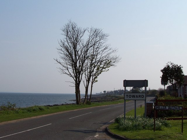
1066:== {{int:filedesc}} == {{Information |description={{en|1=Toward Toward. The A815 heading towards the village of Toward. The Toward lighthouses (one disused) can be seen in the distance in the centre of the picture.}} |date=2006-05-08 |source=From [http://
401:– You must give appropriate credit, provide a link to the license, and indicate if changes were made. You may do so in any reasonable manner, but not in any way that suggests the licensor endorses you or your use.
273:
223:
729:
713:
631:
587:
900:
721:
496:
944:
940:
896:
832:
828:
725:
709:
583:
492:
488:
480:
737:
733:
717:
671:
627:
484:
476:
78:
46:
121:
Toward Toward. The A815 heading towards the village of Toward. The Toward lighthouses (one disused) can be seen in the distance in the centre of the picture.
1059:
634:"}},"text\/plain":{"en":{"P275":"Creative Commons Attribution-ShareAlike 2.0 Generic"}}}}": -->
740:"}},"text\/plain":{"en":{"P973":"https:\/\/www.geograph.org.uk\/photo\/166516"}}}}": -->
763:
657:
613:
283:
233:
926:
783:
318:
1091:
This file contains additional information, probably added from the digital camera or scanner used to create or digitize it.
408:
568:
985:
958:
910:
873:
846:
791:
747:
597:
561:
548:
533:
806:
776:
681:
641:
506:
465:
1210:
1113:
1048:
1043:
903:"}},"text\/plain":{"en":{"P4082":"Kodak EasyShare Z700"}}}}": -->
364:
37:
1094:
If the file has been modified from its original state, some details may not fully reflect the modified file.
407:– If you remix, transform, or build upon the material, you must distribute your contributions under the
325:
on the
Geograph website for the photographer's contact details. The copyright on this image is owned by
499:"}},"text\/plain":{"en":{"P3831":"photographer"}}}}": -->
590:"}},"text\/plain":{"en":{"P6216":"copyrighted"}}}}": -->
951:"}},"text\/plain":{"en":{"P7787":"202 degree"}}}}": -->
839:"}},"text\/plain":{"en":{"P7787":"202 degree"}}}}": -->
86:
178:
1247:
1103:
813:
798:
540:
361:
162:
8:
1283:
305:
289:
239:
1372:
330:
73:
455:
1335:
1265:
1229:
1120:
1382:
1345:
1160:
151:
141:
1293:
968:
920:
856:
757:
691:
651:
607:
516:
310:
1140:
322:
1392:
1130:
1016:
Click on a date/time to view the file as it appeared at that time.
275:
225:
1080:
260:
55° 52′ 43″ N, 4° 58′ 29″ W
210:
55° 52′ 43″ N, 4° 58′ 29″ W
130:
61:
449:
Add a one-line explanation of what this file represents
1074:
1014:
85:
Commons is a freely licensed media file repository.
658:
Creative
Commons Attribution-ShareAlike 2.0 Generic
632:
Creative
Commons Attribution-ShareAlike 2.0 Generic
1288:Flash did not fire, compulsory flash suppression
51:(640 × 480 pixels, file size: 61 KB, MIME type:
418:https://creativecommons.org/licenses/by-sa/2.0
66:
424:Creative Commons Attribution-Share Alike 2.0
342:
126:
108:
738:https:\/\/www.geograph.org.uk\/photo\/166516
485:https:\/\/www.geograph.org.uk\/profile\/4827
147:
136:
111:Toward Toward - geograph.org.uk - 166516.jpg
47:Toward_Toward_-_geograph.org.uk_-_166516.jpg
14:
948:
836:
384:– to copy, distribute and transmit the work
814:https://www.geograph.org.uk/photo/166516
541:https://www.geograph.org.uk/profile/4827
282:View this and other nearby images on:
232:View this and other nearby images on:
185:
97:
329:and is licensed for reuse under the
250:
200:
1076:The following page uses this file:
1007:
365:Attribution-Share Alike 2.0 Generic
353:
348:
333:Attribution-ShareAlike 2.0 license.
13:
1089:
454:
448:
339:
316:
115:
98:
44:
1417:
1096:
453:
1151:Date and time of data generation
847:coordinates of the point of view
829:coordinates of the point of view
439:
395:Under the following conditions:
360:This file is licensed under the
352:
347:
341:
309:
288:
274:
266:
238:
224:
216:
65:
21:
436:
116:
41:No higher resolution available.
1114:KODAK Z700 ZOOM DIGITAL CAMERA
1011:
764:file available on the internet
714:file available on the internet
435:
317:This image was taken from the
26:
1:
959:coordinates of depicted place
941:coordinates of depicted place
31:
1071:
784:Geograph Britain and Ireland
722:Geograph Britain and Ireland
562:object of statement has role
493:object of statement has role
461:Items portrayed in this file
301:
265:
215:
7:
1221:Date and time of digitizing
1086:
974:55°52'42.78"N, 4°58'28.92"W
862:55°52'43.43"N, 4°58'28.56"W
10:
1422:
1356:Focal length in 35 mm film
1314:One-chip color area sensor
409:same or compatible license
191:Thomas Nugent /
172:Thomas Nugent /
105:
100:
1008:
16:
792:geograph.org.uk image ID
726:geograph.org.uk image ID
438:
375:
72:This is a file from the
36:
1319:Custom image processing
1065:
163:required by the license
129:
76:. Information from its
1402:Subject distance range
1044:12:57, 31 January 2010
323:this photograph's page
294:55.878550; -4.974700
244:55.878730; -4.974600
79:description page there
1257:Maximum land aperture
1178:Horizontal resolution
1104:EASTMAN KODAK COMPANY
927:Kodak EasyShare Z700
901:Kodak EasyShare Z700
1194:Y and C positioning
1186:Vertical resolution
1100:Camera manufacturer
390:– to adapt the work
1364:Scene capture type
1340:Auto white balance
549:author name string
489:author name string
1409:
1408:
1260:3.5 APEX (f/3.36)
1224:16:44, 8 May 2006
1154:16:44, 8 May 2006
1125:1/500 sec (0.002)
1069:
950:
838:
642:copyright license
628:copyright license
447:
338:
337:
321:collection. See
299:
298:
249:
248:
198:
197:
166:
94:
93:
74:Wikimedia Commons
1413:
1202:Exposure Program
1097:
1056:
1018:
996:
995:
990:
884:
883:
878:
816:
811:
807:described at URL
801:
796:
786:
781:
734:described at URL
598:copyright status
584:copyright status
571:
566:
556:
553:
543:
538:
445:
431:
428:
425:
422:
419:
411:as the original.
373:
362:Creative Commons
356:
355:
351:
350:
345:
344:
331:Creative Commons
319:Geograph project
313:
306:
295:
292:
278:
277:
271:
270:
269:
263:
262:
251:
245:
242:
228:
227:
221:
220:
219:
213:
212:
201:
160:
132:
120:
112:
106:
90:
69:
68:
62:
56:
54:
1421:
1420:
1416:
1415:
1414:
1412:
1411:
1410:
1085:
1070:
1062:
1054:
1010:
1009:
1006:
1005:
1004:
1003:
1002:
1001:
1000:
999:
998:
997:
993:
991:
988:
979:
978:
977:
975:
965:
964:
963:
961:
938:
937:
936:
935:
934:
933:
932:
931:
929:
917:
916:
915:
913:
894:
893:
892:
891:
890:
889:
888:
887:
886:
885:
881:
879:
876:
867:
866:
865:
863:
853:
852:
851:
849:
826:
825:
824:
823:
822:
821:
820:
819:
818:
817:
812:
809:
803:
802:
797:
794:
788:
787:
782:
779:
770:
769:
768:
766:
754:
753:
752:
750:
707:
706:
705:
704:
703:
702:
701:
700:
698:
688:
687:
686:
684:
669:
668:
667:
666:
665:
664:
663:
662:
660:
648:
647:
646:
644:
625:
624:
623:
622:
621:
620:
619:
618:
616:
604:
603:
602:
600:
581:
580:
579:
578:
577:
576:
575:
574:
573:
572:
567:
564:
558:
557:
554:
551:
545:
544:
539:
536:
527:
526:
525:
523:
513:
512:
511:
509:
474:
473:
472:
471:
470:
468:
452:
451:
450:
433:
432:
429:
426:
423:
420:
417:
416:
374:
371:
368:
357:
334:
304:
293:
267:
258:
257:
254:Object location
243:
217:
208:
207:
204:Camera location
199:
188:
181:
169:
142:geograph.org.uk
122:
110:
103:
96:
95:
84:
83:
82:is shown below.
58:
52:
50:
43:
42:
12:
11:
5:
1419:
1407:
1406:
1403:
1399:
1398:
1395:
1389:
1388:
1385:
1379:
1378:
1375:
1369:
1368:
1365:
1361:
1360:
1357:
1353:
1352:
1349:
1342:
1341:
1338:
1332:
1331:
1328:
1324:
1323:
1322:Normal process
1320:
1316:
1315:
1312:
1311:Sensing method
1308:
1307:
1304:
1303:Exposure index
1300:
1299:
1296:
1290:
1289:
1286:
1280:
1279:
1276:
1272:
1271:
1268:
1262:
1261:
1258:
1254:
1253:
1250:
1244:
1243:
1240:
1236:
1235:
1232:
1226:
1225:
1222:
1218:
1217:
1214:
1207:
1206:
1205:Normal program
1203:
1199:
1198:
1195:
1191:
1190:
1187:
1183:
1182:
1179:
1175:
1174:
1171:
1167:
1166:
1163:
1156:
1155:
1152:
1148:
1147:
1144:
1137:
1136:
1133:
1127:
1126:
1123:
1117:
1116:
1111:
1107:
1106:
1101:
1088:
1084:
1083:
1073:
1068:
1067:
1064:
1060:
1057:
1051:
1046:
1041:
1037:
1036:
1033:
1030:
1027:
1024:
1021:
1013:
984:
983:
982:
981:
980:
976:
973:
971:
970:
969:
967:
966:
962:
957:
955:
954:
953:
952:
946:
942:
930:
925:
923:
922:
921:
919:
918:
914:
909:
907:
906:
905:
904:
902:
898:
872:
871:
870:
869:
868:
864:
861:
859:
858:
857:
855:
854:
850:
845:
843:
842:
841:
840:
834:
830:
805:
804:
790:
789:
775:
774:
773:
772:
771:
767:
762:
760:
759:
758:
756:
755:
751:
748:source of file
746:
744:
743:
742:
741:
739:
735:
731:
727:
723:
719:
715:
711:
710:source of file
699:
696:
694:
693:
692:
690:
689:
685:
680:
678:
677:
676:
675:
673:
661:
656:
654:
653:
652:
650:
649:
645:
640:
638:
637:
636:
635:
633:
629:
617:
612:
610:
609:
608:
606:
605:
601:
596:
594:
593:
592:
591:
589:
585:
560:
559:
547:
546:
532:
531:
530:
529:
528:
524:
521:
519:
518:
517:
515:
514:
510:
505:
503:
502:
501:
500:
498:
494:
490:
486:
482:
478:
469:
464:
462:
459:
458:
457:
456:
444:
443:
440:
437:
415:
414:
413:
412:
402:
393:
392:
391:
385:
378:You are free:
369:
359:
358:
340:
336:
335:
314:
303:
300:
297:
296:
286:
280:
255:
247:
246:
236:
230:
205:
196:
195:
189:
186:
183:
182:
177:
170:
167:
155:
154:
149:
145:
144:
138:
134:
133:
128:
124:
123:
113:
104:
102:
99:
92:
91:
70:
60:
59:
40:
35:
34:
29:
24:
19:
9:
6:
4:
3:
2:
1418:
1404:
1401:
1400:
1396:
1394:
1391:
1390:
1386:
1384:
1381:
1380:
1376:
1374:
1371:
1370:
1366:
1363:
1362:
1358:
1355:
1354:
1350:
1347:
1344:
1343:
1339:
1337:
1336:White balance
1334:
1333:
1330:Auto exposure
1329:
1327:Exposure mode
1326:
1325:
1321:
1318:
1317:
1313:
1310:
1309:
1305:
1302:
1301:
1297:
1295:
1292:
1291:
1287:
1285:
1282:
1281:
1277:
1274:
1273:
1269:
1267:
1266:Metering mode
1264:
1263:
1259:
1256:
1255:
1251:
1249:
1248:Exposure bias
1246:
1245:
1241:
1239:APEX aperture
1238:
1237:
1233:
1231:
1230:Shutter speed
1228:
1227:
1223:
1220:
1219:
1215:
1212:
1209:
1208:
1204:
1201:
1200:
1196:
1193:
1192:
1188:
1185:
1184:
1180:
1177:
1176:
1172:
1169:
1168:
1164:
1162:
1158:
1157:
1153:
1150:
1149:
1145:
1142:
1139:
1138:
1134:
1132:
1129:
1128:
1124:
1122:
1121:Exposure time
1119:
1118:
1115:
1112:
1109:
1108:
1105:
1102:
1099:
1098:
1095:
1092:
1082:
1079:
1078:
1077:
1063:
1058:
1052:
1050:
1047:
1045:
1042:
1039:
1038:
1034:
1031:
1028:
1025:
1022:
1020:
1019:
1017:
987:
972:
960:
956:
928:
924:
912:
911:captured with
908:
897:captured with
875:
860:
848:
844:
815:
808:
800:
793:
785:
778:
765:
761:
749:
745:
695:
683:
679:
659:
655:
643:
639:
615:
611:
599:
595:
570:
563:
555:Thomas Nugent
550:
542:
535:
520:
508:
504:
467:
463:
460:
441:
434:
421:CC BY-SA 2.0
410:
406:
403:
400:
397:
396:
394:
389:
386:
383:
380:
379:
377:
376:
372:Thomas Nugent
370:Attribution:
366:
363:
346:
332:
328:
327:Thomas Nugent
324:
320:
315:
312:
308:
307:
291:
287:
285:
284:OpenStreetMap
281:
279:
261:
256:
253:
252:
241:
237:
235:
234:OpenStreetMap
231:
229:
211:
206:
203:
202:
194:
193:Toward Toward
190:
184:
180:
176: /
175:
174:Toward Toward
171:
164:
159:
157:
156:
153:
152:Thomas Nugent
150:
146:
143:
139:
135:
125:
119:
114:
107:
88:
81:
80:
75:
71:
64:
63:
57:
48:
39:
33:
30:
28:
25:
23:
20:
18:
15:
1346:Digital zoom
1275:Light source
1161:focal length
1110:Camera model
1093:
1090:
1075:
1015:
1012:File history
569:photographer
497:photographer
404:
398:
387:
381:
326:
264:
214:
192:
179:CC BY-SA 2.0
173:
117:
87:You can help
77:
45:
22:File history
1294:Color space
1170:Orientation
1061:GeographBot
614:copyrighted
588:copyrighted
405:share alike
399:attribution
158:Attribution
109:Description
1383:Saturation
1072:File usage
1053:640 × 480
1029:Dimensions
697:8 May 2006
522:some value
131:8 May 2006
53:image/jpeg
27:File usage
1393:Sharpness
1367:Landscape
1141:ISO speed
1026:Thumbnail
1023:Date/Time
682:inception
672:inception
302:Licensing
187:InfoField
168:InfoField
118:English:
1373:Contrast
1197:Centered
1131:F-number
1087:Metadata
777:operator
718:operator
442:Captions
388:to remix
382:to share
367:license.
32:Metadata
1405:Unknown
1278:Unknown
1270:Pattern
1213:version
1189:230 dpi
1181:230 dpi
1055:(61 KB)
1040:current
1035:Comment
986:heading
945:heading
874:heading
833:heading
507:creator
477:creator
466:depicts
446:English
101:Summary
49:
1397:Normal
1387:Normal
1377:Normal
1173:Normal
1165:8.6 mm
1143:rating
1081:Toward
994:degree
949:degree
882:degree
837:degree
799:166516
730:166516
272:
222:
148:Author
137:Source
1359:50 mm
1348:ratio
1284:Flash
1159:Lens
1135:f/6.7
140:From
1298:sRGB
1216:2.21
1211:Exif
1032:User
992:202
880:202
430:true
427:true
127:Date
17:File
1242:5.5
534:URL
481:URL
1306:80
1146:80
989::
877::
810::
795::
780::
565::
552::
537::
1351:0
1252:0
1234:9
165:)
161:(
89:.
55:)
_region:GB-GBN_heading:202.00&language=en)
_region:GB-GBN_heading:202.00&language=en)
