43:
320:"}},"text\/plain":{"en":{"":"inception"}}},"{\"value\":{\"time\":\"+2014-10-13T00:00:00Z\",\"timezone\":0,\"before\":0,\"after\":0,\"precision\":11,\"calendarmodel\":\"http:\\\/\\\/www.wikidata.org\\\/entity\\\/Q1985727\"},\"type\":\"time\"}":{"text\/html":{"en":{"P571":"13 October 2014"}},"text\/plain":{"en":{"P571":"13 October 2014"}}}}": -->
258:
556:
223:
103:
551:
316:
796:
741:
243:
UN maps are, in principle, open source material and you can use them in your work or for making your own map. UN requests however that you delete the UN name, logo and reference number upon any modification to the map. Content of your map will be your responsibility. You can state in your
891:
926:
721:
493:
981:
73:
69:
503:
65:
61:
57:
53:
47:
726:
921:
886:
731:
736:
317:
114:
82:
546:
626:
518:
666:
434:
671:
406:
448:
420:
245:
954:
This file contains additional information, probably added from the digital camera or scanner used to create or digitize it.
681:
523:
327:
306:
244:
publication, if you wish, something like: based on UN map … (map name, map number, revision number and date). See:
513:
176:
395:
390:
42:
957:
If the file has been modified from its original state, some details may not fully reflect the modified file.
846:
786:
566:
941:
237:
Unless stated otherwise, UN maps are to be considered in the public domain. This applies worldwide.
122:
576:
8:
508:
462:
931:
751:
716:
528:
498:
488:
483:
591:
109:
831:
296:
230:
249:
257:
836:
177:
https://www.ochaopt.org/sites/default/files/westbank_a0_25_06_2020_final.pdf
816:
337:
606:
557:التوغلات الإسرائيلية في الضفة الغربية خلال الحرب الفلسطينية الإسرائيلية
240:
Some UN maps have special copyrights, as indicated on the map itself.
761:
682:
Incursions israéliennes en
Cisjordanie pendant la guerre Israël-Hamas
826:
866:
363:
Click on a date/time to view the file as it appeared at that time.
911:
856:
806:
656:
586:
901:
876:
691:
494:
Israeli incursions in the West Bank during the Israel–Hamas war
766:
646:
504:
Population statistics for
Israeli settlements in the West Bank
616:
847:
Amerika legaliseert Israëlische nederzettingen op
Westoever
601:
552:الإحصائيات السكانية للمستوطنات الإسرائيلية في الضفة الغربية
992:
776:
706:
166:
97:
636:
282:
Add a one-line explanation of what this file represents
87:(4,964 × 7,020 pixels, file size: 15.18 MB, MIME type:
701:
477:
742:שיחה:שימוש ישראלי באמצעי מעקב בסכסוך הישראלי-פלסטיני
537:
361:
121:
Commons is a freely licensed media file repository.
519:User:Carter McCrae/Israeli–Palestinian conflict
102:
162:
144:
250:Geospatial, location data for a better world
182:
172:
14:
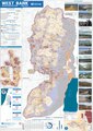
147:West Bank Access Restrictions June 2020.pdf
46:Size of this JPG preview of this PDF file:
539:The following other wikis use this file:
797:გაეროს უშიშროების საბჭოს რეზოლუცია 2334
892:Резолюция Совета Безопасности ООН 2334
479:The following 10 pages use this file:
222:
133:
217:
524:User:Falcaorib/Israel and Palestine
469:User created page with UploadWizard
354:
228:This image is a map derived from a
13:
952:
295:
289:
281:
256:
151:
134:
80:
1030:
959:
294:
157:West Bank access restrictions map
272:
221:
101:
31:
21:
982:Adobe InDesign 15.0 (Macintosh)
927:Резолюція Ради Безпеки ООН 2334
269:
152:
737:משתמש:Amit91803/אלימות מתנחלים
534:
514:Zionism as settler colonialism
358:
268:
246:Geospatial Information Section
26:
1:
832:Israëlische Westoeverbarrière
36:
837:Door Israël bezette gebieden
474:
413:Lossless file size reduction
302:Items portrayed in this file
193:
7:
949:
853:Usage on pcm.wikipedia.org
773:Usage on it.wikivoyage.org
633:Usage on en.wikivoyage.org
613:Usage on de.wikivoyage.org
607:Israelische Kontrollstation
573:Usage on azb.wikipedia.org
563:Usage on arz.wikipedia.org
10:
1035:
1010:2383.94 x 3370.39 pts (A0)
938:Usage on zh.wikipedia.org
918:Usage on uk.wikipedia.org
908:Usage on tl.wikipedia.org
898:Usage on sl.wikipedia.org
883:Usage on ru.wikipedia.org
873:Usage on pt.wikipedia.org
863:Usage on pl.wikipedia.org
823:Usage on nl.wikipedia.org
813:Usage on lt.wikipedia.org
803:Usage on ko.wikipedia.org
793:Usage on ka.wikipedia.org
783:Usage on ja.wikipedia.org
758:Usage on id.wikipedia.org
748:Usage on he.wikiquote.org
722:סיפוח יהודה ושומרון לישראל
713:Usage on he.wikipedia.org
698:Usage on ha.wikipedia.org
688:Usage on fy.wikipedia.org
678:Usage on fr.wikipedia.org
663:Usage on fa.wikipedia.org
653:Usage on eu.wikipedia.org
643:Usage on eo.wikipedia.org
623:Usage on el.wikipedia.org
598:Usage on de.wikipedia.org
583:Usage on cs.wikipedia.org
543:Usage on ar.wikipedia.org
141:
136:
843:Usage on nl.wikinews.org
355:
16:
762:Titik pemeriksaan Israel
271:
108:This is a file from the
41:
993:http://coherentpdf.com/
827:Westelijke Jordaanoever
727:משתמש:כותבערכים/התנחלות
547:منطقة ج (الضفة الغربية)
468:
440:
421:20:33, 14 December 2020
412:
186:United Nations OCHA oPt
165:
112:. Information from its
449:17:32, 27 January 2016
261:
115:description page there
1015:Version of PDF format
922:Ізраїльські поселення
887:Израильские поселения
732:קולוניאליזם התיישבותי
260:
912:Paninirahang Israeli
657:Palestinar enklabeak
592:Západní břeh Jordánu
74:4,964 × 7,020 pixels
70:1,448 × 2,048 pixels
902:Izraelske naselbine
877:Enclaves palestinos
857:Settler colonialism
627:Ισραηλινός οικισμός
509:Settler colonialism
52:Other resolutions:
988:Conversion program
529:User:Mr. Ibrahem/m
499:Israeli settlement
489:Israeli checkpoint
484:Area C (West Bank)
391:13:53, 20 May 2021
262:
66:724 × 1,024 pixels
1022:
1021:
867:Osiedla żydowskie
767:Permukiman Israel
672:استعمار مهاجرنشین
667:شهرکهای اسرائیلی
647:Israelaj setlejoj
535:Global file usage
472:
288:
280:
266:
265:
216:
215:
190:
189:
130:
129:
110:Wikimedia Commons
32:Global file usage
1026:
991:cpdfsqueeze 2.3
960:
459:
441:Updated for 2020
431:
403:
365:
286:
278:
225:
224:
218:
212:
209:
206:
203:
198:
197:
168:
167:7 September 2020
156:
148:
142:
126:
105:
104:
98:
92:
90:
77:
62:543 × 768 pixels
58:339 × 480 pixels
54:170 × 240 pixels
48:424 × 600 pixels
1034:
1033:
1029:
1028:
1027:
1025:
1024:
1023:
948:
817:Žydų nausėdijos
587:Izraelské osady
533:
473:
465:
457:
437:
429:
409:
401:
357:
356:
353:
352:
351:
350:
349:
348:
347:
346:
344:
343:13 October 2014
334:
333:
332:
330:
315:
314:
313:
312:
311:
309:
293:
292:
291:
284:
283:
210:
207:
204:
201:
196:
191:
158:
146:
139:
132:
131:
120:
119:
118:is shown below.
94:
89:application/pdf
88:
86:
79:
78:
51:
12:
11:
5:
1032:
1020:
1019:
1016:
1012:
1011:
1008:
1004:
1003:
1000:
996:
995:
989:
985:
984:
979:
975:
974:
972:
968:
967:
964:
951:
947:
946:
945:
944:
936:
935:
934:
929:
924:
916:
915:
914:
906:
905:
904:
896:
895:
894:
889:
881:
880:
879:
871:
870:
869:
861:
860:
859:
851:
850:
849:
841:
840:
839:
834:
829:
821:
820:
819:
811:
810:
809:
801:
800:
799:
791:
790:
789:
781:
780:
779:
771:
770:
769:
764:
756:
755:
754:
746:
745:
744:
739:
734:
729:
724:
719:
711:
710:
709:
704:
696:
695:
694:
692:Westjordaanlân
686:
685:
684:
676:
675:
674:
669:
661:
660:
659:
651:
650:
649:
641:
640:
639:
631:
630:
629:
621:
620:
619:
611:
610:
609:
604:
602:Westjordanland
596:
595:
594:
589:
581:
580:
579:
571:
570:
569:
561:
560:
559:
554:
549:
536:
532:
531:
526:
521:
516:
511:
506:
501:
496:
491:
486:
476:
471:
470:
467:
464:Triggerhippie4
463:
460:
454:
451:
446:
443:
442:
439:
435:
432:
426:
423:
418:
415:
414:
411:
407:
404:
400:4,964 × 7,020
398:
393:
388:
384:
383:
380:
377:
374:
371:
368:
360:
345:
342:
340:
339:
338:
336:
335:
331:
326:
324:
323:
322:
321:
319:
310:
305:
303:
300:
299:
298:
297:
290:Westjordanland
285:
277:
276:
273:
270:
264:
263:
254:
231:United Nations
226:
214:
213:
195:
192:
188:
187:
184:
180:
179:
174:
170:
169:
164:
160:
159:
149:
140:
138:
135:
128:
127:
106:
96:
95:
45:
40:
39:
34:
29:
24:
19:
9:
6:
4:
3:
2:
1031:
1017:
1014:
1013:
1009:
1006:
1005:
1001:
998:
997:
994:
990:
987:
986:
983:
980:
978:Software used
977:
976:
973:
970:
969:
966:Westbank_2010
965:
962:
961:
958:
955:
943:
940:
939:
937:
933:
930:
928:
925:
923:
920:
919:
917:
913:
910:
909:
907:
903:
900:
899:
897:
893:
890:
888:
885:
884:
882:
878:
875:
874:
872:
868:
865:
864:
862:
858:
855:
854:
852:
848:
845:
844:
842:
838:
835:
833:
830:
828:
825:
824:
822:
818:
815:
814:
812:
808:
805:
804:
802:
798:
795:
794:
792:
788:
785:
784:
782:
778:
775:
774:
772:
768:
765:
763:
760:
759:
757:
753:
750:
749:
747:
743:
740:
738:
735:
733:
730:
728:
725:
723:
720:
718:
715:
714:
712:
708:
705:
703:
700:
699:
697:
693:
690:
689:
687:
683:
680:
679:
677:
673:
670:
668:
665:
664:
662:
658:
655:
654:
652:
648:
645:
644:
642:
638:
635:
634:
632:
628:
625:
624:
622:
618:
615:
614:
612:
608:
605:
603:
600:
599:
597:
593:
590:
588:
585:
584:
582:
578:
575:
574:
572:
568:
565:
564:
562:
558:
555:
553:
550:
548:
545:
544:
542:
541:
540:
530:
527:
525:
522:
520:
517:
515:
512:
510:
507:
505:
502:
500:
497:
495:
492:
490:
487:
485:
482:
481:
480:
466:
461:
455:
452:
450:
447:
445:
444:
438:
433:
427:
424:
422:
419:
417:
416:
410:
405:
399:
397:
394:
392:
389:
386:
385:
381:
378:
375:
372:
369:
367:
366:
364:
341:
329:
325:
308:
304:
301:
274:
267:
259:
255:
253:
251:
247:
241:
239:
238:
233:
232:
227:
220:
219:
205:Public domain
202:Public domain
200:
199:
185:
181:
178:
175:
171:
161:
155:
150:
143:
124:
117:
116:
111:
107:
100:
99:
93:
84:
83:Original file
75:
71:
67:
63:
59:
55:
49:
44:
38:
35:
33:
30:
28:
25:
23:
20:
18:
15:
956:
953:
932:2012 у праві
777:Cisgiordania
707:Yosef Harish
538:
478:
453:No thumbnail
425:No thumbnail
362:
359:File history
242:
236:
235:
229:
153:
123:You can help
113:
81:
22:File history
963:Short title
145:Description
567:المستوطنات
475:File usage
458:(17.08 MB)
430:(15.92 MB)
402:(15.18 MB)
376:Dimensions
27:File usage
1007:Page size
999:Encrypted
702:Bar Hefer
637:West Bank
617:Palästina
373:Thumbnail
370:Date/Time
328:inception
318:inception
194:Licensing
154:English:
950:Metadata
577:ايسراییل
275:Captions
37:Metadata
787:ユダヤ人入植地
752:התנחלות
717:התנחלות
436:Veggies
387:current
382:Comment
307:depicts
279:English
248:. And:
137:Summary
85:
971:Author
942:以色列定居点
456:0 × 0
428:0 × 0
408:Jul059
287:German
183:Author
173:Source
234:map.
211:false
208:false
807:구획 C
379:User
163:Date
17:File
1018:1.6
1002:no
252:.
72:|
68:|
64:|
60:|
56:|
50:.
125:.
91:)
76:.

