314:
214:
871:
40:
876:
459:
With the construction of a new terminal building in 2015, public officials hoped to secure additional investment in the facility to attract passenger airlines. The new terminal building also allows for international flights to the airport, as it was constructed to accommodate a
389:
In
December 2013, Griffiss International Airport was selected as a test site by the United States Federal Aviation Administration to "aid in researching the complexities of integrating Unmanned Aircraft Systems into the congested, northeast airspace." Students from the
937:
957:
159:
720:
952:
947:
962:
913:
689:
942:
654:
932:
677:
906:
776:
694:
569:
391:
843:
461:
793:
443:
For the 12-month period ending July 31, 2023 the airport had 32,880 aircraft operations; average 90 per day: 85%
341:
304:
82:
44:
583:
899:
827:
647:
473:
152:
367:, United States. This airport is publicly owned by County of Oneida. It is located on the former site of
887:
85:
356:
743:
503:
499:
213:
595:
771:
738:
733:
728:
710:
640:
368:
364:
116:
20:
142:
386:, were transferred here in 2006, after which the county closed that airport in January 2007.
379:
428:
Griffiss
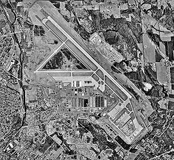
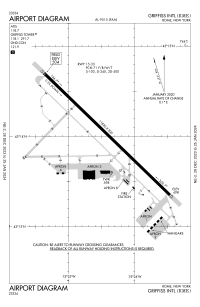
International Airport covers an area of 1,680 acres (680 ha) and contains one
811:
8:
540:
344:
397:
Griffiss is also a maintenance/storage facility for several regional airlines including
611:
383:
313:
806:
800:
682:
333:
325:
71:
60:
444:
398:
372:
615:
601:
518:
883:
663:
417:
413:
409:
360:
134:
926:
174:
161:
621:
605:
761:
766:
48:
240:
39:
589:
402:
625:
870:
448:
437:
270:
938:
Transportation buildings and structures in Oneida County, New York
875:
632:
352:
429:
227:
464:-regulation facility for potential international passengers.
436:
Runway 15/33: 11,820 x 200 ft (3,603 x 61 m), Surface:
195:
394:
will work with
Griffiss to test drones at the airport.
519:"FAA Selects Six Sites for Unmanned Aircraft Research"
371:, which closed in 1995. In 1999, the airfield hosted
19:For the former military use of this facility, see
924:
882:This article about an airport in New York is a
408:Several aircraft are stored here including: 2
958:New York (state) building and structure stubs
907:
648:
541:"New Griffiss terminal beacon for business?"
355:located one mile (1.6 km) east of the
290:Aircraft operations (year ending 7/31/2023)
914:
900:
655:
641:
953:Northeastern United States airport stubs
948:1990s establishments in New York (state)
312:
539:Cooper, Elizabeth (February 26, 2015).
925:
538:
963:New York (state) transportation stubs
636:
495:
493:
491:
489:
865:
570:"New York State DOT Airport Diagram"
516:
13:
777:List of people from Rome, New York
695:New York State School for the Deaf
662:
486:
14:
974:
562:
392:Rochester Institute of Technology
943:Transportation in Rome, New York
874:
869:
212:
38:
16:Public airport in Rome, New York
610:NOAA/NWS weather observations:
305:Federal Aviation Administration
716:Griffiss International Airport
532:
510:
322:Griffiss International Airport
32:Griffiss International Airport
1:
500:FAA Airport Form 5010 for RME
479:
423:
317:View of airport control tower
933:Airports in New York (state)
886:. You can help Knowledge by
828:Mohawk Correctional Facility
590:airport information for KRME
579:Resources for this airport:
474:List of airports in New York
7:
584:airport information for RME
467:
10:
979:
864:
690:Vernon-Verona-Sherrill CSD
18:
852:
836:
820:
785:
754:
703:
670:
517:FAA (December 30, 2013).
454:
451:, and <1% commercial.
357:central business district
301:
289:
285:
280:
247:
244:
239:
235:
226:
222:
211:
206:
190:
151:
140:
130:
122:
112:
104:
99:
55:
37:
30:
854:This list is incomplete.
596:accident history for RME
147:504 ft / 154 m
772:Griffiss Air Force Base
711:Rome station (New York)
545:Utica Observer-Dispatch
369:Griffiss Air Force Base
365:Oneida County, New York
21:Griffiss Air Force Base
812:List of radio stations
725:New York State Routes
507:, Effective 7/11/2024.
318:
821:Government facilities
380:Oneida County Airport
316:
175:43.23389°N 75.40694°W
405:, and several more.
378:Operations from the
807:List of TV stations
626:Terminal Procedures
606:live flight tracker
602:airport information
447:, 12% military, 3%
218:FAA airport diagram
180:43.23389; -75.40694
171: /
622:aeronautical chart
462:US Customs Service
384:Oriskany, New York
319:
895:
894:
859:
858:
801:Observer-Dispatch
683:Rome Free Academy
506:
311:
310:
297:
296:
281:Statistics (2023)
276:
275:
970:
916:
909:
902:
878:
873:
866:
657:
650:
643:
634:
633:
576:
574:
556:
555:
553:
551:
536:
530:
529:
527:
525:
514:
508:
502:
497:
445:general aviation
399:Republic Airways
287:
286:
237:
236:
230:
216:
202:
199:
197:
186:
185:
183:
182:
181:
176:
172:
169:
168:
167:
164:
92:
91:
78:
77:
67:
66:
42:
28:
27:
978:
977:
973:
972:
971:
969:
968:
967:
923:
922:
921:
920:
862:
860:
855:
848:
844:Capitol Theatre
832:
816:
781:
750:
699:
666:
661:
616:past three days
572:
568:
565:
560:
559:
549:
547:
537:
533:
523:
521:
515:
511:
498:
487:
482:
470:
457:
426:
410:Boeing 747-200s
307:
228:
217:
194:
179:
177:
173:
170:
165:
162:
160:
158:
157:
141:Elevation
95:
89:
81:
75:
70:
64:
59:
51:
33:
24:
17:
12:
11:
5:
976:
966:
965:
960:
955:
950:
945:
940:
935:
919:
918:
911:
904:
896:
893:
892:
879:
857:
856:
853:
850:
849:
847:
846:
840:
838:
834:
833:
831:
830:
824:
822:
818:
817:
815:
814:
809:
804:
797:
794:Daily Sentinel
789:
787:
783:
782:
780:
779:
774:
769:
764:
758:
756:
752:
751:
749:
748:
747:
746:
741:
736:
731:
723:
718:
713:
707:
705:
704:Transportation
701:
700:
698:
697:
692:
687:
686:
685:
674:
672:
668:
667:
664:Rome, New York
660:
659:
652:
645:
637:
631:
630:
629:
628:
618:
608:
598:
592:
586:
577:
564:
563:External links
561:
558:
557:
531:
509:
484:
483:
481:
478:
477:
476:
469:
466:
456:
453:
441:
440:
425:
422:
418:Boeing 777-200
414:Boeing 767-200
403:Envoy Airlines
351:) is a public
309:
308:
302:
299:
298:
295:
294:
291:
283:
282:
278:
277:
274:
273:
268:
265:
262:
258:
257:
254:
250:
249:
246:
243:
233:
232:
224:
223:
220:
219:
209:
208:
204:
203:
192:
188:
187:
155:
149:
148:
145:
138:
137:
135:Rome, New York
132:
128:
127:
124:
120:
119:
114:
110:
109:
106:
102:
101:
97:
96:
94:
93:
79:
68:
56:
53:
52:
43:
35:
34:
31:
15:
9:
6:
4:
3:
2:
975:
964:
961:
959:
956:
954:
951:
949:
946:
944:
941:
939:
936:
934:
931:
930:
928:
917:
912:
910:
905:
903:
898:
897:
891:
889:
885:
880:
877:
872:
868:
867:
863:
851:
845:
842:
841:
839:
835:
829:
826:
825:
823:
819:
813:
810:
808:
805:
803:
802:
798:
796:
795:
791:
790:
788:
784:
778:
775:
773:
770:
768:
765:
763:
760:
759:
757:
753:
745:
742:
740:
737:
735:
732:
730:
727:
726:
724:
722:
719:
717:
714:
712:
709:
708:
706:
702:
696:
693:
691:
688:
684:
681:
680:
679:
676:
675:
673:
669:
665:
658:
653:
651:
646:
644:
639:
638:
635:
627:
623:
619:
617:
613:
609:
607:
603:
599:
597:
593:
591:
587:
585:
581:
580:
578:
571:
567:
566:
546:
542:
535:
520:
513:
505:
501:
496:
494:
492:
490:
485:
475:
472:
471:
465:
463:
452:
450:
446:
439:
435:
434:
433:
431:
421:
419:
415:
411:
406:
404:
400:
395:
393:
387:
385:
381:
376:
374:
373:Woodstock '99
370:
366:
362:
358:
354:
350:
346:
343:
339:
335:
331:
327:
323:
315:
306:
300:
292:
288:
284:
279:
272:
269:
266:
263:
260:
259:
255:
252:
251:
242:
238:
234:
231:
225:
221:
215:
210:
205:
201:
193:
189:
184:
156:
154:
150:
146:
144:
139:
136:
133:
129:
126:Oneida County
125:
121:
118:
117:Oneida County
115:
111:
107:
103:
98:
87:
84:
80:
73:
69:
62:
58:
57:
54:
50:
46:
41:
36:
29:
26:
22:
888:expanding it
881:
861:
799:
792:
762:Fort Stanwix
715:
678:Rome City SD
600:FlightAware
550:February 26,
548:. Retrieved
544:
534:
524:December 30,
522:. Retrieved
512:
458:
442:
427:
407:
396:
388:
377:
363:, a city in
348:
337:
329:
321:
320:
105:Airport type
25:
178: /
166:075°24′25″W
153:Coordinates
927:Categories
767:Erie Canal
620:SkyVector
480:References
424:Facilities
163:43°14′02″N
49:orthophoto
837:Landmarks
671:Education
241:Direction
468:See also
449:air taxi
438:Concrete
416:, and 1
303:Source:
271:Concrete
248:Surface
200:/airport
131:Location
755:History
612:current
588:AirNav
353:airport
264:11,820
245:Length
229:Runways
191:Website
100:Summary
721:CENTRO
455:Future
430:runway
293:32,880
267:3,603
261:15/33
123:Serves
108:Public
786:Media
573:(PDF)
196:ocgov
113:Owner
47:1997
884:stub
604:and
594:ASN
582:FAA
552:2015
526:2013
412:, 1
361:Rome
338:KRME
334:ICAO
326:IATA
207:Maps
198:.net
143:AMSL
76:KRME
72:ICAO
61:IATA
45:USGS
744:265
504:PDF
382:in
359:of
349:RME
345:LID
342:FAA
330:RME
253:ft
90:RME
86:LID
83:FAA
65:RME
929::
739:69
734:49
729:26
624:,
614:,
543:.
488:^
432::
420:.
401:,
375:.
347::
340:,
336::
332:,
328::
256:m
88::
74::
63::
915:e
908:t
901:v
890:.
656:e
649:t
642:v
575:.
554:.
528:.
324:(
23:.
Text is available under the Creative Commons Attribution-ShareAlike License. Additional terms may apply.


