270:
258:
33:
257:
354:
40:
269:
230:
In the late 1970s, prior to the flooding of the lake, several archaeological sites in the flood plain were excavated. Excavations were led by various international organisations, such as the
British Archaeological Expedition, as well as the Iraqi State Organisation for Antiquities and Heritage. Sites
328:
R. G. Killick, "Excavations at Tell
Rubeidheh: An Uruk Village in the Jebel Hamrin", Iraq Archaeological Reports, 2, British School of Archaeology in Iraq and Directorate of Antiquities, Baghdad; Hamrin Salvage Report, no. 7, Warminster: Aris & Phillips,
210:, which creates Lake Hamrin, was established in 1981 as an artificial dam to hold over two billion cubic metres of water. It is a source of fish and also provides water for nearby
251:
and Tell
Haizalun. The Hamrin sites probably shared a localised form of the Ubaid culture and possibly operated as one administrative unit based out of Tell Abada.
263:
Polychrome painted jar, geometric designs and animals, the so-called "Scarlet Ware". From Tell Abu Qasim at Hamrin Basin. 2800-2600 BCE. Iraq Museum
338:
Jasim, S. 1985. "The Ubaid period in Iraq. Recent excavations in the Hamrin region." British
Archaeological Reports International Series: 267
75:
395:
275:
Painted pottery jar with geometric motifs and birds. From Tell Hasan at Hamrin Basin. 5th millennium BCE. Iraq Museum
32:
206:
sits on the western shore of the lake, both of which are at the southern tip of the Hamrin mountains. The
419:
414:
388:
424:
429:
107:
8:
434:
381:
199:
61:
369:
299:
365:
119:
408:
90:
77:
312:
244:
232:
219:
248:
240:
236:
207:
211:
112:
214:
orchards and other farms. In June 2008, it was reported that due to
195:
300:"The New Humanitarian | Disappearing lake a blow to livelihoods"
353:
203:
179:
319:. London: The British School of Archaeology in Iraq, pp 40–47
361:
215:
191:
125:
194:
approximately 50 km (31 mi) north-east of
406:
222:, the lake had lost nearly 80% of its capacity.
68:
315:1982. "The Hamrin Sites." In: J. Curtis (ed.)
280:
389:
225:
396:
382:
407:
317:Fifty Years of Mesopotamian Discovery
348:
39:
13:
14:
446:
139:340 km (130 sq mi)
352:
268:
256:
38:
31:
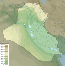
16:Reservoir in Diyala Governorate
332:
322:
306:
292:
1:
285:
368:. You can help Knowledge by
7:
281:Droughts and Climate Change
10:
451:
347:
226:Archaeological excavations
175:
171:
143:
135:
131:
118:
106:
67:
57:
26:
21:
364:-related article is a
231:excavated include the
91:34.19111°N 44.99500°E
87: /
420:Diyala Governorate
415:Reservoirs in Iraq
247:, Tell Rubeidheh,
200:Diyala Governorate
96:34.19111; 44.99500
62:Diyala Governorate
377:
376:
185:
184:
442:
398:
391:
384:
356:
349:
339:
336:
330:
326:
320:
310:
304:
303:
296:
272:
260:
190:, is a man-made
163:
162:
153:
152:
102:
101:
99:
98:
97:
92:
88:
85:
84:
83:
80:
70:
42:
41:
35:
19:
18:
450:
449:
445:
444:
443:
441:
440:
439:
405:
404:
403:
402:
345:
343:
342:
337:
333:
327:
323:
311:
307:
298:
297:
293:
288:
283:
276:
273:
264:
261:
228:
218:damming of the
160:
158:
150:
148:
122: countries
95:
93:
89:
86:
81:
78:
76:
74:
73:
53:
52:
51:
50:
49:
48:
47:
43:
17:
12:
11:
5:
448:
438:
437:
432:
427:
422:
417:
401:
400:
393:
386:
378:
375:
374:
357:
341:
340:
331:
321:
305:
290:
289:
287:
284:
282:
279:
278:
277:
274:
267:
265:
262:
255:
227:
224:
202:. The town of
183:
182:
177:
173:
172:
169:
168:
167: acre⋅ft)
145:
141:
140:
137:
133:
132:
129:
128:
123:
116:
115:
110:
104:
103:
71:
65:
64:
59:
55:
54:
45:
44:
37:
36:
30:
29:
28:
27:
24:
23:
15:
9:
6:
4:
3:
2:
447:
436:
433:
431:
428:
426:
425:Lakes of Iraq
423:
421:
418:
416:
413:
412:
410:
399:
394:
392:
387:
385:
380:
379:
373:
371:
367:
363:
358:
355:
351:
350:
346:
335:
325:
318:
314:
309:
301:
295:
291:
271:
266:
259:
254:
253:
252:
250:
246:
242:
238:
234:
223:
221:
217:
213:
209:
205:
201:
197:
193:
189:
181:
178:
174:
170:
166:
156:
146:
142:
138:
134:
130:
127:
124:
121:
117:
114:
111:
109:
105:
100:
72:
66:
63:
60:
56:
34:
25:
20:
430:Ubaid period
370:expanding it
359:
344:
334:
324:
316:
308:
294:
245:Tell Saadiya
233:Ubaid period
229:
220:Alwand River
198:, in Iraq's
187:
186:
164:
157: m (1.6
154:
144:Water volume
136:Surface area
249:Tell Rashid
241:Tell Madhur
188:Lake Hamrin
176:Settlements
94: /
69:Coordinates
46:Lake Hamrin
22:Lake Hamrin
435:Iraq stubs
409:Categories
286:References
237:Tell Abada
208:Hemrin Dam
82:44°59′42″E
79:34°11′28″N
235:sites of
212:date palm
113:reservoir
313:Roaf, M.
58:Location
216:Iranian
196:Baqubah
204:Hamrin
180:Hamrin
360:This
120:Basin
366:stub
362:Iraq
329:1988
192:lake
126:Iraq
108:Type
411::
243:,
239:,
161:10
151:10
397:e
390:t
383:v
372:.
302:.
165:^
159:×
155:^
149:×
147:2
Text is available under the Creative Commons Attribution-ShareAlike License. Additional terms may apply.


