130:
Island, Chief's Island, Kenesha Island, Strawberry Island, Bunny Island, Seven Pines Island, Eagle Island, Lilborne Island, Birch Island, Bottle Island, Chaplain Island, Loon Island, Little Loon Island, Fairy Island, Governors Island, Cameron Island, Little Chiefs Island, Home Island, Christmas Island, Elsinore Island, Harry Island, Lyford Island, Princess Island, Arma Island, Laurie Island, Sullivan Island, Caniff Island, Fawn Island, Baldy Island, Foster Island, Burgess Island, Sunshine Island, Ermananda Island, Leonard Island, Star Island, Black Forest Island, St. Helens Island, Bluff Island, Keith Island, Sunbeam Island, Coney Island, Sunset Island, Schooner Island, Anchor Island, Perch Island, Bass Island, Pickerel Island, Bell Island, Sugarloaf Island, Charity Island, Faith Island, Silver
Birches Island, Badgerow Island, Geoffrey Island, Reef Island, Crane Island, Helen Island
44:
26:
388:
445:
201:
168:
traditional territory of the
Anishinaabeg, which includes the Ojibwe, Odawa, and Potawatomi Nations, collectively known as the Three Fires Confederacy, as well as the Huron-Wendat and the Haudenosaunee Nations. Southern portions of Muskoka were the traditional territory of the Wendat between AD 1300 and 1650. The region is covered by the J. Collins land purchase of 1785, the Robinson-Huron Treaty of 1850 and the
51:
129:
Fraser Island, Blueberry Island, Island K, Emerald Island, Burnt Island, Round Island, Turtle Island, Dahmawah Island, Wegamind Island, Playfair Island, Gitchie Island, Waneshing Island, Bungay Island, Yoho Island, Birch Island, Rosebud Island, Peggy Island, Buck Island, Little Round Island, Cliff
175:
The Free Grants and
Homestead Act passed in 1868 was part of an attempt by the new Ontario provincial government to attract European immigration to create an agricultural society in Muskoka, however the prospects of agricultural development on the Canadian Shield were woefully overestimated.
167:
The
Muskoka region is located within the Canadian Shield and features bedrock exposures and a veneer of glacially- derived sandy substrate. The area was covered by proglacial Lake Algonquin (a precursor to Lake Huron) following glacial recession around 10,000 years ago. The region is the
179:
In the late nineteenth century road, rail and steamboat transportation infrastructure originally developed to support agriculture and forestry was repurposed to support tourism which became an important economic driver for Lake Joseph and the region.
159:. William Robinson, a member of the House of Assembly for Upper Canada (1830-1840) and later Commissioner of Public Works named Lake Joseph and neighbouring Lake Rosseau after his friend Joseph Rousseau, the father of a fur trader in the area.
147:. Cottage development in the Muskoka region began on the northern islands of Lake Joseph in the 1870's but quickly spread to other sections of all three of the larger Muskoka lakes. Lake Joseph is connected to
188:
There are many community groups based on Lake Joseph. The largest of these is the
Muskoka Lakes Association (MLA). The MLA was founded in 1894 to represent the interests of lakeshore residents on Lakes
197:
and many smaller surrounding lakes. The Lake Joseph North
Association was established in 1996 to represent shoreline residents at the north end of the lake, as well as those on Portage Lake.
304:
348:
514:
169:
305:
https://www.thecanadianencyclopedia.ca/en/article/john-collins-purchase#:~:text=John%20Collins%27%20Purchase%20of%201785,Georgian%20Bay%20in%20La
156:
43:
490:
429:
349:
https://uwspace.uwaterloo.ca/bitstream/handle/10012/6916/Shifflett_Geoffrey.pdf;jsessionid=DDD04497F5F46A987DF5A49C756BC5C0?sequence=1
76:
509:
363:
124:
519:
483:
422:
262:
MUSKOKA THE FIRST ISLANDERS AND AFTER by D. H. C. Mason 1974 : HERALD-GAZETTE PRESS BRACEBRIDGE, ONTARIO
524:
326:
476:
415:
271:
218:
152:
8:
464:
403:
315:
282:
205:
140:
460:
399:
337:
293:
25:
503:
91:
78:
194:
190:
148:
387:
444:
223:
327:
https://www.thecanadianencyclopedia.ca/en/article/williams-treaties
395:
144:
243:
200:
456:
452:
368:
373:
183:
501:
69:
236:
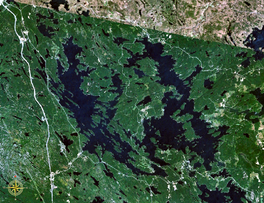
31:Lake Joseph to the west (left) of Lake Rosseau
515:Lakes of the District Municipality of Muskoka
484:
423:
50:
491:
477:
430:
416:
199:
502:
439:
382:
13:
184:Lake Front Resident Advocacy Group
14:
536:
357:
443:
386:
49:
42:
24:
342:
331:
320:
309:
298:
287:
276:
265:
256:
1:
510:Lakes of Parry Sound District
374:North Lake Joseph Association
229:
463:. You can help Knowledge by
402:. You can help Knowledge by
7:
212:
10:
541:
451:This article related to a
438:
381:
162:
369:Muskoka Lakes Association
364:Township of Muskoka Lakes
272:William Benjamin Robinson
123:
119:
111:
107:
68:
37:
23:
18:
219:List of lakes in Ontario
115:227 m (745 ft)
520:Ontario geography stubs
151:through the narrows at
398:location article is a
209:
203:
57:Lake Joseph (Ontario)
19:Lake Joseph (Ontario)
88: /
210:
525:Canada lake stubs
472:
471:
411:
410:
316:Robinson Treaties
170:Williams Treaties
134:
133:
112:Surface elevation
92:45.183°N 79.717°W
32:
532:
493:
486:
479:
447:
440:
432:
425:
418:
390:
383:
351:
346:
340:
335:
329:
324:
318:
313:
307:
302:
296:
291:
285:
280:
274:
269:
263:
260:
254:
253:
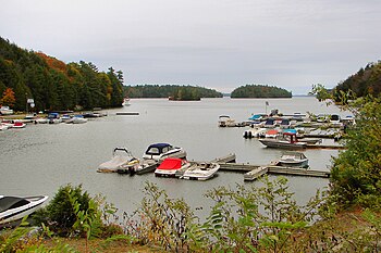
251:
250:
240:
103:
102:
100:
99:
98:
93:
89:
86:
85:
84:
81:
71:
53:
52:
46:
30:
28:
16:
15:
540:
539:
535:
534:
533:
531:
530:
529:
500:
499:
498:
497:
437:
436:
379:
360:
355:
354:
347:
343:
336:
332:
325:
321:
314:
310:
303:
299:
292:
288:
283:Canadian Shield
281:
277:
270:
266:
261:
257:
248:
246:
242:
241:
237:
232:
215:
186:
165:
141:Seguin Township
97:45.183; -79.717
96:
94:
90:
87:
82:
79:
77:
75:
74:
64:
63:
62:
61:
60:
59:
58:
54:
33:
12:
11:
5:
538:
528:
527:
522:
517:
512:
496:
495:
488:
481:
473:
470:
469:
448:
435:
434:
427:
420:
412:
409:
408:
391:
377:
376:
371:
366:
359:
358:External links
356:
353:
352:
341:
338:Homestead Acts
330:
319:
308:
297:
294:Lake Algonquin
286:
275:
264:
255:
244:"Google Earth"
234:
233:
231:
228:
227:
226:
221:
214:
211:
185:
182:
164:
161:
153:Port Sandfield
139:is located in
132:
131:
127:
121:
120:
117:
116:
113:
109:
108:
105:
104:
72:
66:
65:
56:
55:
48:
47:
41:
40:
39:
38:
35:
34:
29:
21:
20:
9:
6:
4:
3:
2:
537:
526:
523:
521:
518:
516:
513:
511:
508:
507:
505:
494:
489:
487:
482:
480:
475:
474:
468:
466:
462:
458:
454:
449:
446:
442:
441:
433:
428:
426:
421:
419:
414:
413:
407:
405:
401:
397:
392:
389:
385:
384:
380:
375:
372:
370:
367:
365:
362:
361:
350:
345:
339:
334:
328:
323:
317:
312:
306:
301:
295:
290:
284:
279:
273:
268:
259:
245:
239:
235:
225:
222:
220:
217:
216:
207:
202:
198:
196:
193:, Joseph and
192:
181:
177:
173:
171:
160:
158:
154:
150:
146:
142:
138:
128:
126:
122:
118:
114:
110:
106:
101:
73:
67:
45:
36:
27:
22:
17:
465:expanding it
450:
404:expanding it
393:
378:
344:
333:
322:
311:
300:
289:
278:
267:
258:
247:. Retrieved
238:
187:
178:
174:
166:
157:Joseph River
149:Lake Rosseau
136:
135:
137:Lake Joseph
95: /
70:Coordinates
504:Categories
249:2021-01-31
230:References
206:Gordon Bay
204:Marina at
224:Camp Ekon
172:of 1923.
213:See also
155:and the
396:Ontario
195:Muskoka
191:Rosseau
163:History
145:Ontario
125:Islands
83:79°43′W
80:45°11′N
457:Canada
459:is a
394:This
461:stub
453:lake
400:stub
455:in
506::
143:,
492:e
485:t
478:v
467:.
431:e
424:t
417:v
406:.
252:.
208:.
Text is available under the Creative Commons Attribution-ShareAlike License. Additional terms may apply.


