438:
88:
631:
59:
118:
446:
mountains). In the 1997 land survey, 33.52% of the total land area was forested. Of the agricultural land, 57.6% is used for farming or pastures, while 3.04% is used for orchards or vine crops. Of the settled areas, 2.42% is covered with buildings, 0.08% is industrial, 0.08% is classed as special developments, 0.23% is parks or greenbelts and 2.57% is transportation infrastructure. Of the unproductive areas, 0.16% is unproductive standing water (ponds or lakes), and 0.31% are unproductive flowing water (rivers).
619:
47:
125:
95:
527:
In the 2000 census the religious membership of
Neudorf was; 851 (80.4%) were Roman Catholic, and 103 (9.7%) were Protestant, with an additional 5 (0.47%) that were of some other Christian faith. There are 1 individuals (0.09% of the population) who are Jewish. There are 26 individuals (2.46% of the
503:
As of 2000 there are 348 households, of which 75 households (or about 21.6%) contain only a single individual. 66 or about 19.0% are large households, with at least five members. As of 2000 there were 247 inhabited buildings in the municipality, of which 188 were built only as housing, and 59 were
486:
The age distribution in
Neudorf is; 309 people or 27% of the population is 0–19 years old. 315 people or 27.6% are 20–39 years old, and 381 people or 33.3% are 40–64 years old. The senior population distribution is 112 people or 9.8% are 65–79 years old, 22 or 1.9% are 80–89 years old and 4 people
463:
Neudorf had a population (as of 2010) of 1,196. In 2007 at total of 7.7% of the population were foreign nationals. Over the last 10 years the population has grown at a rate of 5.9%. Most of the population (as of 2000) speaks German (94.9%), while
Albanian is second most common (2.1%) and Spanish
445:
Before the merger, Neudorf had a total area of 12.8 km (4.9 sq mi). Of this area, 60.6% is used for agricultural purposes, while 33.5% is forested. Of the rest of the land, 5.4% is settled (buildings or roads) and the remainder (0.5%) is non-productive (rivers, glaciers or
508:
buildings. There were 157 single family homes, 13 double family homes, and 18 multi-family homes in the municipality. Most homes were either two (131) or three (49) story structures. There were only 4 single story buildings and 4 four or more story buildings.
528:
population) who are Muslim. Of the rest; there were 2 (0.19%) individuals who belong to another religion, 49 (4.63%) who do not belong to any organized religion, 21 (1.98%) who did not answer the question.
524:, with 26 businesses in this sector. As of 2000 51.4% of the population of the municipality were employed in some capacity. At the same time, females made up 38.6% of the workforce.
800:
738:
472:
150:
296:
37:
653:
308:
783:
694:
468:
117:
87:
378:
204:
735:
630:
517:
521:
513:
491:
390:
58:
288:
480:
714:
182:
17:
490:
In
Neudorf about 72.3% of the population (between age 25-64) have completed either non-mandatory
476:
398:
192:
618:
512:
Neudorf has an unemployment rate of 1.44%. As of 2005, there were 112 people employed in the
505:
267:
277:
8:
258:
409:. On 1 January 2013 the former municipality of Neudorf merged into the municipality of
351:
197:
402:
742:
516:
and about 38 businesses involved in this sector. 143 people are employed in the
471:
which received 36.3% of the vote. The next three most popular parties were the
437:
496:
776:
770:
764:
687:
681:
675:
410:
331:
794:
165:
152:
520:
and there are 20 businesses in this sector. 129 people are employed in the
394:
343:
209:
339:
406:
284:
263:
46:
318:
450:
347:
335:
371:
531:
The historical population is given in the following table:
654:
362:
494:
or additional higher education (either university or a
467:
In the 2007 election the most popular party was the
792:
449:The former municipality is located in the upper
801:Former municipalities of the canton of Lucerne
487:or 0.3% of the population are 90+ years old.
23:Former municipality in Lucerne, Switzerland
777:
688:
771:
765:
682:
676:
16:For other places with the same name, see
731:
729:
727:
725:
723:
436:
647:
793:
710:
708:
706:
704:
720:
667:
665:
421:Neudorf is first mentioned in 924 as
784:Historical Dictionary of Switzerland
695:Historical Dictionary of Switzerland
224:12.83 km (4.95 sq mi)
701:
13:
736:LUSTAT Lucerne Cantonal Statistics
662:
14:
812:
754:
715:Swiss Federal Statistical Office
629:
617:
123:
116:
93:
86:
57:
45:
458:
124:
94:
1:
641:
137:Show map of Canton of Lucerne
432:
289:Central European Summer Time
7:
10:
817:
610:
416:
232:672 m (2,205 ft)
15:
717:accessed 12 February 2013
636:Pilgrimage church Gormund
492:upper secondary education
357:
327:
317:
307:
295:
274:
257:
249:
241:
236:
228:
220:
215:
203:
191:
181:
146:
80:
71:
53:
44:
35:
28:
659:accessed 9 February 2013
18:Neudorf (disambiguation)
748:accessed 12 August 2009
514:primary economic sector
107:Show map of Switzerland
442:
253:93/km (240/sq mi)
440:
276: • Summer (
268:Central European Time
250: • Density
393:in the district of
162: /
74:Location of Neudorf
38:Former municipality
741:2011-11-27 at the
443:
441:Aerial view (1964)
242: • Total
221: • Total
624:Church St. Agatha
608:
607:
464:is third (0.6%).
384:
383:
808:
779:
773:
767:
749:
747:
733:
718:
712:
699:
690:
684:
678:
669:
660:
658:
651:
633:
621:
534:
533:
518:secondary sector
479:(21.4%) and the
376:
369:
366:
364:
281:
177:
176:
174:
173:
172:
167:
166:47.183°N 8.217°E
163:
160:
159:
158:
155:
138:
127:
126:
120:
108:
97:
96:
90:
61:
49:
26:
25:
816:
815:
811:
810:
809:
807:
806:
805:
791:
790:
757:
752:
745:
743:Wayback Machine
734:
721:
713:
702:
670:
663:
656:
652:
648:
644:
637:
634:
625:
622:
613:
522:tertiary sector
461:
435:
419:
379:SFSO statistics
374:
370:
361:
303:
275:
170:
168:
164:
161:
156:
153:
151:
149:
148:
142:
141:
140:
139:
136:
135:
134:
133:
132:
128:
111:
110:
109:
106:
105:
104:
103:
102:
98:
76:
75:
67:
66:
65:
64:
40:
31:
24:
21:
12:
11:
5:
814:
804:
803:
789:
788:
781:in the online
756:
755:External links
753:
751:
750:
719:
700:
692:in the online
661:
645:
643:
640:
639:
638:
635:
628:
626:
623:
616:
612:
609:
606:
605:
602:
598:
597:
594:
590:
589:
586:
582:
581:
578:
574:
573:
570:
566:
565:
562:
558:
557:
554:
550:
549:
546:
542:
541:
538:
497:Fachhochschule
460:
457:
434:
431:
418:
415:
382:
381:
359:
355:
354:
329:
325:
324:
321:
315:
314:
311:
305:
304:
301:
299:
297:Postal code(s)
293:
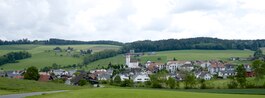
292:
282:
272:
271:
261:
255:
254:
251:
247:
246:
243:
239:
238:
234:
233:
230:
226:
225:
222:
218:
217:
213:
212:
207:
201:
200:
195:
189:
188:
185:
179:
178:
144:
143:
130:
129:
122:
121:
115:
114:
113:
112:
100:
99:
92:
91:
85:
84:
83:
82:
81:
78:
77:
73:
72:
69:
68:
62:
56:
55:
54:
51:
50:
42:
41:
36:
33:
32:
29:
22:
9:
6:
4:
3:
2:
813:
802:
799:
798:
796:
786:
785:
780:
774:
768:
762:
759:
758:
744:
740:
737:
732:
730:
728:
726:
724:
716:
711:
709:
707:
705:
697:
696:
691:
685:
679:
673:
668:
666:
655:
650:
646:
632:
627:
620:
615:
614:
603:
600:
599:
595:
592:
591:
587:
584:
583:
579:
576:
575:
571:
568:
567:
563:
560:
559:
555:
552:
551:
547:
544:
543:
539:
536:
535:
532:
529:
525:
523:
519:
515:
510:
507:
501:
499:
498:
493:
488:
484:
482:
478:
475:(30.8%), the
474:
470:
465:
456:
454:
453:
447:
439:
430:
428:
424:
414:
412:
408:
404:
400:
396:
392:
388:
380:
373:
368:
360:
356:
353:
349:
345:
341:
337:
333:
330:
328:Surrounded by
326:
322:
320:
319:ISO 3166 code
316:
312:
310:
306:
300:
298:
294:
290:
286:
283:
279:
273:
269:
265:
262:
260:
256:
252:
248:
244:
240:
235:
231:
227:
223:
219:
214:
211:
208:
206:
202:
199:
196:
194:
190:
186:
184:
180:
175:
171:47.183; 8.217
147:Coordinates:
145:
119:
89:
79:
70:
60:
52:
48:
43:
39:
34:
27:
19:
782:
760:
693:
671:
649:
530:
526:
511:
502:
495:
489:
485:
466:
462:
459:Demographics
451:
448:
444:
426:
422:
420:
391:municipality
389:is a former
386:
385:
344:Hildisrieden
63:Coat of arms
746:(in German)
657:(in German)
553:about 1695
540:population
481:Green Party
411:Beromünster
407:Switzerland
375:(in German)
332:Beromünster
309:SFOS number
187:Switzerland
169: /
642:References
556:up to 600
237:Population
506:mixed use
433:Geography
340:Römerswil
285:UTC+02:00
264:UTC+01:00
259:Time zone
229:Elevation
795:Category
739:Archived
483:(4.8%).
452:Wynental
423:Niwidorf
365:.neudorf
205:District
778:Italian
761:Neudorf
689:Italian
672:Neudorf
611:Gallery
548:c. 250
427:Niudorf
425:and as
417:History
403:Lucerne
397:in the
387:Neudorf
372:Profile
358:Website
348:Sempach
336:Gunzwil
198:Lucerne
183:Country
154:47°11′N
131:Neudorf
101:Neudorf
30:Neudorf
772:French
766:German
683:French
677:German
604:1,058
399:canton
395:Sursee
210:Sursee
193:Canton
157:8°13′E
601:2000
593:1950
585:1900
577:1850
569:1816
561:1798
545:1456
537:year
323:CH-LU
245:1,196
775:and
763:in
686:and
674:in
596:791
588:652
580:850
572:899
564:710
352:Eich
313:1092
302:6025
216:Area
500:).
477:SVP
473:CVP
469:FDP
405:in
401:of
367:.ch
363:www
278:DST
797::
769:,
722:^
703:^
680:,
664:^
455:.
429:.
413:.
377:,
350:,
346:,
342:,
338:,
334:,
787:.
698:.
291:)
287:(
280:)
270:)
266:(
20:.
Text is available under the Creative Commons Attribution-ShareAlike License. Additional terms may apply.