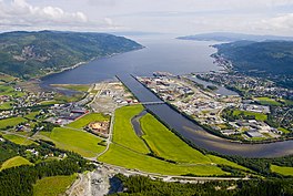
70:
368:
103:
45:
110:
77:
270:
Much of the land on either side of the fjord is quite steep and the gradient often continues into the sea with the fjord reaching depths in excess of 350 metres (1,150 ft) just a short distance from the shore in some places. The maximum depth of the
Trondheim Fjord is around 600 metres
258:
on the northwest side of the fjord. This is where the
Korsfjorden part of the Trondheim Fjord splits into two separate branches; Gaulosen that stretches towards the southeast and the Orkdal Fjord that stretches about 11 kilometres (6.8 mi) towards the southwest to
350:
409:
153:
69:
443:
402:
335:
305:
highway runs along the southeastern side of the fjord while county route 710 runs along the other side of the fjord.
102:
395:
267:
river at the end of the fjord. For most of its length the fjord is just over 2 kilometres (1.2 mi) wide.
17:
428:
185:
8:
325:
302:
383:
331:
433:
228:
438:
379:
422:
168:
155:
54:
367:
283:
375:
240:
138:
291:
264:
255:
279:
275:
260:
216:
50:
232:
295:
278:, lies at the end of the fjord. The harbour is administered by
251:
244:
254:
village on the southeast side of the fjord and the village of
44:
236:
190:
287:
330:. Stavanger: Norges sjøkartverk. 1992. pp. 233–236.
327:
Den Norske los. Bind 4: Farvannsbeskrivelse Statt-Rørvik
420:
146:
403:
410:
396:
14:
421:
274:Orkanger Harbour, which also includes
320:
318:
362:
109:
76:
24:
315:
25:
455:
366:
250:The Orkdal Fjord starts between
108:
101:
75:
68:
43:
344:
49:View of the Orkdal Fjord with
13:
1:
308:
382:. You can help Knowledge by
282:Harbour. The main export is
7:
204:11 kilometres (6.8 mi)
53:and the mouth of the river
10:
460:
361:
27:Fjord in Trøndelag, Norway
444:Trøndelag geography stubs
351:Kartverket - Location map
286:and the main imports are
212:
208:
200:
196:
184:
145:
134:
62:
42:
37:
32:
378:location article is a
263:and the mouth of the
122:Orkdal Fjord (Norway)
92:Show map of Trøndelag
89:Location of the fjord
169:63.3533°N 9.934463°E
227:is a branch of the
165: /
57:in the foregraound.
303:European route E39
239:municipalities in
125:Show map of Norway
391:
390:
271:(2,000 ft).
222:
221:
174:63.3533; 9.934463
16:(Redirected from
451:
412:
405:
398:
370:
363:
353:
348:
342:
341:
322:
180:
179:
177:
176:
175:
170:
166:
163:
162:
161:
158:
148:
126:
112:
111:
105:
93:
79:
78:
72:
47:
30:
29:
21:
459:
458:
454:
453:
452:
450:
449:
448:
429:Trondheimsfjord
419:
418:
417:
416:
359:
357:
356:
349:
345:
338:
324:
323:
316:
311:
229:Trondheim Fjord
173:
171:
167:
164:
159:
156:
154:
152:
151:
130:
129:
128:
127:
124:
123:
120:
119:
118:
117:
113:
96:
95:
94:
91:
90:
87:
86:
85:
84:
80:
58:
28:
23:
22:
15:
12:
11:
5:
457:
447:
446:
441:
436:
431:
415:
414:
407:
400:
392:
389:
388:
371:
355:
354:
343:
336:
313:
312:
310:
307:
220:
219:
214:
210:
209:
206:
205:
202:
198:
197:
194:
193:
188:
182:
181:
149:
143:
142:
141:county, Norway
136:
132:
131:
121:
115:
114:
107:
106:
100:
99:
98:
97:
88:
82:
81:
74:
73:
67:
66:
65:
64:
63:
60:
59:
48:
40:
39:
38:Orkdalsfjorden
35:
34:
26:
9:
6:
4:
3:
2:
456:
445:
442:
440:
437:
435:
432:
430:
427:
426:
424:
413:
408:
406:
401:
399:
394:
393:
387:
385:
381:
377:
372:
369:
365:
364:
360:
352:
347:
339:
337:82-90653-09-3
333:
329:
328:
321:
319:
314:
306:
304:
299:
297:
293:
289:
285:
281:
277:
272:
268:
266:
262:
257:
253:
248:
246:
242:
238:
234:
230:
226:
218:
215:
211:
207:
203:
199:
195:
192:
189:
187:
183:
178:
150:
144:
140:
137:
133:
104:
71:
61:
56:
52:
46:
41:
36:
31:
19:
384:expanding it
373:
358:
346:
326:
300:
284:ferrosilicon
273:
269:
249:
225:Orkdal Fjord
224:
223:
116:Orkdal Fjord
83:Orkdal Fjord
33:Orkdal Fjord
18:Orkdalsfjord
256:Geitastrand
231:located in
213:Settlements
201:Max. length
172: /
147:Coordinates
423:Categories
309:References
157:63°21′12″N
376:Trøndelag
280:Trondheim
276:Thamshavn
241:Trøndelag
160:9°56′04″E
139:Trøndelag
261:Orkanger
243:county,
217:Orkanger
135:Location
51:Orkanger
434:Orkland
233:Orkland
334:
296:quartz
252:Viggja
245:Norway
439:Skaun
374:This
265:Orkla
237:Skaun
191:Fjord
55:Orkla
380:stub
332:ISBN
301:The
294:and
292:coke
288:coal
235:and
186:Type
425::
317:^
298:.
290:,
247:.
411:e
404:t
397:v
386:.
340:.
20:)
Text is available under the Creative Commons Attribution-ShareAlike License. Additional terms may apply.


