402:, Pal village had 1471 households with population of 7041 people, of which 3676 are males while 3365 are females. There were 1047 children between age group 0–6. Average Sex Ratio of Pal village is 915 which is lower than average sex ratio of India 940. Literacy rate of the village was 72.27%, which is lower compared to 82.34% literacy rate of Maharashtra. Male literacy is 79.77% while female literacy rate is 64.03%. 50.46% population of the village is Schedule Tribe (ST) while Schedule Caste (SC) were 1.62% of total population. There were 3081 working people in the village. 358 people were cultivators while 1766 people were agricultural labourers.
47:
601:
307:
113:
272:
340:
54:
326:
made an offer to
British to re-populate the village in return of money, but Captain Briggs refused the offer. Since 1820, many attempts were made to re-populate the Pal village. In 1869–70, C. S. James encouraged some farmers to settle in Pal village and the village was re-settled. In 1880,
556:
75:
1102:
382:. Due to its high elevation and isolated nature in Satpura mountains surrounded by forests, Pal is locally known as picnic spot and
1126:
473:
350:
1121:
549:
752:
747:
46:
762:
732:
542:
125:
419:
1095:
727:
701:
447:
767:
742:
722:
327:
population of Pal village was 600. Historical records mention existence of fort, Mosque and Hathi (elephant)
757:
737:
706:
772:
478:
893:
149:
1088:
424:
387:
137:
505:
1076:
322:
in 1817, they found Pal village desolate and infested with wild animals. Subhedar
Nimbalkar of
620:
399:
242:
8:
675:
250:
883:
818:
680:
287:
913:
908:
823:
590:
483:
1060:
838:
565:
291:
226:
390:, but the village itself falls under the jurisdictional area of the Raver tehsil.
600:
510:
1072:
948:
580:
1115:
1024:
968:
903:
365:
352:
283:
169:
90:
77:
1039:
383:
328:
534:
1064:
1029:
953:
943:
863:
665:
315:
295:
130:
918:
645:
635:
1003:
998:
978:
888:
379:
238:
233:
958:
933:
848:
843:
833:
828:
803:
625:
585:
319:
314:
Pal was abandoned at the beginning of the eighteenth century. When
142:
306:
1008:
993:
898:
878:
873:
868:
798:
670:
655:
650:
615:
154:
988:
983:
963:
938:
858:
853:
793:
788:
660:
640:
630:
420:"The Gazetteers Department - Jalgaon. Places of interest - Pal"
386:. Forest surrounding Pal village falls under protected area of
271:
1068:
973:
923:
813:
808:
685:
339:
323:
118:
275:
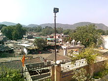
View of Pal village from Shri
Krishna mandir in Pal
378:. It has average elevation of 397 meters from the
310:Ancient and now defunct Hathi Wada in Pal village
1113:
1096:
550:
564:
1103:
1089:
557:
543:
338:
305:
270:
1114:
538:
1054:
448:"Elevation of 21.361853, 75.902929"
13:
14:
1138:
530:
506:"Census of India: Search Details"
286:on the bank of the Suki River in
599:
184:228 km (88 sq mi)
111:
52:
45:
1127:Nashik Division geography stubs
393:
498:
466:
440:
412:
1:
405:
21:Village in Maharashtra, India
1122:Villages in Jalgaon district
1075:. You can help Knowledge by
474:"Tourism - Jalgaon District"
334:
7:
716:Vidhan Sabha constituencies
479:National Informatics Center
53:
10:
1143:
1053:
347:Pal village is located at
301:
192:397 m (1,302 ft)
1017:
781:
715:
694:
608:
597:
573:
425:Government of Maharashtra
282:is a village situated in
261:
249:
232:
222:
217:
209:
201:
196:
188:
180:
175:
165:
160:
148:
136:
124:
106:
71:
40:
33:
26:
695:Lok Sabha constituencies
388:Yawal Wildlife Sanctuary
366:21.361853°N 75.902929°E
1071:location article is a
344:
311:
276:
16:Village in Maharashtra
1035:Pal, Jalgaon district
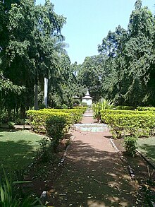
343:Garden at Pal village
342:
309:
274:
223: • Official
213:31/km (80/sq mi)
400:2011 Census of India
371:21.361853; 75.902929
331:in the Pal village.
210: • Density
486:on 8 September 2014
362: /
87: /
1018:Places of interest
782:Towns and villages
454:. 12 November 2014
345:
312:
277:
202: • Total
181: • Total
1084:
1083:
1048:
1047:
914:Nandgaon, Jalgaon
909:Nagardeole Budruk
591:Khandesh District
269:
268:
166: • Type
1134:
1105:
1098:
1091:
1061:Jalgaon district
1055:
603:
566:Jalgaon district
559:
552:
545:
536:
535:
524:
523:
521:
519:
502:
496:
495:
493:
491:
482:. Archived from
470:
464:
463:
461:
459:
444:
438:
437:
435:
433:
416:
377:
376:
374:
373:
372:
367:
363:
360:
359:
358:
355:
298:state of India.
292:Jalgaon district
117:
115:
114:
102:
101:
99:
98:
97:
92:
88:
85:
84:
83:
80:
56:
55:
49:
24:
23:
1142:
1141:
1137:
1136:
1135:
1133:
1132:
1131:
1112:
1111:
1110:
1109:
1051:
1049:
1044:
1013:
777:
711:
690:
604:
595:
569:
563:
533:
528:
527:
517:
515:
511:Census of India
504:
503:
499:
489:
487:
472:
471:
467:
457:
455:
446:
445:
441:
431:
429:
418:
417:
413:
408:
396:
370:
368:
364:
361:
356:
353:
351:
349:
348:
337:
304:
257:
112:
110:
95:
93:
91:21.36°N 75.90°E
89:
86:
81:
78:
76:
74:
73:
67:
66:
65:
64:
63:
62:
61:
57:
36:
29:
22:
17:
12:
11:
5:
1140:
1130:
1129:
1124:
1108:
1107:
1100:
1093:
1085:
1082:
1081:
1046:
1045:
1043:
1042:
1037:
1032:
1027:
1021:
1019:
1015:
1014:
1012:
1011:
1006:
1001:
996:
991:
986:
981:
976:
971:
966:
961:
956:
951:
949:Pimpalgaon Bk.
946:
941:
936:
931:
926:
921:
916:
911:
906:
901:
896:
891:
886:
881:
876:
871:
866:
861:
856:
851:
846:
841:
836:
831:
826:
821:
816:
811:
806:
801:
796:
791:
785:
783:
779:
778:
776:
775:
770:
765:
760:
755:
750:
745:
740:
735:
730:
725:
719:
717:
713:
712:
710:
709:
704:
698:
696:
692:
691:
689:
688:
683:
678:
673:
668:
663:
658:
653:
648:
643:
638:
633:
628:
623:
618:
612:
610:
606:
605:
598:
596:
594:
593:
588:
583:
581:Faruqi dynasty
577:
575:
571:
570:
562:
561:
554:
547:
539:
532:
531:External links
529:
526:
525:
497:
465:
452:veloroutes.org
439:
410:
409:
407:
404:
395:
392:
336:
333:
303:
300:
267:
266:
263:
262:Telephone code
259:
258:
255:
253:
247:
246:
236:
230:
229:
224:
220:
219:
215:
214:
211:
207:
206:
203:
199:
198:
194:
193:
190:
186:
185:
182:
178:
177:
173:
172:
167:
163:
162:
158:
157:
152:
146:
145:
140:
134:
133:
128:
122:
121:
108:
104:
103:
69:
68:
59:
58:
51:
50:
44:
43:
42:
41:
38:
37:
34:
31:
30:
27:
20:
15:
9:
6:
4:
3:
2:
1139:
1128:
1125:
1123:
1120:
1119:
1117:
1106:
1101:
1099:
1094:
1092:
1087:
1086:
1080:
1078:
1074:
1070:
1066:
1062:
1057:
1056:
1052:
1041:
1038:
1036:
1033:
1031:
1028:
1026:
1025:Gandhi Teerth
1023:
1022:
1020:
1016:
1010:
1007:
1005:
1002:
1000:
997:
995:
992:
990:
987:
985:
982:
980:
977:
975:
972:
970:
969:Sangvi Budruk
967:
965:
962:
960:
957:
955:
952:
950:
947:
945:
942:
940:
937:
935:
932:
930:
927:
925:
922:
920:
917:
915:
912:
910:
907:
905:
904:Nagaon Budruk
902:
900:
897:
895:
892:
890:
887:
885:
882:
880:
877:
875:
872:
870:
867:
865:
862:
860:
857:
855:
852:
850:
847:
845:
842:
840:
837:
835:
832:
830:
827:
825:
822:
820:
817:
815:
812:
810:
807:
805:
802:
800:
797:
795:
792:
790:
787:
786:
784:
780:
774:
771:
769:
766:
764:
761:
759:
756:
754:
753:Jalgaon Rural
751:
749:
746:
744:
741:
739:
736:
734:
731:
729:
726:
724:
721:
720:
718:
714:
708:
705:
703:
700:
699:
697:
693:
687:
684:
682:
679:
677:
674:
672:
669:
667:
664:
662:
659:
657:
654:
652:
649:
647:
644:
642:
639:
637:
634:
632:
629:
627:
624:
622:
619:
617:
614:
613:
611:
607:
602:
592:
589:
587:
584:
582:
579:
578:
576:
572:
567:
560:
555:
553:
548:
546:
541:
540:
537:
513:
512:
507:
501:
485:
481:
480:
475:
469:
453:
449:
443:
427:
426:
421:
415:
411:
403:
401:
391:
389:
385:
381:
375:
341:
332:
330:
325:
321:
317:
308:
299:
297:
293:
289:
285:
284:Satpura range
281:
273:
264:
260:
254:
252:
248:
244:
240:
237:
235:
231:
228:
225:
221:
216:
212:
208:
204:
200:
195:
191:
187:
183:
179:
174:
171:
170:Grampanchayat
168:
164:
159:
156:
153:
151:
147:
144:
141:
139:
135:
132:
129:
127:
123:
120:
109:
105:
100:
72:Coordinates:
70:
48:
39:
32:
25:
19:
1077:expanding it
1058:
1050:
1040:Ajanta Caves
1034:
928:
748:Jalgaon City
516:. Retrieved
509:
500:
488:. Retrieved
484:the original
477:
468:
456:. Retrieved
451:
442:
430:. Retrieved
428:. March 1962
423:
414:
397:
394:Demographics
384:hill station
346:
316:British rule
313:
288:Raver tehsil
279:
278:
96:21.36; 75.90
18:
1065:Maharashtra
1030:Mehrun Lake
954:Ratnapimpri
944:Pimpale Sim
864:Khadakdeola
763:Muktainagar
666:Muktainagar
518:12 November
490:13 November
458:12 November
432:12 November
369: /
296:Maharashtra
251:ZIP code(s)
131:Maharashtra
94: /
1116:Categories
919:Nashirabad
733:Chalisgaon
646:Dharangaon
636:Chalisgaon
406:References
357:75°54′11″E
354:21°21′43″N
197:Population
161:Government
1004:Wadikilla
999:Varangaon
979:Shendurni
889:Mehergaon
380:sea level
335:Geography
318:began in
234:Time zone
218:Languages
189:Elevation
959:Sakegaon
934:Pashtane
894:Mhasawad
849:Javkhede
844:Gandhali
834:Chinawal
829:Chaubari
824:Changdev
804:Amalgaon
728:Bhusawal
626:Bhusawal
621:Bhadgaon
586:Khandesh
320:Khandesh
239:UTC+5:30
150:District
143:Khandesh
1009:Waghali
994:Tongaon
899:Nadgaon
879:Kingaon
874:Khiroda
869:Khadake
839:Dahiwad
799:Amadade
768:Pachora
743:Erandol
723:Amalner
702:Jalgaon
671:Pachora
656:Jalgaon
651:Erandol
616:Amalner
609:Tehsils
574:History
398:As per
302:History
256:425-504
227:Marathi
155:Jalgaon
107:Country
82:75°54′E
79:21°22′N
35:Village
989:Sonvad
984:Sonale
964:Sangvi
939:Pilode
859:Kasoda
854:Karjod
794:Alwadi
789:Adavad
758:Jamner
738:Chopda
676:Parola
661:Jamner
641:Chopda
631:Bodwad
568:topics
514:. 2011
265:02-584
138:Region
116:
1069:India
1059:This
974:Savda
924:Nhavi
884:Mangi
819:Bhoje
814:Asoda
809:Amoda
773:Raver
707:Raver
686:Yawal
681:Raver
324:Yawal
205:7,041
126:State
119:India
1073:stub
520:2014
492:2014
460:2014
434:2014
329:wada
176:Area
929:Pal
294:of
290:in
280:Pal
243:IST
60:Pal
28:Pal
1118::
1067:,
1063:,
508:.
476:.
450:.
422:.
1104:e
1097:t
1090:v
1079:.
558:e
551:t
544:v
522:.
494:.
462:.
436:.
245:)
241:(
Text is available under the Creative Commons Attribution-ShareAlike License. Additional terms may apply.


