212:
461:
place in the area; however, by 1973, the Harvey Gum
Factory was on the subject site and structures were either completed or under construction at 1890 Embarcadero Road and 2440-2450 Embarcadero Way. Conditions were identical in the 1974 aerial photograph. In the 1980 aerial photograph, the Harvey Gum Factory is standing, and additional infill construction can be seen in the area such as the Baylands Business Park adjacent and to south of the site and the structure now located at 1860 Embarcadero Road. The Harvey Gum Factory was demolished in 1982, based on Palo Alto Planning Department records.
1304:
198:
1219:
31:
484:
754:
304:
460:
in Menlo Park, California. Comparison of the aerial photographs indicate that no development had begun in the vicinity prior to 1956 other than the Palo Alto
Airport and the Regional Water Quality Control Board Plant (terminus of Embarcadero Way). Between 1956 and 1960, no new development had taken
387:
Facilities at this busy towered airport include a staffed terminal and multiple repair shops: Advantage
Aviation (Cessna & Beechcraft Authorized Service Center), WVAS Inc. dba Aero Works (Diamond Authorized Service Center), Rossi Aircraft, and Peninsula Avionics. The airport is also home to a
388:
number of flying clubs (in order of establishment): Stanford Flying Club (est. 1930), West Valley Flying Club (est. 1973), Sundance Flying Club (est. 2006), and
Advantage Aviation Flying Club. The airport is located within one-half mile of
1323:
445:
The original Palo Alto airport was located adjacent to
Stanford Stadium and was built in the late 1920s. Between 1934 and 1936, a new Palo Alto Airport was built at the airport's current location.
758:
432:
Palo Alto
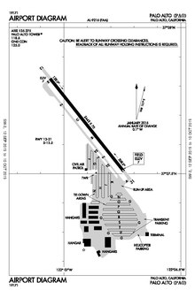
Airport has one approach to runway 31. The RNAV (GPS) approach to runway 31 has 460' MDA/1-mi visibility minimum for category A approaches. The VOR approach has been decommissioned.
1359:
934:
1208:
1374:
1289:
1284:
424:. The airport is also adjacent to a public golf course. Dining options within a short walk include the Abundant Air Cafe, and the Bay Café at the golf course.
927:
1369:
154:
1349:
1243:
1201:
969:
920:
1379:
943:
507:
677:
974:
1354:
1194:
1384:
802:
Earth
Metrics. Inc, "Phase One Environmental Site Assessment, 1870 Embarcadero Road, Palo Alto", Report No. 7897W0.001, June 2, 1989
1328:
561:
502:
1274:
497:
729:
1364:
1253:
1248:
512:
959:
552:
396:
211:
1318:
421:
796:
1222:
1009:
1279:
1048:
557:
453:
331:
67:
964:
863:
403:
353:
1133:
489:
395:
First-time pilots should familiarize themselves with the complex Bay Area airspace, especially the overlying
581:
191:
1093:
1078:
817:
663:
389:
147:
448:
In 1989 a comprehensive area history analysis was conducted by Earth
Metrics, based upon review of extant
1113:
1098:
1028:
70:
1108:
1149:
1043:
1023:
1269:
1068:
990:
826:
822:
806:
City of Palo Alto Staff Report, Palo Alto
Airport Transfer from County of Santa Clara, Aug 11, 2014
875:
805:
851:
1164:
1018:
685:
457:
137:
111:
1123:
1088:
995:
517:
349:
121:
1303:
1083:
8:
1175:
1059:
1033:
951:
912:
334:
1186:
452:. The photo reconnaissance flights were flown in 1956, 1960, 1973, 1974 and 1980 by the
197:
1128:
891:
522:
469:
1218:
1169:
1154:
779:
465:
449:
365:
323:
315:
101:
56:
45:
1103:
1005:
771:. Washington, D.C.: Air Force History and Museums Program, United States Air Force.
406:
399:
377:
342:
262:
895:
698:
881:
832:
416:
Fifteen miles of hiking and biking trails, affording multiple opportunities for
1118:
547:
1343:
1073:
417:
361:
169:
156:
129:
901:
885:
778:. Randolph AFB, Texas: Office of History and Research, Headquarters, AETC.
30:
1159:
783:
631:
410:
357:
125:
645:
232:
869:
632:"Sundance Flying Club, Palo Alto, CA - Affordable Flight Instruction"
905:
846:
345:
381:
219:
595:
1360:
Airfields of the United States Army Air Forces in
California
797:
Santa Clara County Airports official site: Palo Alto Airport
762:
376:
Palo Alto Airport covers 102 acres (41 ha) and has one
942:
303:
1216:
838:
776:
History of Air Education and Training Command, 1942–2002
709:
Landing Fields of the Pacific West | Page=56 | Date=1931
718:
Airfield Bulletins No2 | Page=23 | Date=1934 & 1936
613:
678:"Palo Alto Municipal Golf Course - City of Palo Alto"
420:, form part of the adjacent 1,940-acre (785 ha)
479:
409:. Landing pilots should also watch out for bird and
384:(13/31) measuring 2,443 × 70 ft. (745 × 21 m).
1375:Buildings and structures in Palo Alto, California
1341:
852:PAO Airport Joint Community Relations Committee
769:Locating Air Force Base Sites History’s Legacy
730:"Council votes to take over Palo Alto Airport"
508:List of airports in the San Francisco Bay area
1202:
928:
1370:Airports in Santa Clara County, California
1209:
1195:
935:
921:
210:
196:
548:"Palo Alto Airport of Santa Clara County"
562:United States Department of the Interior
503:35th Flying Training Wing (World War II)
427:
302:
1350:Airports in the San Francisco Bay Area
1342:
944:Airports in the San Francisco Bay Area
498:California World War II Army Airfields
1380:USAAF Western Flying Training Command
1190:
916:
513:List of attractions in Silicon Valley
763:Air Force Historical Research Agency
727:
553:Geographic Names Information System
472:, after a 50-year lease had ended.
13:
1329:Western Technical Training Command
1324:Central Technical Training Command
1319:Eastern Technical Training Command
790:
422:Palo Alto Baylands Nature Preserve
14:
1396:
1355:1940 establishments in California
811:
307:Bird's-eye view of the facilities
1385:American Theater of World War II
1302:
1223:Army Air Forces Training Command
1217:
757: This article incorporates
752:
482:
293:Runway in good condition; lights
285:Runway in good condition; lights
35:Aerial view of Palo Alto Airport
29:
1254:Western Flying Training Command
1249:Central Flying Training Command
1244:Eastern Flying Training Command
890:NOAA/NWS weather observations:
818:City of Palo Alto, airport page
721:
712:
703:
558:United States Geological Survey
454:U.S. Department of the Interior
692:
670:
656:
638:
624:
606:
588:
574:
540:
1:
847:Palo Alto Airport Association
843:, effective September 5, 2024
823:FAA Airport Form 5010 for PAO
528:
490:San Francisco Bay Area portal
371:
1365:Airports established in 1940
870:airport information for KPAO
859:Resources for this airport:
7:
864:airport information for PAO
774:Manning, Thomas A. (2005).
767:Shaw, Frederick J. (2004).
475:
16:Airport in California, U.S.
10:
1401:
746:
664:"Baylands Nature Preserve"
468:took over operations from
456:, and are archived by the
440:
1311:
1300:
1262:
1236:
1229:
1142:
1057:
1004:
983:
950:
289:
281:
277:
272:
239:
236:
231:
227:
218:
209:
204:
185:
146:
135:
117:
107:
97:
89:
84:
40:
28:
21:
876:accident history for PAO
533:
364:, near the south end of
1044:San Jose-Reid–Hillview
854:, report July 11, 2005
759:public domain material
682:www.cityofpaloalto.org
650:advantage-aviation.com
458:U.S. Geological Survey
368:on the western shore.
308:
170:37.46111°N 122.11500°W
112:San Francisco Bay Area
996:Travis Air Force Base
518:Reid-Hillview Airport
428:Instrument approaches
306:
975:Sonoma County–Schulz
175:37.46111; -122.11500
142:7 ft / 2 m
1263:Specialized schools
906:Terminal Procedures
886:live flight tracker
882:airport information
833:FAA Airport Diagram
582:"Palo Alto Airport"
166: /
1312:Technical training
1084:Marin County–Gnoss
1058:General aviation (
902:aeronautical chart
728:Sheyner, Gennady.
523:San Martin Airport
470:Santa Clara County
450:aerial photographs
354:Santa Clara County
309:
1337:
1336:
1298:
1297:
1184:
1183:
829:
466:City of Palo Alto
402:and the abutting
366:San Francisco Bay
312:Palo Alto Airport
301:
300:
297:
296:
268:
267:
102:City of Palo Alto
23:Palo Alto Airport
1392:
1306:
1234:
1233:
1221:
1211:
1204:
1197:
1188:
1187:
1019:Concord-Buchanan
1006:General aviation
937:
930:
923:
914:
913:
842:
825:
756:
755:
740:
739:
737:
736:
725:
719:
716:
710:
707:
701:
696:
690:
689:
684:. Archived from
674:
668:
667:
660:
654:
653:
642:
636:
635:
628:
622:
621:
610:
604:
603:
592:
586:
585:
578:
572:
571:
569:
568:
544:
492:
487:
486:
485:
407:Class C airspace
343:general aviation
279:
278:
229:
228:
222:
214:
200:
195:
194:
192:Official website
181:
180:
178:
177:
176:
171:
167:
164:
163:
162:
159:
77:
76:
63:
62:
52:
51:
33:
19:
18:
1400:
1399:
1395:
1394:
1393:
1391:
1390:
1389:
1340:
1339:
1338:
1333:
1307:
1294:
1280:Glider Training
1275:Contract Flying
1258:
1230:Flying training
1225:
1215:
1185:
1180:
1138:
1053:
1000:
979:
965:San Jose Mineta
946:
941:
896:past three days
836:
814:
793:
791:Further reading
753:
749:
744:
743:
734:
732:
726:
722:
717:
713:
708:
704:
697:
693:
676:
675:
671:
662:
661:
657:
644:
643:
639:
630:
629:
625:
612:
611:
607:
600:flystanford.com
594:
593:
589:
580:
579:
575:
566:
564:
546:
545:
541:
536:
531:
488:
483:
481:
478:
443:
430:
374:
348:in the city of
220:
190:
189:
174:
172:
168:
165:
160:
157:
155:
153:
152:
136:Elevation
80:
74:
66:
60:
55:
49:
44:
36:
24:
17:
12:
11:
5:
1398:
1388:
1387:
1382:
1377:
1372:
1367:
1362:
1357:
1352:
1335:
1334:
1332:
1331:
1326:
1321:
1315:
1313:
1309:
1308:
1301:
1299:
1296:
1295:
1293:
1292:
1287:
1282:
1277:
1272:
1266:
1264:
1260:
1259:
1257:
1256:
1251:
1246:
1240:
1238:
1237:Flying schools
1231:
1227:
1226:
1214:
1213:
1206:
1199:
1191:
1182:
1181:
1179:
1178:
1173:
1167:
1162:
1157:
1152:
1146:
1144:
1140:
1139:
1137:
1136:
1131:
1126:
1121:
1119:Sonoma Skypark
1116:
1111:
1106:
1101:
1096:
1091:
1086:
1081:
1076:
1071:
1069:Angwin–Parrett
1065:
1063:
1055:
1054:
1052:
1051:
1046:
1041:
1036:
1031:
1026:
1021:
1015:
1013:
1002:
1001:
999:
998:
993:
987:
985:
981:
980:
978:
977:
972:
967:
962:
956:
954:
948:
947:
940:
939:
932:
925:
917:
911:
910:
909:
908:
898:
888:
878:
872:
866:
856:
855:
849:
844:
830:
820:
813:
812:External links
810:
809:
808:
803:
800:
792:
789:
788:
787:
772:
765:
748:
745:
742:
741:
720:
711:
702:
691:
688:on 2012-09-25.
669:
655:
637:
623:
605:
587:
573:
538:
537:
535:
532:
530:
527:
526:
525:
520:
515:
510:
505:
500:
494:
493:
477:
474:
442:
439:
438:
437:
429:
426:
390:U.S. Route 101
373:
370:
299:
298:
295:
294:
291:
287:
286:
283:
275:
274:
270:
269:
266:
265:
260:
257:
254:
250:
249:
246:
242:
241:
238:
235:
225:
224:
216:
215:
207:
206:
202:
201:
187:
183:
182:
150:
144:
143:
140:
133:
132:
119:
115:
114:
109:
105:
104:
99:
95:
94:
91:
87:
86:
82:
81:
79:
78:
64:
53:
41:
38:
37:
34:
26:
25:
22:
15:
9:
6:
4:
3:
2:
1397:
1386:
1383:
1381:
1378:
1376:
1373:
1371:
1368:
1366:
1363:
1361:
1358:
1356:
1353:
1351:
1348:
1347:
1345:
1330:
1327:
1325:
1322:
1320:
1317:
1316:
1314:
1310:
1305:
1291:
1288:
1286:
1283:
1281:
1278:
1276:
1273:
1271:
1268:
1267:
1265:
1261:
1255:
1252:
1250:
1247:
1245:
1242:
1241:
1239:
1235:
1232:
1228:
1224:
1220:
1212:
1207:
1205:
1200:
1198:
1193:
1192:
1189:
1177:
1174:
1171:
1168:
1166:
1163:
1161:
1158:
1156:
1153:
1151:
1148:
1147:
1145:
1141:
1135:
1132:
1130:
1127:
1125:
1124:Sonoma Valley
1122:
1120:
1117:
1115:
1112:
1110:
1107:
1105:
1102:
1100:
1097:
1095:
1092:
1090:
1089:Half Moon Bay
1087:
1085:
1082:
1080:
1077:
1075:
1072:
1070:
1067:
1066:
1064:
1061:
1056:
1050:
1047:
1045:
1042:
1040:
1037:
1035:
1032:
1030:
1027:
1025:
1022:
1020:
1017:
1016:
1014:
1011:
1007:
1003:
997:
994:
992:
989:
988:
986:
982:
976:
973:
971:
968:
966:
963:
961:
960:San Francisco
958:
957:
955:
953:
949:
945:
938:
933:
931:
926:
924:
919:
918:
915:
907:
903:
899:
897:
893:
889:
887:
883:
879:
877:
873:
871:
867:
865:
861:
860:
858:
857:
853:
850:
848:
845:
840:
834:
831:
828:
824:
821:
819:
816:
815:
807:
804:
801:
799:, web archive
798:
795:
794:
785:
781:
777:
773:
770:
766:
764:
761:from the
760:
751:
750:
731:
724:
715:
706:
700:
699:GPS Runway 31
695:
687:
683:
679:
673:
665:
659:
651:
647:
641:
633:
627:
619:
615:
609:
601:
597:
591:
583:
577:
563:
559:
555:
554:
549:
543:
539:
524:
521:
519:
516:
514:
511:
509:
506:
504:
501:
499:
496:
495:
491:
480:
473:
471:
467:
462:
459:
455:
451:
446:
436:GPS Runway 31
435:
434:
433:
425:
423:
419:
414:
412:
408:
405:
401:
398:
393:
391:
385:
383:
379:
369:
367:
363:
362:United States
359:
355:
351:
347:
344:
340:
336:
333:
329:
325:
321:
317:
313:
305:
292:
288:
284:
280:
276:
271:
264:
261:
258:
255:
252:
251:
247:
244:
243:
234:
230:
226:
223:
217:
213:
208:
203:
199:
193:
188:
184:
179:
151:
149:
145:
141:
139:
134:
131:
127:
123:
120:
116:
113:
110:
106:
103:
100:
96:
92:
88:
83:
72:
69:
65:
58:
54:
47:
43:
42:
39:
32:
27:
20:
1165:Hamilton AAF
1160:Crissy Field
1038:
880:FlightAware
775:
768:
733:. Retrieved
723:
714:
705:
694:
686:the original
681:
672:
658:
649:
640:
626:
617:
608:
599:
590:
576:
565:. Retrieved
551:
542:
464:In 2015 the
463:
447:
444:
431:
418:birdwatching
415:
394:
386:
375:
338:
327:
319:
311:
310:
90:Airport type
1150:NAS Alameda
1134:Watsonville
1034:Napa County
173: /
161:122°06′54″W
148:Coordinates
1344:Categories
1270:Bombardier
1176:Santa Cruz
1172:(original)
1143:Historical
1129:San Martin
1094:Healdsburg
1079:Cloverdale
1049:San Carlos
952:Commercial
900:SkyVector
735:2017-06-13
567:2009-05-04
529:References
413:activity.
411:jackrabbit
372:Facilities
358:California
273:Statistics
158:37°27′40″N
126:California
1290:Navigator
1170:Rio Vista
1155:Alum Rock
1114:Rio Vista
1099:Hollister
1060:non-tower
1039:Palo Alto
1029:Livermore
784:276858370
350:Palo Alto
290:Runway 13
282:Runway 31
233:Direction
122:Palo Alto
1109:Petaluma
1104:Nut Tree
618:wvfc.org
476:See also
240:Surface
118:Location
98:Operator
1285:Gunnery
1024:Hayward
991:Moffett
984:Federal
970:Oakland
892:current
868:AirNav
747:Sources
441:History
400:Class B
378:asphalt
346:airport
341:) is a
263:Asphalt
237:Length
221:Runways
186:Website
85:Summary
835:
782:
646:"Home"
614:"Home"
596:"Home"
382:runway
380:paved
256:2,443
253:13/31
108:Serves
93:Public
1074:Byron
1010:tower
534:Notes
884:and
874:ASN
862:FAA
780:OCLC
328:KPAO
324:ICAO
316:IATA
259:745
138:AMSL
130:U.S.
61:KPAO
57:ICAO
46:IATA
839:PDF
827:PDF
404:SJC
397:SFO
352:in
339:PAO
335:LID
332:FAA
320:PAO
245:ft
205:Map
75:PAO
71:LID
68:FAA
50:PAO
1346::
904:,
894:,
680:.
648:.
616:.
598:.
560:,
556:.
550:.
392:.
360:,
356:,
337::
330:,
326::
322:,
318::
248:m
128:,
124:,
73::
59::
48::
1210:e
1203:t
1196:v
1062:)
1012:)
1008:(
936:e
929:t
922:v
841:)
837:(
786:.
738:.
666:.
652:.
634:.
620:.
602:.
584:.
570:.
314:(
Text is available under the Creative Commons Attribution-ShareAlike License. Additional terms may apply.