239:
52:
517:
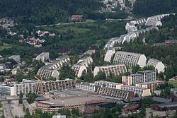
272:". Østre Aker merged with Oslo in 1948, both instigated and followed by a massive expansion of the city settlement. Today's Stovner borough is constructed atop the home fields of the Stovner farm, the first record of which dates back to the 14th century, as well as on the fields of several other farms that were situated in the area covered by the borough. The bulk of the modern high-rise structures were built by
536:
40:
333:
67:
299:
Stovner is the borough in Oslo and Norway with the highest density of immigrants. The proportion of newborns with an immigrant background was per. 2017 at 80%
77:
273:
577:
601:
119:
398:
606:
207:
570:
596:
407:
257:
30:
51:
280:
line into central Oslo, and an administrative center for the borough. The last three stations of
66:
563:
186:
196:
486:
8:
238:
131:
459:
391:
311:
289:
242:
447:
427:
293:
285:
356:"(+) Petter hadde drømmen klar. Så stoppet hjertet: – Hele verden sluknet for meg"
551:
547:
491:
276:
and completed in the first half of the 1970s, together with several schools, a
590:
480:
469:
384:
220:
136:
92:
79:
269:
230:
506:
464:
453:
355:
281:
277:
268:. Historically, Stovner was the name of a farm in the municipal borough "
437:
177:
376:
215:
432:
516:
501:
474:
442:
265:
246:
203:
182:
112:
39:
535:
543:
422:
411:
334:"Befolkningen etter bydel, kjønn og aldersgrupper 1.1.2020"
261:
124:
300:
331:
588:
571:
392:
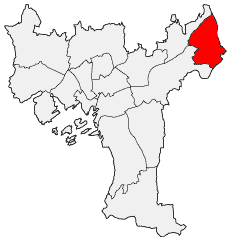
260:located to the far north east of the city of
578:
564:
399:
385:
314:(born 1993), professional football coach
237:
589:
380:
151:8.250 km (3.185 sq mi)
530:
406:
13:
14:
618:
305:
534:
515:
65:
50:
38:
348:
325:
296:— are in the Stovner borough.
1:
332:Municipality of Oslo (2020).
318:
231:bydel-stovner.oslo.kommune.no
550:. You can help Knowledge by
172:4,038/km (10,460/sq mi)
7:
10:
623:
529:
362:(in Norwegian). 2021-06-12
602:Ethnic enclaves in Norway
513:
418:
226:
214:
193:
176:
168:
160:
155:
147:
142:
130:
118:
108:
73:
64:
46:
37:
28:
21:
546:location article is a
250:
241:
195: • Summer (
93:59.96111°N 10.92667°E
607:Oslo geography stubs
169: • Density
89: /
312:Petter Skogsletten
251:
161: • Total
148: • Total
98:59.96111; 10.92667
559:
558:
524:
523:
487:Søndre Nordstrand
236:
235:
16:Borough in Norway
614:
597:Boroughs of Oslo
580:
573:
566:
538:
531:
519:
401:
394:
387:
378:
377:
371:
370:
368:
367:
352:
346:
345:
343:
341:
329:
200:
104:
103:
101:
100:
99:
94:
90:
87:
86:
85:
82:
69:
54:
42:
19:
18:
622:
621:
617:
616:
615:
613:
612:
611:
587:
586:
585:
584:
527:
525:
520:
511:
414:
405:
375:
374:
365:
363:
354:
353:
349:
339:
337:
330:
326:
321:
308:
243:Stovner Station
194:
97:
95:
91:
88:
83:
80:
78:
76:
75:
60:
59:
58:
57:
33:
24:
17:
12:
11:
5:
620:
610:
609:
604:
599:
583:
582:
575:
568:
560:
557:
556:
539:
522:
521:
514:
512:
510:
509:
504:
499:
494:
492:St. Hanshaugen
489:
484:
477:
472:
467:
462:
457:
450:
445:
440:
435:
430:
425:
419:
416:
415:
404:
403:
396:
389:
381:
373:
372:
347:
336:(in Norwegian)
323:
322:
320:
317:
316:
315:
307:
306:Notable people
304:
234:
233:
228:
224:
223:
218:
212:
211:
201:
191:
190:
180:
174:
173:
170:
166:
165:
162:
158:
157:
153:
152:
149:
145:
144:
140:
139:
134:
128:
127:
122:
116:
115:
110:
106:
105:
71:
70:
62:
61:
55:
49:
48:
47:
44:
43:
35:
34:
29:
26:
25:
22:
15:
9:
6:
4:
3:
2:
619:
608:
605:
603:
600:
598:
595:
594:
592:
581:
576:
574:
569:
567:
562:
561:
555:
553:
549:
545:
540:
537:
533:
532:
528:
518:
508:
505:
503:
500:
498:
495:
493:
490:
488:
485:
482:
478:
476:
473:
471:
468:
466:
463:
461:
458:
455:
451:
449:
446:
444:
441:
439:
436:
434:
431:
429:
426:
424:
421:
420:
417:
413:
409:
402:
397:
395:
390:
388:
383:
382:
379:
361:
357:
351:
335:
328:
324:
313:
310:
309:
303:
301:
297:
295:
291:
287:
283:
279:
275:
271:
267:
263:
259:
255:
248:
244:
240:
232:
229:
225:
222:
219:
217:
216:ISO 3166 code
213:
209:
205:
202:
198:
192:
188:
184:
181:
179:
175:
171:
167:
163:
159:
154:
150:
146:
141:
138:
137:Grorud Valley
135:
133:
129:
126:
123:
121:
117:
114:
111:
107:
102:
74:Coordinates:
72:
68:
63:
53:
45:
41:
36:
32:
27:
23:Bydel Stovner
20:
552:expanding it
541:
526:
496:
364:. Retrieved
359:
350:
338:. Retrieved
327:
298:
253:
252:
56:Coat of arms
507:Vestre Aker
465:Nordre Aker
448:Grünerløkka
282:Grorudbanen
96: /
591:Categories
460:Nordstrand
438:Gamle Oslo
366:2023-06-20
360:Nettavisen
319:References
270:Østre Aker
156:Population
84:10°55′36″E
81:59°57′40″N
221:NO-030111
178:Time zone
470:Østensjø
408:Boroughs
340:29 April
132:District
497:Stovner
481:Sentrum
433:Frogner
290:Stovner
274:Selvaag
258:borough
254:Stovner
227:Website
109:Country
31:Borough
502:Ullern
475:Sagene
443:Grorud
428:Bjerke
294:Vestli
286:Rommen
278:subway
266:Norway
247:T-bane
164:33,316
113:Norway
542:This
454:Marka
256:is a
204:UTC+2
183:UTC+1
548:stub
544:Oslo
423:Alna
412:Oslo
342:2020
292:and
262:Oslo
208:CEST
143:Area
125:Oslo
120:City
410:of
197:DST
187:CET
593::
358:.
302:.
288:,
284:—
264:,
579:e
572:t
565:v
554:.
483:)
479:(
456:)
452:(
400:e
393:t
386:v
369:.
344:.
249:)
245:(
210:)
206:(
199:)
189:)
185:(
Text is available under the Creative Commons Attribution-ShareAlike License. Additional terms may apply.


