45:
148:
233:
172:
274:
164:
269:
is a computer system that allows for visualizing, manipulating, capturing, and storage of data with associated attributes. GIS offers better understanding of patterns and relationships of the landscape at different scales. Tools inside the GIS allow for manipulation of data for spatial analysis or
316:
USGS (United States
Geologic Survey) is developing a 3D Elevation Program (3DEP) to keep up with growing needs for high quality topographic data. 3DEP is a collection of enhanced elevation data in the form of high quality LiDAR data over the conterminous United States, Hawaii, and the U.S.
213:
200:
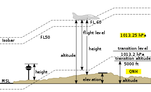
as the highest point of the landing area. It is often measured in feet and can be found in approach charts of the aerodrome. It is not to be confused with terms such as the
616:
386:
469:
317:
territories. There are three bare earth DEM layers in 3DEP which are nationally seamless at the resolution of 1/3, 1, and 2 arcseconds.
401:
17:
371:
568:
556:
376:
502:
381:
298:
266:
606:
440:
621:
278:
31:
460:
531:
326:
152:
407:
302:
121:
430:
96:
425:
310:
92:
137:
128:
Elevation is not to be confused with the distance from the center of the Earth. Due to the
60:
8:
601:
339:
156:
111:
48:
Processed LiDAR point cloud showing not only elevation, but heights of features as well.
44:
611:
536:
420:
415:
74:
391:
360:
252:
147:
38:
305:(DEM) are commonly used to represent the surface (topography) of a place, through a
260:
232:
596:
565:
553:
129:
306:
286:
217:
468:. Montreal, Canada: International Civic Aviation Organisation. 1951. p. 9.
281:, normalized as 8-bit grayscale, where lighter values indicate higher elevation.
273:
248:
581:
171:
590:
572:
560:
133:
86:
294:
256:
494:
115:
is used for points above the surface, such as an aircraft in flight or a
89:
179:
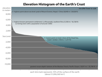
of the Earth's surface, of which approximately 71% is covered with water
435:
365:
116:
57:
103:
is mainly used when referring to points on the Earth's surface, while
221:
176:
163:
82:
201:
105:
69:
above or below a fixed reference point, most commonly a reference
349:
344:
236:
212:
577:
548:
354:
225:
66:
78:
70:
27:
Height of a geographic location above a fixed reference point
526:
244:
240:
197:
141:
277:
Heightmap of Earth's surface (including water and ice) in
140:
have, respectively, the largest elevation and the largest
290:
543:
410:, a superseded United States vertical datum, (NGVD 29)
566:
Downloadable ETOPO5 Raw Data
Database (5 minute grid)
554:
Downloadable ETOPO2 Raw Data
Database (2 minute grid)
537:
NGVD 29 to NAVD 88 online elevation converter @ NGS
387:List of the highest major summits of North America
588:
313:are another way to represent terrain in GIS.
582:Path’s Elevation Profile using Google Earth
617:Geographical terminology in mountaineering
151:Sign at 8,000 feet (2,438 m) in the
293:used to depict elevation, often through
272:
231:
211:
170:
162:
146:
43:
37:For broader coverage of this topic, see
544:United States Geological Survey website
14:
589:
125:is used for points below the surface.
527:U.S. National Geodetic Survey website
402:North American Vertical Datum of 1988
330:
394:, German vertical datum, literally:
372:List of European cities by elevation
24:
492:
377:List of highest mountains on Earth
25:
633:
520:
382:List of highest towns by country
578:Find the elevation of any place
505:from the original on 2018-06-24
475:from the original on 2021-05-07
207:
97:Geodetic datum § Vertical datum
486:
453:
309:(grid) dataset of elevations.
13:
1:
549:Geographical Survey Institute
495:"The National Map: Elevation"
446:
368:, or the adiabatic lapse rate
299:Geographic Information System
267:geographic information system
167:Vertical distance comparison
7:
441:Vertical pressure variation
336:(NAP), Dutch vertical datum
320:
183:
10:
638:
279:equirectangular projection
36:
32:Elevation (disambiguation)
29:
493:Survey, U.S. Geological.
327:Amsterdam Ordnance Datum
303:digital elevation models
153:San Bernardino Mountains
532:Geodetic Glossary @ NGS
408:Sea Level Datum of 1929
396:standard elevation zero
334:Normaal Amsterdams Peil
431:Topographic prominence
311:Digital terrain models
282:
262:
229:
188:In aviation, the term
180:
168:
160:
49:
426:Topographic isolation
276:
235:
228:), showing elevation.
215:
174:
166:
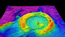
150:
47:
18:Topographic elevation
289:is the main type of
30:For other uses, see
194:aerodrome elevation
157:southern California
112:geopotential height
607:Physical geography
421:Physical geography
416:Orthometric height
283:
263:
259:in the foreground.
230:
196:is defined by the
181:
169:
161:
75:mathematical model
50:
622:Vertical position
361:Hypsometric tints
340:Elevation profile
287:topographical map
253:Cape of Good Hope
132:, the summits of
39:Vertical position
16:(Redirected from
629:
514:
513:
511:
510:
490:
484:
483:
481:
480:
474:
467:
457:
332:
130:equatorial bulge
21:
637:
636:
632:
631:
630:
628:
627:
626:
587:
586:
523:
518:
517:
508:
506:
499:nationalmap.gov
491:
487:
478:
476:
472:
465:
459:
458:
454:
449:
392:Normalhöhennull
323:
218:topographic map
210:
186:
42:
35:
28:
23:
22:
15:
12:
11:
5:
635:
625:
624:
619:
614:
609:
604:
599:
585:
584:
575:
571:2012-12-14 at
563:
559:2012-12-14 at
551:
546:
541:
540:
539:
534:
522:
521:External links
519:
516:
515:
485:
451:
450:
448:
445:
444:
443:
438:
433:
428:
423:
418:
413:
412:
411:
399:
389:
384:
379:
374:
369:
363:
358:
352:
347:
342:
337:
322:
319:
249:Cape Peninsula
247:, showing the
209:
206:
185:
182:
119:in orbit, and
26:
9:
6:
4:
3:
2:
634:
623:
620:
618:
615:
613:
610:
608:
605:
603:
600:
598:
595:
594:
592:
583:
579:
576:
574:
573:archive.today
570:
567:
564:
562:
561:archive.today
558:
555:
552:
550:
547:
545:
542:
538:
535:
533:
530:
529:
528:
525:
524:
504:
500:
496:
489:
471:
464:
463:
456:
452:
442:
439:
437:
434:
432:
429:
427:
424:
422:
419:
417:
414:
409:
406:
405:
403:
400:
397:
393:
390:
388:
385:
383:
380:
378:
375:
373:
370:
367:
364:
362:
359:
356:
353:
351:
348:
346:
343:
341:
338:
335:
328:
325:
324:
318:
314:
312:
308:
304:
300:
296:
295:contour lines
292:
288:
280:
275:
271:
268:
261:
258:
254:
250:
246:
243:Elevation by
242:
238:
234:
227:
223:
219:
214:
205:
203:
199:
195:
191:
178:
173:
165:
158:
154:
149:
145:
143:
139:
135:
134:Mount Everest
131:
126:
124:
123:
118:
114:
113:
108:
107:
102:
98:
94:
91:
90:gravitational
88:
87:equipotential
84:
80:
76:
72:
68:
64:
63:
59:
55:
46:
40:
33:
19:
507:. Retrieved
498:
488:
477:. Retrieved
461:
455:
404:, (NAVD 88)
395:
333:
315:
284:
270:cartography.
264:
257:South Africa
208:Maps and GIS
193:
189:
187:
127:
120:
110:
104:
100:
99:). The term
61:
53:
51:
239:Image over
204:or height.
602:Topography
591:Categories
509:2017-02-24
479:2020-12-19
462:AERODROMES
447:References
436:Topography
366:Lapse rate
216:Part of a
175:Elevation
144:distance.
142:geocentric
138:Chimborazo
117:spacecraft
58:geographic
612:Surveying
357:, general
222:Haleakala
190:elevation
177:histogram
101:elevation
83:sea level
54:elevation
569:Archived
557:Archived
503:Archived
470:Archived
321:See also
202:altitude
184:Aviation
106:altitude
62:location
597:Geodesy
398:, (NHN)
350:GTOPO30
345:Geodesy
301:(GIS),
297:. In a
265:GIS or
237:Landsat
93:surface
77:of the
65:is its
355:Height
331:a.k.a.
307:raster
226:Hawaii
159:(2009)
85:as an
67:height
473:(PDF)
466:(PDF)
122:depth
95:(see
79:Earth
71:geoid
56:of a
251:and
245:NASA
241:SRTM
198:ICAO
136:and
73:, a
52:The
291:map
220:of
192:or
155:of
109:or
81:'s
593::
501:.
497:.
329:,
285:A
255:,
580:*
512:.
482:.
224:(
41:.
34:.
20:)
Text is available under the Creative Commons Attribution-ShareAlike License. Additional terms may apply.


