220:, grazing cattle on the plain with a communal form of land ownership. The Sangu were concentrated in the southern part of the plain, which was more amenable to cattle grazing. In the 1960s the Tanzanian government organized an irrigation project and developed three large rice farms on the plain, watered by streams originating in the western mountains. Some former communal grazing lands have been brought under state control. Now many Sangu make a living in agriculture. Many people from elsewhere in Tanzania have moved to the region to farm or graze livestock.
40:
164:. The Usangu Fault scarp runs along the northern edge of the plain, where the Mbeya Mountains and Lupa upland meet the plain. The Chimala fault scarp marks the southern edge of the Usangu basin, defining the northern edge of the Kipengere and Udzungwa mountains.
145:
rise steeply to the northwest, and the lower Lupa upland further to the east. Further east the Usangu escarpment becomes less distinct, and the plain transitions into the plateau of central
Tanzania.
292:
270:
244:
173:
297:
254:"Southern Acacia-Commiphora bushlands and thickets". World Wildlife Fund ecoregion profile. Accessed 8 September 2019.
83:
239:
Mbede, E. I. (2002). "Interpretation of
Reflection Seismic Data from the Usangu Basin, East African Rift System.
287:
17:
76:
133:
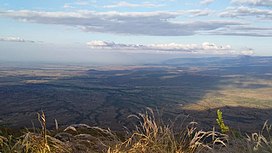
The Usangu Plain covers an area of 15,500 km. It extends northeast-southwest, bounded on the south by the
302:
141:
on the southwest. Between the two ranges the
Makambako Gap opens to the south. On the north, The
195:
along the southern end of the plain, on the lower slopes of the plateaus and the
Makambako Gap.
198:
The Great Ruaha River forms extensive wetlands, some seasonal, in the middle of the plain.
192:
8:
201:
134:
265:
Charnley, Susan (1996). Pastoralism and the Demise of
Communal Property in Tanzania".
161:
149:
255:
39:
142:
138:
281:
98:
85:
65:
213:
122:
69:
217:
187:
176:
55:
181:
121:
is a lowland in south-central
Tanzania. It is named for the
204:
occupies the eastern and central portion of the plain.
179:, with extensive grasslands punctuated by woodlands of
293:Southern Acacia-Commiphora bushlands and thickets
174:Southern Acacia-Commiphora bushlands and thickets
279:
243:, Vol. 28(1) 2002. Accessed 8 September 2019.
160:The Usangu Plain is the eastern branch of the
269:, March 1996. Accessed 8 September 2019.
235:
233:
14:
280:
230:
24:
25:
314:
27:Lowland in south-central Tanzania
298:Important Bird Areas of Tanzania
38:
259:
248:
13:
1:
223:
172:Most of the region is in the
241:Tanzanian Journal of Science
148:The plain is drained by the
128:
7:
10:
319:
191:trees. There are areas of
167:
155:
207:
75:
61:
51:
46:
37:
32:
288:Landforms of Tanzania
212:Until the 1960s, the
152:and its tributaries.
202:Ruaha National Park
193:dry miombo woodland
95: /
135:Udzungwa Mountains
303:Great Ruaha River
267:Cultural Survival
162:East African Rift
150:Great Ruaha River
115:
114:
16:(Redirected from
310:
272:
263:
257:
252:
246:
237:
110:
109:
107:
106:
105:
100:
96:
93:
92:
91:
88:
42:
30:
29:
21:
318:
317:
313:
312:
311:
309:
308:
307:
278:
277:
276:
275:
264:
260:
253:
249:
238:
231:
226:
210:
170:
158:
143:Mbeya Mountains
139:Kipengere Range
131:
103:
101:
97:
94:
89:
86:
84:
82:
81:
28:
23:
22:
15:
12:
11:
5:
316:
306:
305:
300:
295:
290:
274:
273:
258:
247:
228:
227:
225:
222:
209:
206:
169:
166:
157:
154:
130:
127:
113:
112:
79:
73:
72:
63:
62:State/Province
59:
58:
53:
49:
48:
44:
43:
35:
34:
26:
9:
6:
4:
3:
2:
315:
304:
301:
299:
296:
294:
291:
289:
286:
285:
283:
271:
268:
262:
256:
251:
245:
242:
236:
234:
229:
221:
219:
215:
205:
203:
199:
196:
194:
190:
189:
184:
183:
178:
175:
165:
163:
153:
151:
146:
144:
140:
136:
126:
124:
120:
108:
99:8.56°S 34.2°E
80:
78:
74:
71:
67:
64:
60:
57:
54:
50:
45:
41:
36:
31:
19:
18:Usangu Plains
266:
261:
250:
240:
218:pastoralists
216:were mostly
214:Sangu people
211:
200:
197:
186:
180:
171:
159:
147:
132:
123:Sangu people
119:Usangu Plain
118:
116:
33:Usangu Plain
104:-8.56; 34.2
102: /
77:Coordinates
282:Categories
224:References
188:Commiphora
137:, and the
177:ecoregion
129:Geography
47:Geography
56:Tanzania
168:Ecology
156:Geology
111:
90:34°12′E
52:Country
208:People
182:Acacia
87:8°34′S
66:Iringa
70:Mbeya
185:and
117:The
284::
232:^
125:.
68:,
20:)
Text is available under the Creative Commons Attribution-ShareAlike License. Additional terms may apply.
