271:
from the late 19th century and the skillfully integrated buildings from the collective farm period will attract your attention. In 1970, an extension was attached to the single-storey classicistic main building of the Väätsa manor. The manor's stable has been reconstructed as a guesthouse. The irregularly shaped manor complex is integrated with a park with a moderate range of species, a pond in the southern part and a boundary wall around it. Immediately to the south, west and north of the manor you can see modern buildings. An artificial lake created on the Lokuta River helps make Väätsa borough more impressive. The lake has a varied shoreline and fine detached houses on the western and eastern shores.
393:
71:
46:
425:
120:
86:
61:
103:
270:
The landscape at Väätsa is an area with large cultivated fields and neat woodland in the northern part of the Türi drumlins and in the upper courses of the Lokuta and
Reopalu rivers. In the borough of Väätsa, the manor complex and park dating from the early 19th century, the historic commune house
208:. The municipality had a population of 1,479 (as of 1 January 2004) and covered an area of 195.33 km. The population density was 7.6 inhabitants per km.
331:
536:
531:
382:
360:
392:
70:
424:
255:
85:
60:
223:
215:
251:
414:
259:
396:
197:
36:
375:
96:
45:
239:
390:
505:
368:
8:
113:
189:
288:
439:
400:
205:
123:
119:
470:
444:
525:
495:
480:
475:
346:
333:
490:
485:
465:
500:
460:
212:
133:
227:
231:
247:
102:
243:
235:
201:
106:
318:
177:
222:). There were also 10 villages in Väätsa Parish:
523:
211:Administrative centre of the municipality was
19:Former municipality of Estonia in Järva County
376:
383:
369:
524:
148:195.33 km (75.42 sq mi)
364:
13:
281:
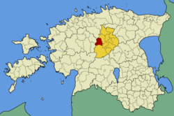
90:Väätsa Parish within Järva County.
14:
548:
310:
537:Populated places in Järva County
532:Former municipalities of Estonia
423:
391:
118:
101:
84:
69:
59:
44:
37:Former municipality of Estonia
16:Former municipality of Estonia
1:
274:
265:
7:
10:
553:
453:
432:
421:
407:
173:
165:
157:
152:
144:
139:
129:
112:
95:
83:
55:
43:
34:
24:
193:
169:7.6/km (20/sq mi)
454:Former municipalities
130:Administrative centre
433:Rural municipalities
166: • Density
343: /
204:. It was a part of
408:Urban municipality
158: • Total
145: • Total
519:
518:
347:58.883°N 25.450°E
289:"X-GIS(3) Portal"
183:
182:
544:
427:
395:
385:
378:
371:
362:
361:
358:
357:
355:
354:
353:
348:
344:
341:
340:
339:
336:
325:
322:
321:
319:Official website
304:
303:
301:
299:
285:
122:
105:
88:
73:
63:
48:
22:
21:
552:
551:
547:
546:
545:
543:
542:
541:
522:
521:
520:
515:
449:
428:
419:
403:
389:
351:
349:
345:
342:
337:
334:
332:
330:
329:
323:
317:
316:
313:
308:
307:
297:
295:
293:xgis.maaamet.ee
287:
286:
282:
277:
268:
91:
79:
78:
77:
76:
67:
66:
51:
39:
30:
27:
20:
17:
12:
11:
5:
550:
540:
539:
534:
517:
516:
514:
513:
508:
503:
498:
493:
488:
483:
478:
473:
468:
463:
457:
455:
451:
450:
448:
447:
442:
436:
434:
430:
429:
422:
420:
418:
417:
411:
409:
405:
404:
397:Municipalities
388:
387:
380:
373:
365:
352:58.883; 25.450
327:
326:
312:
311:External links
309:
306:
305:
279:
278:
276:
273:
267:
264:
196:) was a rural
181:
180:
175:
171:
170:
167:
163:
162:
159:
155:
154:
150:
149:
146:
142:
141:
137:
136:
131:
127:
126:
116:
110:
109:
99:
93:
92:
89:
81:
80:
74:
68:
64:
58:
57:
56:
53:
52:
49:
41:
40:
35:
32:
31:
28:
25:
18:
15:
9:
6:
4:
3:
2:
549:
538:
535:
533:
530:
529:
527:
512:
509:
507:
506:Roosna-Alliku
504:
502:
499:
497:
494:
492:
489:
487:
484:
482:
479:
477:
474:
472:
469:
467:
464:
462:
459:
458:
456:
452:
446:
443:
441:
438:
437:
435:
431:
426:
416:
413:
412:
410:
406:
402:
398:
394:
386:
381:
379:
374:
372:
367:
366:
363:
359:
356:
324:(in Estonian)
320:
315:
314:
294:
290:
284:
280:
272:
263:
261:
257:
253:
249:
245:
241:
237:
233:
229:
225:
221:
217:
216:small borough
214:
209:
207:
203:
199:
195:
191:
187:
186:Väätsa Parish
179:
178:www.vaatsa.ee
176:
172:
168:
164:
160:
156:
151:
147:
143:
138:
135:
132:
128:
125:
121:
117:
115:
111:
108:
104:
100:
98:
94:
87:
82:
72:
62:
54:
47:
42:
38:
33:
26:Väätsa Parish
23:
510:
401:Järva County
328:
296:. Retrieved
292:
283:
269:
219:
210:
206:Järva County
198:municipality
185:
184:
124:Järva County
75:Coat of arms
350: /
256:Väljataguse
200:in central
194:Väätsa vald
29:Väätsa vald
526:Categories
298:3 February
275:References
153:Population
50:Väätsa bog
266:Geography
260:Vissuvere
232:Piiumetsa
224:Aasuvälja
248:Saueaugu
190:Estonian
471:Imavere
338:25°27′E
335:58°53′N
244:Roovere
236:Reopalu
202:Estonia
174:Website
107:Estonia
97:Country
511:Väätsa
496:Lehtse
481:Kareda
476:Kabala
252:Ülejõe
220:alevik
213:Väätsa
134:Väätsa
114:County
491:Koigi
486:Koeru
466:Ambla
440:Järva
415:Paide
228:Lõõla
161:1,479
501:Oisu
461:Albu
445:Türi
300:2022
140:Area
65:Flag
399:of
240:Röa
528::
291:.
262:.
258:,
254:,
250:,
246:,
242:,
238:,
234:,
230:,
226:,
192::
384:e
377:t
370:v
302:.
218:(
188:(
Text is available under the Creative Commons Attribution-ShareAlike License. Additional terms may apply.


