443:
31:
161:
The Zuari is 92 km long, but is connected to other rivers and canals such as
Mandovi river (62 km in length) and Cumbarjua Canal (15 km). The other rivers in Goa are shorter such as Terekhol (22 km), Chapora (29 km), Baga (5 km), Sal (16 km), Talpona (11 km),
261:
Shetye, S. R., Gouveia, A. D., Singbal, S. Y., Naik, C. G., Sundar, D., Michael, G. S., & Nampoothiri, G. (1995). Propagation of tides in the
Mandovi-Zuari estuarine network. Proceedings of the Indian Academy of Sciences-Earth and Planetary Sciences, 104(4),
238:
Dehadrai, P. V. (1970, August), Changes in the environmental features of the Zuari and
Mandovi estuaries in relation to tides, In Proceedings of the Indian Academy of Sciences-Section B (Vol. 72, No. 2, pp. 68-80), Springer
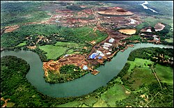
158:. The Zuari is also referred to as the Aghanashani in the interior regions. It flows in a south-westerly direction through the talukas of Tiswadi, Ponda, Mormugao, Salcete, Sanguem and Quepem.
229:
Pawar Anant, Study of
Mangrove flora along the Zuari River, International Research Journal of Environment Sciences, Vol. 1(5), 35-39, December (2012)
163:
271:
167:
171:
322:
534:
162:
and
Galgibag (4 km). Their lengths and widths vary with tidal and other seasonal flooding. The tributaries of Zuari include
488:
558:
249:
248:
Qasim, S. Z., & Sen Gupta, R. (1981). Environmental characteristics of the
Mandovi-Zuari estuarine system in Goa.
315:
527:
563:
308:
568:
481:
520:
553:
474:
8:
198:
508:
462:
364:
181:
form an estuarine system. They are the backbone of Goa's agricultural industry. The
185:, linking the two rivers has enabled ships navigate to the interior regions to the
390:
182:
504:
458:
369:
547:
422:
354:
349:
286:
273:
178:
155:
406:
359:
331:
190:
151:
83:
68:
210:
300:
194:
189:
mines. The waters of the
Mandovi and Zuari both flush out into the
186:
138:
30:
442:
450:
147:
87:
46:
454:
335:
143:
56:
545:
503:This article related to a river in India is a
528:
482:
316:
193:at Cabo Aguada, a common point forming the
535:
521:
489:
475:
449:This article related to a location in the
323:
309:
154:which originates at Hemad-Barshem in the
142:) is the largest river in the state of
546:
330:
201:lies on the mouth of the Zuari River.
137:
119:103 m/s (3,600 cu ft/s)
304:
498:
437:
250:Estuarine, Coastal and Shelf Science
13:
14:
580:
441:
29:
255:
242:
232:
223:
1:
216:
63:Physical characteristics
507:. You can help Knowledge by
461:. You can help Knowledge by
7:
559:Rivers of the Western Ghats
204:
79: • location
10:
585:
497:
436:
197:harbour. The port city of
115: • average
415:
399:
383:
342:
123:
113:
105:
101:
93:
77:
67:
62:
52:
42:
37:
28:
23:
97:34 km (21 mi)
564:Goa geography stubs
283: /
199:Vasco da Gama, Goa
139:[zuwəːriː]
569:India river stubs
516:
515:
470:
469:
431:
430:
287:15.417°N 73.900°E
127:
126:
576:
537:
530:
523:
499:
491:
484:
477:
445:
438:
325:
318:
311:
302:
301:
298:
297:
295:
294:
293:
288:
284:
281:
280:
279:
276:
263:
259:
253:
252:, 13(5), 557-578
246:
240:
236:
230:
227:
141:
116:
33:
21:
20:
584:
583:
579:
578:
577:
575:
574:
573:
544:
543:
542:
541:
496:
495:
434:
432:
427:
411:
395:
391:Dudhsagar Falls
379:
338:
329:
291:
289:
285:
282:
277:
274:
272:
270:
269:
267:
266:
260:
256:
247:
243:
237:
233:
228:
224:
219:
207:
183:Cumbarjua Canal
164:Kushawati River
114:
80:
17:
12:
11:
5:
582:
572:
571:
566:
561:
556:
540:
539:
532:
525:
517:
514:
513:
494:
493:
486:
479:
471:
468:
467:
446:
429:
428:
426:
425:
419:
417:
416:Related topics
413:
412:
410:
409:
403:
401:
397:
396:
394:
393:
387:
385:
381:
380:
378:
377:
372:
367:
362:
357:
352:
346:
344:
340:
339:
328:
327:
320:
313:
305:
292:15.417; 73.900
265:
264:
254:
241:
231:
221:
220:
218:
215:
214:
213:
206:
203:
179:Mandovi Rivers
177:The Zuari and
125:
124:
121:
120:
117:
111:
110:
107:
103:
102:
99:
98:
95:
91:
90:
81:
78:
75:
74:
71:
65:
64:
60:
59:
54:
50:
49:
44:
40:
39:
35:
34:
26:
25:
16:River in India
15:
9:
6:
4:
3:
2:
581:
570:
567:
565:
562:
560:
557:
555:
554:Rivers of Goa
552:
551:
549:
538:
533:
531:
526:
524:
519:
518:
512:
510:
506:
501:
500:
492:
487:
485:
480:
478:
473:
472:
466:
464:
460:
456:
452:
447:
444:
440:
439:
435:
424:
423:St Inez Creek
421:
420:
418:
414:
408:
405:
404:
402:
398:
392:
389:
388:
386:
382:
376:
373:
371:
368:
366:
363:
361:
358:
356:
353:
351:
348:
347:
345:
341:
337:
333:
326:
321:
319:
314:
312:
307:
306:
303:
299:
296:
258:
251:
245:
235:
226:
222:
212:
209:
208:
202:
200:
196:
192:
188:
184:
180:
175:
173:
169:
165:
159:
157:
156:Western Ghats
153:
149:
145:
140:
135:
132:
122:
118:
112:
108:
104:
100:
96:
92:
89:
85:
82:
76:
72:
70:
66:
61:
58:
55:
51:
48:
45:
41:
36:
32:
27:
22:
19:
509:expanding it
502:
463:expanding it
448:
433:
407:Salaulim Dam
374:
268:
257:
244:
234:
225:
176:
168:Guleli River
160:
133:
130:
128:
18:
332:Hydrography
290: /
191:Arabian Sea
172:Uguem River
152:tidal river
136:pronounced
131:Zuari River
84:Arabian Sea
24:Zuari River
548:Categories
384:Waterfalls
217:References
211:Nanda Lake
150:. It is a
453:state of
106:Discharge
370:Terekhol
205:See also
195:Mormugao
187:iron ore
38:Location
355:Mandovi
350:Chapora
278:73°54′E
275:15°25′N
262:667-682
134:Zuvari,
43:Country
451:Indian
360:Mapusa
343:Rivers
109:
94:Length
73:
457:is a
375:Zuari
239:India
148:India
88:India
69:Mouth
53:State
47:India
505:stub
459:stub
400:Dams
170:and
129:The
455:Goa
365:Sal
336:Goa
334:of
144:Goa
57:Goa
550::
174:.
166:,
146:,
86:,
536:e
529:t
522:v
511:.
490:e
483:t
476:v
465:.
324:e
317:t
310:v
Text is available under the Creative Commons Attribution-ShareAlike License. Additional terms may apply.
