868:"}},"text\/plain":{"en":{"":"coordinates of the point of view"}}},"{\"value\":{\"latitude\":51.866489,\"longitude\":-0.186984,\"altitude\":null,\"precision\":1.0e-6,\"globe\":\"http:\\\/\\\/www.wikidata.org\\\/entity\\\/Q2\"},\"type\":\"globecoordinate\"}":{"text\/html":{"en":{"P1259":"51\u00b051'59.360"N, 0\u00b011'13.142"W"}},"text\/plain":{"en":{"P1259":"51\u00b051'59.360\"N, 0\u00b011'13.142\"W"}}},"{\"value\":{\"entity-type\":\"property\",\"numeric-id\":7787,\"id\":\"P7787\"},\"type\":\"wikibase-entityid\"}":{"text\/html":{"en":{"":"
936:"}},"text\/plain":{"en":{"":"coordinates of depicted place"}}},"{\"value\":{\"latitude\":51.86699,\"longitude\":-0.1872,\"altitude\":null,\"precision\":1.0e-5,\"globe\":\"http:\\\/\\\/www.wikidata.org\\\/entity\\\/Q2\"},\"type\":\"globecoordinate\"}":{"text\/html":{"en":{"P9149":"51\u00b052'1.16"N, 0\u00b011'13.92"W"}},"text\/plain":{"en":{"P9149":"51\u00b052'1.16\"N, 0\u00b011'13.92\"W"}}},"{\"value\":{\"entity-type\":\"property\",\"numeric-id\":7787,\"id\":\"P7787\"},\"type\":\"wikibase-entityid\"}":{"text\/html":{"en":{"":"
528:"}},"text\/plain":{"en":{"":"author name string"}}},"{\"value\":\"Nigel Thompson\",\"type\":\"string\"}":{"text\/html":{"en":{"P2093":"Nigel Thompson"}},"text\/plain":{"en":{"P2093":"Nigel Thompson"}}},"{\"value\":{\"entity-type\":\"property\",\"numeric-id\":2699,\"id\":\"P2699\"},\"type\":\"wikibase-entityid\"}":{"text\/html":{"en":{"":"
830:"}},"text\/plain":{"en":{"":"inception"}}},"{\"value\":{\"time\":\"+2008-12-19T00:00:00Z\",\"timezone\":0,\"before\":0,\"after\":0,\"precision\":11,\"calendarmodel\":\"http:\\\/\\\/www.wikidata.org\\\/entity\\\/Q1985727\"},\"type\":\"time\"}":{"text\/html":{"en":{"P571":"19 December 2008"}},"text\/plain":{"en":{"P571":"19 December 2008"}}}}": -->
707:
33:
313:
263:
305:
255:
932:
277:
348:
386:
391:
81:
1080:
715:"}},"text\/plain":{"en":{"P7482":"file available on the internet"}}},"{\"value\":{\"entity-type\":\"property\",\"numeric-id\":137,\"id\":\"P137\"},\"type\":\"wikibase-entityid\"}":{"text\/html":{"en":{"":"
723:"}},"text\/plain":{"en":{"P137":"Geograph Britain and Ireland"}}},"{\"value\":{\"entity-type\":\"property\",\"numeric-id\":7384,\"id\":\"P7384\"},\"type\":\"wikibase-entityid\"}":{"text\/html":{"en":{"":"
520:"}},"text\/plain":{"en":{"":"object of statement has role"}}},"{\"value\":{\"entity-type\":\"item\",\"numeric-id\":33231,\"id\":\"Q33231\"},\"type\":\"wikibase-entityid\"}":{"text\/html":{"en":{"P3831":"
1004:"}},"text\/plain":{"en":{"":"media type"}}},"{\"value\":\"image\\\/jpeg\",\"type\":\"string\"}":{"text\/html":{"en":{"P1163":"image\/jpeg"}},"text\/plain":{"en":{"P1163":"image\/jpeg"}}}}": -->
667:"}},"text\/plain":{"en":{"":"copyright license"}}},"{\"value\":{\"entity-type\":\"item\",\"numeric-id\":19068220,\"id\":\"Q19068220\"},\"type\":\"wikibase-entityid\"}":{"text\/html":{"en":{"P275":"
623:"}},"text\/plain":{"en":{"":"copyright status"}}},"{\"value\":{\"entity-type\":\"item\",\"numeric-id\":50423863,\"id\":\"Q50423863\"},\"type\":\"wikibase-entityid\"}":{"text\/html":{"en":{"P6216":"
711:"}},"text\/plain":{"en":{"":"source of file"}}},"{\"value\":{\"entity-type\":\"item\",\"numeric-id\":74228490,\"id\":\"Q74228490\"},\"type\":\"wikibase-entityid\"}":{"text\/html":{"en":{"P7482":"
524:"}},"text\/plain":{"en":{"P3831":"photographer"}}},"{\"value\":{\"entity-type\":\"property\",\"numeric-id\":2093,\"id\":\"P2093\"},\"type\":\"wikibase-entityid\"}":{"text\/html":{"en":{"":"
940:"}},"text\/plain":{"en":{"":"heading"}}},"{\"value\":{\"amount\":\"+337\",\"unit\":\"http:\\\/\\\/www.wikidata.org\\\/entity\\\/Q28390\"},\"type\":\"quantity\"}":{"text\/html":{"en":{"P7787":"337
872:"}},"text\/plain":{"en":{"":"heading"}}},"{\"value\":{\"amount\":\"+337\",\"unit\":\"http:\\\/\\\/www.wikidata.org\\\/entity\\\/Q28390\"},\"type\":\"quantity\"}":{"text\/html":{"en":{"P7787":"337
719:"}},"text\/plain":{"en":{"":"operator"}}},"{\"value\":{\"entity-type\":\"item\",\"numeric-id\":1503119,\"id\":\"Q1503119\"},\"type\":\"wikibase-entityid\"}":{"text\/html":{"en":{"P137":"
731:"}},"text\/plain":{"en":{"P7384":"3242098"}}},"{\"value\":{\"entity-type\":\"property\",\"numeric-id\":973,\"id\":\"P973\"},\"type\":\"wikibase-entityid\"}":{"text\/html":{"en":{"":"
516:"}},"text\/plain":{"en":{"":"creator"}}},"{\"value\":{\"entity-type\":\"property\",\"numeric-id\":3831,\"id\":\"P3831\"},\"type\":\"wikibase-entityid\"}":{"text\/html":{"en":{"":"
1000:
532:"}},"text\/plain":{"en":{"":"URL"}}},"{\"value\":\"https:\\\/\\\/www.geograph.org.uk\\\/profile\\\/84225\",\"type\":\"string\"}":{"text\/html":{"en":{"P2699":"
727:"}},"text\/plain":{"en":{"":"geograph.org.uk image ID"}}},"{\"value\":\"3242098\",\"type\":\"string\"}":{"text\/html":{"en":{"P7384":"
246:
139:
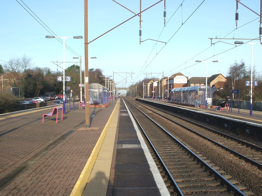
Opened in 1884 by the great
Northern Railway on its line from London to Stevenage. View north towards Stevenage and Peterborough. 11 years later, the platform shelters were replaced and the inevitable railings installed. See
47:
43:
37:
438:– You must give appropriate credit, provide a link to the license, and indicate if changes were made. You may do so in any reasonable manner, but not in any way that suggests the licensor endorses you or your use.
260:
60:
92:
310:
141:
728:
712:
668:
624:
720:
521:
1001:
937:
933:
869:
865:
724:
708:
620:
529:
525:
517:
736:
533:
827:
732:
716:
664:
513:
671:"}},"text\/plain":{"en":{"P275":"Creative Commons Attribution-ShareAlike 2.0 Generic"}}}}": -->
1079:
1074:
536:"}},"text\/plain":{"en":{"P2699":"https:\/\/www.geograph.org.uk\/profile\/84225"}}}}": -->
183:
51:
32:
739:"}},"text\/plain":{"en":{"P973":"https:\/\/www.geograph.org.uk\/photo\/3242098"}}}}": -->
762:
694:
650:
320:
270:
782:
355:
445:
577:
1011:
978:
951:
910:
883:
790:
746:
634:
598:
585:
570:
837:
805:
775:
678:
543:
502:
401:
444:– If you remix, transform, or build upon the material, you must distribute your contributions under the
362:
on the
Geograph website for the photographer's contact details. The copyright on this image is owned by
1111:
627:"}},"text\/plain":{"en":{"P6216":"copyrighted"}}}}": -->
944:"}},"text\/plain":{"en":{"P7787":"337 degree"}}}}": -->
876:"}},"text\/plain":{"en":{"P7787":"337 degree"}}}}": -->
100:
215:
812:
797:
605:
398:
199:
8:
342:
326:
276:
1090:
367:
87:
492:
172:
162:
1021:
961:
893:
847:
756:
688:
644:
553:
347:
359:
1047:
Click on a date/time to view the file as it appeared at that time.
312:
262:
247:
51° 51′ 59.36″ N, 0° 11′ 13.14″ W
125:
Knebworth railway station, Hertfordshire (geograph 3242098).jpg
297:
51° 52′ 01.2″ N, 0° 11′ 14″ W
75:
486:
Add a one-line explanation of what this file represents
142:
TL2420 : Knebworth railway station, Hertfordshire
1105:
1045:
190:
Creative
Commons Attribution Share-alike license 2.0
99:
Commons is a freely licensed media file repository.
695:
Creative
Commons Attribution-ShareAlike 2.0 Generic
669:
Creative
Commons Attribution-ShareAlike 2.0 Generic
65:(1,024 × 768 pixels, file size: 174 KB, MIME type:
144:for a 2021 view from a similar camera position.
455:https://creativecommons.org/licenses/by-sa/2.0
80:
737:https:\/\/www.geograph.org.uk\/photo\/3242098
534:https:\/\/www.geograph.org.uk\/profile\/84225
461:Creative Commons Attribution-Share Alike 2.0
379:
178:
149:
122:
168:
157:
14:
941:
873:
421:– to copy, distribute and transmit the work
813:https://www.geograph.org.uk/photo/3242098
606:https://www.geograph.org.uk/profile/84225
230:Knebworth railway station, Hertfordshire
211:Knebworth railway station, Hertfordshire
136:Knebworth railway station, Hertfordshire
1097:Transferred from geograph.co.uk using
319:View this and other nearby images on:
269:View this and other nearby images on:
222:
111:
366:and is licensed for reuse under the
287:
237:
1107:The following page uses this file:
1038:
402:Attribution-Share Alike 2.0 Generic
390:
385:
370:Attribution-ShareAlike 2.0 license.
13:
491:
485:
376:
353:
129:
112:
58:
1123:
490:
884:coordinates of the point of view
866:coordinates of the point of view
476:
432:Under the following conditions:
397:This file is licensed under the
389:
384:
378:
346:
325:
311:
303:
275:
261:
253:
79:
21:
473:
130:
1042:
763:file available on the internet
713:file available on the internet
472:
354:This image was taken from the
153:Taken on 19 December 2008
26:
1:
952:coordinates of depicted place
934:coordinates of depicted place
899:51°51'59.360"N, 0°11'13.142"W
1102:
783:Geograph Britain and Ireland
721:Geograph Britain and Ireland
571:object of statement has role
518:object of statement has role
498:Items portrayed in this file
338:
302:
252:
7:
228:Nigel Thompson /
209:Nigel Thompson /
10:
1128:
967:51°52'1.16"N, 0°11'13.92"W
446:same or compatible license
119:
114:
1112:Knebworth railway station
1039:
16:
791:geograph.org.uk image ID
725:geograph.org.uk image ID
475:
412:
86:This is a file from the
31:
1096:
200:required by the license
152:
90:. Information from its
360:this photograph's page
331:51.866990; -0.187200
281:51.866489; -0.186984
93:description page there
36:Size of this preview:
427:– to adapt the work
42:Other resolutions:
1075:12:42, 7 July 2017
586:author name string
526:author name string
52:1,024 × 768 pixels
1100:
943:
875:
679:copyright license
665:copyright license
484:
375:
374:
358:collection. See
336:
335:
286:
285:
235:
234:
203:
187:
184:Reusing this file
108:
107:
88:Wikimedia Commons
1119:
1087:
1049:
989:
988:
983:
921:
920:
915:
853:19 December 2008
815:
810:
806:described at URL
800:
795:
785:
780:
733:described at URL
635:copyright status
621:copyright status
608:
603:
593:
590:
580:
575:
482:
468:
465:
462:
459:
456:
448:as the original.
410:
399:Creative Commons
393:
392:
388:
387:
382:
381:
368:Creative Commons
356:Geograph project
350:
343:
332:
329:
315:
314:
308:
307:
306:
300:
299:
288:
282:
279:
265:
264:
258:
257:
256:
250:
249:
238:
197:
181:
134:
126:
120:
104:
83:
82:
76:
70:
68:
55:
48:640 × 480 pixels
44:320 × 240 pixels
38:800 × 600 pixels
1127:
1126:
1122:
1121:
1120:
1118:
1117:
1116:
1101:
1093:
1085:
1041:
1040:
1037:
1036:
1035:
1034:
1033:
1032:
1031:
1030:
1028:
1018:
1017:
1016:
1014:
999:
998:
997:
996:
995:
994:
993:
992:
991:
990:
986:
984:
981:
972:
971:
970:
968:
958:
957:
956:
954:
931:
930:
929:
928:
927:
926:
925:
924:
923:
922:
918:
916:
913:
904:
903:
902:
900:
890:
889:
888:
886:
863:
862:
861:
860:
859:
858:
857:
856:
854:
844:
843:
842:
840:
825:
824:
823:
822:
821:
820:
819:
818:
817:
816:
811:
808:
802:
801:
796:
793:
787:
786:
781:
778:
769:
768:
767:
765:
753:
752:
751:
749:
706:
705:
704:
703:
702:
701:
700:
699:
697:
685:
684:
683:
681:
662:
661:
660:
659:
658:
657:
656:
655:
653:
641:
640:
639:
637:
618:
617:
616:
615:
614:
613:
612:
611:
610:
609:
604:
601:
595:
594:
591:
588:
582:
581:
576:
573:
564:
563:
562:
560:
550:
549:
548:
546:
511:
510:
509:
508:
507:
505:
489:
488:
487:
470:
469:
466:
463:
460:
457:
454:
453:
411:
408:
405:
394:
371:
341:
330:
304:
295:
294:
291:Object location
280:
254:
245:
244:
241:Camera location
236:
225:
218:
206:
163:geograph.org.uk
145:
124:
117:
110:
109:
98:
97:
96:is shown below.
72:
66:
64:
57:
56:
41:
12:
11:
5:
1125:
1115:
1114:
1104:
1099:
1098:
1095:
1091:
1088:
1082:
1077:
1072:
1068:
1067:
1064:
1061:
1058:
1055:
1052:
1044:
1029:
1026:
1024:
1023:
1022:
1020:
1019:
1015:
1010:
1008:
1007:
1006:
1005:
1003:
977:
976:
975:
974:
973:
969:
966:
964:
963:
962:
960:
959:
955:
950:
948:
947:
946:
945:
939:
935:
909:
908:
907:
906:
905:
901:
898:
896:
895:
894:
892:
891:
887:
882:
880:
879:
878:
877:
871:
867:
855:
852:
850:
849:
848:
846:
845:
841:
836:
834:
833:
832:
831:
829:
804:
803:
789:
788:
774:
773:
772:
771:
770:
766:
761:
759:
758:
757:
755:
754:
750:
747:source of file
745:
743:
742:
741:
740:
738:
734:
730:
726:
722:
718:
714:
710:
709:source of file
698:
693:
691:
690:
689:
687:
686:
682:
677:
675:
674:
673:
672:
670:
666:
654:
649:
647:
646:
645:
643:
642:
638:
633:
631:
630:
629:
628:
626:
622:
597:
596:
592:Nigel Thompson
584:
583:
569:
568:
567:
566:
565:
561:
558:
556:
555:
554:
552:
551:
547:
542:
540:
539:
538:
537:
535:
531:
527:
523:
519:
515:
506:
501:
499:
496:
495:
494:
493:
481:
480:
477:
474:
452:
451:
450:
449:
439:
430:
429:
428:
422:
415:You are free:
409:Nigel Thompson
406:
396:
395:
377:
373:
372:
364:Nigel Thompson
351:
340:
337:
334:
333:
323:
317:
292:
284:
283:
273:
267:
242:
233:
232:
226:
223:
220:
219:
214:
207:
204:
192:
191:
188:
176:
175:
173:Nigel Thompson
170:
166:
165:
159:
155:
154:
151:
147:
146:
127:
118:
116:
113:
106:
105:
84:
74:
73:
35:
30:
29:
24:
19:
9:
6:
4:
3:
2:
1124:
1113:
1110:
1109:
1108:
1094:
1089:
1083:
1081:
1078:
1076:
1073:
1070:
1069:
1065:
1062:
1059:
1056:
1053:
1051:
1050:
1048:
1025:
1013:
1009:
980:
965:
953:
949:
912:
897:
885:
881:
851:
839:
835:
814:
807:
799:
792:
784:
777:
764:
760:
748:
744:
696:
692:
680:
676:
652:
648:
636:
632:
607:
600:
587:
579:
572:
557:
545:
541:
504:
500:
497:
478:
471:
458:CC BY-SA 2.0
447:
443:
440:
437:
434:
433:
431:
426:
423:
420:
417:
416:
414:
413:
407:Attribution:
403:
400:
383:
369:
365:
361:
357:
352:
349:
345:
344:
328:
324:
322:
321:OpenStreetMap
318:
316:
298:
293:
290:
289:
278:
274:
272:
271:OpenStreetMap
268:
266:
248:
243:
240:
239:
231:
227:
221:
217:
213: /
212:
208:
201:
196:
194:
193:
189:
185:
180:
177:
174:
171:
167:
164:
160:
156:
148:
143:
138:
137:
133:
128:
121:
102:
95:
94:
89:
85:
78:
77:
71:
62:
61:Original file
53:
49:
45:
39:
34:
28:
25:
23:
20:
18:
15:
1106:
1092:Chris j wood
1084:1,024 × 768
1046:
1043:File history
578:photographer
522:photographer
441:
435:
424:
418:
363:
301:
251:
229:
216:CC BY-SA 2.0
210:
135:
131:
101:You can help
91:
59:
22:File history
651:copyrighted
625:copyrighted
442:share alike
436:attribution
195:Attribution
123:Description
1103:File usage
1060:Dimensions
1027:image/jpeg
1012:media type
1002:media type
559:some value
179:Permission
67:image/jpeg
27:File usage
1057:Thumbnail
1054:Date/Time
838:inception
828:inception
339:Licensing
224:InfoField
205:InfoField
132:English:
1086:(174 KB)
776:operator
717:operator
479:Captions
425:to remix
419:to share
404:license.
1071:current
1066:Comment
979:heading
938:heading
911:heading
870:heading
798:3242098
729:3242098
544:creator
514:creator
503:depicts
483:English
115:Summary
63:
987:degree
942:degree
919:degree
874:degree
309:
259:
169:Author
158:Source
161:From
1063:User
985:337
917:337
467:true
464:true
150:Date
17:File
599:URL
530:URL
982::
914::
809::
794::
779::
602::
589::
574::
50:|
46:|
40:.
202:)
198:(
186:)
182:(
103:.
69:)
54:.
Text is available under the Creative Commons Attribution-ShareAlike License. Additional terms may apply.
.jpg)
.jpg)
.jpg¶ms=051.866489_N_-000.186984_E_globe:Earth_type:camera_heading:337.00_source:geograph&language=en)
.jpg¶ms=051.866990_N_-000.187200_E_globe:Earth_class:object_type:object_source:geograph-osgb36(TL24912026)_region:GB-GBN_heading:337.00&language=en)
