595:"}},"text\/plain":{"en":{"":"inception"}}},"{\"value\":{\"time\":\"+2015-12-14T00:00:00Z\",\"timezone\":0,\"before\":0,\"after\":0,\"precision\":11,\"calendarmodel\":\"http:\\\/\\\/www.wikidata.org\\\/entity\\\/Q1985727\"},\"type\":\"time\"}":{"text\/html":{"en":{"P571":"14 December 2015"}},"text\/plain":{"en":{"P571":"14 December 2015"}}}}": -->
43:
326:
280:
332:
337:
103:
551:"}},"text\/plain":{"en":{"":"copyright license"}}},"{\"value\":{\"entity-type\":\"item\",\"numeric-id\":19068220,\"id\":\"Q19068220\"},\"type\":\"wikibase-entityid\"}":{"text\/html":{"en":{"P275":"
507:"}},"text\/plain":{"en":{"":"copyright status"}}},"{\"value\":{\"entity-type\":\"item\",\"numeric-id\":50423863,\"id\":\"Q50423863\"},\"type\":\"wikibase-entityid\"}":{"text\/html":{"en":{"P6216":"
460:"}},"text\/plain":{"en":{"":"depicts"}}},"{\"value\":{\"entity-type\":\"item\",\"numeric-id\":15848894,\"id\":\"Q15848894\"},\"type\":\"wikibase-entityid\"}":{"text\/html":{"en":{"P180":"
701:
503:
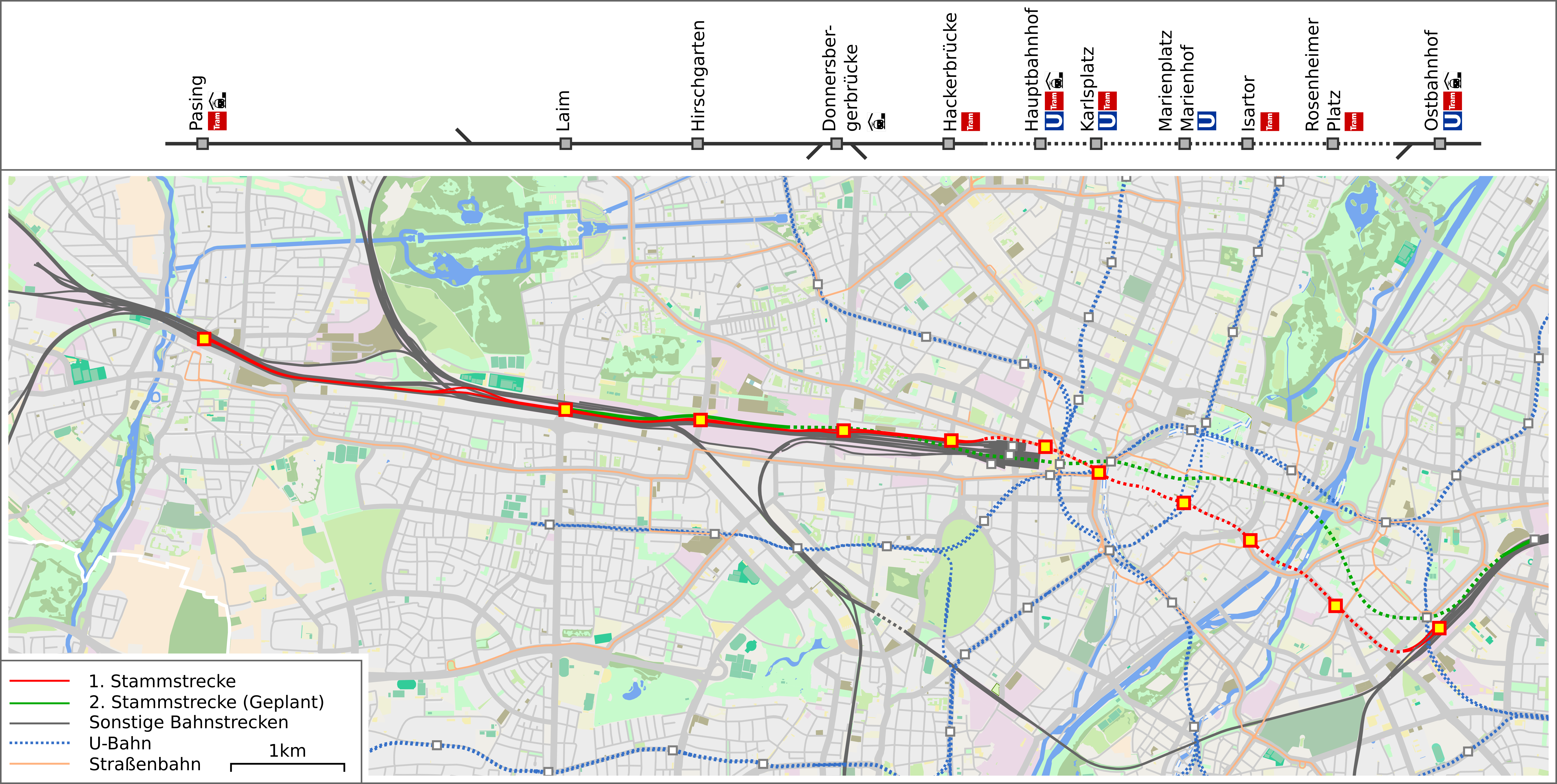
718:{{Information |description={{de|1=Karte der geplanten Ersten Stammstrecke der Münchner S-Bahn}} |date=2015-12-14 |source=OpenStreetMap data exported and adapted by myself |author=*map by OpenStreetMap contributors, All OpenStreetMap data and maps are...
378:– You must give appropriate credit, provide a link to the license, and indicate if changes were made. You may do so in any reasonable manner, but not in any way that suggests the licensor endorses you or your use.
299:
The ODbL does not require any particular license for maps produced from ODbL data. Prior to 1 August 2020, map tiles produced by the OpenStreetMap
Foundation were licensed under the
552:
508:
461:
504:
592:
548:
457:
69:
65:
61:
57:
53:
47:
114:
82:
555:"}},"text\/plain":{"en":{"P275":"Creative Commons Attribution-ShareAlike 2.0 Generic"}}}}": -->
256:
700:
695:
578:
534:
490:
788:
This file contains additional information, probably added from the digital camera or scanner used to create or digitize it.
385:
858:
518:
602:
562:
474:
347:
791:
If the file has been modified from its original state, some details may not fully reflect the modified file.
732:
272:). Map tiles are licensed under the Creative Commons Attribution-ShareAlike 2.0 license (CC-BY-SA 2.0).
384:– If you remix, transform, or build upon the material, you must distribute your contributions under the
670:
665:
73:
42:
511:"}},"text\/plain":{"en":{"P6216":"copyrighted"}}}}": -->
464:"}},"text\/plain":{"en":{"P180":"Stammstrecke"}}}}": -->
688:
Hackerbrücke als
Trambahnhaltestelle deklariert, Donnersbergerbrücke als Regionalzughalt deklariert
122:
344:
217:
This map may be incomplete, and may contain errors. Don't rely solely on it for navigation.
8:
755:
182:
109:
419:
681:
300:
292:
750:
212:
265:
612:
572:
528:
484:
269:
805:
279:
189:
181:
map by OpenStreetMap contributors, All OpenStreetMap data and maps are
711:
274:
638:
Click on a date/time to view the file as it appeared at that time.
303:. Maps produced by other people may be subject to other licences.
288:
235:
765:
161:
97:
450:
Add a one-line explanation of what this file represents
428:
If inappropriate please set warp_status = skip to hide.
775:
87:(7,181 × 3,618 pixels, file size: 6.17 MB, MIME type:
726:
741:
636:
121:
Commons is a freely licensed media file repository.
579:
Creative
Commons Attribution-ShareAlike 2.0 Generic
553:
Creative
Commons Attribution-ShareAlike 2.0 Generic
414:
171:OpenStreetMap data exported and adapted by myself
395:https://creativecommons.org/licenses/by-sa/2.0
102:
401:Creative Commons Attribution-Share Alike 2.0
325:
312:http://opendatacommons.org/licenses/odbl/1.0/
251:
223:
203:
157:
139:
826:xmp.did:16621bdb-585e-460e-9549-7b2eb077a83f
241:
231:
175:
167:
14:
361:– to copy, distribute and transmit the work
264:OpenStreetMap data is available under the
215:project data, collected by the community.
200:
152:Karte der Stammstrecke der Münchner S-Bahn
743:The following other wikis use this file:
756:Knowledge:Kartenwerkstatt/Archiv/2015-12
422:Georeference the map in Wikimaps Warper
206:Karte Erste Stammstrecke Muenchen.png
142:Karte Erste Stammstrecke Muenchen.png
133:
291:, which is made available under the
287:This work contains information from
859:Adobe Photoshop CC 2014 (Macintosh)
728:The following page uses this file:
629:
348:Attribution-Share Alike 2.0 Generic
336:
331:
13:
786:
455:
449:
322:
146:
134:
80:
888:
793:
454:
440:
372:Under the following conditions:
343:This file is licensed under the
335:
330:
324:
278:
101:
31:
21:
839:Date metadata was last modified
437:
823:Unique ID of original document
738:
633:
436:
147:
26:
1:
751:Stammstrecke (S-Bahn München)
420:
36:
733:Stammstrecke (Munich S-Bahn)
723:
470:Items portrayed in this file
293:Open Database License (ODbL)
277:
7:
831:Date and time of digitizing
783:
211:This map was created from
10:
893:
772:Usage on www.wikidata.org
762:Usage on hu.wikipedia.org
747:Usage on de.wikipedia.org
386:same or compatible license
246:OpenStreetMap contributors
136:
847:File change date and time
630:
16:
439:
352:
108:This is a file from the
41:
717:
696:18:54, 14 December 2015
687:
185:"CC-BY-SA 2.0" licensed
160:
112:. Information from its
850:11:58, 30 October 2016
842:11:58, 30 October 2016
834:11:54, 30 October 2016
666:10:06, 30 October 2016
115:description page there
46:Size of this preview:
865:Horizontal resolution
306:Open Database License
266:Open Database License
301:CC-BY-SA-2.0 license
74:7,181 × 3,618 pixels
70:2,560 × 1,290 pixels
873:Vertical resolution
367:– to adapt the work
52:Other resolutions:
227:(see file history)
66:1,280 × 645 pixels
62:1,024 × 516 pixels
880:
879:
739:Global file usage
721:
563:copyright license
549:copyright license
448:
433:
432:
429:
321:
320:
304:
260:
257:Reusing this file
236:openstreetmap.org
218:
197:
196:
130:
129:
110:Wikimedia Commons
32:Global file usage
884:
794:
708:
678:
640:
618:14 December 2015
519:copyright status
505:copyright status
446:
427:
426:
424:
423:
408:
405:
402:
399:
396:
388:as the original.
345:Creative Commons
339:
338:
334:
333:
328:
327:
316:
313:
310:
307:
298:
282:
275:
254:
216:
207:
201:
183:Creative Commons
163:
162:14 December 2015
151:
143:
137:
126:
105:
104:
98:
92:
90:
77:
58:640 × 322 pixels
54:320 × 161 pixels
48:800 × 403 pixels
892:
891:
887:
886:
885:
883:
882:
881:
782:
737:
722:
714:
706:
684:
676:
632:
631:
628:
627:
626:
625:
624:
623:
622:
621:
619:
609:
608:
607:
605:
590:
589:
588:
587:
586:
585:
584:
583:
581:
569:
568:
567:
565:
546:
545:
544:
543:
542:
541:
540:
539:
537:
525:
524:
523:
521:
502:
501:
500:
499:
498:
497:
496:
495:
493:
481:
480:
479:
477:
453:
452:
451:
434:
421:
418:
410:
409:
406:
403:
400:
397:
394:
393:
351:
340:
314:
311:
308:
305:
247:
219:
205:
198:
153:
141:
132:
131:
120:
119:
118:is shown below.
94:
88:
86:
79:
78:
51:
12:
11:
5:
890:
878:
877:
874:
870:
869:
866:
862:
861:
856:
852:
851:
848:
844:
843:
840:
836:
835:
832:
828:
827:
824:
820:
819:
816:
812:
811:
808:
802:
801:
798:
785:
781:
780:
779:
778:
770:
769:
768:
760:
759:
758:
753:
740:
736:
735:
725:
720:
719:
716:
712:
709:
705:7,181 × 3,618
703:
698:
693:
690:
689:
686:
682:
679:
675:7,181 × 3,618
673:
668:
663:
659:
658:
655:
652:
649:
646:
643:
635:
620:
617:
615:
614:
613:
611:
610:
606:
601:
599:
598:
597:
596:
594:
582:
577:
575:
574:
573:
571:
570:
566:
561:
559:
558:
557:
556:
554:
550:
538:
533:
531:
530:
529:
527:
526:
522:
517:
515:
514:
513:
512:
510:
506:
494:
489:
487:
486:
485:
483:
482:
478:
473:
471:
468:
467:
466:
465:
463:
459:
445:
444:
441:
438:
431:
430:
416:
415:Georeferencing
412:
411:
392:
391:
390:
389:
379:
370:
369:
368:
362:
355:You are free:
342:
341:
323:
319:
318:
285:
283:
261:
249:
248:
245:
243:
239:
238:
233:
229:
228:
225:
221:
220:
210:
208:
199:
195:
194:
193:
192:
186:
177:
173:
172:
169:
165:
164:
159:
155:
154:
144:
135:
128:
127:
106:
96:
95:
45:
40:
39:
34:
29:
24:
19:
9:
6:
4:
3:
2:
889:
875:
872:
871:
867:
864:
863:
860:
857:
855:Software used
854:
853:
849:
846:
845:
841:
838:
837:
833:
830:
829:
825:
822:
821:
817:
814:
813:
809:
807:
804:
803:
799:
796:
795:
792:
789:
777:
774:
773:
771:
767:
764:
763:
761:
757:
754:
752:
749:
748:
746:
745:
744:
734:
731:
730:
729:
715:
710:
704:
702:
699:
697:
694:
692:
691:
685:
680:
674:
672:
669:
667:
664:
661:
660:
656:
653:
650:
647:
644:
642:
641:
639:
616:
604:
600:
580:
576:
564:
560:
536:
532:
520:
516:
492:
488:
476:
472:
469:
442:
435:
425:
417:
413:
398:CC BY-SA 2.0
387:
383:
380:
377:
374:
373:
371:
366:
363:
360:
357:
356:
354:
353:
349:
346:
329:
317:
302:
296:
294:
290:
289:OpenStreetMap
286:
284:
281:
276:
273:
271:
267:
262:
258:
253:
250:
244:
240:
237:
234:
230:
226:
222:
214:
213:OpenStreetMap
209:
202:
191:
187:
184:
180:
179:
178:
174:
170:
166:
156:
150:
145:
138:
124:
117:
116:
111:
107:
100:
99:
93:
84:
83:Original file
75:
71:
67:
63:
59:
55:
49:
44:
38:
35:
33:
30:
28:
25:
23:
20:
18:
15:
815:Image height
810:Uncalibrated
790:
787:
766:Stammstrecke
742:
727:
637:
634:File history
491:Stammstrecke
462:Stammstrecke
381:
375:
364:
358:
297:
263:
148:
123:You can help
113:
81:
22:File history
806:Color space
797:Image width
683:Drlellinger
535:copyrighted
509:copyrighted
382:share alike
376:attribution
204:Description
188:adapted by
140:Description
876:284.65 dpi
868:284.65 dpi
724:File usage
651:Dimensions
252:Permission
27:File usage
776:Q15848894
707:(5.23 MB)
677:(6.17 MB)
648:Thumbnail
645:Date/Time
603:inception
593:inception
149:Deutsch:
89:image/png
818:3,618 px
800:7,181 px
784:Metadata
443:Captions
365:to remix
359:to share
350:license.
37:Metadata
662:current
657:Comment
475:depicts
458:depicts
447:English
270:details
242:Creator
85:
232:Source
176:Author
168:Source
713:Vuxi
654:User
407:true
404:true
315:true
309:ODbL
224:Date
190:vuxi
158:Date
17:File
295:.
72:|
68:|
64:|
60:|
56:|
50:.
268:(
259:)
255:(
125:.
91:)
76:.
Text is available under the Creative Commons Attribution-ShareAlike License. Additional terms may apply.