572:"}},"text\/plain":{"en":{"":"coordinates of the point of view"}}},"{\"value\":{\"latitude\":56.271229,\"longitude\":-4.926247,\"altitude\":null,\"precision\":1.0e-6,\"globe\":\"http:\\\/\\\/www.wikidata.org\\\/entity\\\/Q2\"},\"type\":\"globecoordinate\"}":{"text\/html":{"en":{"P1259":"56\u00b016'16.424"N, 4\u00b055'34.489"W"}},"text\/plain":{"en":{"P1259":"56\u00b016'16.424\"N, 4\u00b055'34.489\"W"}}},"{\"value\":{\"entity-type\":\"property\",\"numeric-id\":7787,\"id\":\"P7787\"},\"type\":\"wikibase-entityid\"}":{"text\/html":{"en":{"":"
640:"}},"text\/plain":{"en":{"":"coordinates of depicted place"}}},"{\"value\":{\"latitude\":56.2717,\"longitude\":-4.927,\"altitude\":null,\"precision\":0.0001,\"globe\":\"http:\\\/\\\/www.wikidata.org\\\/entity\\\/Q2\"},\"type\":\"globecoordinate\"}":{"text\/html":{"en":{"P9149":"56\u00b016'18.1"N, 4\u00b055'37.2"W"}},"text\/plain":{"en":{"P9149":"56\u00b016'18.1\"N, 4\u00b055'37.2\"W"}}},"{\"value\":{\"entity-type\":\"property\",\"numeric-id\":7787,\"id\":\"P7787\"},\"type\":\"wikibase-entityid\"}":{"text\/html":{"en":{"":"
534:"}},"text\/plain":{"en":{"":"inception"}}},"{\"value\":{\"time\":\"+2006-10-16T00:00:00Z\",\"timezone\":0,\"before\":0,\"after\":0,\"precision\":11,\"calendarmodel\":\"http:\\\/\\\/www.wikidata.org\\\/entity\\\/Q1985727\"},\"type\":\"time\"}":{"text\/html":{"en":{"P571":"16 October 2006"}},"text\/plain":{"en":{"P571":"16 October 2006"}}}}": -->
310:
175:
125:
636:
117:
189:
139:
278:
316:
321:
67:
490:"}},"text\/plain":{"en":{"":"copyright license"}}},"{\"value\":{\"entity-type\":\"item\",\"numeric-id\":19068220,\"id\":\"Q19068220\"},\"type\":\"wikibase-entityid\"}":{"text\/html":{"en":{"P275":"
446:"}},"text\/plain":{"en":{"":"copyright status"}}},"{\"value\":{\"entity-type\":\"item\",\"numeric-id\":50423863,\"id\":\"Q50423863\"},\"type\":\"wikibase-entityid\"}":{"text\/html":{"en":{"P6216":"
644:"}},"text\/plain":{"en":{"":"heading"}}},"{\"value\":{\"amount\":\"+270\",\"unit\":\"http:\\\/\\\/www.wikidata.org\\\/entity\\\/Q28390\"},\"type\":\"quantity\"}":{"text\/html":{"en":{"P7787":"270
576:"}},"text\/plain":{"en":{"":"heading"}}},"{\"value\":{\"amount\":\"+270\",\"unit\":\"http:\\\/\\\/www.wikidata.org\\\/entity\\\/Q28390\"},\"type\":\"quantity\"}":{"text\/html":{"en":{"P7787":"270
442:
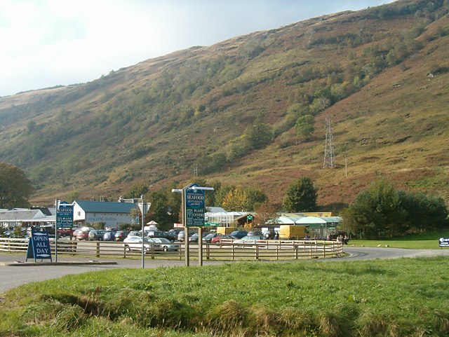
763:==Summary== {{Information| |Description = The Loch Fyne Oyster Bar at Cairndow in Scotland. This was the precursor of the chain of Loch Fyne restaurants that now exist throughout the UK. For more information see the Knowledge article ''[[w:en:Loch Fyne Oy
158:
38:
108:
368:– You must give appropriate credit, provide a link to the license, and indicate if changes were made. You may do so in any reasonable manner, but not in any way that suggests the licensor endorses you or your use.
122:
172:
215:
The Loch Fyne Oyster Bar at
Cairndow in Scotland. This was the precursor of the chain of Loch Fyne restaurants that now exist throughout the UK. For more information see the Knowledge article
491:
447:
641:
637:
573:
569:
443:
531:
487:
78:
46:
494:"}},"text\/plain":{"en":{"P275":"Creative Commons Attribution-ShareAlike 2.0 Generic"}}}}": -->
254:
517:
473:
182:
132:
285:
217:
375:
682:
655:
614:
587:
457:
541:
501:
432:
331:
374:– If you remix, transform, or build upon the material, you must distribute your contributions under the
292:
on the
Geograph website for the photographer's contact details. The copyright on this image is owned by
745:
740:
37:
450:"}},"text\/plain":{"en":{"P6216":"copyrighted"}}}}": -->
648:"}},"text\/plain":{"en":{"P7787":"270 degree"}}}}": -->
580:"}},"text\/plain":{"en":{"P7787":"270 degree"}}}}": -->
86:
328:
8:
272:
188:
138:
777:
756:
297:
73:
422:
665:
597:
551:
511:
467:
277:
289:
713:
Click on a date/time to view the file as it appeared at that time.
174:
124:
109:
56° 16′ 16.42″ N, 4° 55′ 34.49″ W
795:
261:
Published under
Creative Commons Attribution-Sharealike 2.0.
159:
56° 16′ 18″ N, 4° 55′ 37″ W
61:
416:
Add a one-line explanation of what this file represents
771:
786:
711:
85:
Commons is a freely licensed media file repository.
518:
Creative
Commons Attribution-ShareAlike 2.0 Generic
492:
Creative
Commons Attribution-ShareAlike 2.0 Generic
51:(640 × 481 pixels, file size: 95 KB, MIME type:
385:https://creativecommons.org/licenses/by-sa/2.0
66:
391:Creative Commons Attribution-Share Alike 2.0
309:
249:
225:
208:
241:
233:
14:
645:
577:
351:– to copy, distribute and transmit the work
788:The following other wikis use this file:
181:View this and other nearby images on:
131:View this and other nearby images on:
97:
296:and is licensed for reuse under the
149:
99:
773:The following page uses this file:
704:
332:Attribution-Share Alike 2.0 Generic
320:
315:
300:Attribution-ShareAlike 2.0 license.
13:
421:
415:
306:
283:
211:Loch Fyne Oyster Bar, Cairndow.jpg
98:
47:Loch_Fyne_Oyster_Bar,_Cairndow.jpg
44:
809:
420:
218:Loch Fyne Oysters and Restaurants
588:coordinates of the point of view
570:coordinates of the point of view
406:
362:Under the following conditions:
327:This file is licensed under the
319:
314:
308:
276:
187:
173:
165:
137:
123:
115:
65:
31:
21:
403:
41:No higher resolution available.
783:
708:
402:
284:This image was taken from the
26:
1:
656:coordinates of depicted place
638:coordinates of depicted place
603:56°16'16.424"N, 4°55'34.489"W
229:Taken on 16 October 2006
768:
428:Items portrayed in this file
268:
164:
114:
7:
10:
814:
792:Usage on de.wikipedia.org
376:same or compatible license
205:
200:
705:
671:56°16'18.1"N, 4°55'37.2"W
16:
405:
342:
72:This is a file from the
36:
762:
741:12:08, 13 February 2008
228:
76:. Information from its
290:this photograph's page
193:56.271700; -4.927000
143:56.271229; -4.926247
79:description page there
237:www.geograph.org.uk.
357:– to adapt the work
796:Loch Fyne Oysters
784:Global file usage
778:Loch Fyne Oysters
766:
647:
579:
502:copyright license
488:copyright license
414:
305:
304:
288:collection. See
265:
264:
258:
255:Reusing this file
198:
197:
148:
147:
94:
93:
74:Wikimedia Commons
32:Global file usage
805:
753:
715:
693:
692:
687:
625:
624:
619:
458:copyright status
444:copyright status
412:
398:
395:
392:
389:
386:
378:as the original.
340:
329:Creative Commons
323:
322:
318:
317:
312:
311:
298:Creative Commons
286:Geograph project
280:
273:
252:
212:
206:
194:
191:
177:
176:
170:
169:
168:
162:
161:
150:
144:
141:
127:
126:
120:
119:
118:
112:
111:
100:
90:
69:
68:
62:
56:
54:
813:
812:
808:
807:
806:
804:
803:
802:
782:
767:
759:
751:
707:
706:
703:
702:
701:
700:
699:
698:
697:
696:
695:
694:
690:
688:
685:
676:
675:
674:
672:
662:
661:
660:
658:
635:
634:
633:
632:
631:
630:
629:
628:
627:
626:
622:
620:
617:
608:
607:
606:
604:
594:
593:
592:
590:
567:
566:
565:
564:
563:
562:
561:
560:
558:
557:16 October 2006
548:
547:
546:
544:
529:
528:
527:
526:
525:
524:
523:
522:
520:
508:
507:
506:
504:
485:
484:
483:
482:
481:
480:
479:
478:
476:
464:
463:
462:
460:
441:
440:
439:
438:
437:
435:
419:
418:
417:
400:
399:
396:
393:
390:
387:
384:
383:
341:
338:
335:
324:
301:
271:
266:
245:Patrick Mackie.
210:
203:
192:
166:
157:
156:
153:Object location
142:
116:
107:
106:
103:Camera location
96:
95:
84:
83:
82:is shown below.
58:
52:
50:
43:
42:
12:
11:
5:
811:
801:
800:
799:
798:
785:
781:
780:
770:
765:
764:
761:
757:
754:
748:
743:
738:
734:
733:
730:
727:
724:
721:
718:
710:
681:
680:
679:
678:
677:
673:
670:
668:
667:
666:
664:
663:
659:
654:
652:
651:
650:
649:
643:
639:
613:
612:
611:
610:
609:
605:
602:
600:
599:
598:
596:
595:
591:
586:
584:
583:
582:
581:
575:
571:
559:
556:
554:
553:
552:
550:
549:
545:
540:
538:
537:
536:
535:
533:
521:
516:
514:
513:
512:
510:
509:
505:
500:
498:
497:
496:
495:
493:
489:
477:
472:
470:
469:
468:
466:
465:
461:
456:
454:
453:
452:
451:
449:
445:
436:
431:
429:
426:
425:
424:
423:
411:
410:
407:
404:
382:
381:
380:
379:
369:
360:
359:
358:
352:
345:You are free:
339:Patrick Mackie
336:
326:
325:
307:
303:
302:
294:Patrick Mackie
281:
270:
267:
263:
262:
259:
247:
246:
243:
239:
238:
235:
231:
230:
227:
223:
222:
213:
204:
202:
199:
196:
195:
185:
179:
154:
146:
145:
135:
129:
104:
92:
91:
70:
60:
59:
40:
35:
34:
29:
24:
19:
9:
6:
4:
3:
2:
810:
797:
794:
793:
791:
790:
789:
779:
776:
775:
774:
760:
755:
749:
747:
744:
742:
739:
736:
735:
731:
728:
725:
722:
719:
717:
716:
714:
684:
669:
657:
653:
616:
601:
589:
585:
555:
543:
539:
519:
515:
503:
499:
475:
471:
459:
455:
434:
430:
427:
408:
401:
388:CC BY-SA 2.0
377:
373:
370:
367:
364:
363:
361:
356:
353:
350:
347:
346:
344:
343:
337:Attribution:
333:
330:
313:
299:
295:
291:
287:
282:
279:
275:
274:
260:
256:
251:
248:
244:
240:
236:
232:
224:
220:
219:
214:
207:
190:
186:
184:
183:OpenStreetMap
180:
178:
160:
155:
152:
151:
140:
136:
134:
133:OpenStreetMap
130:
128:
110:
105:
102:
101:
88:
81:
80:
75:
71:
64:
63:
57:
48:
39:
33:
30:
28:
25:
23:
20:
18:
15:
787:
772:
758:Chris j wood
712:
709:File history
371:
365:
354:
348:
293:
216:
163:
113:
87:You can help
77:
45:
22:File history
474:copyrighted
448:copyrighted
372:share alike
366:attribution
209:Description
769:File usage
750:640 × 481
726:Dimensions
250:Permission
53:image/jpeg
27:File usage
723:Thumbnail
720:Date/Time
542:inception
532:inception
269:Licensing
409:Captions
355:to remix
349:to share
334:license.
752:(95 KB)
737:current
732:Comment
683:heading
642:heading
615:heading
574:heading
433:depicts
413:English
201:Summary
49:
691:degree
646:degree
623:degree
578:degree
242:Author
234:Source
171:
121:
729:User
689:270
621:270
397:true
394:true
226:Date
17:File
686::
618::
257:)
253:(
221:.
89:.
55:)
_region:GB-SCT_heading:270.00&language=en)
