820:
377:
20:
418:
28:
72:. It is flanked by four smaller uninhabited islands - one to the east (Layeni), one to the west (Nus Leur) and two to the south (Terbang Utari and Terbang Selatan). Together they are called the Damar Islands, and constitute one administrative district within the
163:. There are seven villages on the island - Batumerah on the northwest coast (which has the postcode of 97128), and Wulur, Kuay Melu, Kumur, Bebar Timur, Ilih and Keyli in the east (which share the postcode 97652).
152:, while the southern part is still mainly forested. Habitation is concentrated in the north and east; most islanders are farmers or fishers. The highest point of the island is 868 m (2,847 ft)
104:
and are uninhabited. The district has a combined land area of 201.80 km and had a population of 5,718 at the 2020 Census; the official estimate as at mid 2023 was 6,362, all on Damer Island itself.
80:. Continuing the line of the ridge further to the northeast are several small and remote islands at increasing distances from Damer Island; these are
895:
885:
861:
544:
781:
890:
112:
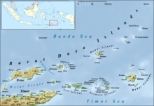
Damar is about 20 km (12 mi.) long by 18 km (11 mi.) wide. It lies about 125 km (78 mi.) east of
368:, includes the small islands of Terbang Utari and Terbang Selatan. (b) comprising 3,127 males and 2,896 females.
854:
175:), listed below with their officially-estimated populations as at mid 2022, together with their postcodes.
537:
65:
880:
460:
847:
530:
497:
388:
381:
93:
489:
762:
604:
92:(and its offshore islet of Kekeh-Besar) and - far to the north and administered as part of
77:
8:
642:
392:
43:
672:
57:
835:
624:
73:
76:
Regency, lying on the undersea ridge which forms the most easterly extension of the
752:
399:
827:
757:
732:
125:
113:
831:
553:
516:
Badan Pusat
Statistik, 2023, Kecamatan Damer, Katalog/Catalog: 1102001.8108050.
423:
874:
796:
783:
677:
662:
657:
569:
160:
153:
121:
101:
742:
717:
697:
637:
561:
747:
682:
599:
584:
137:
97:
89:
376:
19:
722:
141:
85:
81:
819:
727:
574:
403:
69:
61:
396:
157:
27:
737:
632:
609:
594:
522:
417:
129:
53:
707:
687:
614:
589:
149:
133:
767:
712:
702:
692:
647:
579:
145:
117:
171:
The island is administratively divided into seven villages (
652:
468:
387:
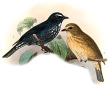
The forested part of the island has been identified by
413:
120:. The northern part of the island has been largely
872:
467:. BirdLife International. 2014. Archived from
100:; all of these far-flung islands are isolated
855:
538:
862:
848:
545:
531:
402:, which is largely restricted to lowland
375:
52:), also called Kenli Island, is a small
26:
18:
380:Damar flycatcher; 1901 illustration by
116:and 200 km (124 mi.) east of
873:
371:
68:province, on the southern side of the
526:
455:
453:
447:Badan Pusat Statistik, Jakarta, 2024.
438:Badan Pusat Statistik, Jakarta, 2021.
814:
13:
552:
450:
14:
907:
896:Maluku (province) geography stubs
886:Important Bird Areas of Indonesia
826:This article about a location in
818:
416:
88:, tiny 'Nil Desperandum' islet,
510:
482:
465:Important Bird Areas factsheet
441:
432:
107:
1:
891:Populated places in Indonesia
409:
364:Notes: (a) the most southern
23:Map of the Barat Daya Islands
834:. You can help Knowledge by
7:
351:
344:
324:
321:
307:
304:
290:
287:
273:
270:
256:
253:
239:
236:
222:
219:
166:
16:Island in Maluku, Indonesia
10:
912:
813:
623:
560:
494:Global Volcanism Program
395:because it supports the
498:Smithsonian Institution
389:BirdLife International
384:
382:John Gerrard Keulemans
47:
32:
24:
797:7.14167°S 128.61250°E
379:
94:Maluku Tengah Regency
30:
22:
78:Lesser Sunda Islands
802:-7.14167; 128.61250
793: /
393:Important Bird Area
372:Important Bird Area
881:Barat Daya Islands
385:
58:Barat Daya Islands
33:
25:
843:
842:
776:
775:
362:
361:
74:Maluku Barat Daya
903:
864:
857:
850:
822:
815:
808:
807:
805:
804:
803:
798:
794:
791:
790:
789:
786:
547:
540:
533:
524:
523:
517:
514:
508:
507:
505:
504:
486:
480:
479:
477:
476:
471:on July 10, 2007
457:
448:
445:
439:
436:
426:
421:
420:
406:forest habitat.
400:Damar flycatcher
178:
177:
911:
910:
906:
905:
904:
902:
901:
900:
871:
870:
869:
868:
828:Maluku Province
811:
801:
799:
795:
792:
787:
784:
782:
780:
779:
777:
772:
625:Maluku province
619:
556:
551:
521:
520:
515:
511:
502:
500:
488:
487:
483:
474:
472:
459:
458:
451:
446:
442:
437:
433:
422:
415:
412:
374:
208:
203:
201:
196:
194:
187:
182:
169:
126:dryland farming
110:
102:stratovolcanoes
17:
12:
11:
5:
909:
899:
898:
893:
888:
883:
867:
866:
859:
852:
844:
841:
840:
823:
774:
773:
771:
770:
765:
760:
755:
750:
745:
740:
735:
730:
725:
720:
715:
710:
705:
700:
695:
690:
685:
680:
675:
670:
665:
660:
655:
650:
645:
640:
635:
629:
627:
621:
620:
618:
617:
612:
607:
602:
597:
592:
587:
582:
577:
572:
566:
564:
558:
557:
554:Maluku Islands
550:
549:
542:
535:
527:
519:
518:
509:
481:
449:
440:
430:
429:
428:
427:
424:Islands portal
411:
408:
373:
370:
360:
359:
357:
350:
343:
336:
330:
329:
326:
323:
320:
317:
313:
312:
309:
306:
303:
300:
296:
295:
292:
289:
286:
283:
279:
278:
275:
272:
269:
266:
262:
261:
258:
255:
252:
249:
245:
244:
241:
238:
235:
232:
228:
227:
224:
221:
218:
215:
211:
210:
205:
198:
191:
184:
168:
165:
109:
106:
56:island in the
15:
9:
6:
4:
3:
2:
908:
897:
894:
892:
889:
887:
884:
882:
879:
878:
876:
865:
860:
858:
853:
851:
846:
845:
839:
837:
833:
829:
824:
821:
817:
816:
812:
809:
806:
769:
766:
764:
761:
759:
756:
754:
751:
749:
746:
744:
741:
739:
736:
734:
731:
729:
726:
724:
721:
719:
716:
714:
711:
709:
706:
704:
701:
699:
696:
694:
691:
689:
686:
684:
681:
679:
676:
674:
671:
669:
666:
664:
661:
659:
656:
654:
651:
649:
646:
644:
641:
639:
636:
634:
631:
630:
628:
626:
622:
616:
613:
611:
608:
606:
603:
601:
598:
596:
593:
591:
588:
586:
583:
581:
578:
576:
573:
571:
568:
567:
565:
563:
559:
555:
548:
543:
541:
536:
534:
529:
528:
525:
513:
499:
495:
491:
485:
470:
466:
462:
461:"Pulau Damar"
456:
454:
444:
435:
431:
425:
419:
414:
407:
405:
401:
398:
394:
390:
383:
378:
369:
367:
358:
356:
355:
349:
348:
342:
341:
337:
335:
332:
331:
327:
318:
316:81.08.02.2007
315:
314:
310:
301:
299:81.08.02.2006
298:
297:
293:
284:
282:81.08.02.2005
281:
280:
276:
267:
265:81.08.02.2004
264:
263:
259:
250:
248:81.08.02.2003
247:
246:
242:
233:
231:81.08.02.2002
230:
229:
225:
216:
214:81.08.02.2001
213:
212:
206:
199:
192:
190:
185:
180:
179:
176:
174:
164:
162:
161:stratovolcano
159:
155:
154:Mount Wurlali
151:
147:
143:
139:
135:
131:
127:
123:
119:
115:
105:
103:
99:
95:
91:
87:
83:
79:
75:
71:
67:
63:
59:
55:
51:
50:
45:
41:
37:
31:Mount Wurlali
29:
21:
836:expanding it
825:
810:
778:
667:
562:North Maluku
512:
501:. Retrieved
493:
484:
473:. Retrieved
469:the original
464:
443:
434:
386:
365:
363:
353:
352:
346:
345:
339:
338:
333:
188:
172:
170:
138:coffee beans
111:
98:Manuk Island
90:Serua Island
48:
39:
35:
34:
800: /
788:128°36′45″E
285:Bebar Timur
142:cocoa beans
108:Description
86:Nila Island
82:Teon Island
49:Pulau Damer
875:Categories
785:07°08′30″S
503:2014-03-12
475:2014-03-12
410:References
200:Population
44:Indonesian
728:Nusa Laut
575:Halmahera
490:"Wurlali"
404:evergreen
251:Kuay Melu
234:Batumerah
158:andesitic
70:Banda Sea
62:Indonesia
60:group in
763:Watubela
753:Tanimbar
334:81.08.02
204:estimate
202:mid 2022
186:Name of
167:Villages
130:coconuts
54:volcanic
758:Tayandu
738:Saparua
633:Ambelau
610:Ternate
595:Morotai
397:endemic
183:Wilayah
150:nutmegs
134:cashews
122:cleared
733:Romang
708:Manipa
688:Kelang
678:Haruku
673:Gorong
615:Tidore
590:Makian
391:as an
347:392.29
340:Totals
328:97652
311:97652
294:97652
277:97652
260:97652
243:97128
226:97652
220:137.50
217:Wulur
146:cloves
114:Romang
66:Maluku
830:is a
768:Wetar
748:Serua
743:Seram
713:Manuk
703:Liran
693:Kisar
668:Damar
663:Banda
658:Babar
648:Boano
638:Ambon
580:Kayoa
570:Bacan
354:6,023
325:1,088
322:18.15
319:Kehli
305:15.75
291:1,005
288:47.53
271:28.25
268:Kumur
254:56.31
237:88.80
223:1,675
209:code
193:Area
181:Kode
156:, an
118:Wetar
40:Damar
38:, or
36:Damer
832:stub
723:Nila
698:Leti
653:Buru
605:Sula
585:Moti
366:desa
302:Ilih
207:Post
189:desa
173:desa
148:and
124:for
718:Moa
683:Kai
643:Aru
600:Obi
308:591
274:519
257:338
240:807
195:in
128:of
64:'s
42:, (
877::
496:.
492:.
463:.
452:^
197:km
144:,
140:,
136:,
132:,
96:-
84:,
46::
863:e
856:t
849:v
838:.
546:e
539:t
532:v
506:.
478:.
Text is available under the Creative Commons Attribution-ShareAlike License. Additional terms may apply.


