680:"}},"text\/plain":{"en":{"":"coordinates of the point of view"}}},"{\"value\":{\"latitude\":51.54875,\"longitude\":0.5974,\"altitude\":null,\"precision\":1.0e-5,\"globe\":\"http:\\\/\\\/www.wikidata.org\\\/entity\\\/Q2\"},\"type\":\"globecoordinate\"}":{"text\/html":{"en":{"P1259":"51\u00b032'55.50"N, 0\u00b035'50.64"E"}},"text\/plain":{"en":{"P1259":"51\u00b032'55.50\"N, 0\u00b035'50.64\"E"}}},"{\"value\":{\"entity-type\":\"property\",\"numeric-id\":7787,\"id\":\"P7787\"},\"type\":\"wikibase-entityid\"}":{"text\/html":{"en":{"":"
905:"}},"text\/plain":{"en":{"":"coordinates of depicted place"}}},"{\"value\":{\"latitude\":51.55317,\"longitude\":0.6091,\"altitude\":null,\"precision\":1.0e-5,\"globe\":\"http:\\\/\\\/www.wikidata.org\\\/entity\\\/Q2\"},\"type\":\"globecoordinate\"}":{"text\/html":{"en":{"P9149":"51\u00b033'11.41"N, 0\u00b036'32.76"E"}},"text\/plain":{"en":{"P9149":"51\u00b033'11.41\"N, 0\u00b036'32.76\"E"}}},"{\"value\":{\"entity-type\":\"property\",\"numeric-id\":7787,\"id\":\"P7787\"},\"type\":\"wikibase-entityid\"}":{"text\/html":{"en":{"":"
1011:"}},"text\/plain":{"en":{"":"checksum"}}},"{\"value\":\"168d5dafc65e052f7b6186f63b0df7966af5cd0f\",\"type\":\"string\"}":{"text\/html":{"en":{"P4092":"168d5dafc65e052f7b6186f63b0df7966af5cd0f"}},"text\/plain":{"en":{"P4092":"168d5dafc65e052f7b6186f63b0df7966af5cd0f"}}},"{\"value\":{\"entity-type\":\"property\",\"numeric-id\":459,\"id\":\"P459\"},\"type\":\"wikibase-entityid\"}":{"text\/html":{"en":{"":"
497:"}},"text\/plain":{"en":{"":"author name string"}}},"{\"value\":\"Edward Clack\",\"type\":\"string\"}":{"text\/html":{"en":{"P2093":"Edward Clack"}},"text\/plain":{"en":{"P2093":"Edward Clack"}}},"{\"value\":{\"entity-type\":\"property\",\"numeric-id\":2699,\"id\":\"P2699\"},\"type\":\"wikibase-entityid\"}":{"text\/html":{"en":{"":"
867:"}},"text\/plain":{"en":{"":"inception"}}},"{\"value\":{\"time\":\"+1991-02-01T00:00:00Z\",\"timezone\":0,\"before\":0,\"after\":0,\"precision\":10,\"calendarmodel\":\"http:\\\/\\\/www.wikidata.org\\\/entity\\\/Q1985727\"},\"type\":\"time\"}":{"text\/html":{"en":{"P571":"February 1991"}},"text\/plain":{"en":{"P571":"February 1991"}}}}": -->
744:
282:
232:
1007:
224:
296:
246:
317:
355:
360:
72:
1251:
752:"}},"text\/plain":{"en":{"P7482":"file available on the internet"}}},"{\"value\":{\"entity-type\":\"property\",\"numeric-id\":137,\"id\":\"P137\"},\"type\":\"wikibase-entityid\"}":{"text\/html":{"en":{"":"
760:"}},"text\/plain":{"en":{"P137":"Geograph Britain and Ireland"}}},"{\"value\":{\"entity-type\":\"property\",\"numeric-id\":7384,\"id\":\"P7384\"},\"type\":\"wikibase-entityid\"}":{"text\/html":{"en":{"":"
489:"}},"text\/plain":{"en":{"":"object of statement has role"}}},"{\"value\":{\"entity-type\":\"item\",\"numeric-id\":33231,\"id\":\"Q33231\"},\"type\":\"wikibase-entityid\"}":{"text\/html":{"en":{"P3831":"
1015:"}},"text\/plain":{"en":{"":"determination method"}}},"{\"value\":{\"entity-type\":\"item\",\"numeric-id\":13414952,\"id\":\"Q13414952\"},\"type\":\"wikibase-entityid\"}":{"text\/html":{"en":{"P459":"
973:"}},"text\/plain":{"en":{"":"media type"}}},"{\"value\":\"image\\\/jpeg\",\"type\":\"string\"}":{"text\/html":{"en":{"P1163":"image\/jpeg"}},"text\/plain":{"en":{"P1163":"image\/jpeg"}}}}": -->
636:"}},"text\/plain":{"en":{"":"copyright license"}}},"{\"value\":{\"entity-type\":\"item\",\"numeric-id\":19068220,\"id\":\"Q19068220\"},\"type\":\"wikibase-entityid\"}":{"text\/html":{"en":{"P275":"
592:"}},"text\/plain":{"en":{"":"copyright status"}}},"{\"value\":{\"entity-type\":\"item\",\"numeric-id\":50423863,\"id\":\"Q50423863\"},\"type\":\"wikibase-entityid\"}":{"text\/html":{"en":{"P6216":"
748:"}},"text\/plain":{"en":{"":"source of file"}}},"{\"value\":{\"entity-type\":\"item\",\"numeric-id\":74228490,\"id\":\"Q74228490\"},\"type\":\"wikibase-entityid\"}":{"text\/html":{"en":{"P7482":"
1078:"}},"text\/plain":{"en":{"":"data size"}}},"{\"value\":{\"amount\":\"+308647\",\"unit\":\"http:\\\/\\\/www.wikidata.org\\\/entity\\\/Q8799\"},\"type\":\"quantity\"}":{"text\/html":{"en":{"P3575":"308,647
493:"}},"text\/plain":{"en":{"P3831":"photographer"}}},"{\"value\":{\"entity-type\":\"property\",\"numeric-id\":2093,\"id\":\"P2093\"},\"type\":\"wikibase-entityid\"}":{"text\/html":{"en":{"":"
1123:"}},"text\/plain":{"en":{"":"height"}}},"{\"value\":{\"amount\":\"+503\",\"unit\":\"http:\\\/\\\/www.wikidata.org\\\/entity\\\/Q355198\"},\"type\":\"quantity\"}":{"text\/html":{"en":{"P2048":"503
756:"}},"text\/plain":{"en":{"":"operator"}}},"{\"value\":{\"entity-type\":\"item\",\"numeric-id\":1503119,\"id\":\"Q1503119\"},\"type\":\"wikibase-entityid\"}":{"text\/html":{"en":{"P137":"
1168:"}},"text\/plain":{"en":{"":"width"}}},"{\"value\":{\"amount\":\"+640\",\"unit\":\"http:\\\/\\\/www.wikidata.org\\\/entity\\\/Q355198\"},\"type\":\"quantity\"}":{"text\/html":{"en":{"P2049":"640
909:"}},"text\/plain":{"en":{"":"heading"}}},"{\"value\":{\"amount\":\"+67\",\"unit\":\"http:\\\/\\\/www.wikidata.org\\\/entity\\\/Q28390\"},\"type\":\"quantity\"}":{"text\/html":{"en":{"P7787":"67
684:"}},"text\/plain":{"en":{"":"heading"}}},"{\"value\":{\"amount\":\"+67\",\"unit\":\"http:\\\/\\\/www.wikidata.org\\\/entity\\\/Q28390\"},\"type\":\"quantity\"}":{"text\/html":{"en":{"P7787":"67
768:"}},"text\/plain":{"en":{"P7384":"1563668"}}},"{\"value\":{\"entity-type\":\"property\",\"numeric-id\":973,\"id\":\"P973\"},\"type\":\"wikibase-entityid\"}":{"text\/html":{"en":{"":"
485:"}},"text\/plain":{"en":{"":"creator"}}},"{\"value\":{\"entity-type\":\"property\",\"numeric-id\":3831,\"id\":\"P3831\"},\"type\":\"wikibase-entityid\"}":{"text\/html":{"en":{"":"
1164:
772:"}},"text\/plain":{"en":{"":"described at URL"}}},"{\"value\":\"https:\\\/\\\/www.geograph.org.uk\\\/photo\\\/1563668\",\"type\":\"string\"}":{"text\/html":{"en":{"P973":"
126:
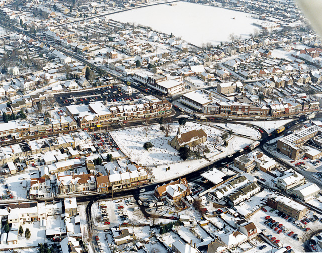
Aerial view of
Hadleigh centre in the snow The church in the middle of the picture is St James-the-less. The large building below left of this is The Castle pub. Most of the buildings lining the major roads here are shops. The large white rectangle at the top is a school playing field, with the
265:
501:"}},"text\/plain":{"en":{"":"URL"}}},"{\"value\":\"https:\\\/\\\/www.geograph.org.uk\\\/profile\\\/32907\",\"type\":\"string\"}":{"text\/html":{"en":{"P2699":"
215:
764:"}},"text\/plain":{"en":{"":"geograph.org.uk image ID"}}},"{\"value\":\"1563668\",\"type\":\"string\"}":{"text\/html":{"en":{"P7384":"
1268:== {{int:filedesc}} == {{Information |description={{en|1=Aerial view of Hadleigh centre in the snow The church in the middle of the picture is St James-the-less. The large building below left of this is The Castle pub. Most of the buildings lining the maj
83:
51:
407:– You must give appropriate credit, provide a link to the license, and indicate if changes were made. You may do so in any reasonable manner, but not in any way that suggests the licensor endorses you or your use.
279:
229:
765:
1016:
749:
637:
593:
757:
490:
1165:
1120:
1075:
1008:
970:
906:
902:
761:
745:
681:
677:
589:
498:
494:
486:
773:
502:
1012:
864:
769:
753:
633:
482:
1261:
1250:
1245:
640:"}},"text\/plain":{"en":{"P275":"Creative Commons Attribution-ShareAlike 2.0 Generic"}}}}": -->
42:
505:"}},"text\/plain":{"en":{"P2699":"https:\/\/www.geograph.org.uk\/profile\/32907"}}}}": -->
776:"}},"text\/plain":{"en":{"P973":"https:\/\/www.geograph.org.uk\/photo\/1563668"}}}}": -->
1060:
799:
663:
619:
289:
239:
819:
324:
1443:
This file contains additional information, probably added from the digital camera or scanner used to create or digitize it.
414:
546:
1179:
1134:
1089:
1026:
980:
947:
920:
827:
783:
722:
695:
603:
567:
554:
539:
1053:
874:
842:
812:
647:
512:
471:
370:
1446:
If the file has been modified from its original state, some details may not fully reflect the modified file.
1310:
1350:
1479:
413:– If you remix, transform, or build upon the material, you must distribute your contributions under the
331:
on the
Geograph website for the photographer's contact details. The copyright on this image is owned by
1082:"}},"text\/plain":{"en":{"P3575":"308,647 byte"}}}}": -->
596:"}},"text\/plain":{"en":{"P6216":"copyrighted"}}}}": -->
1172:"}},"text\/plain":{"en":{"P2049":"640 pixel"}}}}": -->
1127:"}},"text\/plain":{"en":{"P2048":"503 pixel"}}}}": -->
913:"}},"text\/plain":{"en":{"P7787":"67 degree"}}}}": -->
688:"}},"text\/plain":{"en":{"P7787":"67 degree"}}}}": -->
91:
184:
1320:
1019:"}},"text\/plain":{"en":{"P459":"SHA-1"}}}}": -->
849:
834:
574:
367:
168:
8:
311:
295:
245:
336:
78:
461:
1282:
157:
147:
1189:
1144:
1099:
1036:
990:
930:
884:
793:
705:
657:
613:
522:
116:
Aerial view of
Hadleigh centre in the snow - geograph.org.uk - 1563668.jpg
52:
Aerial_view_of_Hadleigh_centre_in_the_snow_-_geograph.org.uk_-_1563668.jpg
1494:
316:
328:
1218:
Click on a date/time to view the file as it appeared at that time.
281:
231:
1390:
1420:
1400:
1380:
1360:
1340:
1410:
1370:
1330:
266:
51° 33′ 11″ N, 0° 36′ 33″ E
216:
51° 32′ 55″ N, 0° 35′ 51″ E
66:
455:
Add a one-line explanation of what this file represents
136:
1430:
1300:
1276:
1291:
1216:
90:
Commons is a freely licensed media file repository.
664:
Creative
Commons Attribution-ShareAlike 2.0 Generic
638:
Creative
Commons Attribution-ShareAlike 2.0 Generic
1321:Hadleigh (lungsod sa Hiniusang Gingharian, Essex)
56:(640 × 503 pixels, file size: 301 KB, MIME type:
424:https://creativecommons.org/licenses/by-sa/2.0
71:
774:https:\/\/www.geograph.org.uk\/photo\/1563668
503:https:\/\/www.geograph.org.uk\/profile\/32907
430:Creative Commons Attribution-Share Alike 2.0
348:
132:
113:
153:
142:
14:
1169:
1124:
1079:
910:
685:
390:– to copy, distribute and transmit the work
199:Aerial view of Hadleigh centre in the snow
180:Aerial view of Hadleigh centre in the snow
1293:The following other wikis use this file:
850:https://www.geograph.org.uk/photo/1563668
575:https://www.geograph.org.uk/profile/32907
1042:168d5dafc65e052f7b6186f63b0df7966af5cd0f
288:View this and other nearby images on:
238:View this and other nearby images on:
191:
102:
335:and is licensed for reuse under the
256:
206:
1278:The following page uses this file:
1209:
371:Attribution-Share Alike 2.0 Generic
359:
354:
339:Attribution-ShareAlike 2.0 license.
13:
1441:
460:
454:
345:
322:
120:
103:
49:
1511:
1448:
459:
696:coordinates of the point of view
678:coordinates of the point of view
445:
401:Under the following conditions:
366:This file is licensed under the
358:
353:
347:
315:
294:
280:
272:
244:
230:
222:
70:
31:
21:
442:
121:
46:No higher resolution available.
1288:
1213:
800:file available on the internet
750:file available on the internet
441:
323:This image was taken from the
26:
1:
921:coordinates of depicted place
903:coordinates of depicted place
36:
1273:
820:Geograph Britain and Ireland
758:Geograph Britain and Ireland
540:object of statement has role
487:object of statement has role
467:Items portrayed in this file
307:
7:
1480:Adobe Photoshop CS3 Windows
1438:
1387:Usage on lld.wikipedia.org
1317:Usage on ceb.wikipedia.org
1307:Usage on azb.wikipedia.org
936:51°33'11.41"N, 0°36'32.76"E
711:51°32'55.50"N, 0°35'50.64"E
271:
221:
10:
1516:
1427:Usage on www.wikidata.org
1417:Usage on vo.wikipedia.org
1407:Usage on sv.wikipedia.org
1397:Usage on nl.wikipedia.org
1377:Usage on it.wikipedia.org
1367:Usage on ga.wikipedia.org
1357:Usage on fr.wikipedia.org
1347:Usage on fa.wikipedia.org
1337:Usage on eu.wikipedia.org
1327:Usage on cy.wikipedia.org
1297:Usage on af.wikipedia.org
415:same or compatible license
110:
105:
1486:File change date and time
1210:
197:Edward Clack /
178:Edward Clack /
16:
828:geograph.org.uk image ID
762:geograph.org.uk image ID
444:
381:
77:This is a file from the
41:
1267:
169:required by the license
135:
81:. Information from its
1489:11:56, 1 November 2009
329:this photograph's page
300:51.553170; 0.609100
250:51.548750; 0.597400
84:description page there
1460:Horizontal resolution
1054:determination method
1013:determination method
127:school to the right.
1468:Vertical resolution
1246:16:01, 3 March 2011
396:– to adapt the work
555:author name string
495:author name string
1503:
1502:
1289:Global file usage
1271:
1171:
1126:
1081:
912:
687:
648:copyright license
634:copyright license
453:
344:
343:
327:collection. See
305:
304:
255:
254:
204:
203:
172:
99:
98:
79:Wikimedia Commons
32:Global file usage
1507:
1449:
1421:Hadleigh (Essex)
1401:Hadleigh (Essex)
1391:Hadleigh (Essex)
1381:Hadleigh (Essex)
1361:Hadleigh (Essex)
1341:Hadleigh (Essex)
1258:
1220:
1198:
1153:
1108:
1063:
1058:
958:
957:
952:
852:
847:
843:described at URL
837:
832:
822:
817:
770:described at URL
733:
732:
727:
604:copyright status
590:copyright status
577:
572:
562:
559:
549:
544:
451:
437:
434:
431:
428:
425:
417:as the original.
379:
368:Creative Commons
362:
361:
357:
356:
351:
350:
337:Creative Commons
325:Geograph project
319:
312:
301:
298:
284:
283:
277:
276:
275:
269:
268:
257:
251:
248:
234:
233:
227:
226:
225:
219:
218:
207:
166:
138:
125:
117:
111:
95:
74:
73:
67:
61:
59:
1515:
1514:
1510:
1509:
1508:
1506:
1505:
1504:
1437:
1411:Hadleigh, Essex
1371:Hadleigh, Essex
1331:Hadleigh, Essex
1287:
1283:Hadleigh, Essex
1272:
1264:
1256:
1212:
1211:
1208:
1207:
1206:
1205:
1204:
1203:
1202:
1201:
1199:
1196:
1186:
1185:
1184:
1182:
1163:
1162:
1161:
1160:
1159:
1158:
1157:
1156:
1154:
1151:
1141:
1140:
1139:
1137:
1118:
1117:
1116:
1115:
1114:
1113:
1112:
1111:
1109:
1106:
1096:
1095:
1094:
1092:
1073:
1072:
1071:
1070:
1069:
1068:
1067:
1066:
1065:
1064:
1059:
1056:
1047:
1046:
1045:
1043:
1033:
1032:
1031:
1029:
1006:
1005:
1004:
1003:
1002:
1001:
1000:
999:
997:
987:
986:
985:
983:
968:
967:
966:
965:
964:
963:
962:
961:
960:
959:
955:
953:
950:
941:
940:
939:
937:
927:
926:
925:
923:
900:
899:
898:
897:
896:
895:
894:
893:
891:
881:
880:
879:
877:
862:
861:
860:
859:
858:
857:
856:
855:
854:
853:
848:
845:
839:
838:
833:
830:
824:
823:
818:
815:
806:
805:
804:
802:
790:
789:
788:
786:
743:
742:
741:
740:
739:
738:
737:
736:
735:
734:
730:
728:
725:
716:
715:
714:
712:
702:
701:
700:
698:
675:
674:
673:
672:
671:
670:
669:
668:
666:
654:
653:
652:
650:
631:
630:
629:
628:
627:
626:
625:
624:
622:
610:
609:
608:
606:
587:
586:
585:
584:
583:
582:
581:
580:
579:
578:
573:
570:
564:
563:
560:
557:
551:
550:
545:
542:
533:
532:
531:
529:
519:
518:
517:
515:
480:
479:
478:
477:
476:
474:
458:
457:
456:
439:
438:
435:
432:
429:
426:
423:
422:
380:
377:
374:
363:
340:
310:
299:
273:
264:
263:
260:Object location
249:
223:
214:
213:
210:Camera location
205:
194:
187:
175:
148:geograph.org.uk
128:
115:
108:
101:
100:
89:
88:
87:is shown below.
63:
57:
55:
48:
47:
12:
11:
5:
1513:
1501:
1500:
1497:
1491:
1490:
1487:
1483:
1482:
1477:
1473:
1472:
1469:
1465:
1464:
1461:
1457:
1456:
1453:
1440:
1436:
1435:
1434:
1433:
1425:
1424:
1423:
1415:
1414:
1413:
1405:
1404:
1403:
1395:
1394:
1393:
1385:
1384:
1383:
1375:
1374:
1373:
1365:
1364:
1363:
1355:
1354:
1353:
1345:
1344:
1343:
1335:
1334:
1333:
1325:
1324:
1323:
1315:
1314:
1313:
1305:
1304:
1303:
1290:
1286:
1285:
1275:
1270:
1269:
1266:
1262:
1259:
1253:
1248:
1243:
1239:
1238:
1235:
1232:
1229:
1226:
1223:
1215:
1200:
1194:
1192:
1191:
1190:
1188:
1187:
1183:
1178:
1176:
1175:
1174:
1173:
1167:
1155:
1149:
1147:
1146:
1145:
1143:
1142:
1138:
1133:
1131:
1130:
1129:
1128:
1122:
1110:
1104:
1102:
1101:
1100:
1098:
1097:
1093:
1088:
1086:
1085:
1084:
1083:
1077:
1052:
1051:
1050:
1049:
1048:
1044:
1041:
1039:
1038:
1037:
1035:
1034:
1030:
1025:
1023:
1022:
1021:
1020:
1018:
1014:
1010:
998:
995:
993:
992:
991:
989:
988:
984:
979:
977:
976:
975:
974:
972:
946:
945:
944:
943:
942:
938:
935:
933:
932:
931:
929:
928:
924:
919:
917:
916:
915:
914:
908:
904:
892:
889:
887:
886:
885:
883:
882:
878:
873:
871:
870:
869:
868:
866:
841:
840:
826:
825:
811:
810:
809:
808:
807:
803:
798:
796:
795:
794:
792:
791:
787:
784:source of file
782:
780:
779:
778:
777:
775:
771:
767:
763:
759:
755:
751:
747:
746:source of file
721:
720:
719:
718:
717:
713:
710:
708:
707:
706:
704:
703:
699:
694:
692:
691:
690:
689:
683:
679:
667:
662:
660:
659:
658:
656:
655:
651:
646:
644:
643:
642:
641:
639:
635:
623:
618:
616:
615:
614:
612:
611:
607:
602:
600:
599:
598:
597:
595:
591:
566:
565:
553:
552:
538:
537:
536:
535:
534:
530:
527:
525:
524:
523:
521:
520:
516:
511:
509:
508:
507:
506:
504:
500:
496:
492:
488:
484:
475:
470:
468:
465:
464:
463:
462:
450:
449:
446:
443:
421:
420:
419:
418:
408:
399:
398:
397:
391:
384:You are free:
375:
365:
364:
346:
342:
341:
320:
309:
306:
303:
302:
292:
286:
261:
253:
252:
242:
236:
211:
202:
201:
195:
192:
189:
188:
183:
176:
173:
161:
160:
155:
151:
150:
144:
140:
139:
134:
130:
129:
118:
109:
107:
104:
97:
96:
75:
65:
64:
45:
40:
39:
34:
29:
24:
19:
9:
6:
4:
3:
2:
1512:
1498:
1496:
1493:
1492:
1488:
1485:
1484:
1481:
1478:
1476:Software used
1475:
1474:
1470:
1467:
1466:
1462:
1459:
1458:
1454:
1451:
1450:
1447:
1444:
1432:
1429:
1428:
1426:
1422:
1419:
1418:
1416:
1412:
1409:
1408:
1406:
1402:
1399:
1398:
1396:
1392:
1389:
1388:
1386:
1382:
1379:
1378:
1376:
1372:
1369:
1368:
1366:
1362:
1359:
1358:
1356:
1352:
1349:
1348:
1346:
1342:
1339:
1338:
1336:
1332:
1329:
1328:
1326:
1322:
1319:
1318:
1316:
1312:
1309:
1308:
1306:
1302:
1299:
1298:
1296:
1295:
1294:
1284:
1281:
1280:
1279:
1265:
1260:
1254:
1252:
1249:
1247:
1244:
1241:
1240:
1236:
1233:
1230:
1227:
1224:
1222:
1221:
1219:
1193:
1181:
1177:
1148:
1136:
1132:
1103:
1091:
1087:
1062:
1055:
1040:
1028:
1024:
994:
982:
978:
949:
934:
922:
918:
890:February 1991
888:
876:
872:
851:
844:
836:
829:
821:
814:
801:
797:
785:
781:
724:
709:
697:
693:
665:
661:
649:
645:
621:
617:
605:
601:
576:
569:
556:
548:
541:
526:
514:
510:
473:
469:
466:
447:
440:
427:CC BY-SA 2.0
416:
412:
409:
406:
403:
402:
400:
395:
392:
389:
386:
385:
383:
382:
376:Attribution:
372:
369:
352:
338:
334:
330:
326:
321:
318:
314:
313:
297:
293:
291:
290:OpenStreetMap
287:
285:
267:
262:
259:
258:
247:
243:
241:
240:OpenStreetMap
237:
235:
217:
212:
209:
208:
200:
196:
190:
186:
182: /
181:
177:
170:
165:
163:
162:
159:
156:
152:
149:
145:
141:
137:February 1991
131:
124:
119:
112:
93:
86:
85:
80:
76:
69:
68:
62:
53:
44:
38:
35:
33:
30:
28:
25:
23:
20:
18:
15:
1445:
1442:
1292:
1277:
1217:
1214:File history
561:Edward Clack
547:photographer
491:photographer
410:
404:
393:
387:
378:Edward Clack
333:Edward Clack
332:
270:
220:
198:
185:CC BY-SA 2.0
179:
158:Edward Clack
122:
92:You can help
82:
50:
22:File history
1495:Color space
1452:Orientation
1351:هادلی، اسکس
1311:هادلی، اسکس
1263:GeographBot
620:copyrighted
594:copyrighted
411:share alike
405:attribution
164:Attribution
114:Description
1274:File usage
1255:640 × 503
1231:Dimensions
996:image/jpeg
981:media type
971:media type
528:some value
58:image/jpeg
27:File usage
1228:Thumbnail
1225:Date/Time
1090:data size
1076:data size
875:inception
865:inception
308:Licensing
193:InfoField
174:InfoField
123:English:
1439:Metadata
1431:Q2346831
1301:Hadleigh
1257:(301 KB)
1105:308,647
1027:checksum
1009:checksum
813:operator
754:operator
448:Captions
394:to remix
388:to share
373:license.
37:Metadata
1471:600 dpi
1463:600 dpi
1242:current
1237:Comment
948:heading
907:heading
835:1563668
766:1563668
723:heading
682:heading
513:creator
483:creator
472:depicts
452:English
106:Summary
54:
1455:Normal
1135:height
1121:height
956:degree
911:degree
731:degree
686:degree
278:
228:
154:Author
143:Source
1197:pixel
1180:width
1170:pixel
1166:width
1152:pixel
1125:pixel
1061:SHA-1
1017:SHA-1
146:From
1499:sRGB
1234:User
1195:640
1150:503
1107:byte
1080:byte
436:true
433:true
133:Date
17:File
954:67
729:67
568:URL
499:URL
1057::
951::
846::
831::
816::
726::
571::
558::
543::
171:)
167:(
94:.
60:)
Text is available under the Creative Commons Attribution-ShareAlike License. Additional terms may apply.
_heading:67.00&language=en)
_heading:67.00&language=en)
