1400:
958:"}},"text\/plain":{"en":{"":"checksum"}}},"{\"value\":\"1231eb3b82b113d1a8ce505e73eeb77952265ffe\",\"type\":\"string\"}":{"text\/html":{"en":{"P4092":"1231eb3b82b113d1a8ce505e73eeb77952265ffe"}},"text\/plain":{"en":{"P4092":"1231eb3b82b113d1a8ce505e73eeb77952265ffe"}}},"{\"value\":{\"entity-type\":\"property\",\"numeric-id\":459,\"id\":\"P459\"},\"type\":\"wikibase-entityid\"}":{"text\/html":{"en":{"":"
882:"}},"text\/plain":{"en":{"":"coordinates of the point of view"}}},"{\"value\":{\"latitude\":-10.416667,\"longitude\":56.634722,\"altitude\":null,\"precision\":1.0e-6,\"globe\":\"http:\\\/\\\/www.wikidata.org\\\/entity\\\/Q2\"},\"type\":\"globecoordinate\"}":{"text\/html":{"en":{"P1259":"10\u00b025'0.001"S, 56\u00b038'4.999"E"}},"text\/plain":{"en":{"P1259":"10\u00b025'0.001\"S, 56\u00b038'4.999\"E"}}}}": -->
844:"}},"text\/plain":{"en":{"":"inception"}}},"{\"value\":{\"time\":\"+2008-06-01T00:00:00Z\",\"timezone\":0,\"before\":0,\"after\":0,\"precision\":10,\"calendarmodel\":\"http:\\\/\\\/www.wikidata.org\\\/entity\\\/Q1985727\"},\"type\":\"time\"}":{"text\/html":{"en":{"P571":"June 2008"}},"text\/plain":{"en":{"P571":"June 2008"}}}}": -->
414:
498:
43:
154:
364:
352:
954:
168:
504:
384:
509:
99:
715:"}},"text\/plain":{"en":{"P275":"Creative Commons Attribution-ShareAlike 3.0 Unported"}}},"{\"value\":{\"entity-type\":\"item\",\"numeric-id\":18199165,\"id\":\"Q18199165\"},\"type\":\"wikibase-entityid\"}":{"text\/html":{"en":{"P275":"
707:"}},"text\/plain":{"en":{"P275":"GNU Free Documentation License, version 1.2 or later"}}},"{\"value\":{\"entity-type\":\"item\",\"numeric-id\":47001652,\"id\":\"Q47001652\"},\"type\":\"wikibase-entityid\"}":{"text\/html":{"en":{"P275":"
711:"}},"text\/plain":{"en":{"P275":"Creative Commons Attribution-ShareAlike 1.0 Generic"}}},"{\"value\":{\"entity-type\":\"item\",\"numeric-id\":14946043,\"id\":\"Q14946043\"},\"type\":\"wikibase-entityid\"}":{"text\/html":{"en":{"P275":"
703:"}},"text\/plain":{"en":{"P275":"Creative Commons Attribution-ShareAlike 2.5 Generic"}}},"{\"value\":{\"entity-type\":\"item\",\"numeric-id\":50829104,\"id\":\"Q50829104\"},\"type\":\"wikibase-entityid\"}":{"text\/html":{"en":{"P275":"
699:"}},"text\/plain":{"en":{"P275":"Creative Commons Attribution-ShareAlike 2.0 Generic"}}},"{\"value\":{\"entity-type\":\"item\",\"numeric-id\":19113751,\"id\":\"Q19113751\"},\"type\":\"wikibase-entityid\"}":{"text\/html":{"en":{"P275":"
920:"}},"text\/plain":{"en":{"":"media type"}}},"{\"value\":\"image\\\/svg+xml\",\"type\":\"string\"}":{"text\/html":{"en":{"P1163":"image\/svg+xml"}},"text\/plain":{"en":{"P1163":"image\/svg+xml"}}}}": -->
962:"}},"text\/plain":{"en":{"":"determination method"}}},"{\"value\":{\"entity-type\":\"item\",\"numeric-id\":13414952,\"id\":\"Q13414952\"},\"type\":\"wikibase-entityid\"}":{"text\/html":{"en":{"P459":"
695:"}},"text\/plain":{"en":{"":"copyright license"}}},"{\"value\":{\"entity-type\":\"item\",\"numeric-id\":19068220,\"id\":\"Q19068220\"},\"type\":\"wikibase-entityid\"}":{"text\/html":{"en":{"P275":"
651:"}},"text\/plain":{"en":{"":"copyright status"}}},"{\"value\":{\"entity-type\":\"item\",\"numeric-id\":50423863,\"id\":\"Q50423863\"},\"type\":\"wikibase-entityid\"}":{"text\/html":{"en":{"P6216":"
1025:"}},"text\/plain":{"en":{"":"data size"}}},"{\"value\":{\"amount\":\"+444590\",\"unit\":\"http:\\\/\\\/www.wikidata.org\\\/entity\\\/Q8799\"},\"type\":\"quantity\"}":{"text\/html":{"en":{"P3575":"444,590
1070:"}},"text\/plain":{"en":{"":"height"}}},"{\"value\":{\"amount\":\"+1825\",\"unit\":\"http:\\\/\\\/www.wikidata.org\\\/entity\\\/Q355198\"},\"type\":\"quantity\"}":{"text\/html":{"en":{"P2048":"1,825
1115:"}},"text\/plain":{"en":{"":"width"}}},"{\"value\":{\"amount\":\"+1500\",\"unit\":\"http:\\\/\\\/www.wikidata.org\\\/entity\\\/Q355198\"},\"type\":\"quantity\"}":{"text\/html":{"en":{"P2049":"1,500
1111:
567:– You must give appropriate credit, provide a link to the license, and indicate if changes were made. You may do so in any reasonable manner, but not in any way that suggests the licensor endorses you or your use.
151:
145:
963:
716:
712:
708:
704:
700:
696:
652:
1112:
1067:
1022:
955:
917:
879:
648:
959:
841:
692:
470:
424:
1435:
719:"}},"text\/plain":{"en":{"P275":"Creative Commons Attribution-ShareAlike 4.0 International"}}}}": -->
1215:== Summary == {{Location|10|25|00|S|56|38|05|E|scale:200000}} <br/>{{Information |Description={{en|Map in English of the archipelago of
399:
73:
69:
468:; with no Invariant Sections, no Front-Cover Texts, and no Back-Cover Texts. A copy of the license is included in the section entitled
309:
65:
61:
57:
53:
47:
428:
110:
1007:
827:
810:
793:
776:
759:
742:
678:
161:
82:
1488:
This file contains additional information, probably added from the digital camera or scanner used to create or digitize it.
574:
331:) as the author and distribute the copies and derivative works under the same license(s) that the one(s) stated below. A
1126:
1081:
1036:
973:
927:
889:
662:
460:
1000:
851:
726:
637:
277:
395:
413:
332:
536:
532:
528:
524:
520:
1491:
If the file has been modified from its original state, some details may not fully reflect the modified file.
1320:
465:
573:– If you remix, transform, or build upon the material, you must distribute your contributions under the
1465:
1029:"}},"text\/plain":{"en":{"P3575":"444,590 byte"}}}}": -->
1455:
1119:"}},"text\/plain":{"en":{"P2049":"1,500 pixel"}}}}": -->
1074:"}},"text\/plain":{"en":{"P2048":"1,825 pixel"}}}}": -->
655:"}},"text\/plain":{"en":{"P6216":"copyrighted"}}}}": -->
1330:
1475:
1310:
391:
272:
118:
966:"}},"text\/plain":{"en":{"P459":"SHA-1"}}}}": -->
363:
458:
Permission is granted to copy, distribute and/or modify this document under the terms of the
1197:
1192:
351:
42:
516:
297:
8:
1401:வரி ஒப்பந்தத்தைத் தக்க வைக்க மொரீசியசு இரண்டு தீவுகளை இந்தியாவுக்கு அளிக்க முன்வந்துள்ளது
1430:
167:
444:
I, the copyright holder of this work, hereby publish it under the following licenses:
383:
226:
105:
627:
196:
1216:
222:
1420:
1136:
1091:
1046:
983:
937:
899:
861:
821:
804:
787:
770:
753:
736:
672:
293:
200:
1242:
1223:.<br/> *UTM projection, WGS84 datum<br/> *Estimated scale :
1208:
1237:
327:
Any use of this map can be made as long as you credit me (Eric Gaba –
1220:
423:
into your language, using any capable SVG editor, text editor or the
447:
408:
1270:
1165:
Click on a date/time to view the file as it appeared at that time.
153:
1375:
1350:
87:(SVG file, nominally 1,500 × 1,825 pixels, file size: 434 KB)
328:
1280:
1360:
146:
10° 25′ 00″ S, 56° 38′ 05″ E
828:
Creative
Commons Attribution-ShareAlike 4.0 International
717:
Creative
Commons Attribution-ShareAlike 4.0 International
93:
335:
with a reply address would also be greatly appreciated.
1415:
1380:
1365:
1300:
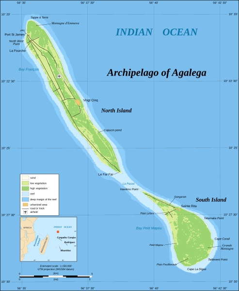
1290:
1260:
621:
Add a one-line explanation of what this file represents
1410:
273:
Floristics and
Ecology of Western Indian Ocean Islands
248:
1445:
1231:
1390:
1340:
1251:
1163:
811:
Creative
Commons Attribution-ShareAlike 3.0 Unported
777:
713:
Creative
Commons Attribution-ShareAlike 3.0 Unported
705:
464:, Version 1.2 or any later version published by the
117:
Commons is a freely licensed media file repository.
794:
Creative
Commons Attribution-ShareAlike 1.0 Generic
760:
Creative
Commons Attribution-ShareAlike 2.5 Generic
743:
Creative
Commons Attribution-ShareAlike 2.0 Generic
709:
Creative Commons Attribution-ShareAlike 1.0 Generic
701:
Creative Commons Attribution-ShareAlike 2.5 Generic
697:
Creative Commons Attribution-ShareAlike 2.0 Generic
402:to clean up, improve, create or translate as well.
584:https://creativecommons.org/licenses/by-sa/4.0
98:
590:Creative Commons Attribution-Share Alike 4.0
497:
304:
244:
182:
343:
288:
254:
14:
1116:
1071:
1026:
550:– to copy, distribute and transmit the work
46:Size of this PNG preview of this SVG file:
602:You may select the license of your choice.
1253:The following other wikis use this file:
390:This map was improved or created by the
989:1231eb3b82b113d1a8ce505e73eeb77952265ffe
160:View this and other nearby images on:
1233:The following 2 pages use this file:
237:Échelle estimée : 1:150 000
195:Map in English of the archipelago of
129:
476:http://www.gnu.org/copyleft/fdl.html
421:embedded text that can be translated
321:Attribution and Share-Alike required
136:
1156:
508:
503:
13:
1486:
626:
620:
601:
494:
443:
389:
215:
189:
130:
80:
1520:
1493:
625:
221:Carte en anglais de l'archipel d'
890:coordinates of the point of view
880:coordinates of the point of view
611:
561:Under the following conditions:
515:This file is licensed under the
507:
502:
496:
452:
451:
412:
382:
362:
350:
211:Estimated scale : 1:150,000
166:
152:
97:
31:
21:
608:
190:
1462:Usage on zh-yue.wikipedia.org
1248:
1160:
607:
482:GNU Free Documentation License
471:GNU Free Documentation License
461:GNU Free Documentation License
216:
26:
1:
329:Wikimedia Commons user: Sting
270:Place names: D. R. Stoddart,
36:
1228:
905:10°25'0.001"S, 56°38'4.999"E
633:Items portrayed in this file
437:
427:. For more information see:
411:
318:
7:
1483:
1421:Mauritius'un bölgeleri
1257:Usage on bar.wikipedia.org
429:About translating SVG files
267:Landsat ETM+ imagery ;
233:Projection UTM, WGS84 datum
207:UTM projection, WGS84 datum
10:
1525:
1472:Usage on zh.wikipedia.org
1452:Usage on yo.wikipedia.org
1442:Usage on www.wikidata.org
1427:Usage on uk.wikipedia.org
1407:Usage on tr.wikipedia.org
1387:Usage on sv.wikipedia.org
1372:Usage on ro.wikipedia.org
1357:Usage on pl.wikipedia.org
1347:Usage on nl.wikipedia.org
1337:Usage on lt.wikipedia.org
1327:Usage on ko.wikipedia.org
1317:Usage on ka.wikipedia.org
1307:Usage on ja.wikipedia.org
1297:Usage on it.wikipedia.org
1287:Usage on gl.wikipedia.org
1277:Usage on de.wikipedia.org
1267:Usage on cs.wikipedia.org
575:same or compatible license
418:
185:Agalega Islands map-en.svg
179:
132:
1397:Usage on ta.wikinews.org
1157:
16:
610:
541:
519:Attribution-Share Alike
466:Free Software Foundation
104:This is a file from the
41:
1214:
419:This SVG file contains
381:
276:(fig. 5, p. 66) ;
264:References used :
247:
172:-10.416667; 56.634722
108:. Information from its
111:description page there
1456:Àwọn Erékùṣù Agalega
1001:determination method
960:determination method
74:1,500 × 1,825 pixels
70:1,683 × 2,048 pixels
1193:13:42, 30 June 2008
556:– to adapt the work
398:(fr). You can
52:Other resolutions:
1436:Географія Маврикію
425:SVG Translate tool
66:842 × 1,024 pixels
1512:
1511:
1271:Agalegské ostrovy
1249:Global file usage
1226:
1118:
1073:
1028:
727:copyright license
693:copyright license
619:
521:4.0 International
493:
492:
435:
434:
407:
406:
376:
375:
339:
338:
313:
310:Reusing this file
177:
176:
126:
125:
106:Wikimedia Commons
32:Global file usage
1516:
1494:
1376:Insulele Agalega
1351:Agalega-eilanden
1205:
1167:
1145:
1100:
1055:
1010:
1005:
663:copyright status
649:copyright status
617:
597:
594:
591:
588:
585:
577:as the original.
517:Creative Commons
511:
510:
506:
505:
500:
499:
489:
486:
483:
480:
477:
455:
454:
448:
416:
409:
386:
379:
378:
366:
354:
317:
316:
307:
250:
220:
218:Français :
194:
186:
180:
173:
170:
156:
155:
149:
148:
137:
122:
101:
100:
94:
88:
77:
62:631 × 768 pixels
58:394 × 480 pixels
54:197 × 240 pixels
48:493 × 600 pixels
1524:
1523:
1519:
1518:
1517:
1515:
1514:
1513:
1482:
1247:
1227:
1211:
1203:
1159:
1158:
1155:
1154:
1153:
1152:
1151:
1150:
1149:
1148:
1146:
1143:
1133:
1132:
1131:
1129:
1110:
1109:
1108:
1107:
1106:
1105:
1104:
1103:
1101:
1098:
1088:
1087:
1086:
1084:
1065:
1064:
1063:
1062:
1061:
1060:
1059:
1058:
1056:
1053:
1043:
1042:
1041:
1039:
1020:
1019:
1018:
1017:
1016:
1015:
1014:
1013:
1012:
1011:
1006:
1003:
994:
993:
992:
990:
980:
979:
978:
976:
953:
952:
951:
950:
949:
948:
947:
946:
944:
934:
933:
932:
930:
915:
914:
913:
912:
911:
910:
909:
908:
906:
896:
895:
894:
892:
877:
876:
875:
874:
873:
872:
871:
870:
868:
858:
857:
856:
854:
839:
838:
837:
836:
835:
834:
833:
832:
830:
819:
818:
817:
816:
815:
813:
802:
801:
800:
799:
798:
796:
785:
784:
783:
782:
781:
779:
768:
767:
766:
765:
764:
762:
751:
750:
749:
748:
747:
745:
733:
732:
731:
729:
690:
689:
688:
687:
686:
685:
684:
683:
681:
669:
668:
667:
665:
646:
645:
644:
643:
642:
640:
624:
623:
622:
605:
604:
603:
599:
598:
595:
592:
589:
586:
583:
582:
540:
512:
487:
484:
481:
478:
475:
446:
445:
440:
403:
377:
370:
367:
358:
355:
240:
214:
184:
171:
144:
143:
140:Camera location
135:
128:
127:
116:
115:
114:is shown below.
90:
86:
79:
78:
51:
12:
11:
5:
1522:
1510:
1509:
1506:
1502:
1501:
1498:
1485:
1481:
1480:
1479:
1478:
1470:
1469:
1468:
1460:
1459:
1458:
1450:
1449:
1448:
1440:
1439:
1438:
1433:
1425:
1424:
1423:
1418:
1413:
1405:
1404:
1403:
1395:
1394:
1393:
1385:
1384:
1383:
1378:
1370:
1369:
1368:
1363:
1355:
1354:
1353:
1345:
1344:
1343:
1335:
1334:
1333:
1325:
1324:
1323:
1315:
1314:
1313:
1305:
1304:
1303:
1295:
1294:
1293:
1285:
1284:
1283:
1281:Agalega-Inseln
1275:
1274:
1273:
1265:
1264:
1263:
1250:
1246:
1245:
1240:
1230:
1225:
1224:
1213:
1209:
1206:
1202:1,500 × 1,825
1200:
1195:
1190:
1186:
1185:
1182:
1179:
1176:
1173:
1170:
1162:
1147:
1141:
1139:
1138:
1137:
1135:
1134:
1130:
1125:
1123:
1122:
1121:
1120:
1114:
1102:
1096:
1094:
1093:
1092:
1090:
1089:
1085:
1080:
1078:
1077:
1076:
1075:
1069:
1057:
1051:
1049:
1048:
1047:
1045:
1044:
1040:
1035:
1033:
1032:
1031:
1030:
1024:
999:
998:
997:
996:
995:
991:
988:
986:
985:
984:
982:
981:
977:
972:
970:
969:
968:
967:
965:
961:
957:
945:
942:
940:
939:
938:
936:
935:
931:
926:
924:
923:
922:
921:
919:
907:
904:
902:
901:
900:
898:
897:
893:
888:
886:
885:
884:
883:
881:
869:
866:
864:
863:
862:
860:
859:
855:
850:
848:
847:
846:
845:
843:
831:
826:
824:
823:
822:
820:
814:
809:
807:
806:
805:
803:
797:
792:
790:
789:
788:
786:
780:
775:
773:
772:
771:
769:
763:
758:
756:
755:
754:
752:
746:
741:
739:
738:
737:
735:
734:
730:
725:
723:
722:
721:
720:
718:
714:
710:
706:
702:
698:
694:
682:
677:
675:
674:
673:
671:
670:
666:
661:
659:
658:
657:
656:
654:
650:
641:
636:
634:
631:
630:
629:
628:
616:
615:
612:
609:
600:
581:
580:
579:
578:
568:
559:
558:
557:
551:
544:You are free:
514:
513:
495:
491:
490:
456:
442:
441:
439:
436:
433:
432:
417:
405:
404:
400:propose images
387:
374:
373:
372:
371:
368:
361:
359:
356:
349:
345:
344:Other versions
341:
340:
337:
336:
324:
323:
314:
302:
301:
290:
286:
285:
284:
283:
282:
281:
268:
256:
252:
251:
246:
242:
241:
239:
238:
235:
213:
212:
209:
187:
178:
175:
174:
164:
158:
141:
134:
131:
124:
123:
102:
92:
91:
45:
40:
39:
34:
29:
24:
19:
9:
6:
4:
3:
2:
1521:
1507:
1504:
1503:
1499:
1496:
1495:
1492:
1489:
1477:
1474:
1473:
1471:
1467:
1464:
1463:
1461:
1457:
1454:
1453:
1451:
1447:
1444:
1443:
1441:
1437:
1434:
1432:
1429:
1428:
1426:
1422:
1419:
1417:
1414:
1412:
1409:
1408:
1406:
1402:
1399:
1398:
1396:
1392:
1389:
1388:
1386:
1382:
1379:
1377:
1374:
1373:
1371:
1367:
1364:
1362:
1361:Wyspy Agalega
1359:
1358:
1356:
1352:
1349:
1348:
1346:
1342:
1339:
1338:
1336:
1332:
1329:
1328:
1326:
1322:
1319:
1318:
1316:
1312:
1309:
1308:
1306:
1302:
1299:
1298:
1296:
1292:
1289:
1288:
1286:
1282:
1279:
1278:
1276:
1272:
1269:
1268:
1266:
1262:
1259:
1258:
1256:
1255:
1254:
1244:
1241:
1239:
1236:
1235:
1234:
1222:
1218:
1212:
1207:
1201:
1199:
1196:
1194:
1191:
1188:
1187:
1183:
1180:
1177:
1174:
1171:
1169:
1168:
1166:
1140:
1128:
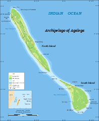
1124:
1095:
1083:
1079:
1050:
1038:
1034:
1009:
1002:
987:
975:
971:
943:image/svg+xml
941:
929:
925:
903:
891:
887:
865:
853:
849:
829:
825:
812:
808:
795:
791:
778:
774:
761:
757:
744:
740:
728:
724:
680:
676:
664:
660:
639:
635:
632:
613:
606:
587:CC BY-SA 4.0
576:
572:
569:
566:
563:
562:
560:
555:
552:
549:
546:
545:
543:
542:
538:
534:
530:
526:
522:
518:
501:
473:
472:
467:
463:
462:
457:
450:
449:
430:
426:
422:
415:
410:
401:
397:
393:
392:Wikigraphists
388:
385:
380:
365:
360:
353:
348:
347:
346:
342:
334:
330:
326:
325:
322:
319:
315:
311:
306:
303:
299:
295:
291:
287:
279:
275:
274:
269:
266:
265:
263:
262:
261:
260:
257:
253:
243:
236:
234:
232:
231:
230:
228:
224:
219:
210:
208:
206:
205:
204:
202:
198:
193:
188:
181:
169:
165:
163:
162:OpenStreetMap
159:
157:
147:
142:
139:
138:
120:
113:
112:
107:
103:
96:
95:
89:
84:
83:Original file
75:
71:
67:
63:
59:
55:
49:
44:
38:
35:
33:
30:
28:
25:
23:
20:
18:
15:
1490:
1487:
1252:
1232:
1164:
1161:File history
570:
564:
553:
547:
525:3.0 Unported
469:
459:
420:
320:
271:
258:
217:
191:
119:You can help
109:
81:
22:File history
679:copyrighted
653:copyrighted
571:share alike
565:attribution
537:1.0 Generic
533:2.0 Generic
529:2.5 Generic
396:Graphic Lab
292:Eric Gaba (
183:Description
1416:Vingt Cinq
1381:Vingt Cinq
1366:Vingt Cinq
1301:Vingt Cinq
1291:Vingt Cinq
1243:Vingt-Cinq
1229:File usage
1178:Dimensions
928:media type
918:media type
369:македонски
305:Permission
27:File usage
1411:Mauritius
1261:Mauritius
1221:Mauritius
1175:Thumbnail
1172:Date/Time
1037:data size
1023:data size
867:June 2008
852:inception
842:inception
438:Licensing
278:Wikimapia
249:June 2008
201:Mauritius
192:English:
1484:Metadata
1446:Q2191422
1204:(434 KB)
1052:444,590
974:checksum
956:checksum
614:Captions
554:to remix
548:to share
539:license.
357:français
298:fr:Sting
259:Own work
37:Metadata
1431:Агалега
1391:Agalega
1341:Agalega
1331:아갈레가 제도
1321:აგალეგა
1238:Agaléga
1217:Agalega
1189:current
1184:Comment
638:depicts
618:English
394:of the
333:message
227:Maurice
223:Agaléga
197:Agalega
133:Summary
85:
1505:Height
1476:阿加萊加群島
1466:阿加萊加群島
1311:アガレガ諸島
1142:1,500
1097:1,825
1082:height
1068:height
289:Author
255:Source
150:
1497:Width
1210:Sting
1144:pixel
1127:width
1117:pixel
1113:width
1099:pixel
1072:pixel
1008:SHA-1
964:SHA-1
294:Sting
1508:1825
1500:1500
1181:User
1054:byte
1027:byte
596:true
593:true
535:and
488:true
485:true
479:GFDL
245:Date
17:File
1219:,
1004::
531:,
527:,
523:,
431:.
296:-
225:,
199:,
72:|
68:|
64:|
60:|
56:|
50:.
474:.
312:)
308:(
300:)
280:.
229:.
203:.
121:.
76:.
Text is available under the Creative Commons Attribution-ShareAlike License. Additional terms may apply.
