1056:"}},"text\/plain":{"en":{"":"checksum"}}},"{\"value\":\"896011cfc165771a310dd8db5cd76554bb6816d7\",\"type\":\"string\"}":{"text\/html":{"en":{"P4092":"896011cfc165771a310dd8db5cd76554bb6816d7"}},"text\/plain":{"en":{"P4092":"896011cfc165771a310dd8db5cd76554bb6816d7"}}},"{\"value\":{\"entity-type\":\"property\",\"numeric-id\":459,\"id\":\"P459\"},\"type\":\"wikibase-entityid\"}":{"text\/html":{"en":{"":"
936:"}},"text\/plain":{"en":{"":"inception"}}},"{\"value\":{\"time\":\"+2010-05-03T00:00:00Z\",\"timezone\":0,\"before\":0,\"after\":0,\"precision\":11,\"calendarmodel\":\"http:\\\/\\\/www.wikidata.org\\\/entity\\\/Q1985727\"},\"type\":\"time\"}":{"text\/html":{"en":{"P571":"3 May 2010"}},"text\/plain":{"en":{"P571":"3 May 2010"}}}}": -->
737:
38:
1052:
447:
327:
94:
749:"}},"text\/plain":{"en":{"P2093":"NordNordWest","P4174":"NordNordWest"}}},"{\"value\":{\"entity-type\":\"property\",\"numeric-id\":4174,\"id\":\"P4174\"},\"type\":\"wikibase-entityid\"}":{"text\/html":{"en":{"":"
1018:"}},"text\/plain":{"en":{"":"media type"}}},"{\"value\":\"image\\\/svg+xml\",\"type\":\"string\"}":{"text\/html":{"en":{"P1163":"image\/svg+xml"}},"text\/plain":{"en":{"P1163":"image\/svg+xml"}}}}": -->
1060:"}},"text\/plain":{"en":{"":"determination method"}}},"{\"value\":{\"entity-type\":\"item\",\"numeric-id\":13414952,\"id\":\"Q13414952\"},\"type\":\"wikibase-entityid\"}":{"text\/html":{"en":{"P459":"
892:"}},"text\/plain":{"en":{"":"copyright license"}}},"{\"value\":{\"entity-type\":\"item\",\"numeric-id\":19068220,\"id\":\"Q19068220\"},\"type\":\"wikibase-entityid\"}":{"text\/html":{"en":{"P275":"
848:"}},"text\/plain":{"en":{"":"copyright status"}}},"{\"value\":{\"entity-type\":\"item\",\"numeric-id\":50423863,\"id\":\"Q50423863\"},\"type\":\"wikibase-entityid\"}":{"text\/html":{"en":{"P6216":"
974:"}},"text\/plain":{"en":{"":"source of file"}}},"{\"value\":{\"entity-type\":\"item\",\"numeric-id\":66458942,\"id\":\"Q66458942\"},\"type\":\"wikibase-entityid\"}":{"text\/html":{"en":{"P7482":"
1123:"}},"text\/plain":{"en":{"":"data size"}}},"{\"value\":{\"amount\":\"+57522\",\"unit\":\"http:\\\/\\\/www.wikidata.org\\\/entity\\\/Q8799\"},\"type\":\"quantity\"}":{"text\/html":{"en":{"P3575":"57,522
753:"}},"text\/plain":{"en":{"":"Wikimedia username"}}},"{\"value\":{\"entity-type\":\"property\",\"numeric-id\":2699,\"id\":\"P2699\"},\"type\":\"wikibase-entityid\"}":{"text\/html":{"en":{"":"
1168:"}},"text\/plain":{"en":{"":"height"}}},"{\"value\":{\"amount\":\"+1604\",\"unit\":\"http:\\\/\\\/www.wikidata.org\\\/entity\\\/Q355198\"},\"type\":\"quantity\"}":{"text\/html":{"en":{"P2048":"1,604
1213:"}},"text\/plain":{"en":{"":"width"}}},"{\"value\":{\"amount\":\"+1777\",\"unit\":\"http:\\\/\\\/www.wikidata.org\\\/entity\\\/Q355198\"},\"type\":\"quantity\"}":{"text\/html":{"en":{"P2049":"1,777
741:"}},"text\/plain":{"en":{"":"creator"}}},"{\"value\":{\"entity-type\":\"property\",\"numeric-id\":2093,\"id\":\"P2093\"},\"type\":\"wikibase-entityid\"}":{"text\/html":{"en":{"":"
1209:
1538:
368:– You must give appropriate credit, provide a link to the license, and indicate if changes were made. You may do so in any reasonable manner, but not in any way that suggests the licensor endorses you or your use.
746:
758:
1061:
975:
893:
849:
1480:
1475:
1583:
1568:
1390:
1210:
1165:
1120:
1053:
1015:
971:
845:
754:
750:
742:
1057:
933:
889:
738:
1495:
1490:
761:"}},"text\/plain":{"en":{"P2699":"http:\/\/commons.wikimedia.org\/wiki\/User:NordNordWest"}}}}": -->
1807:
896:"}},"text\/plain":{"en":{"P275":"Creative Commons Attribution-ShareAlike 2.0 Generic"}}}}": -->
461:
1470:
300:
236:
68:
64:
60:
56:
52:
48:
42:
1603:
1105:
1001:
919:
875:
1355:
105:
77:
375:
1224:
1179:
1134:
1071:
1025:
985:
859:
823:
808:
795:
978:"}},"text\/plain":{"en":{"P7482":"original creation by uploader"}}}}": -->
1588:
1098:
943:
903:
768:
727:
1485:
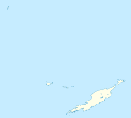
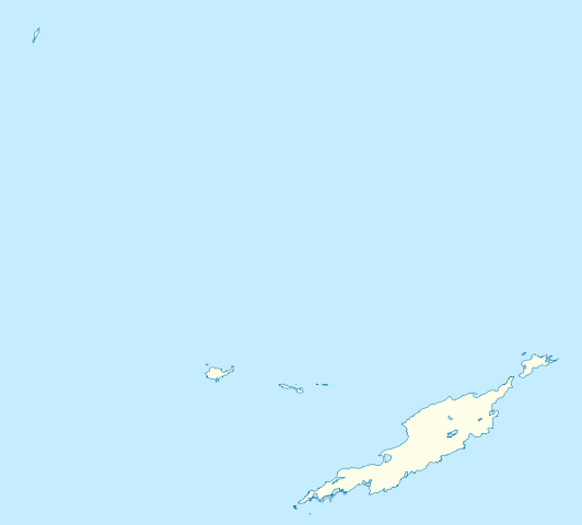
1317:}} Geographische Begrenzung der Karte: * N: 18.62° N * S: 18.14° N * W: 63.46° W * O: 62.90° W {{en|Location map of
815:
1578:
337:
686:
454:
1613:
374:– If you remix, transform, or build upon the material, you must distribute your contributions under the
433:
1558:
1217:"}},"text\/plain":{"en":{"P2049":"1,777 pixel"}}}}": -->
1172:"}},"text\/plain":{"en":{"P2048":"1,604 pixel"}}}}": -->
1127:"}},"text\/plain":{"en":{"P3575":"57,522 byte"}}}}": -->
852:"}},"text\/plain":{"en":{"P6216":"copyrighted"}}}}": -->
1385:
1553:
1425:
1345:
830:
113:
1598:
1430:
1415:
1064:"}},"text\/plain":{"en":{"P459":"SHA-1"}}}}": -->
1455:
1435:
1380:
1633:
1440:
1420:
1405:
1400:
1365:
1295:
1290:
334:
261:
This map may be incomplete, and may contain errors. Don't rely solely on it for navigation.
37:
8:
1395:
446:
1528:
1465:
1370:
1350:
1335:
225:
1410:
1306:
308:
100:
717:
496:
409:
1460:
1450:
256:
604:
568:
1445:
676:
667:
658:
649:
640:
631:
622:
613:
595:
586:
577:
559:
550:
541:
532:
523:
514:
505:
487:
478:
469:
1513:
1313:== {{int:filedesc}} == {{Information |Description= {{de|Positionskarte von
1234:
1189:
1144:
1081:
1035:
995:
953:
913:
869:
778:
1375:
1360:
1314:
149:
1340:
177:
1318:
1263:
Click on a date/time to view the file as it appeared at that time.
1718:
1523:
1628:
1548:
279:
1728:
1783:
1688:
82:(SVG file, nominally 1,777 × 1,604 pixels, file size: 56 KB)
1678:
1481:
Knowledge:WikiProject
Rosblofnari/DYK A-Z country challenge
1476:
User:Michael!/Project:Location map templates/United
Kingdom
1773:
1763:
1758:
1738:
1693:
1683:
1638:
1391:
List of fossiliferous stratigraphic units in the
Caribbean
1778:
1768:
1753:
1748:
1733:
1668:
205:
88:
1798:
1788:
1743:
1723:
1713:
1708:
1698:
1658:
1673:
1653:
1648:
759:
http:\/\/commons.wikimedia.org\/wiki\/User:NordNordWest
711:
Add a one-line explanation of what this file represents
418:
If inappropriate please set warp_status = skip to hide.
1793:
1663:
1643:
1623:
1614:Šablon:Lokacijska karta Ujedinjeno Kraljevstvo Angvila
1329:
1703:
1504:
1496:
Module:Location map/data/United
Kingdom Anguilla/doc
1261:
112:
Commons is a freely licensed media file repository.
920:
Creative
Commons Attribution-ShareAlike 2.0 Generic
894:
Creative
Commons Attribution-ShareAlike 2.0 Generic
404:
311:Attribution-ShareAlike 2.0 license (CC-BY-SA 2.0).
307:OpenStreetMap data and maps are licensed under the
453:This map has been made or improved in the German
1491:Module:Location map/data/United Kingdom Anguilla
1634:Plantilya:Location map United Kingdom Anguilla
1559:Módulu:Mapa de llocalización/datos/Anguila/usu
831:http://commons.wikimedia.org/User:NordNordWest
385:https://creativecommons.org/licenses/by-sa/2.0
93:
391:Creative Commons Attribution-Share Alike 2.0
315:
295:
267:
247:
231:
201:
135:
428:
285:
275:
221:
211:
14:
1214:
1169:
1124:
351:– to copy, distribute and transmit the work
41:Size of this PNG preview of this SVG file:
1554:Módulu:Mapa de llocalización/datos/Anguila
1471:User:Dr. Blofeld/DYK A-Z country challenge
259:project data, collected by the community.
244:
1506:The following other wikis use this file:
1539:قالب:خريطة مواقع المملكة المتحدة/أنغويلا
1087:896011cfc165771a310dd8db5cd76554bb6816d7
412:Georeference the map in Wikimaps Warper
1529:Plantilla:Mapa de localización Anguila
1356:Clayton J. Lloyd International Airport
1331:The following 33 pages use this file:
432:Derivative works of this file:
124:
154:Geographische Begrenzung der Karte:
1254:
338:Attribution-Share Alike 2.0 Generic
326:
321:
13:
716:
710:
452:
312:
170:
142:
125:
75:
1819:
1486:Module:Location map/data/Anguilla
715:
701:
445:
362:Under the following conditions:
333:This file is licensed under the
325:
320:
314:
92:
31:
21:
698:
497:
171:
1514:Sjabloon:Liggingkaart Anguilla
1501:
1258:
697:
182:Geographic limits of the map:
143:
26:
1:
1002:original creation by uploader
976:original creation by uploader
410:
1326:
723:Items portrayed in this file
7:
1620:Usage on ceb.wikipedia.org
1545:Usage on ast.wikipedia.org
255:This map was created from
10:
1824:
1610:Usage on bs.wikipedia.org
1595:Usage on bg.wikipedia.org
1575:Usage on be.wikipedia.org
1565:Usage on ba.wikipedia.org
1535:Usage on ar.wikipedia.org
1520:Usage on an.wikipedia.org
1510:Usage on af.wikipedia.org
441:
376:same or compatible license
290:OpenStreetMap contributors
132:
127:
1255:
605:
569:
250:Anguilla location map.svg
215:
138:Anguilla location map.svg
16:
1386:Island Harbour, Anguilla
700:
677:
668:
659:
650:
641:
632:
623:
614:
596:
587:
578:
560:
551:
542:
533:
524:
515:
506:
488:
479:
470:
342:
99:This is a file from the
36:
1584:Шаблон:На карце/Ангілья
1426:Sandy Island (Anguilla)
1346:Blowing Point, Anguilla
1312:
204:
103:. Information from its
1569:Ҡалып:ПозКарта Ангилья
1431:Scrub Island, Anguilla
1416:Sandy Ground, Anguilla
106:description page there
1456:The Quarter, Anguilla
1436:Seal Island, Anguilla
1381:George Hill, Anguilla
1524:The Valley (Anguila)
1441:South Hill, Anguilla
1421:Sandy Hill, Anguilla
1406:North Side, Anguilla
1401:North Hill, Anguilla
1366:Dog Island, Anguilla
1099:determination method
1058:determination method
464:to improve as well.
434:Anguilla islands.svg
69:1,777 × 1,604 pixels
65:2,269 × 2,048 pixels
61:1,134 × 1,024 pixels
1719:Sombrero (pagklaro)
1396:Little Scrub Island
357:– to adapt the work
148:Positionskarte von
47:Other resolutions:
1629:Gumagamit:Lsj/Test
1549:El Valle (Anguila)
1466:West End, Anguilla
1371:East End, Anguilla
1351:Carimar Beach Club
1336:Anguilla Formation
809:Wikimedia username
796:author name string
751:Wikimedia username
743:author name string
498:Deutsch (Sie-Form)
271:(see file history)
1808:more global usage
1502:Global file usage
1411:Prickly Pear Cays
1324:
1291:18:34, 3 May 2010
1216:
1171:
1126:
904:copyright license
890:copyright license
709:
695:
694:
689:
439:
438:
423:
422:
419:
304:
301:Reusing this file
280:openstreetmap.org
262:
240:
237:Reusing this file
121:
120:
101:Wikimedia Commons
32:Global file usage
1815:
1604:Шаблон:ПК Ангила
1303:
1265:
1243:
1198:
1153:
1108:
1103:
860:copyright status
846:copyright status
833:
828:
818:
813:
803:
800:
707:
690:
685:
449:
442:
417:
416:
414:
413:
398:
395:
392:
389:
386:
378:as the original.
335:Creative Commons
329:
328:
324:
323:
318:
317:
309:Creative Commons
298:
260:
251:
245:
234:
217:
207:
176:Location map of
175:
147:
139:
133:
117:
96:
95:
89:
83:
72:
57:851 × 768 pixels
53:532 × 480 pixels
49:266 × 240 pixels
43:664 × 599 pixels
1823:
1822:
1818:
1817:
1816:
1814:
1813:
1812:
1729:Sombrero Island
1500:
1461:Wallblake House
1325:
1309:
1301:
1257:
1256:
1253:
1252:
1251:
1250:
1249:
1248:
1247:
1246:
1244:
1241:
1231:
1230:
1229:
1227:
1208:
1207:
1206:
1205:
1204:
1203:
1202:
1201:
1199:
1196:
1186:
1185:
1184:
1182:
1163:
1162:
1161:
1160:
1159:
1158:
1157:
1156:
1154:
1151:
1141:
1140:
1139:
1137:
1118:
1117:
1116:
1115:
1114:
1113:
1112:
1111:
1110:
1109:
1104:
1101:
1092:
1091:
1090:
1088:
1078:
1077:
1076:
1074:
1051:
1050:
1049:
1048:
1047:
1046:
1045:
1044:
1042:
1032:
1031:
1030:
1028:
1013:
1012:
1011:
1010:
1009:
1008:
1007:
1006:
1004:
992:
991:
990:
988:
969:
968:
967:
966:
965:
964:
963:
962:
960:
950:
949:
948:
946:
931:
930:
929:
928:
927:
926:
925:
924:
922:
910:
909:
908:
906:
887:
886:
885:
884:
883:
882:
881:
880:
878:
866:
865:
864:
862:
843:
842:
841:
840:
839:
838:
837:
836:
835:
834:
829:
826:
820:
819:
814:
811:
805:
804:
801:
798:
789:
788:
787:
785:
775:
774:
773:
771:
736:
735:
734:
733:
732:
730:
714:
713:
712:
691:
679:
670:
661:
652:
643:
634:
625:
616:
607:
598:
589:
580:
571:
562:
553:
544:
535:
526:
517:
508:
499:
490:
481:
472:
468:
465:
455:Kartenwerkstatt
440:
424:
411:
408:
400:
399:
396:
393:
390:
387:
384:
383:
341:
330:
291:
263:
249:
180:
152:
137:
130:
123:
122:
111:
110:
109:is shown below.
85:
81:
74:
73:
46:
12:
11:
5:
1821:
1810:of this file.
1804:
1803:
1802:
1801:
1796:
1791:
1786:
1784:Sandy Hill Bay
1781:
1776:
1771:
1766:
1761:
1756:
1751:
1746:
1741:
1736:
1731:
1726:
1721:
1716:
1711:
1706:
1701:
1696:
1691:
1689:Windward Point
1686:
1681:
1676:
1671:
1666:
1661:
1656:
1651:
1646:
1641:
1636:
1631:
1626:
1618:
1617:
1616:
1608:
1607:
1606:
1601:
1593:
1592:
1591:
1586:
1581:
1579:Вэлі (Ангілья)
1573:
1572:
1571:
1563:
1562:
1561:
1556:
1551:
1543:
1542:
1541:
1533:
1532:
1531:
1526:
1518:
1517:
1516:
1503:
1499:
1498:
1493:
1488:
1483:
1478:
1473:
1468:
1463:
1458:
1453:
1451:The Farrington
1448:
1443:
1438:
1433:
1428:
1423:
1418:
1413:
1408:
1403:
1398:
1393:
1388:
1383:
1378:
1373:
1368:
1363:
1358:
1353:
1348:
1343:
1338:
1328:
1323:
1322:
1311:
1307:
1304:
1300:1,777 × 1,604
1298:
1293:
1288:
1284:
1283:
1280:
1277:
1274:
1271:
1268:
1260:
1245:
1239:
1237:
1236:
1235:
1233:
1232:
1228:
1223:
1221:
1220:
1219:
1218:
1212:
1200:
1194:
1192:
1191:
1190:
1188:
1187:
1183:
1178:
1176:
1175:
1174:
1173:
1167:
1155:
1149:
1147:
1146:
1145:
1143:
1142:
1138:
1133:
1131:
1130:
1129:
1128:
1122:
1097:
1096:
1095:
1094:
1093:
1089:
1086:
1084:
1083:
1082:
1080:
1079:
1075:
1070:
1068:
1067:
1066:
1065:
1063:
1059:
1055:
1043:
1040:
1038:
1037:
1036:
1034:
1033:
1029:
1024:
1022:
1021:
1020:
1019:
1017:
1005:
1000:
998:
997:
996:
994:
993:
989:
986:source of file
984:
982:
981:
980:
979:
977:
973:
972:source of file
961:
958:
956:
955:
954:
952:
951:
947:
942:
940:
939:
938:
937:
935:
923:
918:
916:
915:
914:
912:
911:
907:
902:
900:
899:
898:
897:
895:
891:
879:
874:
872:
871:
870:
868:
867:
863:
858:
856:
855:
854:
853:
851:
847:
822:
821:
807:
806:
794:
793:
792:
791:
790:
786:
783:
781:
780:
779:
777:
776:
772:
767:
765:
764:
763:
762:
760:
756:
752:
748:
744:
740:
731:
726:
724:
721:
720:
719:
718:
706:
705:
702:
699:
693:
692:
467:
450:
437:
436:
430:
429:Other versions
426:
425:
421:
420:
406:
405:Georeferencing
402:
401:
382:
381:
380:
379:
369:
360:
359:
358:
352:
345:You are free:
332:
331:
313:
305:
293:
292:
289:
287:
283:
282:
277:
273:
272:
269:
265:
264:
254:
252:
243:
241:
229:
228:
223:
219:
218:
213:
209:
208:
203:
199:
198:
197:
196:
193:
190:
187:
169:
168:
165:
162:
159:
140:
131:
129:
126:
119:
118:
97:
87:
86:
40:
35:
34:
29:
24:
19:
9:
6:
4:
3:
2:
1820:
1811:
1809:
1800:
1797:
1795:
1792:
1790:
1787:
1785:
1782:
1780:
1777:
1775:
1772:
1770:
1767:
1765:
1762:
1760:
1757:
1755:
1752:
1750:
1747:
1745:
1742:
1740:
1737:
1735:
1732:
1730:
1727:
1725:
1722:
1720:
1717:
1715:
1712:
1710:
1707:
1705:
1702:
1700:
1697:
1695:
1692:
1690:
1687:
1685:
1682:
1680:
1679:Little Island
1677:
1675:
1672:
1670:
1667:
1665:
1662:
1660:
1657:
1655:
1652:
1650:
1647:
1645:
1642:
1640:
1637:
1635:
1632:
1630:
1627:
1625:
1622:
1621:
1619:
1615:
1612:
1611:
1609:
1605:
1602:
1600:
1597:
1596:
1594:
1590:
1589:Сандзі-Граўнд
1587:
1585:
1582:
1580:
1577:
1576:
1574:
1570:
1567:
1566:
1564:
1560:
1557:
1555:
1552:
1550:
1547:
1546:
1544:
1540:
1537:
1536:
1534:
1530:
1527:
1525:
1522:
1521:
1519:
1515:
1512:
1511:
1509:
1508:
1507:
1497:
1494:
1492:
1489:
1487:
1484:
1482:
1479:
1477:
1474:
1472:
1469:
1467:
1464:
1462:
1459:
1457:
1454:
1452:
1449:
1447:
1446:Stoney Ground
1444:
1442:
1439:
1437:
1434:
1432:
1429:
1427:
1424:
1422:
1419:
1417:
1414:
1412:
1409:
1407:
1404:
1402:
1399:
1397:
1394:
1392:
1389:
1387:
1384:
1382:
1379:
1377:
1374:
1372:
1369:
1367:
1364:
1362:
1359:
1357:
1354:
1352:
1349:
1347:
1344:
1342:
1339:
1337:
1334:
1333:
1332:
1320:
1316:
1310:
1305:
1299:
1297:
1294:
1292:
1289:
1286:
1285:
1281:
1278:
1275:
1272:
1269:
1267:
1266:
1264:
1238:
1226:
1222:
1193:
1181:
1177:
1148:
1136:
1132:
1107:
1100:
1085:
1073:
1069:
1041:image/svg+xml
1039:
1027:
1023:
1003:
999:
987:
983:
957:
945:
941:
921:
917:
905:
901:
877:
873:
861:
857:
832:
825:
817:
810:
797:
782:
770:
766:
729:
725:
722:
703:
696:
688:
684:
680:
675:
671:
666:
662:
657:
653:
648:
644:
639:
635:
630:
626:
621:
617:
612:
608:
603:
599:
594:
590:
585:
581:
576:
572:
567:
563:
558:
554:
549:
545:
540:
536:
531:
527:
522:
518:
513:
509:
504:
500:
495:
491:
486:
482:
477:
473:
466:
463:
459:
456:
451:
448:
444:
443:
435:
431:
427:
415:
407:
403:
388:CC BY-SA 2.0
377:
373:
370:
367:
364:
363:
361:
356:
353:
350:
347:
346:
344:
343:
339:
336:
319:
310:
306:
302:
297:
294:
288:
284:
281:
278:
274:
270:
266:
258:
257:OpenStreetMap
253:
246:
242:
238:
233:
230:
227:
224:
220:
214:
210:
200:
194:
191:
188:
185:
184:
183:
179:
174:
166:
163:
160:
157:
156:
155:
151:
146:
141:
134:
115:
108:
107:
102:
98:
91:
90:
84:
79:
78:Original file
70:
66:
62:
58:
54:
50:
44:
39:
33:
30:
28:
25:
23:
20:
18:
15:
1805:
1774:Savannah Bay
1764:Scrub Island
1759:Seal Islands
1739:Lovers Point
1694:Warner Point
1684:Blowing Rock
1639:Sandy Island
1505:
1330:
1308:NordNordWest
1262:
1259:File history
816:NordNordWest
802:NordNordWest
747:NordNordWest
682:
673:
664:
655:
646:
637:
628:
619:
610:
601:
592:
583:
574:
570:Plattdüütsch
565:
556:
547:
538:
529:
520:
511:
502:
493:
484:
475:
471:azərbaycanca
462:propose maps
457:
371:
365:
354:
348:
226:NordNordWest
181:
172:
153:
144:
114:You can help
104:
76:
22:File history
1779:Sand Island
1769:Scrub Islet
1754:Seal Islets
1749:Seal Island
1734:Snake Point
1669:Sandy Point
1599:Вали (град)
1376:Flirt Rocks
1361:Crocus Hill
876:copyrighted
850:copyrighted
615:slovenščina
372:share alike
366:attribution
248:Description
195:E: 62.90° W
192:W: 63.46° W
189:S: 18.14° N
186:N: 18.62° N
167:O: 62.90° W
164:W: 63.46° W
161:S: 18.14° N
158:N: 18.62° N
136:Description
1799:North Side
1789:Road Point
1744:Seal Rocks
1724:Hat Island
1714:Spring Bay
1709:Stoney Bay
1699:The Valley
1659:West Point
1341:Anguillita
1327:File usage
1321:}} Geograp
1276:Dimensions
1026:media type
1016:media type
959:3 May 2010
784:some value
633:македонски
561:Nederlands
460:. You can
296:Permission
232:Permission
206:3 May 2010
27:File usage
1674:Long Rock
1654:Shoal Bay
1649:Great Bay
1273:Thumbnail
1270:Date/Time
1135:data size
1121:data size
944:inception
934:inception
606:sicilianu
588:português
458:(Map Lab)
173:English:
145:Deutsch:
1794:Road Bay
1664:West Cay
1644:Long Bay
1624:Anguilla
1319:Anguilla
1315:Anguilla
1072:checksum
1054:checksum
704:Captions
543:latviešu
534:italiano
525:français
355:to remix
349:to share
340:license.
216:Own work
178:Anguilla
150:Anguilla
1302:(56 KB)
1287:current
1282:Comment
1150:57,522
769:creator
739:creator
728:depicts
708:English
660:հայերեն
651:ქართული
642:русский
516:español
507:English
489:Deutsch
480:čeština
286:Creator
128:Summary
80:
1704:Valley
1240:1,777
1195:1,604
1180:height
1166:height
681:
672:
663:
654:
645:
636:
627:
618:
609:
600:
597:română
591:
582:
579:polski
573:
564:
555:
552:magyar
546:
537:
528:
519:
510:
501:
492:
483:
474:
276:Source
222:Author
212:Source
1806:View
1242:pixel
1225:width
1215:pixel
1211:width
1197:pixel
1170:pixel
1106:SHA-1
1062:SHA-1
669:বাংলা
624:suomi
1279:User
1152:byte
1125:byte
397:true
394:true
268:Date
202:Date
17:File
824:URL
755:URL
687:+/−
678:ไทย
1102::
827::
812::
799::
67:|
63:|
59:|
55:|
51:|
45:.
683:∙
674:∙
665:∙
656:∙
647:∙
638:∙
629:∙
620:∙
611:∙
602:∙
593:∙
584:∙
575:∙
566:∙
557:∙
548:∙
539:∙
530:∙
521:∙
512:∙
503:∙
494:∙
485:∙
476:∙
303:)
299:(
239:)
235:(
116:.
71:.
Text is available under the Creative Commons Attribution-ShareAlike License. Additional terms may apply.

