646:"}},"text\/plain":{"en":{"":"coordinates of the point of view"}}},"{\"value\":{\"latitude\":52.060961,\"longitude\":-1.327831,\"altitude\":null,\"precision\":1.0e-6,\"globe\":\"http:\\\/\\\/www.wikidata.org\\\/entity\\\/Q2\"},\"type\":\"globecoordinate\"}":{"text\/html":{"en":{"P1259":"52\u00b03'39.460"N, 1\u00b019'40.192"W"}},"text\/plain":{"en":{"P1259":"52\u00b03'39.460\"N, 1\u00b019'40.192\"W"}}},"{\"value\":{\"entity-type\":\"property\",\"numeric-id\":7787,\"id\":\"P7787\"},\"type\":\"wikibase-entityid\"}":{"text\/html":{"en":{"":"
871:"}},"text\/plain":{"en":{"":"checksum"}}},"{\"value\":\"c809abd1285e55af2f1280c3bf9eae983ee4215b\",\"type\":\"string\"}":{"text\/html":{"en":{"P4092":"c809abd1285e55af2f1280c3bf9eae983ee4215b"}},"text\/plain":{"en":{"P4092":"c809abd1285e55af2f1280c3bf9eae983ee4215b"}}},"{\"value\":{\"entity-type\":\"property\",\"numeric-id\":459,\"id\":\"P459\"},\"type\":\"wikibase-entityid\"}":{"text\/html":{"en":{"":"
417:"}},"text\/plain":{"en":{"":"author name string"}}},"{\"value\":\"Ben Brooksbank\",\"type\":\"string\"}":{"text\/html":{"en":{"P2093":"Ben Brooksbank"}},"text\/plain":{"en":{"P2093":"Ben Brooksbank"}}},"{\"value\":{\"entity-type\":\"property\",\"numeric-id\":2699,\"id\":\"P2699\"},\"type\":\"wikibase-entityid\"}":{"text\/html":{"en":{"":"
608:"}},"text\/plain":{"en":{"":"inception"}}},"{\"value\":{\"time\":\"+1961-03-24T00:00:00Z\",\"timezone\":0,\"before\":0,\"after\":0,\"precision\":11,\"calendarmodel\":\"http:\\\/\\\/www.wikidata.org\\\/entity\\\/Q1985727\"},\"type\":\"time\"}":{"text\/html":{"en":{"P571":"24 March 1961"}},"text\/plain":{"en":{"P571":"24 March 1961"}}}}": -->
710:
210:
202:
867:
245:
283:
288:
72:
425:"}},"text\/plain":{"en":{"P2699":"https:\/\/www.geograph.org.uk\/profile\/44502"}}},"{\"value\":{\"entity-type\":\"property\",\"numeric-id\":3831,\"id\":\"P3831\"},\"type\":\"wikibase-entityid\"}":{"text\/html":{"en":{"":"
718:"}},"text\/plain":{"en":{"P7482":"file available on the internet"}}},"{\"value\":{\"entity-type\":\"property\",\"numeric-id\":137,\"id\":\"P137\"},\"type\":\"wikibase-entityid\"}":{"text\/html":{"en":{"":"
726:"}},"text\/plain":{"en":{"P137":"Geograph Britain and Ireland"}}},"{\"value\":{\"entity-type\":\"property\",\"numeric-id\":7384,\"id\":\"P7384\"},\"type\":\"wikibase-entityid\"}":{"text\/html":{"en":{"":"
429:"}},"text\/plain":{"en":{"":"object of statement has role"}}},"{\"value\":{\"entity-type\":\"item\",\"numeric-id\":33231,\"id\":\"Q33231\"},\"type\":\"wikibase-entityid\"}":{"text\/html":{"en":{"P3831":"
875:"}},"text\/plain":{"en":{"":"determination method"}}},"{\"value\":{\"entity-type\":\"item\",\"numeric-id\":13414952,\"id\":\"Q13414952\"},\"type\":\"wikibase-entityid\"}":{"text\/html":{"en":{"P459":"
833:"}},"text\/plain":{"en":{"":"media type"}}},"{\"value\":\"image\\\/jpeg\",\"type\":\"string\"}":{"text\/html":{"en":{"P1163":"image\/jpeg"}},"text\/plain":{"en":{"P1163":"image\/jpeg"}}}}": -->
564:"}},"text\/plain":{"en":{"":"copyright license"}}},"{\"value\":{\"entity-type\":\"item\",\"numeric-id\":19068220,\"id\":\"Q19068220\"},\"type\":\"wikibase-entityid\"}":{"text\/html":{"en":{"P275":"
520:"}},"text\/plain":{"en":{"":"copyright status"}}},"{\"value\":{\"entity-type\":\"item\",\"numeric-id\":50423863,\"id\":\"Q50423863\"},\"type\":\"wikibase-entityid\"}":{"text\/html":{"en":{"P6216":"
714:"}},"text\/plain":{"en":{"":"source of file"}}},"{\"value\":{\"entity-type\":\"item\",\"numeric-id\":74228490,\"id\":\"Q74228490\"},\"type\":\"wikibase-entityid\"}":{"text\/html":{"en":{"P7482":"
938:"}},"text\/plain":{"en":{"":"data size"}}},"{\"value\":{\"amount\":\"+116300\",\"unit\":\"http:\\\/\\\/www.wikidata.org\\\/entity\\\/Q8799\"},\"type\":\"quantity\"}":{"text\/html":{"en":{"P3575":"116,300
983:"}},"text\/plain":{"en":{"":"height"}}},"{\"value\":{\"amount\":\"+371\",\"unit\":\"http:\\\/\\\/www.wikidata.org\\\/entity\\\/Q355198\"},\"type\":\"quantity\"}":{"text\/html":{"en":{"P2048":"371
722:"}},"text\/plain":{"en":{"":"operator"}}},"{\"value\":{\"entity-type\":\"item\",\"numeric-id\":1503119,\"id\":\"Q1503119\"},\"type\":\"wikibase-entityid\"}":{"text\/html":{"en":{"P137":"
650:"}},"text\/plain":{"en":{"":"heading"}}},"{\"value\":{\"amount\":\"+157\",\"unit\":\"http:\\\/\\\/www.wikidata.org\\\/entity\\\/Q28390\"},\"type\":\"quantity\"}":{"text\/html":{"en":{"P7787":"157
1028:"}},"text\/plain":{"en":{"":"width"}}},"{\"value\":{\"amount\":\"+640\",\"unit\":\"http:\\\/\\\/www.wikidata.org\\\/entity\\\/Q355198\"},\"type\":\"quantity\"}":{"text\/html":{"en":{"P2049":"640
734:"}},"text\/plain":{"en":{"P7384":"1750029"}}},"{\"value\":{\"entity-type\":\"property\",\"numeric-id\":973,\"id\":\"P973\"},\"type\":\"wikibase-entityid\"}":{"text\/html":{"en":{"":"
413:"}},"text\/plain":{"en":{"":"creator"}}},"{\"value\":{\"entity-type\":\"property\",\"numeric-id\":2093,\"id\":\"P2093\"},\"type\":\"wikibase-entityid\"}":{"text\/html":{"en":{"":"
1024:
738:"}},"text\/plain":{"en":{"":"described at URL"}}},"{\"value\":\"https:\\\/\\\/www.geograph.org.uk\\\/photo\\\/1750029\",\"type\":\"string\"}":{"text\/html":{"en":{"P973":"
421:"}},"text\/plain":{"en":{"":"URL"}}},"{\"value\":\"https:\\\/\\\/www.geograph.org.uk\\\/profile\\\/44502\",\"type\":\"string\"}":{"text\/html":{"en":{"P2699":"
43:
730:"}},"text\/plain":{"en":{"":"geograph.org.uk image ID"}}},"{\"value\":\"1750029\",\"type\":\"string\"}":{"text\/html":{"en":{"P7384":"
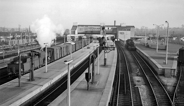
1128:== {{int:filedesc}} == {{Information |Description={{en|1=Banbury Station View SE, towards Oxford and London. This is the main (General) station, on the former GWR Paddington - Birmingham line, so decrepit and a bottleneck it was rebuilt very soon after Na
193:
335:– You must give appropriate credit, provide a link to the license, and indicate if changes were made. You may do so in any reasonable manner, but not in any way that suggests the licensor endorses you or your use.
207:
130:
View southeast towards Oxford and London. This is the main (General) station, on the former GWR Paddington – Birmingham line, so decrepit and a bottleneck it was rebuilt very soon after nationalisation.
731:
876:
715:
565:
521:
723:
430:
83:
1025:
980:
935:
868:
830:
727:
711:
647:
643:
517:
426:
418:
414:
51:
739:
422:
872:
735:
719:
605:
561:
410:
568:"}},"text\/plain":{"en":{"P275":"Creative Commons Attribution-ShareAlike 2.0 Generic"}}}}": -->
171:
742:"}},"text\/plain":{"en":{"P973":"https:\/\/www.geograph.org.uk\/photo\/1750029"}}}}": -->
920:
765:
591:
547:
217:
785:
1165:
252:
1178:
This file contains additional information, probably added from the digital camera or scanner used to create or digitize it.
1222:
342:
502:
1039:
994:
949:
886:
840:
793:
749:
688:
661:
531:
495:
480:
467:
913:
808:
778:
615:
575:
440:
399:
1110:
1105:
42:
298:
1181:
If the file has been modified from its original state, some details may not fully reflect the modified file.
341:– If you remix, transform, or build upon the material, you must distribute your contributions under the
259:
on the
Geograph website for the photographer's contact details. The copyright on this image is owned by
942:"}},"text\/plain":{"en":{"P3575":"116,300 byte"}}}}": -->
433:"}},"text\/plain":{"en":{"P3831":"photographer"}}}}": -->
524:"}},"text\/plain":{"en":{"P6216":"copyrighted"}}}}": -->
654:"}},"text\/plain":{"en":{"P7787":"157 degree"}}}}": -->
1032:"}},"text\/plain":{"en":{"P2049":"640 pixel"}}}}": -->
987:"}},"text\/plain":{"en":{"P2048":"371 pixel"}}}}": -->
91:
879:"}},"text\/plain":{"en":{"P459":"SHA-1"}}}}": -->
815:
800:
487:
295:
8:
239:
1142:
223:
264:
78:
389:
1147:
160:
150:
1049:
1004:
959:
896:
850:
759:
671:
625:
585:
541:
450:
1237:
1121:
244:
256:
1078:
Click on a date/time to view the file as it appeared at that time.
209:
194:
52° 03′ 39.46″ N, 1° 19′ 40.19″ W
139:
66:
383:
Add a one-line explanation of what this file represents
1136:
1156:
1076:
178:
Creative
Commons Attribution Share-alike license 2.0
90:
Commons is a freely licensed media file repository.
592:
Creative
Commons Attribution-ShareAlike 2.0 Generic
566:
Creative
Commons Attribution-ShareAlike 2.0 Generic
56:(640 × 371 pixels, file size: 114 KB, MIME type:
352:https://creativecommons.org/licenses/by-sa/2.0
116:Banbury a railway station 1750029 c8ae428e.jpg
71:
52:Banbury_a_railway_station_1750029_c8ae428e.jpg
740:https:\/\/www.geograph.org.uk\/photo\/1750029
423:https:\/\/www.geograph.org.uk\/profile\/44502
358:Creative Commons Attribution-Share Alike 2.0
276:
166:
135:
113:
156:
145:
14:
1029:
984:
939:
651:
318:– to copy, distribute and transmit the work
1158:The following other wikis use this file:
816:https://www.geograph.org.uk/photo/1750029
488:https://www.geograph.org.uk/profile/44502
902:c809abd1285e55af2f1280c3bf9eae983ee4215b
216:View this and other nearby images on:
1138:The following 2 pages use this file:
102:
1223:Adobe Photoshop Elements 3.0 Windows
263:and is licensed for reuse under the
184:
1069:
299:Attribution-Share Alike 2.0 Generic
287:
282:
267:Attribution-ShareAlike 2.0 license.
13:
1176:
388:
382:
273:
250:
120:
103:
49:
1254:
1183:
387:
662:coordinates of the point of view
644:coordinates of the point of view
373:
329:Under the following conditions:
294:This file is licensed under the
286:
281:
275:
243:
222:
208:
200:
70:
31:
21:
370:
121:
46:No higher resolution available.
1153:
1073:
766:file available on the internet
716:file available on the internet
369:
251:This image was taken from the
26:
1:
36:
1133:
786:Geograph Britain and Ireland
724:Geograph Britain and Ireland
677:52°3'39.460"N, 1°19'40.192"W
496:object of statement has role
427:object of statement has role
395:Items portrayed in this file
235:
199:
7:
1173:
1162:Usage on arz.wikipedia.org
10:
1259:
343:same or compatible license
110:
105:
1229:File change date and time
1070:
16:
794:geograph.org.uk image ID
728:geograph.org.uk image ID
372:
309:
77:This is a file from the
41:
1127:
138:
81:. Information from its
1106:10:02, 23 January 2011
257:this photograph's page
228:52.060961; -1.327831
84:description page there
1203:Horizontal resolution
1232:19:10, 12 March 2010
914:determination method
873:determination method
1211:Vertical resolution
1190:EPSON scanner image
324:– to adapt the work
1143:History of Banbury
468:author name string
415:author name string
1246:
1245:
1154:Global file usage
1131:
1031:
986:
941:
653:
576:copyright license
562:copyright license
381:
272:
271:
255:collection. See
233:
232:
182:
181:
175:
172:Reusing this file
99:
98:
79:Wikimedia Commons
32:Global file usage
1250:
1184:
1118:
1080:
1058:
1013:
968:
923:
918:
818:
813:
809:described at URL
803:
798:
788:
783:
736:described at URL
699:
698:
693:
532:copyright status
518:copyright status
505:
500:
490:
485:
475:
472:
379:
365:
362:
359:
356:
353:
345:as the original.
307:
296:Creative Commons
290:
289:
285:
284:
279:
278:
265:Creative Commons
253:Geograph project
247:
240:
229:
226:
212:
211:
205:
204:
203:
197:
196:
185:
169:
141:
125:
117:
111:
95:
74:
73:
67:
61:
59:
1258:
1257:
1253:
1252:
1251:
1249:
1248:
1247:
1172:
1152:
1148:Howard Cavanagh
1132:
1124:
1116:
1072:
1071:
1068:
1067:
1066:
1065:
1064:
1063:
1062:
1061:
1059:
1056:
1046:
1045:
1044:
1042:
1023:
1022:
1021:
1020:
1019:
1018:
1017:
1016:
1014:
1011:
1001:
1000:
999:
997:
978:
977:
976:
975:
974:
973:
972:
971:
969:
966:
956:
955:
954:
952:
933:
932:
931:
930:
929:
928:
927:
926:
925:
924:
919:
916:
907:
906:
905:
903:
893:
892:
891:
889:
866:
865:
864:
863:
862:
861:
860:
859:
857:
847:
846:
845:
843:
828:
827:
826:
825:
824:
823:
822:
821:
820:
819:
814:
811:
805:
804:
799:
796:
790:
789:
784:
781:
772:
771:
770:
768:
756:
755:
754:
752:
709:
708:
707:
706:
705:
704:
703:
702:
701:
700:
696:
694:
691:
682:
681:
680:
678:
668:
667:
666:
664:
641:
640:
639:
638:
637:
636:
635:
634:
632:
622:
621:
620:
618:
603:
602:
601:
600:
599:
598:
597:
596:
594:
582:
581:
580:
578:
559:
558:
557:
556:
555:
554:
553:
552:
550:
538:
537:
536:
534:
515:
514:
513:
512:
511:
510:
509:
508:
507:
506:
501:
498:
492:
491:
486:
483:
477:
476:
473:
470:
461:
460:
459:
457:
447:
446:
445:
443:
408:
407:
406:
405:
404:
402:
386:
385:
384:
367:
366:
363:
360:
357:
354:
351:
350:
308:
305:
302:
291:
268:
238:
227:
201:
192:
191:
188:Camera location
183:
151:geograph.org.uk
131:
127:Banbury Station
115:
108:
101:
100:
89:
88:
87:is shown below.
63:
57:
55:
48:
47:
12:
11:
5:
1256:
1244:
1243:
1240:
1234:
1233:
1230:
1226:
1225:
1220:
1216:
1215:
1212:
1208:
1207:
1204:
1200:
1199:
1196:
1192:
1191:
1188:
1175:
1171:
1170:
1169:
1168:
1166:هوارد كايڤاناج
1155:
1151:
1150:
1145:
1135:
1130:
1129:
1126:
1122:
1119:
1113:
1108:
1103:
1099:
1098:
1095:
1092:
1089:
1086:
1083:
1075:
1060:
1054:
1052:
1051:
1050:
1048:
1047:
1043:
1038:
1036:
1035:
1034:
1033:
1027:
1015:
1009:
1007:
1006:
1005:
1003:
1002:
998:
993:
991:
990:
989:
988:
982:
970:
964:
962:
961:
960:
958:
957:
953:
948:
946:
945:
944:
943:
937:
912:
911:
910:
909:
908:
904:
901:
899:
898:
897:
895:
894:
890:
885:
883:
882:
881:
880:
878:
874:
870:
858:
855:
853:
852:
851:
849:
848:
844:
839:
837:
836:
835:
834:
832:
807:
806:
792:
791:
777:
776:
775:
774:
773:
769:
764:
762:
761:
760:
758:
757:
753:
750:source of file
748:
746:
745:
744:
743:
741:
737:
733:
729:
725:
721:
717:
713:
712:source of file
687:
686:
685:
684:
683:
679:
676:
674:
673:
672:
670:
669:
665:
660:
658:
657:
656:
655:
649:
645:
633:
630:
628:
627:
626:
624:
623:
619:
614:
612:
611:
610:
609:
607:
595:
590:
588:
587:
586:
584:
583:
579:
574:
572:
571:
570:
569:
567:
563:
551:
546:
544:
543:
542:
540:
539:
535:
530:
528:
527:
526:
525:
523:
519:
494:
493:
479:
478:
474:Ben Brooksbank
466:
465:
464:
463:
462:
458:
455:
453:
452:
451:
449:
448:
444:
439:
437:
436:
435:
434:
432:
428:
424:
420:
416:
412:
403:
398:
396:
393:
392:
391:
390:
378:
377:
374:
371:
349:
348:
347:
346:
336:
327:
326:
325:
319:
312:You are free:
306:Ben Brooksbank
303:
293:
292:
274:
270:
269:
261:Ben Brooksbank
248:
237:
234:
231:
230:
220:
214:
189:
180:
179:
176:
164:
163:
161:Ben Brooksbank
158:
154:
153:
147:
143:
142:
137:
133:
132:
118:
109:
107:
104:
97:
96:
75:
65:
64:
45:
40:
39:
34:
29:
24:
19:
9:
6:
4:
3:
2:
1255:
1241:
1239:
1236:
1235:
1231:
1228:
1227:
1224:
1221:
1219:Software used
1218:
1217:
1213:
1210:
1209:
1205:
1202:
1201:
1197:
1194:
1193:
1189:
1186:
1185:
1182:
1179:
1167:
1164:
1163:
1161:
1160:
1159:
1149:
1146:
1144:
1141:
1140:
1139:
1125:
1120:
1114:
1112:
1109:
1107:
1104:
1101:
1100:
1096:
1093:
1090:
1087:
1084:
1082:
1081:
1079:
1053:
1041:
1037:
1008:
996:
992:
963:
951:
947:
922:
915:
900:
888:
884:
854:
842:
838:
817:
810:
802:
795:
787:
780:
767:
763:
751:
747:
690:
675:
663:
659:
631:24 March 1961
629:
617:
613:
593:
589:
577:
573:
549:
545:
533:
529:
504:
497:
489:
482:
469:
454:
442:
438:
401:
397:
394:
375:
368:
355:CC BY-SA 2.0
344:
340:
337:
334:
331:
330:
328:
323:
320:
317:
314:
313:
311:
310:
304:Attribution:
300:
297:
280:
266:
262:
258:
254:
249:
246:
242:
241:
225:
221:
219:
218:OpenStreetMap
215:
213:
195:
190:
187:
186:
177:
173:
168:
165:
162:
159:
155:
152:
148:
144:
140:24 March 1961
134:
129:
128:
124:
119:
112:
93:
86:
85:
80:
76:
69:
68:
62:
53:
44:
38:
35:
33:
30:
28:
25:
23:
20:
18:
15:
1242:Uncalibrated
1180:
1177:
1157:
1137:
1077:
1074:File history
503:photographer
431:photographer
338:
332:
321:
315:
260:
198:
126:
122:
92:You can help
82:
50:
22:File history
1238:Color space
1195:Orientation
1187:Image title
548:copyrighted
522:copyrighted
339:share alike
333:attribution
114:Description
1134:File usage
1115:640 × 371
1091:Dimensions
856:image/jpeg
841:media type
831:media type
456:some value
167:Permission
58:image/jpeg
27:File usage
1088:Thumbnail
1085:Date/Time
950:data size
936:data size
616:inception
606:inception
236:Licensing
123:English:
1174:Metadata
1117:(114 KB)
965:116,300
887:checksum
869:checksum
779:operator
720:operator
376:Captions
322:to remix
316:to share
301:license.
37:Metadata
1102:current
1097:Comment
801:1750029
732:1750029
689:heading
648:heading
441:creator
411:creator
400:depicts
380:English
106:Summary
54:
1214:78 dpc
1206:78 dpc
1198:Normal
1123:Chevin
995:height
981:height
697:degree
652:degree
206:
157:Author
146:Source
1057:pixel
1040:width
1030:pixel
1026:width
1012:pixel
985:pixel
921:SHA-1
877:SHA-1
149:From
1094:User
1055:640
1010:371
967:byte
940:byte
695:157
364:true
361:true
136:Date
17:File
481:URL
419:URL
917::
812::
797::
782::
692::
499::
484::
471::
174:)
170:(
94:.
60:)
