574:"}},"text\/plain":{"en":{"":"checksum"}}},"{\"value\":\"05f318e58b0c2e663de05eb214cd32547e4b99e8\",\"type\":\"string\"}":{"text\/html":{"en":{"P4092":"05f318e58b0c2e663de05eb214cd32547e4b99e8"}},"text\/plain":{"en":{"P4092":"05f318e58b0c2e663de05eb214cd32547e4b99e8"}}},"{\"value\":{\"entity-type\":\"property\",\"numeric-id\":459,\"id\":\"P459\"},\"type\":\"wikibase-entityid\"}":{"text\/html":{"en":{"":"
498:"}},"text\/plain":{"en":{"":"inception"}}},"{\"value\":{\"time\":\"+2010-07-17T00:00:00Z\",\"timezone\":0,\"before\":0,\"after\":0,\"precision\":11,\"calendarmodel\":\"http:\\\/\\\/www.wikidata.org\\\/entity\\\/Q1985727\"},\"type\":\"time\"}":{"text\/html":{"en":{"P571":"17 July 2010"}},"text\/plain":{"en":{"P571":"17 July 2010"}}}}": -->
43:
258:
570:
269:
99:
536:"}},"text\/plain":{"en":{"":"media type"}}},"{\"value\":\"image\\\/svg+xml\",\"type\":\"string\"}":{"text\/html":{"en":{"P1163":"image\/svg+xml"}},"text\/plain":{"en":{"P1163":"image\/svg+xml"}}}}": -->
578:"}},"text\/plain":{"en":{"":"determination method"}}},"{\"value\":{\"entity-type\":\"item\",\"numeric-id\":13414952,\"id\":\"Q13414952\"},\"type\":\"wikibase-entityid\"}":{"text\/html":{"en":{"P459":"
641:"}},"text\/plain":{"en":{"":"data size"}}},"{\"value\":{\"amount\":\"+1588189\",\"unit\":\"http:\\\/\\\/www.wikidata.org\\\/entity\\\/Q8799\"},\"type\":\"quantity\"}":{"text\/html":{"en":{"P3575":"1,588,189
454:"}},"text\/plain":{"en":{"":"copyright license"}}},"{\"value\":{\"entity-type\":\"item\",\"numeric-id\":14946043,\"id\":\"Q14946043\"},\"type\":\"wikibase-entityid\"}":{"text\/html":{"en":{"P275":"
410:"}},"text\/plain":{"en":{"":"copyright status"}}},"{\"value\":{\"entity-type\":\"item\",\"numeric-id\":50423863,\"id\":\"Q50423863\"},\"type\":\"wikibase-entityid\"}":{"text\/html":{"en":{"P6216":"
731:"}},"text\/plain":{"en":{"":"width"}}},"{\"value\":{\"amount\":\"+1425\",\"unit\":\"http:\\\/\\\/www.wikidata.org\\\/entity\\\/Q355198\"},\"type\":\"quantity\"}":{"text\/html":{"en":{"P2049":"1,425
686:"}},"text\/plain":{"en":{"":"height"}}},"{\"value\":{\"amount\":\"+741\",\"unit\":\"http:\\\/\\\/www.wikidata.org\\\/entity\\\/Q355198\"},\"type\":\"quantity\"}":{"text\/html":{"en":{"P2048":"741
727:
1383:
1513:
1503:
316:– You must give appropriate credit, provide a link to the license, and indicate if changes were made. You may do so in any reasonable manner, but not in any way that suggests the licensor endorses you or your use.
835:, UK with the following information shown: *Administrative borders *Coastline, lakes and rivers *Roads and railways *Urban areas Equirectangular map projection on WGS 84 datum, with N/S stretched
579:
455:
411:
728:
683:
638:
571:
533:
407:
575:
495:
451:
1355:
846:
1652:
73:
69:
65:
61:
458:"}},"text\/plain":{"en":{"P275":"Creative Commons Attribution-ShareAlike 3.0 Unported"}}}}": -->
57:
53:
47:
1458:
356:
247:
110:
82:
1463:
1133:
623:
481:
437:
1418:
1428:
1663:
This file contains additional information, probably added from the digital camera or scanner used to create or digitize it.
323:
742:
697:
652:
589:
543:
421:
1443:
1403:
616:
505:
465:
396:
1488:
1483:
1413:
218:
279:
1666:
If the file has been modified from its original state, some details may not fully reflect the modified file.
1493:
1378:
845:
More than 100 pages use this file. The following list shows the first 100 pages that use this file only. A
1143:
958:
645:"}},"text\/plain":{"en":{"P3575":"1,588,189 byte"}}}}": -->
322:– If you remix, transform, or build upon the material, you must distribute your contributions under the
1448:
735:"}},"text\/plain":{"en":{"P2049":"1,425 pixel"}}}}": -->
414:"}},"text\/plain":{"en":{"P6216":"copyrighted"}}}}": -->
1408:
1393:
690:"}},"text\/plain":{"en":{"P2048":"741 pixel"}}}}": -->
204:
1338:
1138:
1128:
1043:
933:
118:
813:
808:
42:
1398:
582:"}},"text\/plain":{"en":{"P459":"SHA-1"}}}}": -->
1548:
1523:
1008:
1253:
1243:
1218:
1068:
903:
276:
8:
1213:
1168:
893:
1423:
1373:
1348:
1323:
1298:
1173:
1148:
1123:
988:
943:
918:
1328:
1093:
1083:
1063:
1013:
938:
858:
105:
386:
1318:
1283:
1248:
1203:
1098:
978:
968:
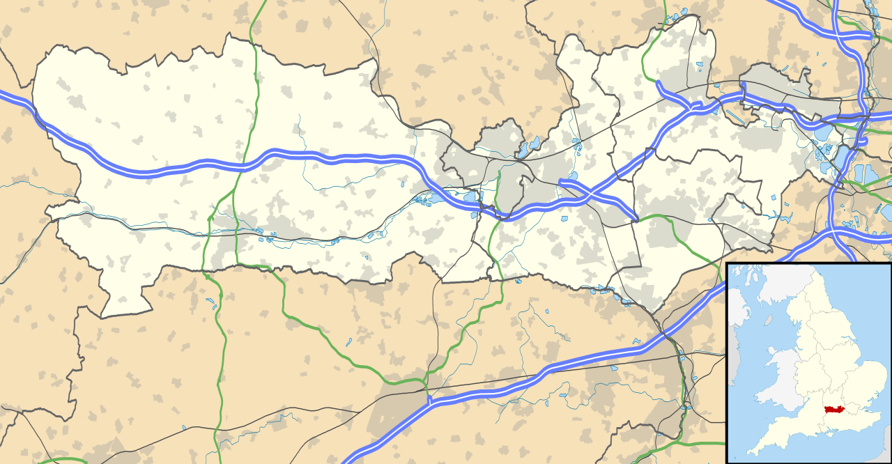
873:
201:
1478:
1473:
1468:
1453:
1438:
1433:
1238:
1208:
1028:
928:
908:
235:
1343:
1178:
1003:
824:
222:
1313:
1308:
1158:
1038:
1303:
983:
752:
707:
662:
599:
553:
515:
475:
431:
1268:
1263:
1183:
878:
853:
164:
Equirectangular map projection on WGS 84 datum, with N/S stretched 160%
1223:
1188:
1153:
1108:
1088:
1048:
993:
923:
868:
144:
1293:
1193:
1073:
1033:
973:
953:
898:
832:
211:
Administrative borders and coastline data from
Boundary-Line product.
1578:
1333:
1288:
1273:
1118:
1113:
1078:
1058:
1053:
963:
913:
863:
781:
Click on a date/time to view the file as it appeared at that time.
1573:
287:
Contains
Ordnance Survey data © Crown copyright and database right
1233:
1163:
1023:
998:
948:
888:
1643:
1638:
1538:
1533:
1628:
1613:
1278:
1258:
1228:
1103:
1018:
883:
1198:
87:(SVG file, nominally 1,425 × 741 pixels, file size: 1.51 MB)
190:
93:
1588:
1583:
1553:
380:
Add a one-line explanation of what this file represents
1633:
1623:
1603:
1598:
1563:
1558:
843:
1618:
1608:
1593:
1543:
1364:
779:
482:
Creative
Commons Attribution-ShareAlike 3.0 Unported
456:
Creative
Commons Attribution-ShareAlike 3.0 Unported
117:
Commons is a freely licensed media file repository.
1384:كأس العالم لاتحاد الجمعيات المستقلة لكرة القدم 2018
1568:
1514:টেমপ্লেট:অবস্থান মানচিত্র United Kingdom Berkshire
214:All other geographic data from Meridian 2 product.
1524:Plantilya:Location map United Kingdom Berkshire
333:https://creativecommons.org/licenses/by-sa/3.0
98:
339:Creative Commons Attribution-Share Alike 3.0
257:
242:
186:
135:
352:
231:
196:
14:
1549:Plantilla:Mapa de localización de Berkshire
732:
687:
642:
299:– to copy, distribute and transmit the work
147:, UK with the following information shown:
46:Size of this PNG preview of this SVG file:
1379:قالب:Location map United Kingdom Berkshire
357:File:Berkshire UK district map (blank).svg
1366:The following other wikis use this file:
605:05f318e58b0c2e663de05eb214cd32547e4b99e8
1134:Lardon Chase, the Holies and Lough Down
129:
280:Attribution-Share Alike 3.0 Unported
238:, created using Ordnance Survey data
772:
268:
263:
13:
1661:
831:{{Information |Description=Map of
385:
379:
254:
130:
80:
1695:
1668:
384:
1504:Шаблон:ПК Великобритания Бъркшър
370:
310:Under the following conditions:
275:This file is licensed under the
267:
262:
256:
97:
31:
21:
367:
1361:
776:
366:
26:
1:
138:Berkshire UK location map.svg
36:
840:
392:Items portrayed in this file
7:
1658:
1520:Usage on ceb.wikipedia.org
1390:Usage on azb.wikipedia.org
1144:List of places in Berkshire
959:Civil parishes in Berkshire
154:Coastline, lakes and rivers
10:
1700:
1530:Usage on es.wikipedia.org
1510:Usage on bn.wikipedia.org
1500:Usage on bg.wikipedia.org
1370:Usage on ar.wikipedia.org
324:same or compatible license
132:
773:
16:
809:17:56, 26 September 2010
369:
290:
219:England location map.svg
104:This is a file from the
41:
1339:Winterbourne, Berkshire
1139:Legoland Windsor Resort
1129:Langley railway station
1044:First Battle of Newbury
934:Burnham railway station
830:
189:
108:. Information from its
1579:Cranbourne (Berkshire)
151:Administrative borders
111:description page there
1574:Sandhurst (Berkshire)
1009:Donnington, Berkshire
1254:Streatley, Berkshire
1244:Southcote, Berkshire
1219:Sandhurst, Berkshire
1069:Hermitage, Berkshire
904:Bradfield, Berkshire
617:determination method
576:determination method
70:2,560 × 1,331 pixels
1644:Arborfield Garrison
1639:Riseley (Berkshire)
1539:Castillo de Windsor
1534:Windsor (Berkshire)
1214:RAF Greenham Common
1169:Monkey Island, Bray
894:Basildon, Berkshire
305:– to adapt the work
217:Inset derived from
167:Geographic limits:
52:Other resolutions:
1629:Hurley (Berkshire)
1614:Horton (Berkshire)
1349:Woodley, Berkshire
1324:Windsor, Berkshire
1299:Twyford, Berkshire
1174:Newbury, Berkshire
1149:Magna Carta Island
1124:Langley, Berkshire
989:Compton, Berkshire
944:Caversham, Reading
919:Broadmoor Hospital
157:Roads and railways
74:1,425 × 741 pixels
66:1,280 × 666 pixels
62:1,024 × 532 pixels
1687:
1686:
1653:more global usage
1362:Global file usage
1329:Windsor Guildhall
1094:Hurley, Berkshire
1084:Horton, Berkshire
1064:Hampstead Norreys
1014:Donnington Castle
939:Calcot, Berkshire
859:Aldermaston Court
838:
734:
689:
644:
466:copyright license
452:copyright license
378:
363:
362:
251:
248:Reusing this file
126:
125:
106:Wikimedia Commons
32:Global file usage
1691:
1669:
1459:ساندهورست، برکشر
1319:Whitley, Reading
1284:Three Mile Cross
1249:Speen, Berkshire
1204:Purley on Thames
1099:Hurst, Berkshire
979:Combe, Berkshire
969:Coley, Berkshire
874:Ascot, Berkshire
821:
783:
761:
716:
671:
626:
621:
422:copyright status
408:copyright status
376:
346:
343:
340:
337:
334:
326:as the original.
288:
277:Creative Commons
271:
270:
266:
265:
260:
259:
245:
192:
139:
133:
122:
101:
100:
94:
88:
77:
58:640 × 333 pixels
54:320 × 166 pixels
48:800 × 416 pixels
1699:
1698:
1694:
1693:
1692:
1690:
1689:
1688:
1657:
1464:توایفورد، برکشر
1419:والتام سن لارنس
1360:
1239:South Hill Park
1209:RAF Aldermaston
1029:Eton, Berkshire
929:Burchetts Green
909:Bray, Berkshire
839:
827:
819:
775:
774:
771:
770:
769:
768:
767:
766:
765:
764:
762:
759:
749:
748:
747:
745:
726:
725:
724:
723:
722:
721:
720:
719:
717:
714:
704:
703:
702:
700:
681:
680:
679:
678:
677:
676:
675:
674:
672:
669:
659:
658:
657:
655:
636:
635:
634:
633:
632:
631:
630:
629:
628:
627:
622:
619:
610:
609:
608:
606:
596:
595:
594:
592:
569:
568:
567:
566:
565:
564:
563:
562:
560:
550:
549:
548:
546:
531:
530:
529:
528:
527:
526:
525:
524:
522:
512:
511:
510:
508:
493:
492:
491:
490:
489:
488:
487:
486:
484:
472:
471:
470:
468:
449:
448:
447:
446:
445:
444:
443:
442:
440:
428:
427:
426:
424:
405:
404:
403:
402:
401:
399:
383:
382:
381:
364:
348:
347:
344:
341:
338:
335:
332:
331:
289:
286:
283:
272:
202:Ordnance Survey
137:
128:
127:
116:
115:
114:is shown below.
90:
86:
79:
78:
51:
12:
11:
5:
1697:
1685:
1684:
1681:
1677:
1676:
1673:
1660:
1655:of this file.
1649:
1648:
1647:
1646:
1641:
1636:
1631:
1626:
1621:
1616:
1611:
1606:
1601:
1596:
1591:
1586:
1581:
1576:
1571:
1566:
1561:
1556:
1551:
1546:
1541:
1536:
1528:
1527:
1526:
1518:
1517:
1516:
1508:
1507:
1506:
1498:
1497:
1496:
1491:
1486:
1481:
1476:
1471:
1466:
1461:
1456:
1451:
1446:
1441:
1436:
1431:
1429:نیوبوری، برکشر
1426:
1421:
1416:
1411:
1406:
1401:
1396:
1388:
1387:
1386:
1381:
1376:
1363:
1358:to this file.
1352:
1351:
1346:
1344:Wokefield Park
1341:
1336:
1331:
1326:
1321:
1316:
1311:
1306:
1301:
1296:
1291:
1286:
1281:
1276:
1271:
1266:
1261:
1256:
1251:
1246:
1241:
1236:
1231:
1226:
1221:
1216:
1211:
1206:
1201:
1196:
1191:
1186:
1181:
1179:Newbury Castle
1176:
1171:
1166:
1161:
1156:
1151:
1146:
1141:
1136:
1131:
1126:
1121:
1116:
1111:
1106:
1101:
1096:
1091:
1086:
1081:
1076:
1071:
1066:
1061:
1056:
1051:
1046:
1041:
1036:
1031:
1026:
1021:
1016:
1011:
1006:
1004:Ditton, Slough
1001:
996:
991:
986:
981:
976:
971:
966:
961:
956:
951:
946:
941:
936:
931:
926:
921:
916:
911:
906:
901:
896:
891:
886:
881:
876:
871:
866:
861:
856:
849:is available.
842:
837:
836:
829:
825:
822:
816:
811:
806:
802:
801:
798:
795:
792:
789:
786:
778:
763:
757:
755:
754:
753:
751:
750:
746:
741:
739:
738:
737:
736:
730:
718:
712:
710:
709:
708:
706:
705:
701:
696:
694:
693:
692:
691:
685:
673:
667:
665:
664:
663:
661:
660:
656:
651:
649:
648:
647:
646:
640:
615:
614:
613:
612:
611:
607:
604:
602:
601:
600:
598:
597:
593:
588:
586:
585:
584:
583:
581:
577:
573:
561:
558:
556:
555:
554:
552:
551:
547:
542:
540:
539:
538:
537:
535:
523:
520:
518:
517:
516:
514:
513:
509:
504:
502:
501:
500:
499:
497:
485:
480:
478:
477:
476:
474:
473:
469:
464:
462:
461:
460:
459:
457:
453:
441:
436:
434:
433:
432:
430:
429:
425:
420:
418:
417:
416:
415:
413:
409:
400:
395:
393:
390:
389:
388:
387:
375:
374:
371:
368:
361:
360:
354:
353:Other versions
350:
349:
330:
329:
328:
327:
317:
308:
307:
306:
300:
293:You are free:
284:
274:
273:
255:
252:
240:
239:
233:
229:
228:
227:
226:
215:
212:
198:
194:
193:
188:
184:
183:
182:
181:
178:
175:
172:
162:
161:
158:
155:
152:
140:
131:
124:
123:
102:
92:
91:
45:
40:
39:
34:
29:
24:
19:
9:
6:
4:
3:
2:
1696:
1682:
1679:
1678:
1674:
1671:
1670:
1667:
1664:
1656:
1654:
1645:
1642:
1640:
1637:
1635:
1632:
1630:
1627:
1625:
1622:
1620:
1617:
1615:
1612:
1610:
1607:
1605:
1602:
1600:
1597:
1595:
1592:
1590:
1587:
1585:
1582:
1580:
1577:
1575:
1572:
1570:
1567:
1565:
1562:
1560:
1557:
1555:
1552:
1550:
1547:
1545:
1542:
1540:
1537:
1535:
1532:
1531:
1529:
1525:
1522:
1521:
1519:
1515:
1512:
1511:
1509:
1505:
1502:
1501:
1499:
1495:
1492:
1490:
1487:
1485:
1482:
1480:
1477:
1475:
1472:
1470:
1467:
1465:
1462:
1460:
1457:
1455:
1452:
1450:
1447:
1445:
1444:لانقلی، برکشر
1442:
1440:
1437:
1435:
1432:
1430:
1427:
1425:
1422:
1420:
1417:
1415:
1412:
1410:
1407:
1405:
1404:وینزر، بارکشر
1402:
1400:
1397:
1395:
1392:
1391:
1389:
1385:
1382:
1380:
1377:
1375:
1372:
1371:
1369:
1368:
1367:
1359:
1357:
1350:
1347:
1345:
1342:
1340:
1337:
1335:
1332:
1330:
1327:
1325:
1322:
1320:
1317:
1315:
1314:White Waltham
1312:
1310:
1309:Upton, Slough
1307:
1305:
1302:
1300:
1297:
1295:
1292:
1290:
1287:
1285:
1282:
1280:
1277:
1275:
1272:
1270:
1267:
1265:
1262:
1260:
1257:
1255:
1252:
1250:
1247:
1245:
1242:
1240:
1237:
1235:
1232:
1230:
1227:
1225:
1222:
1220:
1217:
1215:
1212:
1210:
1207:
1205:
1202:
1200:
1197:
1195:
1192:
1190:
1187:
1185:
1182:
1180:
1177:
1175:
1172:
1170:
1167:
1165:
1162:
1160:
1159:Martins Heron
1157:
1155:
1152:
1150:
1147:
1145:
1142:
1140:
1137:
1135:
1132:
1130:
1127:
1125:
1122:
1120:
1117:
1115:
1112:
1110:
1107:
1105:
1102:
1100:
1097:
1095:
1092:
1090:
1087:
1085:
1082:
1080:
1077:
1075:
1072:
1070:
1067:
1065:
1062:
1060:
1057:
1055:
1052:
1050:
1047:
1045:
1042:
1040:
1039:Finchampstead
1037:
1035:
1032:
1030:
1027:
1025:
1022:
1020:
1017:
1015:
1012:
1010:
1007:
1005:
1002:
1000:
997:
995:
992:
990:
987:
985:
982:
980:
977:
975:
972:
970:
967:
965:
962:
960:
957:
955:
952:
950:
947:
945:
942:
940:
937:
935:
932:
930:
927:
925:
922:
920:
917:
915:
912:
910:
907:
905:
902:
900:
897:
895:
892:
890:
887:
885:
882:
880:
877:
875:
872:
870:
867:
865:
862:
860:
857:
855:
852:
851:
850:
848:
834:
828:
823:
817:
815:
812:
810:
807:
804:
803:
799:
796:
793:
790:
787:
785:
784:
782:
756:
744:
740:
711:
699:
695:
666:
654:
650:
625:
618:
603:
591:
587:
559:image/svg+xml
557:
545:
541:
519:
507:
503:
483:
479:
467:
463:
439:
435:
423:
419:
398:
394:
391:
372:
365:
358:
355:
351:
336:CC BY-SA 3.0
325:
321:
318:
315:
312:
311:
309:
304:
301:
298:
295:
294:
292:
291:
285:Attribution:
281:
278:
261:
253:
249:
244:
241:
237:
234:
230:
224:
220:
216:
213:
210:
209:
208:
206:
203:
199:
195:
185:
180:South: 51.21N
179:
177:North: 51.59N
176:
173:
170:
169:
168:
165:
159:
156:
153:
150:
149:
148:
146:
141:
134:
120:
113:
112:
107:
103:
96:
95:
89:
84:
83:Original file
75:
71:
67:
63:
59:
55:
49:
44:
38:
35:
33:
30:
28:
25:
23:
20:
18:
15:
1665:
1662:
1650:
1489:ایرلی، برکشر
1484:ایست قارستون
1414:وودلی، برکشر
1365:
1353:
1304:Ufton Nervet
984:Combe Gibbet
844:
818:1,425 × 741
780:
777:File history
521:17 July 2010
319:
313:
302:
296:
200:
191:17 July 2010
166:
163:
142:
119:You can help
109:
81:
22:File history
1589:North Ascot
1494:اتون، برکشر
1269:Sunningdale
1264:Sulhamstead
1184:Old Windsor
879:Ashampstead
854:Aldermaston
438:copyrighted
412:copyrighted
359:- Blank map
320:share alike
314:attribution
174:East: 0.46W
171:West: 1.63W
160:Urban areas
136:Description
1584:Crowthorne
1554:Bucklebury
1356:more links
1224:Sindlesham
1189:Pangbourne
1154:Maidenhead
1109:Katesgrove
1089:Hungerford
1049:Fords Farm
994:Crowthorne
924:Bucklebury
869:Arborfield
841:File usage
794:Dimensions
668:1,588,189
544:media type
534:media type
243:Permission
27:File usage
1634:Wraysbury
1624:Broomhall
1604:Cheapside
1599:Eton Wick
1564:Wokingham
1559:Bracknell
1449:کینتبوری
1409:ووکینقهام
1394:هانقرفورد
1294:Tilehurst
1194:Pingewood
1074:Holybrook
1034:Eton Wick
974:Colnbrook
954:Chieveley
899:Bracknell
847:full list
833:Berkshire
826:Nilfanion
820:(1.51 MB)
791:Thumbnail
788:Date/Time
653:data size
639:data size
506:inception
496:inception
236:Nilfanion
145:Berkshire
1659:Metadata
1399:وینکفیلد
1334:Winnersh
1289:Tidmarsh
1274:Thatcham
1119:Lambourn
1114:Kintbury
1079:Holyport
1059:Greenham
1054:Frogmore
964:Cold Ash
914:Britwell
864:Aldworth
590:checksum
572:checksum
373:Captions
303:to remix
297:to share
282:license.
223:Spischot
205:OpenData
37:Metadata
1619:Cookham
1609:Fifield
1594:Datchet
1544:Reading
1424:وارقراو
1374:باركشير
1234:Sonning
1164:Midgham
1024:Enborne
999:Datchet
949:Chalvey
889:Barkham
805:current
800:Comment
397:depicts
377:English
143:Map of
85:
1680:Height
1479:براکنل
1474:بیسهام
1469:تاچهام
1454:سانینق
1439:میدقام
1434:میدنهد
1279:Theale
1259:Sulham
1229:Slough
1104:Inkpen
1019:Earley
884:Bagnor
758:1,425
698:height
684:height
232:Author
197:Source
1672:Width
1651:View
1569:Ascot
1354:View
1199:Poyle
760:pixel
743:width
733:pixel
729:width
715:pixel
688:pixel
624:SHA-1
580:SHA-1
1675:1425
797:User
713:741
670:byte
643:byte
345:true
342:true
187:Date
17:File
1683:741
221:by
620::
207:.
72:|
68:|
64:|
60:|
56:|
50:.
250:)
246:(
225:.
121:.
76:.

.svg)