683:"}},"text\/plain":{"en":{"":"coordinates of the point of view"}}},"{\"value\":{\"latitude\":55.774111,\"longitude\":-2.011451,\"altitude\":null,\"precision\":1.0e-6,\"globe\":\"http:\\\/\\\/www.wikidata.org\\\/entity\\\/Q2\"},\"type\":\"globecoordinate\"}":{"text\/html":{"en":{"P1259":"55\u00b046'26.800"N, 2\u00b00'41.224"W"}},"text\/plain":{"en":{"P1259":"55\u00b046'26.800\"N, 2\u00b00'41.224\"W"}}},"{\"value\":{\"entity-type\":\"property\",\"numeric-id\":7787,\"id\":\"P7787\"},\"type\":\"wikibase-entityid\"}":{"text\/html":{"en":{"":"
908:"}},"text\/plain":{"en":{"":"checksum"}}},"{\"value\":\"6f183d283a186fd6a9e2253a007a6208bb692f8e\",\"type\":\"string\"}":{"text\/html":{"en":{"P4092":"6f183d283a186fd6a9e2253a007a6208bb692f8e"}},"text\/plain":{"en":{"P4092":"6f183d283a186fd6a9e2253a007a6208bb692f8e"}}},"{\"value\":{\"entity-type\":\"property\",\"numeric-id\":459,\"id\":\"P459\"},\"type\":\"wikibase-entityid\"}":{"text\/html":{"en":{"":"
454:"}},"text\/plain":{"en":{"":"author name string"}}},"{\"value\":\"Ben Brooksbank\",\"type\":\"string\"}":{"text\/html":{"en":{"P2093":"Ben Brooksbank"}},"text\/plain":{"en":{"P2093":"Ben Brooksbank"}}},"{\"value\":{\"entity-type\":\"property\",\"numeric-id\":2699,\"id\":\"P2699\"},\"type\":\"wikibase-entityid\"}":{"text\/html":{"en":{"":"
645:"}},"text\/plain":{"en":{"":"inception"}}},"{\"value\":{\"time\":\"+1970-03-24T00:00:00Z\",\"timezone\":0,\"before\":0,\"after\":0,\"precision\":11,\"calendarmodel\":\"http:\\\/\\\/www.wikidata.org\\\/entity\\\/Q1985727\"},\"type\":\"time\"}":{"text\/html":{"en":{"P571":"24 March 1970"}},"text\/plain":{"en":{"P571":"24 March 1970"}}}}": -->
747:
247:
239:
904:
282:
320:
325:
67:
462:"}},"text\/plain":{"en":{"P2699":"https:\/\/www.geograph.org.uk\/profile\/44502"}}},"{\"value\":{\"entity-type\":\"property\",\"numeric-id\":3831,\"id\":\"P3831\"},\"type\":\"wikibase-entityid\"}":{"text\/html":{"en":{"":"
755:"}},"text\/plain":{"en":{"P7482":"file available on the internet"}}},"{\"value\":{\"entity-type\":\"property\",\"numeric-id\":137,\"id\":\"P137\"},\"type\":\"wikibase-entityid\"}":{"text\/html":{"en":{"":"
763:"}},"text\/plain":{"en":{"P137":"Geograph Britain and Ireland"}}},"{\"value\":{\"entity-type\":\"property\",\"numeric-id\":7384,\"id\":\"P7384\"},\"type\":\"wikibase-entityid\"}":{"text\/html":{"en":{"":"
466:"}},"text\/plain":{"en":{"":"object of statement has role"}}},"{\"value\":{\"entity-type\":\"item\",\"numeric-id\":33231,\"id\":\"Q33231\"},\"type\":\"wikibase-entityid\"}":{"text\/html":{"en":{"P3831":"
912:"}},"text\/plain":{"en":{"":"determination method"}}},"{\"value\":{\"entity-type\":\"item\",\"numeric-id\":13414952,\"id\":\"Q13414952\"},\"type\":\"wikibase-entityid\"}":{"text\/html":{"en":{"P459":"
870:"}},"text\/plain":{"en":{"":"media type"}}},"{\"value\":\"image\\\/jpeg\",\"type\":\"string\"}":{"text\/html":{"en":{"P1163":"image\/jpeg"}},"text\/plain":{"en":{"P1163":"image\/jpeg"}}}}": -->
601:"}},"text\/plain":{"en":{"":"copyright license"}}},"{\"value\":{\"entity-type\":\"item\",\"numeric-id\":19068220,\"id\":\"Q19068220\"},\"type\":\"wikibase-entityid\"}":{"text\/html":{"en":{"P275":"
557:"}},"text\/plain":{"en":{"":"copyright status"}}},"{\"value\":{\"entity-type\":\"item\",\"numeric-id\":50423863,\"id\":\"Q50423863\"},\"type\":\"wikibase-entityid\"}":{"text\/html":{"en":{"P6216":"
751:"}},"text\/plain":{"en":{"":"source of file"}}},"{\"value\":{\"entity-type\":\"item\",\"numeric-id\":74228490,\"id\":\"Q74228490\"},\"type\":\"wikibase-entityid\"}":{"text\/html":{"en":{"P7482":"
975:"}},"text\/plain":{"en":{"":"data size"}}},"{\"value\":{\"amount\":\"+124446\",\"unit\":\"http:\\\/\\\/www.wikidata.org\\\/entity\\\/Q8799\"},\"type\":\"quantity\"}":{"text\/html":{"en":{"P3575":"124,446
1020:"}},"text\/plain":{"en":{"":"height"}}},"{\"value\":{\"amount\":\"+368\",\"unit\":\"http:\\\/\\\/www.wikidata.org\\\/entity\\\/Q355198\"},\"type\":\"quantity\"}":{"text\/html":{"en":{"P2048":"368
759:"}},"text\/plain":{"en":{"":"operator"}}},"{\"value\":{\"entity-type\":\"item\",\"numeric-id\":1503119,\"id\":\"Q1503119\"},\"type\":\"wikibase-entityid\"}":{"text\/html":{"en":{"P137":"
687:"}},"text\/plain":{"en":{"":"heading"}}},"{\"value\":{\"amount\":\"+202\",\"unit\":\"http:\\\/\\\/www.wikidata.org\\\/entity\\\/Q28390\"},\"type\":\"quantity\"}":{"text\/html":{"en":{"P7787":"202
1065:"}},"text\/plain":{"en":{"":"width"}}},"{\"value\":{\"amount\":\"+640\",\"unit\":\"http:\\\/\\\/www.wikidata.org\\\/entity\\\/Q355198\"},\"type\":\"quantity\"}":{"text\/html":{"en":{"P2049":"640
771:"}},"text\/plain":{"en":{"P7384":"1864410"}}},"{\"value\":{\"entity-type\":\"property\",\"numeric-id\":973,\"id\":\"P973\"},\"type\":\"wikibase-entityid\"}":{"text\/html":{"en":{"":"
450:"}},"text\/plain":{"en":{"":"creator"}}},"{\"value\":{\"entity-type\":\"property\",\"numeric-id\":2093,\"id\":\"P2093\"},\"type\":\"wikibase-entityid\"}":{"text\/html":{"en":{"":"
1061:
641:
767:"}},"text\/plain":{"en":{"":"geograph.org.uk image ID"}}},"{\"value\":\"1864410\",\"type\":\"string\"}":{"text\/html":{"en":{"P7384":"
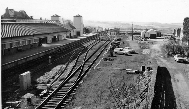
1165:== {{int:filedesc}} == {{Information |Description={{en|1=Berwick-upon-Tweed Station}} View SW, towards Newcastle; ex-NER East Coast Main Line, Newcastle - Edinburgh. The Royal Border Bridge is visible in the centre of the scene and the remnant of Berwick
230:
372:– You must give appropriate credit, provide a link to the license, and indicate if changes were made. You may do so in any reasonable manner, but not in any way that suggests the licensor endorses you or your use.
244:
78:
768:
913:
752:
602:
558:
46:
760:
467:
1062:
1017:
972:
905:
867:
764:
748:
684:
680:
554:
463:
455:
451:
776:
459:
909:
772:
756:
642:
598:
447:
605:"}},"text\/plain":{"en":{"P275":"Creative Commons Attribution-ShareAlike 2.0 Generic"}}}}": -->
167:
779:"}},"text\/plain":{"en":{"P973":"https:\/\/www.geograph.org.uk\/photo\/1864410"}}}}": -->
957:
802:
628:
584:
254:
822:
289:
1190:
This file contains additional information, probably added from the digital camera or scanner used to create or digitize it.
1234:
379:
539:
1076:
1031:
986:
923:
877:
830:
786:
725:
698:
568:
532:
517:
504:
1179:
950:
845:
815:
652:
612:
477:
436:
1147:
1142:
37:
335:
1193:
If the file has been modified from its original state, some details may not fully reflect the modified file.
378:– If you remix, transform, or build upon the material, you must distribute your contributions under the
296:
on the
Geograph website for the photographer's contact details. The copyright on this image is owned by
979:"}},"text\/plain":{"en":{"P3575":"124,446 byte"}}}}": -->
470:"}},"text\/plain":{"en":{"P3831":"photographer"}}}}": -->
561:"}},"text\/plain":{"en":{"P6216":"copyrighted"}}}}": -->
691:"}},"text\/plain":{"en":{"P7787":"202 degree"}}}}": -->
1069:"}},"text\/plain":{"en":{"P2049":"640 pixel"}}}}": -->
1024:"}},"text\/plain":{"en":{"P2048":"368 pixel"}}}}": -->
86:
199:
916:"}},"text\/plain":{"en":{"P459":"SHA-1"}}}}": -->
852:
837:
524:
332:
183:
8:
276:
260:
301:
73:
426:
156:
146:
1086:
1041:
996:
933:
887:
796:
708:
662:
622:
578:
487:
1249:
1158:
281:
293:
1115:
Click on a date/time to view the file as it appeared at that time.
246:
231:
55° 46′ 26.8″ N, 2° 00′ 41.22″ W
135:
61:
420:
Add a one-line explanation of what this file represents
1173:
1113:
174:
Creative
Commons Attribution Share-alike license 2.0
85:
Commons is a freely licensed media file repository.
629:
Creative
Commons Attribution-ShareAlike 2.0 Generic
603:
Creative
Commons Attribution-ShareAlike 2.0 Generic
111:Berwick on tweed train station1864410 338dec46.jpg
47:Berwick_on_tweed_train_station1864410_338dec46.jpg
51:(640 × 368 pixels, file size: 122 KB, MIME type:
389:https://creativecommons.org/licenses/by-sa/2.0
126:hydraulic luggage-lifts - a relative novelty).
66:
777:https:\/\/www.geograph.org.uk\/photo\/1864410
460:https:\/\/www.geograph.org.uk\/profile\/44502
395:Creative Commons Attribution-Share Alike 2.0
313:
162:
131:
108:
152:
141:
14:
1066:
1021:
976:
688:
355:– to copy, distribute and transmit the work
853:https://www.geograph.org.uk/photo/1864410
525:https://www.geograph.org.uk/profile/44502
939:6f183d283a186fd6a9e2253a007a6208bb692f8e
253:View this and other nearby images on:
206:
97:
1235:Adobe Photoshop Elements 3.0 Windows
300:and is licensed for reuse under the
221:
1175:The following page uses this file:
1106:
336:Attribution-Share Alike 2.0 Generic
324:
319:
304:Attribution-ShareAlike 2.0 license.
13:
1188:
1180:Berwick-upon-Tweed railway station
425:
419:
310:
287:
115:
98:
44:
1266:
1195:
424:
699:coordinates of the point of view
681:coordinates of the point of view
410:
366:Under the following conditions:
331:This file is licensed under the
323:
318:
312:
280:
259:
245:
237:
65:
21:
407:
116:
41:No higher resolution available.
1110:
803:file available on the internet
753:file available on the internet
406:
288:This image was taken from the
26:
1:
31:
1170:
823:Geograph Britain and Ireland
761:Geograph Britain and Ireland
714:55°46'26.800"N, 2°0'41.224"W
533:object of statement has role
464:object of statement has role
432:Items portrayed in this file
272:
236:
7:
1185:
212:Ben Brooksbank /
193:Ben Brooksbank /
122:Berwick-upon-Tweed Station.
10:
1271:
380:same or compatible license
214:Berwick-upon-Tweed Station
195:Berwick-upon-Tweed Station
105:
100:
1241:File change date and time
1107:
16:
831:geograph.org.uk image ID
765:geograph.org.uk image ID
409:
346:
72:This is a file from the
36:
1164:
184:required by the license
134:
76:. Information from its
294:this photograph's page
265:55.774111; -2.011451
79:description page there
1215:Horizontal resolution
951:determination method
910:determination method
1223:Vertical resolution
1202:EPSON scanner image
361:– to adapt the work
1244:17:35, 18 May 2010
1143:14:51, 27 May 2010
505:author name string
452:author name string
1258:
1257:
1168:
1068:
1023:
978:
690:
613:copyright license
599:copyright license
418:
309:
308:
292:collection. See
270:
269:
219:
218:
187:
171:
168:Reusing this file
94:
93:
74:Wikimedia Commons
1262:
1196:
1155:
1117:
1095:
1050:
1005:
960:
955:
855:
850:
846:described at URL
840:
835:
825:
820:
773:described at URL
736:
735:
730:
569:copyright status
555:copyright status
542:
537:
527:
522:
512:
509:
416:
402:
399:
396:
393:
390:
382:as the original.
344:
333:Creative Commons
327:
326:
322:
321:
316:
315:
302:Creative Commons
290:Geograph project
284:
277:
266:
263:
249:
248:
242:
241:
240:
234:
233:
222:
181:
165:
137:
120:
112:
106:
90:
69:
68:
62:
56:
54:
1270:
1269:
1265:
1264:
1263:
1261:
1260:
1259:
1184:
1169:
1161:
1153:
1109:
1108:
1105:
1104:
1103:
1102:
1101:
1100:
1099:
1098:
1096:
1093:
1083:
1082:
1081:
1079:
1060:
1059:
1058:
1057:
1056:
1055:
1054:
1053:
1051:
1048:
1038:
1037:
1036:
1034:
1015:
1014:
1013:
1012:
1011:
1010:
1009:
1008:
1006:
1003:
993:
992:
991:
989:
970:
969:
968:
967:
966:
965:
964:
963:
962:
961:
956:
953:
944:
943:
942:
940:
930:
929:
928:
926:
903:
902:
901:
900:
899:
898:
897:
896:
894:
884:
883:
882:
880:
865:
864:
863:
862:
861:
860:
859:
858:
857:
856:
851:
848:
842:
841:
836:
833:
827:
826:
821:
818:
809:
808:
807:
805:
793:
792:
791:
789:
746:
745:
744:
743:
742:
741:
740:
739:
738:
737:
733:
731:
728:
719:
718:
717:
715:
705:
704:
703:
701:
678:
677:
676:
675:
674:
673:
672:
671:
669:
659:
658:
657:
655:
640:
639:
638:
637:
636:
635:
634:
633:
631:
619:
618:
617:
615:
596:
595:
594:
593:
592:
591:
590:
589:
587:
575:
574:
573:
571:
552:
551:
550:
549:
548:
547:
546:
545:
544:
543:
538:
535:
529:
528:
523:
520:
514:
513:
510:
507:
498:
497:
496:
494:
484:
483:
482:
480:
445:
444:
443:
442:
441:
439:
423:
422:
421:
404:
403:
400:
397:
394:
391:
388:
387:
345:
342:
339:
328:
305:
275:
264:
238:
229:
228:
225:Camera location
220:
209:
202:
190:
147:geograph.org.uk
127:
110:
103:
96:
95:
84:
83:
82:is shown below.
58:
52:
50:
43:
42:
12:
11:
5:
1268:
1256:
1255:
1252:
1246:
1245:
1242:
1238:
1237:
1232:
1228:
1227:
1224:
1220:
1219:
1216:
1212:
1211:
1208:
1204:
1203:
1200:
1187:
1183:
1182:
1172:
1167:
1166:
1163:
1159:
1156:
1150:
1145:
1140:
1136:
1135:
1132:
1129:
1126:
1123:
1120:
1112:
1097:
1091:
1089:
1088:
1087:
1085:
1084:
1080:
1075:
1073:
1072:
1071:
1070:
1064:
1052:
1046:
1044:
1043:
1042:
1040:
1039:
1035:
1030:
1028:
1027:
1026:
1025:
1019:
1007:
1001:
999:
998:
997:
995:
994:
990:
985:
983:
982:
981:
980:
974:
949:
948:
947:
946:
945:
941:
938:
936:
935:
934:
932:
931:
927:
922:
920:
919:
918:
917:
915:
911:
907:
895:
892:
890:
889:
888:
886:
885:
881:
876:
874:
873:
872:
871:
869:
844:
843:
829:
828:
814:
813:
812:
811:
810:
806:
801:
799:
798:
797:
795:
794:
790:
787:source of file
785:
783:
782:
781:
780:
778:
774:
770:
766:
762:
758:
754:
750:
749:source of file
724:
723:
722:
721:
720:
716:
713:
711:
710:
709:
707:
706:
702:
697:
695:
694:
693:
692:
686:
682:
670:
667:
665:
664:
663:
661:
660:
656:
651:
649:
648:
647:
646:
644:
632:
627:
625:
624:
623:
621:
620:
616:
611:
609:
608:
607:
606:
604:
600:
588:
583:
581:
580:
579:
577:
576:
572:
567:
565:
564:
563:
562:
560:
556:
531:
530:
516:
515:
511:Ben Brooksbank
503:
502:
501:
500:
499:
495:
492:
490:
489:
488:
486:
485:
481:
476:
474:
473:
472:
471:
469:
465:
461:
457:
453:
449:
440:
435:
433:
430:
429:
428:
427:
415:
414:
411:
408:
386:
385:
384:
383:
373:
364:
363:
362:
356:
349:You are free:
343:Ben Brooksbank
340:
330:
329:
311:
307:
306:
298:Ben Brooksbank
285:
274:
271:
268:
267:
257:
251:
226:
217:
216:
210:
207:
204:
203:
198:
191:
188:
176:
175:
172:
160:
159:
157:Ben Brooksbank
154:
150:
149:
143:
139:
138:
133:
129:
128:
113:
104:
102:
99:
92:
91:
70:
60:
59:
40:
35:
34:
29:
24:
19:
9:
6:
4:
3:
2:
1267:
1253:
1251:
1248:
1247:
1243:
1240:
1239:
1236:
1233:
1231:Software used
1230:
1229:
1225:
1222:
1221:
1217:
1214:
1213:
1209:
1206:
1205:
1201:
1198:
1197:
1194:
1191:
1181:
1178:
1177:
1176:
1162:
1157:
1151:
1149:
1146:
1144:
1141:
1138:
1137:
1133:
1130:
1127:
1124:
1121:
1119:
1118:
1116:
1090:
1078:
1074:
1045:
1033:
1029:
1000:
988:
984:
959:
952:
937:
925:
921:
891:
879:
875:
854:
847:
839:
832:
824:
817:
804:
800:
788:
784:
727:
712:
700:
696:
668:24 March 1970
666:
654:
650:
630:
626:
614:
610:
586:
582:
570:
566:
541:
534:
526:
519:
506:
491:
479:
475:
438:
434:
431:
412:
405:
392:CC BY-SA 2.0
381:
377:
374:
371:
368:
367:
365:
360:
357:
354:
351:
350:
348:
347:
341:Attribution:
337:
334:
317:
303:
299:
295:
291:
286:
283:
279:
278:
262:
258:
256:
255:OpenStreetMap
252:
250:
232:
227:
224:
223:
215:
211:
205:
201:
197: /
196:
192:
185:
180:
178:
177:
173:
169:
164:
161:
158:
155:
151:
148:
144:
140:
136:24 March 1970
130:
124:
123:
119:
114:
107:
88:
81:
80:
75:
71:
64:
63:
57:
48:
39:
33:
30:
28:
25:
23:
20:
18:
15:
1254:Uncalibrated
1192:
1189:
1174:
1114:
1111:File history
540:photographer
468:photographer
375:
369:
358:
352:
297:
235:
213:
200:CC BY-SA 2.0
194:
121:
117:
87:You can help
77:
45:
22:File history
1250:Color space
1207:Orientation
1199:Image title
585:copyrighted
559:copyrighted
376:share alike
370:attribution
179:Attribution
109:Description
1171:File usage
1152:640 × 368
1128:Dimensions
893:image/jpeg
878:media type
868:media type
493:some value
163:Permission
53:image/jpeg
27:File usage
1125:Thumbnail
1122:Date/Time
987:data size
973:data size
653:inception
643:inception
273:Licensing
208:InfoField
189:InfoField
118:English:
1186:Metadata
1154:(122 KB)
1002:124,446
924:checksum
906:checksum
816:operator
757:operator
413:Captions
359:to remix
353:to share
338:license.
32:Metadata
1139:current
1134:Comment
838:1864410
769:1864410
726:heading
685:heading
478:creator
448:creator
437:depicts
417:English
101:Summary
49:
1226:78 dpc
1218:78 dpc
1210:Normal
1160:Chevin
1032:height
1018:height
734:degree
689:degree
243:
153:Author
142:Source
1094:pixel
1077:width
1067:pixel
1063:width
1049:pixel
1022:pixel
958:SHA-1
914:SHA-1
145:From
1131:User
1092:640
1047:368
1004:byte
977:byte
732:202
401:true
398:true
132:Date
17:File
518:URL
456:URL
954::
849::
834::
819::
729::
536::
521::
508::
186:)
182:(
170:)
166:(
89:.
55:)
