642:"}},"text\/plain":{"en":{"":"coordinates of the point of view"}}},"{\"value\":{\"latitude\":55.93834,\"longitude\":-3.729733,\"altitude\":null,\"precision\":1.0e-6,\"globe\":\"http:\\\/\\\/www.wikidata.org\\\/entity\\\/Q2\"},\"type\":\"globecoordinate\"}":{"text\/html":{"en":{"P1259":"55\u00b056'18.024"N, 3\u00b043'47.039"W"}},"text\/plain":{"en":{"P1259":"55\u00b056'18.024\"N, 3\u00b043'47.039\"W"}}},"{\"value\":{\"entity-type\":\"property\",\"numeric-id\":7787,\"id\":\"P7787\"},\"type\":\"wikibase-entityid\"}":{"text\/html":{"en":{"":"
867:"}},"text\/plain":{"en":{"":"checksum"}}},"{\"value\":\"66f863b24d46723ee6bca3c703a3b972c2ae5968\",\"type\":\"string\"}":{"text\/html":{"en":{"P4092":"66f863b24d46723ee6bca3c703a3b972c2ae5968"}},"text\/plain":{"en":{"P4092":"66f863b24d46723ee6bca3c703a3b972c2ae5968"}}},"{\"value\":{\"entity-type\":\"property\",\"numeric-id\":459,\"id\":\"P459\"},\"type\":\"wikibase-entityid\"}":{"text\/html":{"en":{"":"
413:"}},"text\/plain":{"en":{"":"author name string"}}},"{\"value\":\"Ben Brooksbank\",\"type\":\"string\"}":{"text\/html":{"en":{"P2093":"Ben Brooksbank"}},"text\/plain":{"en":{"P2093":"Ben Brooksbank"}}},"{\"value\":{\"entity-type\":\"property\",\"numeric-id\":2699,\"id\":\"P2699\"},\"type\":\"wikibase-entityid\"}":{"text\/html":{"en":{"":"
604:"}},"text\/plain":{"en":{"":"inception"}}},"{\"value\":{\"time\":\"+1962-09-19T00:00:00Z\",\"timezone\":0,\"before\":0,\"after\":0,\"precision\":11,\"calendarmodel\":\"http:\\\/\\\/www.wikidata.org\\\/entity\\\/Q1985727\"},\"type\":\"time\"}":{"text\/html":{"en":{"P571":"19 September 1962"}},"text\/plain":{"en":{"P571":"19 September 1962"}}}}": -->
706:
206:
863:
220:
241:
279:
284:
67:
421:"}},"text\/plain":{"en":{"P2699":"https:\/\/www.geograph.org.uk\/profile\/44502"}}},"{\"value\":{\"entity-type\":\"property\",\"numeric-id\":3831,\"id\":\"P3831\"},\"type\":\"wikibase-entityid\"}":{"text\/html":{"en":{"":"
714:"}},"text\/plain":{"en":{"P7482":"file available on the internet"}}},"{\"value\":{\"entity-type\":\"property\",\"numeric-id\":137,\"id\":\"P137\"},\"type\":\"wikibase-entityid\"}":{"text\/html":{"en":{"":"
722:"}},"text\/plain":{"en":{"P137":"Geograph Britain and Ireland"}}},"{\"value\":{\"entity-type\":\"property\",\"numeric-id\":7384,\"id\":\"P7384\"},\"type\":\"wikibase-entityid\"}":{"text\/html":{"en":{"":"
425:"}},"text\/plain":{"en":{"":"object of statement has role"}}},"{\"value\":{\"entity-type\":\"item\",\"numeric-id\":33231,\"id\":\"Q33231\"},\"type\":\"wikibase-entityid\"}":{"text\/html":{"en":{"P3831":"
871:"}},"text\/plain":{"en":{"":"determination method"}}},"{\"value\":{\"entity-type\":\"item\",\"numeric-id\":13414952,\"id\":\"Q13414952\"},\"type\":\"wikibase-entityid\"}":{"text\/html":{"en":{"P459":"
829:"}},"text\/plain":{"en":{"":"media type"}}},"{\"value\":\"image\\\/jpeg\",\"type\":\"string\"}":{"text\/html":{"en":{"P1163":"image\/jpeg"}},"text\/plain":{"en":{"P1163":"image\/jpeg"}}}}": -->
560:"}},"text\/plain":{"en":{"":"copyright license"}}},"{\"value\":{\"entity-type\":\"item\",\"numeric-id\":19068220,\"id\":\"Q19068220\"},\"type\":\"wikibase-entityid\"}":{"text\/html":{"en":{"P275":"
516:"}},"text\/plain":{"en":{"":"copyright status"}}},"{\"value\":{\"entity-type\":\"item\",\"numeric-id\":50423863,\"id\":\"Q50423863\"},\"type\":\"wikibase-entityid\"}":{"text\/html":{"en":{"P6216":"
710:"}},"text\/plain":{"en":{"":"source of file"}}},"{\"value\":{\"entity-type\":\"item\",\"numeric-id\":74228490,\"id\":\"Q74228490\"},\"type\":\"wikibase-entityid\"}":{"text\/html":{"en":{"P7482":"
934:"}},"text\/plain":{"en":{"":"data size"}}},"{\"value\":{\"amount\":\"+115584\",\"unit\":\"http:\\\/\\\/www.wikidata.org\\\/entity\\\/Q8799\"},\"type\":\"quantity\"}":{"text\/html":{"en":{"P3575":"115,584
1107:
979:"}},"text\/plain":{"en":{"":"height"}}},"{\"value\":{\"amount\":\"+346\",\"unit\":\"http:\\\/\\\/www.wikidata.org\\\/entity\\\/Q355198\"},\"type\":\"quantity\"}":{"text\/html":{"en":{"P2048":"346
718:"}},"text\/plain":{"en":{"":"operator"}}},"{\"value\":{\"entity-type\":\"item\",\"numeric-id\":1503119,\"id\":\"Q1503119\"},\"type\":\"wikibase-entityid\"}":{"text\/html":{"en":{"P137":"
646:"}},"text\/plain":{"en":{"":"heading"}}},"{\"value\":{\"amount\":\"+270\",\"unit\":\"http:\\\/\\\/www.wikidata.org\\\/entity\\\/Q28390\"},\"type\":\"quantity\"}":{"text\/html":{"en":{"P7787":"270
1024:"}},"text\/plain":{"en":{"":"width"}}},"{\"value\":{\"amount\":\"+640\",\"unit\":\"http:\\\/\\\/www.wikidata.org\\\/entity\\\/Q355198\"},\"type\":\"quantity\"}":{"text\/html":{"en":{"P2049":"640
730:"}},"text\/plain":{"en":{"P7384":"1821148"}}},"{\"value\":{\"entity-type\":\"property\",\"numeric-id\":973,\"id\":\"P973\"},\"type\":\"wikibase-entityid\"}":{"text\/html":{"en":{"":"
409:"}},"text\/plain":{"en":{"":"creator"}}},"{\"value\":{\"entity-type\":\"property\",\"numeric-id\":2093,\"id\":\"P2093\"},\"type\":\"wikibase-entityid\"}":{"text\/html":{"en":{"":"
1020:
726:"}},"text\/plain":{"en":{"":"geograph.org.uk image ID"}}},"{\"value\":\"1821148\",\"type\":\"string\"}":{"text\/html":{"en":{"P7384":"
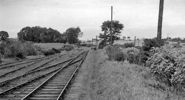
1124:== {{int:filedesc}} == {{Information |Description={{en|1=Site of Blackston Junction Station View westward, towards Coatbridge; ex-NBR Monklands line, Coatbridge - Causewayend - Manuel, junction for Bathgate. Both lines and Blackston Junction lost passenge
189:
125:
View westward, towards
Coatbridge; ex-NBR Monklands line, Coatbridge - Causewayend - Manuel, junction for Bathgate. Both lines and Blackston Junction lost passenger services on 1/5/30, but remained open for Goods until
331:– You must give appropriate credit, provide a link to the license, and indicate if changes were made. You may do so in any reasonable manner, but not in any way that suggests the licensor endorses you or your use.
203:
78:
46:
727:
872:
711:
561:
517:
719:
426:
1021:
976:
931:
864:
826:
723:
707:
643:
639:
513:
422:
414:
410:
735:
418:
868:
731:
715:
601:
557:
406:
1117:
564:"}},"text\/plain":{"en":{"P275":"Creative Commons Attribution-ShareAlike 2.0 Generic"}}}}": -->
167:
738:"}},"text\/plain":{"en":{"P973":"https:\/\/www.geograph.org.uk\/photo\/1821148"}}}}": -->
916:
761:
587:
543:
213:
781:
248:
1149:
This file contains additional information, probably added from the digital camera or scanner used to create or digitize it.
1193:
338:
498:
1106:
1101:
37:
1035:
990:
945:
882:
836:
789:
745:
684:
657:
527:
491:
476:
463:
1138:
909:
804:
774:
611:
571:
436:
395:
294:
1152:
If the file has been modified from its original state, some details may not fully reflect the modified file.
337:– If you remix, transform, or build upon the material, you must distribute your contributions under the
255:
on the
Geograph website for the photographer's contact details. The copyright on this image is owned by
938:"}},"text\/plain":{"en":{"P3575":"115,584 byte"}}}}": -->
429:"}},"text\/plain":{"en":{"P3831":"photographer"}}}}": -->
520:"}},"text\/plain":{"en":{"P6216":"copyrighted"}}}}": -->
650:"}},"text\/plain":{"en":{"P7787":"270 degree"}}}}": -->
1028:"}},"text\/plain":{"en":{"P2049":"640 pixel"}}}}": -->
983:"}},"text\/plain":{"en":{"P2048":"346 pixel"}}}}": -->
86:
875:"}},"text\/plain":{"en":{"P459":"SHA-1"}}}}": -->
811:
796:
483:
291:
8:
235:
219:
260:
73:
385:
156:
146:
1045:
1000:
955:
892:
846:
755:
667:
621:
581:
537:
446:
1208:
240:
252:
1074:
Click on a date/time to view the file as it appeared at that time.
205:
190:
55° 56′ 18.02″ N, 3° 43′ 47.04″ W
135:
61:
379:
Add a one-line explanation of what this file represents
111:
Blackston
Junction Station site of 1821148 994083ed.jpg
47:
Blackston_Junction_Station_site_of_1821148_994083ed.jpg
1132:
1072:
174:
Creative
Commons Attribution Share-alike license 2.0
85:
Commons is a freely licensed media file repository.
588:
Creative
Commons Attribution-ShareAlike 2.0 Generic
562:
Creative
Commons Attribution-ShareAlike 2.0 Generic
51:(640 × 346 pixels, file size: 113 KB, MIME type:
348:https://creativecommons.org/licenses/by-sa/2.0
66:
736:https:\/\/www.geograph.org.uk\/photo\/1821148
419:https:\/\/www.geograph.org.uk\/profile\/44502
354:Creative Commons Attribution-Share Alike 2.0
272:
162:
131:
108:
152:
141:
14:
1025:
980:
935:
647:
314:– to copy, distribute and transmit the work
812:https://www.geograph.org.uk/photo/1821148
484:https://www.geograph.org.uk/profile/44502
898:66f863b24d46723ee6bca3c703a3b972c2ae5968
212:View this and other nearby images on:
97:
1194:Adobe Photoshop Elements 3.0 Windows
259:and is licensed for reuse under the
180:
1134:The following page uses this file:
1065:
295:Attribution-Share Alike 2.0 Generic
283:
278:
263:Attribution-ShareAlike 2.0 license.
122:Site of Blackston Junction Station.
13:
1147:
1139:Blackston Junction railway station
384:
378:
269:
246:
115:
98:
44:
1225:
1154:
383:
658:coordinates of the point of view
640:coordinates of the point of view
369:
325:Under the following conditions:
290:This file is licensed under the
282:
277:
271:
239:
218:
204:
196:
65:
21:
366:
116:
41:No higher resolution available.
1069:
762:file available on the internet
712:file available on the internet
365:
247:This image was taken from the
26:
1:
673:55°56'18.024"N, 3°43'47.039"W
31:
1129:
782:Geograph Britain and Ireland
720:Geograph Britain and Ireland
492:object of statement has role
423:object of statement has role
391:Items portrayed in this file
231:
195:
7:
1144:
10:
1230:
339:same or compatible license
105:
100:
1200:File change date and time
1066:
16:
790:geograph.org.uk image ID
724:geograph.org.uk image ID
368:
305:
72:This is a file from the
36:
1123:
134:
76:. Information from its
1102:16:24, 24 January 2011
253:this photograph's page
224:55.938340; -3.729733
79:description page there
1174:Horizontal resolution
1203:22:48, 23 April 2010
910:determination method
869:determination method
1182:Vertical resolution
1161:EPSON scanner image
320:– to adapt the work
464:author name string
411:author name string
1217:
1216:
1127:
1027:
982:
937:
649:
627:19 September 1962
572:copyright license
558:copyright license
377:
268:
267:
251:collection. See
229:
228:
178:
177:
171:
168:Reusing this file
136:19 September 1962
94:
93:
74:Wikimedia Commons
1221:
1155:
1114:
1076:
1054:
1009:
964:
919:
914:
814:
809:
805:described at URL
799:
794:
784:
779:
732:described at URL
695:
694:
689:
528:copyright status
514:copyright status
501:
496:
486:
481:
471:
468:
375:
361:
358:
355:
352:
349:
341:as the original.
303:
292:Creative Commons
286:
285:
281:
280:
275:
274:
261:Creative Commons
249:Geograph project
243:
236:
225:
222:
208:
207:
201:
200:
199:
193:
192:
181:
165:
137:
120:
112:
106:
90:
69:
68:
62:
56:
54:
1229:
1228:
1224:
1223:
1222:
1220:
1219:
1218:
1143:
1128:
1120:
1112:
1068:
1067:
1064:
1063:
1062:
1061:
1060:
1059:
1058:
1057:
1055:
1052:
1042:
1041:
1040:
1038:
1019:
1018:
1017:
1016:
1015:
1014:
1013:
1012:
1010:
1007:
997:
996:
995:
993:
974:
973:
972:
971:
970:
969:
968:
967:
965:
962:
952:
951:
950:
948:
929:
928:
927:
926:
925:
924:
923:
922:
921:
920:
915:
912:
903:
902:
901:
899:
889:
888:
887:
885:
862:
861:
860:
859:
858:
857:
856:
855:
853:
843:
842:
841:
839:
824:
823:
822:
821:
820:
819:
818:
817:
816:
815:
810:
807:
801:
800:
795:
792:
786:
785:
780:
777:
768:
767:
766:
764:
752:
751:
750:
748:
705:
704:
703:
702:
701:
700:
699:
698:
697:
696:
692:
690:
687:
678:
677:
676:
674:
664:
663:
662:
660:
637:
636:
635:
634:
633:
632:
631:
630:
628:
618:
617:
616:
614:
599:
598:
597:
596:
595:
594:
593:
592:
590:
578:
577:
576:
574:
555:
554:
553:
552:
551:
550:
549:
548:
546:
534:
533:
532:
530:
511:
510:
509:
508:
507:
506:
505:
504:
503:
502:
497:
494:
488:
487:
482:
479:
473:
472:
469:
466:
457:
456:
455:
453:
443:
442:
441:
439:
404:
403:
402:
401:
400:
398:
382:
381:
380:
363:
362:
359:
356:
353:
350:
347:
346:
304:
301:
298:
287:
264:
234:
223:
197:
188:
187:
184:Camera location
179:
147:geograph.org.uk
127:
110:
103:
96:
95:
84:
83:
82:is shown below.
58:
52:
50:
43:
42:
12:
11:
5:
1227:
1215:
1214:
1211:
1205:
1204:
1201:
1197:
1196:
1191:
1187:
1186:
1183:
1179:
1178:
1175:
1171:
1170:
1167:
1163:
1162:
1159:
1146:
1142:
1141:
1131:
1126:
1125:
1122:
1118:
1115:
1109:
1104:
1099:
1095:
1094:
1091:
1088:
1085:
1082:
1079:
1071:
1056:
1050:
1048:
1047:
1046:
1044:
1043:
1039:
1034:
1032:
1031:
1030:
1029:
1023:
1011:
1005:
1003:
1002:
1001:
999:
998:
994:
989:
987:
986:
985:
984:
978:
966:
960:
958:
957:
956:
954:
953:
949:
944:
942:
941:
940:
939:
933:
908:
907:
906:
905:
904:
900:
897:
895:
894:
893:
891:
890:
886:
881:
879:
878:
877:
876:
874:
870:
866:
854:
851:
849:
848:
847:
845:
844:
840:
835:
833:
832:
831:
830:
828:
803:
802:
788:
787:
773:
772:
771:
770:
769:
765:
760:
758:
757:
756:
754:
753:
749:
746:source of file
744:
742:
741:
740:
739:
737:
733:
729:
725:
721:
717:
713:
709:
708:source of file
683:
682:
681:
680:
679:
675:
672:
670:
669:
668:
666:
665:
661:
656:
654:
653:
652:
651:
645:
641:
629:
626:
624:
623:
622:
620:
619:
615:
610:
608:
607:
606:
605:
603:
591:
586:
584:
583:
582:
580:
579:
575:
570:
568:
567:
566:
565:
563:
559:
547:
542:
540:
539:
538:
536:
535:
531:
526:
524:
523:
522:
521:
519:
515:
490:
489:
475:
474:
470:Ben Brooksbank
462:
461:
460:
459:
458:
454:
451:
449:
448:
447:
445:
444:
440:
435:
433:
432:
431:
430:
428:
424:
420:
416:
412:
408:
399:
394:
392:
389:
388:
387:
386:
374:
373:
370:
367:
345:
344:
343:
342:
332:
323:
322:
321:
315:
308:You are free:
302:Ben Brooksbank
299:
289:
288:
270:
266:
265:
257:Ben Brooksbank
244:
233:
230:
227:
226:
216:
210:
185:
176:
175:
172:
160:
159:
157:Ben Brooksbank
154:
150:
149:
143:
139:
138:
133:
129:
128:
113:
104:
102:
99:
92:
91:
70:
60:
59:
40:
35:
34:
29:
24:
19:
9:
6:
4:
3:
2:
1226:
1212:
1210:
1207:
1206:
1202:
1199:
1198:
1195:
1192:
1190:Software used
1189:
1188:
1184:
1181:
1180:
1176:
1173:
1172:
1168:
1165:
1164:
1160:
1157:
1156:
1153:
1150:
1140:
1137:
1136:
1135:
1121:
1116:
1110:
1108:
1105:
1103:
1100:
1097:
1096:
1092:
1089:
1086:
1083:
1080:
1078:
1077:
1075:
1049:
1037:
1033:
1004:
992:
988:
959:
947:
943:
918:
911:
896:
884:
880:
850:
838:
834:
813:
806:
798:
791:
783:
776:
763:
759:
747:
743:
686:
671:
659:
655:
625:
613:
609:
589:
585:
573:
569:
545:
541:
529:
525:
500:
493:
485:
478:
465:
450:
438:
434:
397:
393:
390:
371:
364:
351:CC BY-SA 2.0
340:
336:
333:
330:
327:
326:
324:
319:
316:
313:
310:
309:
307:
306:
300:Attribution:
296:
293:
276:
262:
258:
254:
250:
245:
242:
238:
237:
221:
217:
215:
214:OpenStreetMap
211:
209:
191:
186:
183:
182:
173:
169:
164:
161:
158:
155:
151:
148:
144:
140:
130:
124:
123:
119:
114:
107:
88:
81:
80:
75:
71:
64:
63:
57:
48:
39:
33:
30:
28:
25:
23:
20:
18:
15:
1213:Uncalibrated
1151:
1148:
1133:
1073:
1070:File history
499:photographer
427:photographer
334:
328:
317:
311:
256:
194:
121:
117:
87:You can help
77:
45:
22:File history
1209:Color space
1166:Orientation
1158:Image title
544:copyrighted
518:copyrighted
335:share alike
329:attribution
109:Description
1130:File usage
1111:640 × 346
1087:Dimensions
852:image/jpeg
837:media type
827:media type
452:some value
163:Permission
53:image/jpeg
27:File usage
1084:Thumbnail
1081:Date/Time
946:data size
932:data size
612:inception
602:inception
232:Licensing
118:English:
1145:Metadata
1113:(113 KB)
961:115,584
883:checksum
865:checksum
775:operator
716:operator
372:Captions
318:to remix
312:to share
297:license.
32:Metadata
1098:current
1093:Comment
797:1821148
728:1821148
685:heading
644:heading
437:creator
407:creator
396:depicts
376:English
101:Summary
49:
1185:78 dpc
1177:78 dpc
1169:Normal
1119:Belaro
991:height
977:height
693:degree
648:degree
202:
153:Author
142:Source
1053:pixel
1036:width
1026:pixel
1022:width
1008:pixel
981:pixel
917:SHA-1
873:SHA-1
145:From
126:1963.
1090:User
1051:640
1006:346
963:byte
936:byte
691:270
360:true
357:true
132:Date
17:File
477:URL
415:URL
913::
808::
793::
778::
688::
495::
480::
467::
170:)
166:(
89:.
55:)
