647:"}},"text\/plain":{"en":{"":"coordinates of the point of view"}}},"{\"value\":{\"latitude\":51.607064,\"longitude\":-0.123974,\"altitude\":null,\"precision\":1.0e-6,\"globe\":\"http:\\\/\\\/www.wikidata.org\\\/entity\\\/Q2\"},\"type\":\"globecoordinate\"}":{"text\/html":{"en":{"P1259":"51\u00b036'25.430"N, 0\u00b07'26.306"W"}},"text\/plain":{"en":{"P1259":"51\u00b036'25.430\"N, 0\u00b07'26.306\"W"}}},"{\"value\":{\"entity-type\":\"property\",\"numeric-id\":7787,\"id\":\"P7787\"},\"type\":\"wikibase-entityid\"}":{"text\/html":{"en":{"":"
872:"}},"text\/plain":{"en":{"":"checksum"}}},"{\"value\":\"3f964216b3ac74c2782727849d766b97529b035d\",\"type\":\"string\"}":{"text\/html":{"en":{"P4092":"3f964216b3ac74c2782727849d766b97529b035d"}},"text\/plain":{"en":{"P4092":"3f964216b3ac74c2782727849d766b97529b035d"}}},"{\"value\":{\"entity-type\":\"property\",\"numeric-id\":459,\"id\":\"P459\"},\"type\":\"wikibase-entityid\"}":{"text\/html":{"en":{"":"
418:"}},"text\/plain":{"en":{"":"author name string"}}},"{\"value\":\"Ben Brooksbank\",\"type\":\"string\"}":{"text\/html":{"en":{"P2093":"Ben Brooksbank"}},"text\/plain":{"en":{"P2093":"Ben Brooksbank"}}},"{\"value\":{\"entity-type\":\"property\",\"numeric-id\":2699,\"id\":\"P2699\"},\"type\":\"wikibase-entityid\"}":{"text\/html":{"en":{"":"
609:"}},"text\/plain":{"en":{"":"inception"}}},"{\"value\":{\"time\":\"+1955-07-13T00:00:00Z\",\"timezone\":0,\"before\":0,\"after\":0,\"precision\":11,\"calendarmodel\":\"http:\\\/\\\/www.wikidata.org\\\/entity\\\/Q1985727\"},\"type\":\"time\"}":{"text\/html":{"en":{"P571":"13 July 1955"}},"text\/plain":{"en":{"P571":"13 July 1955"}}}}": -->
711:
211:
868:
225:
246:
284:
289:
72:
426:"}},"text\/plain":{"en":{"P2699":"https:\/\/www.geograph.org.uk\/profile\/44502"}}},"{\"value\":{\"entity-type\":\"property\",\"numeric-id\":3831,\"id\":\"P3831\"},\"type\":\"wikibase-entityid\"}":{"text\/html":{"en":{"":"
719:"}},"text\/plain":{"en":{"P7482":"file available on the internet"}}},"{\"value\":{\"entity-type\":\"property\",\"numeric-id\":137,\"id\":\"P137\"},\"type\":\"wikibase-entityid\"}":{"text\/html":{"en":{"":"
727:"}},"text\/plain":{"en":{"P137":"Geograph Britain and Ireland"}}},"{\"value\":{\"entity-type\":\"property\",\"numeric-id\":7384,\"id\":\"P7384\"},\"type\":\"wikibase-entityid\"}":{"text\/html":{"en":{"":"
430:"}},"text\/plain":{"en":{"":"object of statement has role"}}},"{\"value\":{\"entity-type\":\"item\",\"numeric-id\":33231,\"id\":\"Q33231\"},\"type\":\"wikibase-entityid\"}":{"text\/html":{"en":{"P3831":"
876:"}},"text\/plain":{"en":{"":"determination method"}}},"{\"value\":{\"entity-type\":\"item\",\"numeric-id\":13414952,\"id\":\"Q13414952\"},\"type\":\"wikibase-entityid\"}":{"text\/html":{"en":{"P459":"
834:"}},"text\/plain":{"en":{"":"media type"}}},"{\"value\":\"image\\\/jpeg\",\"type\":\"string\"}":{"text\/html":{"en":{"P1163":"image\/jpeg"}},"text\/plain":{"en":{"P1163":"image\/jpeg"}}}}": -->
565:"}},"text\/plain":{"en":{"":"copyright license"}}},"{\"value\":{\"entity-type\":\"item\",\"numeric-id\":19068220,\"id\":\"Q19068220\"},\"type\":\"wikibase-entityid\"}":{"text\/html":{"en":{"P275":"
521:"}},"text\/plain":{"en":{"":"copyright status"}}},"{\"value\":{\"entity-type\":\"item\",\"numeric-id\":50423863,\"id\":\"Q50423863\"},\"type\":\"wikibase-entityid\"}":{"text\/html":{"en":{"P6216":"
1112:
715:"}},"text\/plain":{"en":{"":"source of file"}}},"{\"value\":{\"entity-type\":\"item\",\"numeric-id\":74228490,\"id\":\"Q74228490\"},\"type\":\"wikibase-entityid\"}":{"text\/html":{"en":{"P7482":"
939:"}},"text\/plain":{"en":{"":"data size"}}},"{\"value\":{\"amount\":\"+100217\",\"unit\":\"http:\\\/\\\/www.wikidata.org\\\/entity\\\/Q8799\"},\"type\":\"quantity\"}":{"text\/html":{"en":{"P3575":"100,217
984:"}},"text\/plain":{"en":{"":"height"}}},"{\"value\":{\"amount\":\"+375\",\"unit\":\"http:\\\/\\\/www.wikidata.org\\\/entity\\\/Q355198\"},\"type\":\"quantity\"}":{"text\/html":{"en":{"P2048":"375
723:"}},"text\/plain":{"en":{"":"operator"}}},"{\"value\":{\"entity-type\":\"item\",\"numeric-id\":1503119,\"id\":\"Q1503119\"},\"type\":\"wikibase-entityid\"}":{"text\/html":{"en":{"P137":"
651:"}},"text\/plain":{"en":{"":"heading"}}},"{\"value\":{\"amount\":\"+315\",\"unit\":\"http:\\\/\\\/www.wikidata.org\\\/entity\\\/Q28390\"},\"type\":\"quantity\"}":{"text\/html":{"en":{"P7787":"315
1029:"}},"text\/plain":{"en":{"":"width"}}},"{\"value\":{\"amount\":\"+640\",\"unit\":\"http:\\\/\\\/www.wikidata.org\\\/entity\\\/Q355198\"},\"type\":\"quantity\"}":{"text\/html":{"en":{"P2049":"640
735:"}},"text\/plain":{"en":{"P7384":"1860914"}}},"{\"value\":{\"entity-type\":\"property\",\"numeric-id\":973,\"id\":\"P973\"},\"type\":\"wikibase-entityid\"}":{"text\/html":{"en":{"":"
414:"}},"text\/plain":{"en":{"":"creator"}}},"{\"value\":{\"entity-type\":\"property\",\"numeric-id\":2093,\"id\":\"P2093\"},\"type\":\"wikibase-entityid\"}":{"text\/html":{"en":{"":"
1025:
731:"}},"text\/plain":{"en":{"":"geograph.org.uk image ID"}}},"{\"value\":\"1860914\",\"type\":\"string\"}":{"text\/html":{"en":{"P7384":"
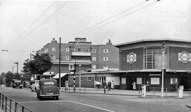
1129:== {{int:filedesc}} == {{Information |Description={{en|1=Bounds Green (Underground) Station, entrance View NW on Bounds Green Road; LT Piccadilly Line to Cockfosters. (This was the site of a dreadful incident in the Blitz of 1940, when a direct hit by a b
130:
View NW on Bounds Green Road; LT Piccadilly Line to
Cockfosters. (This was the site of a dreadful incident in the Blitz of 1940, when a direct hit by a bomb that penetrated to the tunnel (55 feet below the surface) killed 19
194:
336:– You must give appropriate credit, provide a link to the license, and indicate if changes were made. You may do so in any reasonable manner, but not in any way that suggests the licensor endorses you or your use.
208:
51:
83:
732:
877:
716:
566:
522:
724:
431:
1026:
981:
936:
869:
831:
728:
712:
648:
644:
518:
427:
419:
415:
740:
423:
873:
736:
720:
606:
562:
411:
569:"}},"text\/plain":{"en":{"P275":"Creative Commons Attribution-ShareAlike 2.0 Generic"}}}}": -->
172:
743:"}},"text\/plain":{"en":{"P973":"https:\/\/www.geograph.org.uk\/photo\/1860914"}}}}": -->
921:
766:
592:
548:
218:
786:
1111:
1106:
253:
42:
1184:
This file contains additional information, probably added from the digital camera or scanner used to create or digitize it.
1228:
343:
503:
1040:
995:
950:
887:
841:
794:
750:
689:
662:
532:
496:
481:
468:
914:
809:
779:
616:
576:
441:
400:
299:
1187:
If the file has been modified from its original state, some details may not fully reflect the modified file.
342:– If you remix, transform, or build upon the material, you must distribute your contributions under the
260:
on the
Geograph website for the photographer's contact details. The copyright on this image is owned by
943:"}},"text\/plain":{"en":{"P3575":"100,217 byte"}}}}": -->
434:"}},"text\/plain":{"en":{"P3831":"photographer"}}}}": -->
1143:
525:"}},"text\/plain":{"en":{"P6216":"copyrighted"}}}}": -->
655:"}},"text\/plain":{"en":{"P7787":"315 degree"}}}}": -->
1033:"}},"text\/plain":{"en":{"P2049":"640 pixel"}}}}": -->
988:"}},"text\/plain":{"en":{"P2048":"375 pixel"}}}}": -->
91:
880:"}},"text\/plain":{"en":{"P459":"SHA-1"}}}}": -->
816:
801:
488:
296:
8:
240:
224:
265:
78:
390:
161:
151:
1171:
1050:
1005:
960:
897:
851:
760:
672:
626:
586:
542:
451:
1243:
1122:
245:
1161:
257:
1079:
Click on a date/time to view the file as it appeared at that time.
210:
195:
51° 36′ 25.43″ N, 0° 07′ 26.31″ W
140:
66:
384:
Add a one-line explanation of what this file represents
116:
Bounds Green (Underground) Station 1860914 2020553d.jpg
52:
Bounds_Green_(Underground)_Station_1860914_2020553d.jpg
1137:
1152:
1077:
179:
Creative
Commons Attribution Share-alike license 2.0
90:
Commons is a freely licensed media file repository.
593:
Creative
Commons Attribution-ShareAlike 2.0 Generic
567:
Creative
Commons Attribution-ShareAlike 2.0 Generic
56:(640 × 375 pixels, file size: 98 KB, MIME type:
353:https://creativecommons.org/licenses/by-sa/2.0
71:
741:https:\/\/www.geograph.org.uk\/photo\/1860914
424:https:\/\/www.geograph.org.uk\/profile\/44502
359:Creative Commons Attribution-Share Alike 2.0
277:
167:
136:
127:Bounds Green (Underground) Station, entrance.
113:
157:
146:
14:
1030:
985:
940:
652:
319:– to copy, distribute and transmit the work
1154:The following other wikis use this file:
817:https://www.geograph.org.uk/photo/1860914
489:https://www.geograph.org.uk/profile/44502
903:3f964216b3ac74c2782727849d766b97529b035d
217:View this and other nearby images on:
102:
1229:Adobe Photoshop Elements 3.0 Windows
264:and is licensed for reuse under the
185:
1139:The following page uses this file:
1070:
300:Attribution-Share Alike 2.0 Generic
288:
283:
268:Attribution-ShareAlike 2.0 license.
13:
1182:
389:
383:
274:
251:
120:
103:
49:
1260:
1189:
388:
663:coordinates of the point of view
645:coordinates of the point of view
374:
330:Under the following conditions:
295:This file is licensed under the
287:
282:
276:
244:
223:
209:
201:
70:
31:
21:
371:
121:
46:No higher resolution available.
1168:Usage on simple.wikipedia.org
1149:
1074:
767:file available on the internet
717:file available on the internet
370:
252:This image was taken from the
26:
1:
36:
1134:
787:Geograph Britain and Ireland
725:Geograph Britain and Ireland
678:51°36'25.430"N, 0°7'26.306"W
497:object of statement has role
428:object of statement has role
396:Items portrayed in this file
236:
200:
7:
1179:
1162:Bounds Green (metrostation)
10:
1265:
1158:Usage on nl.wikipedia.org
344:same or compatible license
110:
105:
1235:File change date and time
1172:Bounds Green tube station
1144:Bounds Green tube station
1071:
16:
795:geograph.org.uk image ID
729:geograph.org.uk image ID
373:
310:
77:This is a file from the
41:
1128:
1107:14:31, 20 December 2010
139:
81:. Information from its
258:this photograph's page
229:51.607064; -0.123974
84:description page there
1209:Horizontal resolution
915:determination method
874:determination method
1217:Vertical resolution
1196:EPSON scanner image
325:– to adapt the work
1238:22:33, 15 May 2010
469:author name string
416:author name string
1252:
1251:
1150:Global file usage
1132:
1032:
987:
942:
654:
577:copyright license
563:copyright license
382:
273:
272:
256:collection. See
234:
233:
183:
182:
176:
173:Reusing this file
99:
98:
79:Wikimedia Commons
32:Global file usage
1256:
1190:
1119:
1081:
1059:
1014:
969:
924:
919:
819:
814:
810:described at URL
804:
799:
789:
784:
737:described at URL
700:
699:
694:
533:copyright status
519:copyright status
506:
501:
491:
486:
476:
473:
380:
366:
363:
360:
357:
354:
346:as the original.
308:
297:Creative Commons
291:
290:
286:
285:
280:
279:
266:Creative Commons
254:Geograph project
248:
241:
230:
227:
213:
212:
206:
205:
204:
198:
197:
186:
170:
142:
125:
117:
111:
95:
74:
73:
67:
61:
59:
1264:
1263:
1259:
1258:
1257:
1255:
1254:
1253:
1178:
1148:
1133:
1125:
1117:
1073:
1072:
1069:
1068:
1067:
1066:
1065:
1064:
1063:
1062:
1060:
1057:
1047:
1046:
1045:
1043:
1024:
1023:
1022:
1021:
1020:
1019:
1018:
1017:
1015:
1012:
1002:
1001:
1000:
998:
979:
978:
977:
976:
975:
974:
973:
972:
970:
967:
957:
956:
955:
953:
934:
933:
932:
931:
930:
929:
928:
927:
926:
925:
920:
917:
908:
907:
906:
904:
894:
893:
892:
890:
867:
866:
865:
864:
863:
862:
861:
860:
858:
848:
847:
846:
844:
829:
828:
827:
826:
825:
824:
823:
822:
821:
820:
815:
812:
806:
805:
800:
797:
791:
790:
785:
782:
773:
772:
771:
769:
757:
756:
755:
753:
710:
709:
708:
707:
706:
705:
704:
703:
702:
701:
697:
695:
692:
683:
682:
681:
679:
669:
668:
667:
665:
642:
641:
640:
639:
638:
637:
636:
635:
633:
623:
622:
621:
619:
604:
603:
602:
601:
600:
599:
598:
597:
595:
583:
582:
581:
579:
560:
559:
558:
557:
556:
555:
554:
553:
551:
539:
538:
537:
535:
516:
515:
514:
513:
512:
511:
510:
509:
508:
507:
502:
499:
493:
492:
487:
484:
478:
477:
474:
471:
462:
461:
460:
458:
448:
447:
446:
444:
409:
408:
407:
406:
405:
403:
387:
386:
385:
368:
367:
364:
361:
358:
355:
352:
351:
309:
306:
303:
292:
269:
239:
228:
202:
193:
192:
189:Camera location
184:
152:geograph.org.uk
132:
115:
108:
101:
100:
89:
88:
87:is shown below.
63:
57:
55:
48:
47:
12:
11:
5:
1262:
1250:
1249:
1246:
1240:
1239:
1236:
1232:
1231:
1226:
1222:
1221:
1218:
1214:
1213:
1210:
1206:
1205:
1202:
1198:
1197:
1194:
1181:
1177:
1176:
1175:
1174:
1166:
1165:
1164:
1151:
1147:
1146:
1136:
1131:
1130:
1127:
1123:
1120:
1114:
1109:
1104:
1100:
1099:
1096:
1093:
1090:
1087:
1084:
1076:
1061:
1055:
1053:
1052:
1051:
1049:
1048:
1044:
1039:
1037:
1036:
1035:
1034:
1028:
1016:
1010:
1008:
1007:
1006:
1004:
1003:
999:
994:
992:
991:
990:
989:
983:
971:
965:
963:
962:
961:
959:
958:
954:
949:
947:
946:
945:
944:
938:
913:
912:
911:
910:
909:
905:
902:
900:
899:
898:
896:
895:
891:
886:
884:
883:
882:
881:
879:
875:
871:
859:
856:
854:
853:
852:
850:
849:
845:
840:
838:
837:
836:
835:
833:
808:
807:
793:
792:
778:
777:
776:
775:
774:
770:
765:
763:
762:
761:
759:
758:
754:
751:source of file
749:
747:
746:
745:
744:
742:
738:
734:
730:
726:
722:
718:
714:
713:source of file
688:
687:
686:
685:
684:
680:
677:
675:
674:
673:
671:
670:
666:
661:
659:
658:
657:
656:
650:
646:
634:
631:
629:
628:
627:
625:
624:
620:
615:
613:
612:
611:
610:
608:
596:
591:
589:
588:
587:
585:
584:
580:
575:
573:
572:
571:
570:
568:
564:
552:
547:
545:
544:
543:
541:
540:
536:
531:
529:
528:
527:
526:
524:
520:
495:
494:
480:
479:
475:Ben Brooksbank
467:
466:
465:
464:
463:
459:
456:
454:
453:
452:
450:
449:
445:
440:
438:
437:
436:
435:
433:
429:
425:
421:
417:
413:
404:
399:
397:
394:
393:
392:
391:
379:
378:
375:
372:
350:
349:
348:
347:
337:
328:
327:
326:
320:
313:You are free:
307:Ben Brooksbank
304:
294:
293:
275:
271:
270:
262:Ben Brooksbank
249:
238:
235:
232:
231:
221:
215:
190:
181:
180:
177:
165:
164:
162:Ben Brooksbank
159:
155:
154:
148:
144:
143:
138:
134:
133:
118:
109:
107:
104:
97:
96:
75:
65:
64:
45:
40:
39:
34:
29:
24:
19:
9:
6:
4:
3:
2:
1261:
1247:
1245:
1242:
1241:
1237:
1234:
1233:
1230:
1227:
1225:Software used
1224:
1223:
1219:
1216:
1215:
1211:
1208:
1207:
1203:
1200:
1199:
1195:
1192:
1191:
1188:
1185:
1173:
1170:
1169:
1167:
1163:
1160:
1159:
1157:
1156:
1155:
1145:
1142:
1141:
1140:
1126:
1121:
1115:
1113:
1110:
1108:
1105:
1102:
1101:
1097:
1094:
1091:
1088:
1085:
1083:
1082:
1080:
1054:
1042:
1038:
1009:
997:
993:
964:
952:
948:
923:
916:
901:
889:
885:
855:
843:
839:
818:
811:
803:
796:
788:
781:
768:
764:
752:
748:
691:
676:
664:
660:
630:
618:
614:
594:
590:
578:
574:
550:
546:
534:
530:
505:
498:
490:
483:
470:
455:
443:
439:
402:
398:
395:
376:
369:
356:CC BY-SA 2.0
345:
341:
338:
335:
332:
331:
329:
324:
321:
318:
315:
314:
312:
311:
305:Attribution:
301:
298:
281:
267:
263:
259:
255:
250:
247:
243:
242:
226:
222:
220:
219:OpenStreetMap
216:
214:
196:
191:
188:
187:
178:
174:
169:
166:
163:
160:
156:
153:
149:
145:
135:
129:
128:
124:
119:
112:
93:
86:
85:
80:
76:
69:
68:
62:
53:
44:
38:
35:
33:
30:
28:
25:
23:
20:
18:
15:
1248:Uncalibrated
1186:
1183:
1153:
1138:
1078:
1075:File history
632:13 July 1955
504:photographer
432:photographer
339:
333:
322:
316:
261:
199:
141:13 July 1955
131:shelterers).
126:
122:
92:You can help
82:
50:
22:File history
1244:Color space
1201:Orientation
1193:Image title
549:copyrighted
523:copyrighted
340:share alike
334:attribution
114:Description
1135:File usage
1116:640 × 375
1092:Dimensions
857:image/jpeg
842:media type
832:media type
457:some value
168:Permission
58:image/jpeg
27:File usage
1089:Thumbnail
1086:Date/Time
951:data size
937:data size
617:inception
607:inception
237:Licensing
123:English:
1180:Metadata
966:100,217
888:checksum
870:checksum
780:operator
721:operator
377:Captions
323:to remix
317:to share
302:license.
37:Metadata
1118:(98 KB)
1103:current
1098:Comment
802:1860914
733:1860914
690:heading
649:heading
442:creator
412:creator
401:depicts
381:English
106:Summary
54:
1220:78 dpc
1212:78 dpc
1204:Normal
1124:Chevin
996:height
982:height
698:degree
653:degree
207:
158:Author
147:Source
1058:pixel
1041:width
1031:pixel
1027:width
1013:pixel
986:pixel
922:SHA-1
878:SHA-1
150:From
1095:User
1056:640
1011:375
968:byte
941:byte
696:315
365:true
362:true
137:Date
17:File
482:URL
420:URL
918::
813::
798::
783::
693::
500::
485::
472::
175:)
171:(
94:.
60:)
_Station_1860914_2020553d.jpg)
_Station_1860914_2020553d.jpg¶ms=051.607064_N_-000.123974_E_globe:Earth_type:camera_heading:315.00&language=en)
