819:"}},"text\/plain":{"en":{"":"coordinates of the point of view"}}},"{\"value\":{\"latitude\":51.614219,\"longitude\":-3.707232,\"altitude\":null,\"precision\":1.0e-6,\"globe\":\"http:\\\/\\\/www.wikidata.org\\\/entity\\\/Q2\"},\"type\":\"globecoordinate\"}":{"text\/html":{"en":{"P1259":"51\u00b036'51.188"N, 3\u00b042'26.035"W"}},"text\/plain":{"en":{"P1259":"51\u00b036'51.188\"N, 3\u00b042'26.035\"W"}}},"{\"value\":{\"entity-type\":\"property\",\"numeric-id\":7787,\"id\":\"P7787\"},\"type\":\"wikibase-entityid\"}":{"text\/html":{"en":{"":"
887:"}},"text\/plain":{"en":{"":"coordinates of depicted place"}}},"{\"value\":{\"latitude\":51.61427,\"longitude\":-3.7072,\"altitude\":null,\"precision\":1.0e-5,\"globe\":\"http:\\\/\\\/www.wikidata.org\\\/entity\\\/Q2\"},\"type\":\"globecoordinate\"}":{"text\/html":{"en":{"P9149":"51\u00b036'51.37"N, 3\u00b042'25.92"W"}},"text\/plain":{"en":{"P9149":"51\u00b036'51.37\"N, 3\u00b042'25.92\"W"}}},"{\"value\":{\"entity-type\":\"property\",\"numeric-id\":7787,\"id\":\"P7787\"},\"type\":\"wikibase-entityid\"}":{"text\/html":{"en":{"":"
993:"}},"text\/plain":{"en":{"":"checksum"}}},"{\"value\":\"017df00155ccc7251e9ad17dd16616bd15e704c1\",\"type\":\"string\"}":{"text\/html":{"en":{"P4092":"017df00155ccc7251e9ad17dd16616bd15e704c1"}},"text\/plain":{"en":{"P4092":"017df00155ccc7251e9ad17dd16616bd15e704c1"}}},"{\"value\":{\"entity-type\":\"property\",\"numeric-id\":459,\"id\":\"P459\"},\"type\":\"wikibase-entityid\"}":{"text\/html":{"en":{"":"
471:"}},"text\/plain":{"en":{"":"author name string"}}},"{\"value\":\"Ben Brooksbank\",\"type\":\"string\"}":{"text\/html":{"en":{"P2093":"Ben Brooksbank"}},"text\/plain":{"en":{"P2093":"Ben Brooksbank"}}},"{\"value\":{\"entity-type\":\"property\",\"numeric-id\":2699,\"id\":\"P2699\"},\"type\":\"wikibase-entityid\"}":{"text\/html":{"en":{"":"
662:"}},"text\/plain":{"en":{"":"inception"}}},"{\"value\":{\"time\":\"+1962-06-01T00:00:00Z\",\"timezone\":0,\"before\":0,\"after\":0,\"precision\":11,\"calendarmodel\":\"http:\\\/\\\/www.wikidata.org\\\/entity\\\/Q1985727\"},\"type\":\"time\"}":{"text\/html":{"en":{"P571":"1 June 1962"}},"text\/plain":{"en":{"P571":"1 June 1962"}}}}": -->
696:
264:
214:
256:
206:
989:
228:
299:
337:
342:
67:
1233:
479:"}},"text\/plain":{"en":{"P2699":"https:\/\/www.geograph.org.uk\/profile\/44502"}}},"{\"value\":{\"entity-type\":\"property\",\"numeric-id\":3831,\"id\":\"P3831\"},\"type\":\"wikibase-entityid\"}":{"text\/html":{"en":{"":"
704:"}},"text\/plain":{"en":{"P7482":"file available on the internet"}}},"{\"value\":{\"entity-type\":\"property\",\"numeric-id\":137,\"id\":\"P137\"},\"type\":\"wikibase-entityid\"}":{"text\/html":{"en":{"":"
712:"}},"text\/plain":{"en":{"P137":"Geograph Britain and Ireland"}}},"{\"value\":{\"entity-type\":\"property\",\"numeric-id\":7384,\"id\":\"P7384\"},\"type\":\"wikibase-entityid\"}":{"text\/html":{"en":{"":"
483:"}},"text\/plain":{"en":{"":"object of statement has role"}}},"{\"value\":{\"entity-type\":\"item\",\"numeric-id\":33231,\"id\":\"Q33231\"},\"type\":\"wikibase-entityid\"}":{"text\/html":{"en":{"P3831":"
997:"}},"text\/plain":{"en":{"":"determination method"}}},"{\"value\":{\"entity-type\":\"item\",\"numeric-id\":13414952,\"id\":\"Q13414952\"},\"type\":\"wikibase-entityid\"}":{"text\/html":{"en":{"P459":"
955:"}},"text\/plain":{"en":{"":"media type"}}},"{\"value\":\"image\\\/jpeg\",\"type\":\"string\"}":{"text\/html":{"en":{"P1163":"image\/jpeg"}},"text\/plain":{"en":{"P1163":"image\/jpeg"}}}}": -->
618:"}},"text\/plain":{"en":{"":"copyright license"}}},"{\"value\":{\"entity-type\":\"item\",\"numeric-id\":19068220,\"id\":\"Q19068220\"},\"type\":\"wikibase-entityid\"}":{"text\/html":{"en":{"P275":"
574:"}},"text\/plain":{"en":{"":"copyright status"}}},"{\"value\":{\"entity-type\":\"item\",\"numeric-id\":50423863,\"id\":\"Q50423863\"},\"type\":\"wikibase-entityid\"}":{"text\/html":{"en":{"P6216":"
700:"}},"text\/plain":{"en":{"":"source of file"}}},"{\"value\":{\"entity-type\":\"item\",\"numeric-id\":74228490,\"id\":\"Q74228490\"},\"type\":\"wikibase-entityid\"}":{"text\/html":{"en":{"P7482":"
1060:"}},"text\/plain":{"en":{"":"data size"}}},"{\"value\":{\"amount\":\"+97523\",\"unit\":\"http:\\\/\\\/www.wikidata.org\\\/entity\\\/Q8799\"},\"type\":\"quantity\"}":{"text\/html":{"en":{"P3575":"97,523
1105:"}},"text\/plain":{"en":{"":"height"}}},"{\"value\":{\"amount\":\"+327\",\"unit\":\"http:\\\/\\\/www.wikidata.org\\\/entity\\\/Q355198\"},\"type\":\"quantity\"}":{"text\/html":{"en":{"P2048":"327
891:"}},"text\/plain":{"en":{"":"heading"}}},"{\"value\":{\"amount\":\"+112\",\"unit\":\"http:\\\/\\\/www.wikidata.org\\\/entity\\\/Q28390\"},\"type\":\"quantity\"}":{"text\/html":{"en":{"P7787":"112
823:"}},"text\/plain":{"en":{"":"heading"}}},"{\"value\":{\"amount\":\"+112\",\"unit\":\"http:\\\/\\\/www.wikidata.org\\\/entity\\\/Q28390\"},\"type\":\"quantity\"}":{"text\/html":{"en":{"P7787":"112
708:"}},"text\/plain":{"en":{"":"operator"}}},"{\"value\":{\"entity-type\":\"item\",\"numeric-id\":1503119,\"id\":\"Q1503119\"},\"type\":\"wikibase-entityid\"}":{"text\/html":{"en":{"P137":"
1150:"}},"text\/plain":{"en":{"":"width"}}},"{\"value\":{\"amount\":\"+640\",\"unit\":\"http:\\\/\\\/www.wikidata.org\\\/entity\\\/Q355198\"},\"type\":\"quantity\"}":{"text\/html":{"en":{"P2049":"640
720:"}},"text\/plain":{"en":{"P7384":"1929028"}}},"{\"value\":{\"entity-type\":\"property\",\"numeric-id\":973,\"id\":\"P973\"},\"type\":\"wikibase-entityid\"}":{"text\/html":{"en":{"":"
467:"}},"text\/plain":{"en":{"":"creator"}}},"{\"value\":{\"entity-type\":\"property\",\"numeric-id\":2093,\"id\":\"P2093\"},\"type\":\"wikibase-entityid\"}":{"text\/html":{"en":{"":"
1146:
724:"}},"text\/plain":{"en":{"":"described at URL"}}},"{\"value\":\"https:\\\/\\\/www.geograph.org.uk\\\/photo\\\/1929028\",\"type\":\"string\"}":{"text\/html":{"en":{"P973":"
247:
475:"}},"text\/plain":{"en":{"":"URL"}}},"{\"value\":\"https:\\\/\\\/www.geograph.org.uk\\\/profile\\\/44502\",\"type\":\"string\"}":{"text\/html":{"en":{"P2699":"
716:"}},"text\/plain":{"en":{"":"geograph.org.uk image ID"}}},"{\"value\":\"1929028\",\"type\":\"string\"}":{"text\/html":{"en":{"P7384":"
197:
46:
389:– You must give appropriate credit, provide a link to the license, and indicate if changes were made. You may do so in any reasonable manner, but not in any way that suggests the licensor endorses you or your use.
78:
211:
261:
1243:
125:
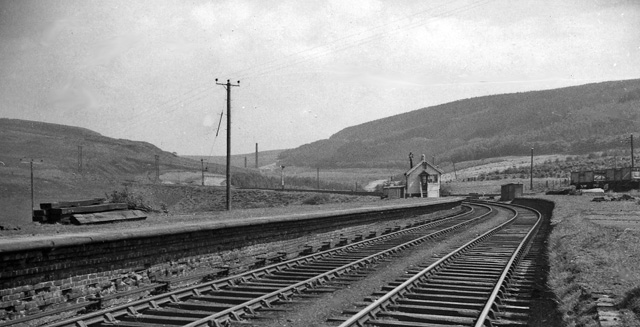
View SE, towards
Maesteg and Pont-y-rhyl; ex-Great Western (Port Talbot Railway), Port Talbot - Maesteg (Neath Road) - Pont-y-rhyl line, closed to passengers 11/9/33, to goods 31/8/64.
717:
998:
701:
619:
575:
709:
484:
1147:
1102:
1057:
990:
952:
888:
884:
820:
816:
713:
697:
571:
480:
472:
468:
725:
476:
994:
721:
705:
659:
615:
464:
149:
1232:
1227:
622:"}},"text\/plain":{"en":{"P275":"Creative Commons Attribution-ShareAlike 2.0 Generic"}}}}": -->
37:
175:
728:"}},"text\/plain":{"en":{"P973":"https:\/\/www.geograph.org.uk\/photo\/1929028"}}}}": -->
1042:
751:
645:
601:
271:
221:
771:
306:
1274:
This file contains additional information, probably added from the digital camera or scanner used to create or digitize it.
1318:
396:
556:
1161:
1116:
1071:
1008:
962:
929:
902:
861:
834:
779:
735:
585:
549:
534:
521:
1035:
794:
764:
669:
629:
494:
453:
1263:
352:
1277:
If the file has been modified from its original state, some details may not fully reflect the modified file.
395:– If you remix, transform, or build upon the material, you must distribute your contributions under the
313:
on the
Geograph website for the photographer's contact details. The copyright on this image is owned by
487:"}},"text\/plain":{"en":{"P3831":"photographer"}}}}": -->
1064:"}},"text\/plain":{"en":{"P3575":"97,523 byte"}}}}": -->
578:"}},"text\/plain":{"en":{"P6216":"copyrighted"}}}}": -->
895:"}},"text\/plain":{"en":{"P7787":"112 degree"}}}}": -->
827:"}},"text\/plain":{"en":{"P7787":"112 degree"}}}}": -->
1154:"}},"text\/plain":{"en":{"P2049":"640 pixel"}}}}": -->
1109:"}},"text\/plain":{"en":{"P2048":"327 pixel"}}}}": -->
86:
1001:"}},"text\/plain":{"en":{"P459":"SHA-1"}}}}": -->
801:
786:
541:
349:
8:
293:
277:
227:
318:
73:
443:
164:
145:
1171:
1126:
1081:
1018:
972:
912:
844:
745:
679:
639:
595:
504:
1333:
298:
310:
1200:
Click on a date/time to view the file as it appeared at that time.
111:
Bryn (Glamorgan) Station (remains) - geograph.org.uk - 1929028.jpg
47:
Bryn_(Glamorgan)_Station_(remains)_-_geograph.org.uk_-_1929028.jpg
263:
213:
198:
51° 36′ 51.19″ N, 3° 42′ 26.04″ W
153:
248:
51° 36′ 51″ N, 3° 42′ 26″ W
134:
61:
437:
Add a one-line explanation of what this file represents
1257:
1198:
182:
Creative
Commons Attribution Share-alike license 2.0
85:
Commons is a freely licensed media file repository.
646:
Creative
Commons Attribution-ShareAlike 2.0 Generic
620:
Creative
Commons Attribution-ShareAlike 2.0 Generic
51:(640 × 327 pixels, file size: 95 KB, MIME type:
406:https://creativecommons.org/licenses/by-sa/2.0
66:
726:https:\/\/www.geograph.org.uk\/photo\/1929028
477:https:\/\/www.geograph.org.uk\/profile\/44502
412:Creative Commons Attribution-Share Alike 2.0
330:
170:
130:
108:
160:
140:
14:
1151:
1106:
1061:
892:
824:
372:– to copy, distribute and transmit the work
802:https://www.geograph.org.uk/photo/1929028
542:https://www.geograph.org.uk/profile/44502
1024:017df00155ccc7251e9ad17dd16616bd15e704c1
270:View this and other nearby images on:
220:View this and other nearby images on:
97:
1319:Adobe Photoshop Elements 3.0 Windows
317:and is licensed for reuse under the
238:
188:
1259:The following page uses this file:
1191:
353:Attribution-Share Alike 2.0 Generic
341:
336:
321:Attribution-ShareAlike 2.0 license.
13:
1272:
442:
436:
327:
304:
122:Bryn (Glamorgan) Station (remains)
115:
98:
44:
1350:
1279:
441:
1264:Bryn railway station (Glamorgan)
835:coordinates of the point of view
817:coordinates of the point of view
427:
383:Under the following conditions:
348:This file is licensed under the
340:
335:
329:
297:
276:
262:
254:
226:
212:
204:
65:
21:
1245:File Upload Bot (Magnus Manske)
424:
116:
41:No higher resolution available.
1195:
752:file available on the internet
702:file available on the internet
423:
305:This image was taken from the
26:
1:
903:coordinates of depicted place
885:coordinates of depicted place
850:51°36'51.188"N, 3°42'26.035"W
31:
1254:
772:Geograph Britain and Ireland
710:Geograph Britain and Ireland
550:object of statement has role
481:object of statement has role
449:Items portrayed in this file
289:
253:
203:
7:
1269:
918:51°36'51.37"N, 3°42'25.92"W
10:
1355:
397:same or compatible license
105:
100:
1325:File change date and time
1192:
16:
780:geograph.org.uk image ID
714:geograph.org.uk image ID
426:
363:
72:This is a file from the
36:
1249:
133:
76:. Information from its
1228:15:21, 14 January 2011
311:this photograph's page
282:51.614270; -3.707200
232:51.614219; -3.707232
79:description page there
1299:Horizontal resolution
1036:determination method
995:determination method
154:geograph_org2commons
1328:23:27, 22 June 2010
1307:Vertical resolution
1286:EPSON scanner image
378:– to adapt the work
522:author name string
469:author name string
1342:
1341:
1252:
1153:
1108:
1063:
894:
826:
630:copyright license
616:copyright license
435:
326:
325:
309:collection. See
287:
286:
237:
236:
186:
185:
179:
176:Reusing this file
148:; transferred by
94:
93:
74:Wikimedia Commons
1346:
1280:
1240:
1202:
1180:
1135:
1090:
1045:
1040:
940:
939:
934:
872:
871:
866:
804:
799:
795:described at URL
789:
784:
774:
769:
722:described at URL
586:copyright status
572:copyright status
559:
554:
544:
539:
529:
526:
433:
419:
416:
413:
410:
407:
399:as the original.
361:
350:Creative Commons
344:
343:
339:
338:
333:
332:
319:Creative Commons
307:Geograph project
301:
294:
283:
280:
266:
265:
259:
258:
257:
251:
250:
239:
233:
230:
216:
215:
209:
208:
207:
201:
200:
189:
173:
136:
120:
112:
106:
90:
69:
68:
62:
56:
54:
1354:
1353:
1349:
1348:
1347:
1345:
1344:
1343:
1268:
1253:
1246:
1238:
1194:
1193:
1190:
1189:
1188:
1187:
1186:
1185:
1184:
1183:
1181:
1178:
1168:
1167:
1166:
1164:
1145:
1144:
1143:
1142:
1141:
1140:
1139:
1138:
1136:
1133:
1123:
1122:
1121:
1119:
1100:
1099:
1098:
1097:
1096:
1095:
1094:
1093:
1091:
1088:
1078:
1077:
1076:
1074:
1055:
1054:
1053:
1052:
1051:
1050:
1049:
1048:
1047:
1046:
1041:
1038:
1029:
1028:
1027:
1025:
1015:
1014:
1013:
1011:
988:
987:
986:
985:
984:
983:
982:
981:
979:
969:
968:
967:
965:
950:
949:
948:
947:
946:
945:
944:
943:
942:
941:
937:
935:
932:
923:
922:
921:
919:
909:
908:
907:
905:
882:
881:
880:
879:
878:
877:
876:
875:
874:
873:
869:
867:
864:
855:
854:
853:
851:
841:
840:
839:
837:
814:
813:
812:
811:
810:
809:
808:
807:
806:
805:
800:
797:
791:
790:
785:
782:
776:
775:
770:
767:
758:
757:
756:
754:
742:
741:
740:
738:
695:
694:
693:
692:
691:
690:
689:
688:
686:
676:
675:
674:
672:
657:
656:
655:
654:
653:
652:
651:
650:
648:
636:
635:
634:
632:
613:
612:
611:
610:
609:
608:
607:
606:
604:
592:
591:
590:
588:
569:
568:
567:
566:
565:
564:
563:
562:
561:
560:
555:
552:
546:
545:
540:
537:
531:
530:
527:
524:
515:
514:
513:
511:
501:
500:
499:
497:
462:
461:
460:
459:
458:
456:
440:
439:
438:
421:
420:
417:
414:
411:
408:
405:
404:
362:
359:
356:
345:
322:
292:
281:
255:
246:
245:
242:Object location
231:
205:
196:
195:
192:Camera location
187:
146:geograph.org.uk
126:
110:
103:
96:
95:
84:
83:
82:is shown below.
58:
52:
50:
43:
42:
12:
11:
5:
1352:
1340:
1339:
1336:
1330:
1329:
1326:
1322:
1321:
1316:
1312:
1311:
1308:
1304:
1303:
1300:
1296:
1295:
1292:
1288:
1287:
1284:
1271:
1267:
1266:
1256:
1251:
1250:
1248:
1244:
1241:
1235:
1230:
1225:
1221:
1220:
1217:
1214:
1211:
1208:
1205:
1197:
1182:
1176:
1174:
1173:
1172:
1170:
1169:
1165:
1160:
1158:
1157:
1156:
1155:
1149:
1137:
1131:
1129:
1128:
1127:
1125:
1124:
1120:
1115:
1113:
1112:
1111:
1110:
1104:
1092:
1086:
1084:
1083:
1082:
1080:
1079:
1075:
1070:
1068:
1067:
1066:
1065:
1059:
1034:
1033:
1032:
1031:
1030:
1026:
1023:
1021:
1020:
1019:
1017:
1016:
1012:
1007:
1005:
1004:
1003:
1002:
1000:
996:
992:
980:
977:
975:
974:
973:
971:
970:
966:
961:
959:
958:
957:
956:
954:
928:
927:
926:
925:
924:
920:
917:
915:
914:
913:
911:
910:
906:
901:
899:
898:
897:
896:
890:
886:
860:
859:
858:
857:
856:
852:
849:
847:
846:
845:
843:
842:
838:
833:
831:
830:
829:
828:
822:
818:
793:
792:
778:
777:
763:
762:
761:
760:
759:
755:
750:
748:
747:
746:
744:
743:
739:
736:source of file
734:
732:
731:
730:
729:
727:
723:
719:
715:
711:
707:
703:
699:
698:source of file
687:
684:
682:
681:
680:
678:
677:
673:
668:
666:
665:
664:
663:
661:
649:
644:
642:
641:
640:
638:
637:
633:
628:
626:
625:
624:
623:
621:
617:
605:
600:
598:
597:
596:
594:
593:
589:
584:
582:
581:
580:
579:
577:
573:
548:
547:
533:
532:
528:Ben Brooksbank
520:
519:
518:
517:
516:
512:
509:
507:
506:
505:
503:
502:
498:
493:
491:
490:
489:
488:
486:
482:
478:
474:
470:
466:
457:
452:
450:
447:
446:
445:
444:
432:
431:
428:
425:
403:
402:
401:
400:
390:
381:
380:
379:
373:
366:You are free:
360:Ben Brooksbank
357:
347:
346:
328:
324:
323:
315:Ben Brooksbank
302:
291:
288:
285:
284:
274:
268:
243:
235:
234:
224:
218:
193:
184:
183:
180:
168:
167:
165:Ben Brooksbank
162:
158:
157:
142:
138:
137:
132:
128:
127:
113:
104:
102:
99:
92:
91:
70:
60:
59:
40:
35:
34:
29:
24:
19:
9:
6:
4:
3:
2:
1351:
1337:
1335:
1332:
1331:
1327:
1324:
1323:
1320:
1317:
1315:Software used
1314:
1313:
1309:
1306:
1305:
1301:
1298:
1297:
1293:
1290:
1289:
1285:
1282:
1281:
1278:
1275:
1265:
1262:
1261:
1260:
1247:
1242:
1236:
1234:
1231:
1229:
1226:
1223:
1222:
1218:
1215:
1212:
1209:
1206:
1204:
1203:
1201:
1175:
1163:
1159:
1130:
1118:
1114:
1085:
1073:
1069:
1044:
1037:
1022:
1010:
1006:
976:
964:
960:
931:
916:
904:
900:
863:
848:
836:
832:
803:
796:
788:
781:
773:
766:
753:
749:
737:
733:
683:
671:
667:
647:
643:
631:
627:
603:
599:
587:
583:
558:
551:
543:
536:
523:
508:
496:
492:
455:
451:
448:
429:
422:
409:CC BY-SA 2.0
398:
394:
391:
388:
385:
384:
382:
377:
374:
371:
368:
367:
365:
364:
358:Attribution:
354:
351:
334:
320:
316:
312:
308:
303:
300:
296:
295:
279:
275:
273:
272:OpenStreetMap
269:
267:
249:
244:
241:
240:
229:
225:
223:
222:OpenStreetMap
219:
217:
199:
194:
191:
190:
181:
177:
172:
169:
166:
163:
159:
155:
151:
147:
143:
139:
129:
124:
123:
119:
114:
107:
88:
81:
80:
75:
71:
64:
63:
57:
48:
39:
33:
30:
28:
25:
23:
20:
18:
15:
1338:Uncalibrated
1276:
1273:
1258:
1199:
1196:File history
557:photographer
485:photographer
392:
386:
375:
369:
314:
252:
202:
121:
117:
87:You can help
77:
45:
22:File history
1334:Color space
1291:Orientation
1283:Image title
685:1 June 1962
602:copyrighted
576:copyrighted
393:share alike
387:attribution
150:User:belaro
135:1 June 1962
109:Description
1255:File usage
1237:640 × 327
1213:Dimensions
978:image/jpeg
963:media type
953:media type
510:some value
171:Permission
53:image/jpeg
27:File usage
1210:Thumbnail
1207:Date/Time
1072:data size
1058:data size
670:inception
660:inception
290:Licensing
118:English:
1270:Metadata
1009:checksum
991:checksum
765:operator
706:operator
430:Captions
376:to remix
370:to share
355:license.
32:Metadata
1239:(95 KB)
1224:current
1219:Comment
1087:97,523
930:heading
889:heading
862:heading
821:heading
787:1929028
718:1929028
495:creator
465:creator
454:depicts
434:English
101:Summary
49:
1310:78 dpc
1302:78 dpc
1294:Normal
1117:height
1103:height
938:degree
893:degree
870:degree
825:degree
260:
210:
161:Author
152:using
141:Source
1179:pixel
1162:width
1152:pixel
1148:width
1134:pixel
1107:pixel
1043:SHA-1
999:SHA-1
144:From
1216:User
1177:640
1132:327
1089:byte
1062:byte
936:112
868:112
418:true
415:true
131:Date
17:File
535:URL
473:URL
1039::
933::
865::
798::
783::
768::
553::
538::
525::
178:)
174:(
156:.
89:.
55:)
Text is available under the Creative Commons Attribution-ShareAlike License. Additional terms may apply.
_Station_(remains)_-_geograph.org.uk_-_1929028.jpg)
_Station_(remains)_-_geograph.org.uk_-_1929028.jpg¶ms=051.614219_N_-003.707232_E_globe:Earth_type:camera_heading:112.00_source:geograph&language=en)
_Station_(remains)_-_geograph.org.uk_-_1929028.jpg¶ms=051.614270_N_-003.707200_E_globe:Earth_class:object_type:object_source:geograph-osgb36(SS81899198)_region:GB-GBN_heading:112.00&language=en)
