925:"}},"text\/plain":{"en":{"":"checksum"}}},"{\"value\":\"fe6dfc842265d0c6dd2eabf4bf3e02a6a72a1f28\",\"type\":\"string\"}":{"text\/html":{"en":{"P4092":"fe6dfc842265d0c6dd2eabf4bf3e02a6a72a1f28"}},"text\/plain":{"en":{"P4092":"fe6dfc842265d0c6dd2eabf4bf3e02a6a72a1f28"}}},"{\"value\":{\"entity-type\":\"property\",\"numeric-id\":459,\"id\":\"P459\"},\"type\":\"wikibase-entityid\"}":{"text\/html":{"en":{"":"
849:"}},"text\/plain":{"en":{"":"coordinates of depicted place"}}},"{\"value\":{\"latitude\":50.706,\"longitude\":-3.99,\"altitude\":null,\"precision\":0.001,\"globe\":\"http:\\\/\\\/www.wikidata.org\\\/entity\\\/Q2\"},\"type\":\"globecoordinate\"}":{"text\/html":{"en":{"P9149":"50\u00b042'22"N, 3\u00b059'24"W"}},"text\/plain":{"en":{"P9149":"50\u00b042'22\"N, 3\u00b059'24\"W"}}}}": -->
465:"}},"text\/plain":{"en":{"":"author name string"}}},"{\"value\":\"Richard Knights\",\"type\":\"string\"}":{"text\/html":{"en":{"P2093":"Richard Knights"}},"text\/plain":{"en":{"P2093":"Richard Knights"}}},"{\"value\":{\"entity-type\":\"property\",\"numeric-id\":2699,\"id\":\"P2699\"},\"type\":\"wikibase-entityid\"}":{"text\/html":{"en":{"":"
767:"}},"text\/plain":{"en":{"":"inception"}}},"{\"value\":{\"time\":\"+2001-12-30T00:00:00Z\",\"timezone\":0,\"before\":0,\"after\":0,\"precision\":11,\"calendarmodel\":\"http:\\\/\\\/www.wikidata.org\\\/entity\\\/Q1985727\"},\"type\":\"time\"}":{"text\/html":{"en":{"P571":"30 December 2001"}},"text\/plain":{"en":{"P571":"30 December 2001"}}}}": -->
644:
449:
921:
258:
296:
301:
72:
652:"}},"text\/plain":{"en":{"P7482":"file available on the internet"}}},"{\"value\":{\"entity-type\":\"property\",\"numeric-id\":7384,\"id\":\"P7384\"},\"type\":\"wikibase-entityid\"}":{"text\/html":{"en":{"":"
457:"}},"text\/plain":{"en":{"":"object of statement has role"}}},"{\"value\":{\"entity-type\":\"item\",\"numeric-id\":33231,\"id\":\"Q33231\"},\"type\":\"wikibase-entityid\"}":{"text\/html":{"en":{"P3831":"
668:"}},"text\/plain":{"en":{"P137":"Geograph Britain and Ireland"}}},"{\"value\":{\"entity-type\":\"property\",\"numeric-id\":973,\"id\":\"P973\"},\"type\":\"wikibase-entityid\"}":{"text\/html":{"en":{"":"
929:"}},"text\/plain":{"en":{"":"determination method"}}},"{\"value\":{\"entity-type\":\"item\",\"numeric-id\":13414952,\"id\":\"Q13414952\"},\"type\":\"wikibase-entityid\"}":{"text\/html":{"en":{"P459":"
805:"}},"text\/plain":{"en":{"":"location of creation"}}},"{\"value\":{\"entity-type\":\"item\",\"numeric-id\":3922199,\"id\":\"Q3922199\"},\"type\":\"wikibase-entityid\"}":{"text\/html":{"en":{"P1071":"
887:"}},"text\/plain":{"en":{"":"media type"}}},"{\"value\":\"image\\\/jpeg\",\"type\":\"string\"}":{"text\/html":{"en":{"P1163":"image\/jpeg"}},"text\/plain":{"en":{"P1163":"image\/jpeg"}}}}": -->
604:"}},"text\/plain":{"en":{"":"copyright license"}}},"{\"value\":{\"entity-type\":\"item\",\"numeric-id\":19068220,\"id\":\"Q19068220\"},\"type\":\"wikibase-entityid\"}":{"text\/html":{"en":{"P275":"
560:"}},"text\/plain":{"en":{"":"copyright status"}}},"{\"value\":{\"entity-type\":\"item\",\"numeric-id\":50423863,\"id\":\"Q50423863\"},\"type\":\"wikibase-entityid\"}":{"text\/html":{"en":{"P6216":"
648:"}},"text\/plain":{"en":{"":"source of file"}}},"{\"value\":{\"entity-type\":\"item\",\"numeric-id\":74228490,\"id\":\"Q74228490\"},\"type\":\"wikibase-entityid\"}":{"text\/html":{"en":{"P7482":"
992:"}},"text\/plain":{"en":{"":"data size"}}},"{\"value\":{\"amount\":\"+101360\",\"unit\":\"http:\\\/\\\/www.wikidata.org\\\/entity\\\/Q8799\"},\"type\":\"quantity\"}":{"text\/html":{"en":{"P3575":"101,360
461:"}},"text\/plain":{"en":{"P3831":"photographer"}}},"{\"value\":{\"entity-type\":\"property\",\"numeric-id\":2093,\"id\":\"P2093\"},\"type\":\"wikibase-entityid\"}":{"text\/html":{"en":{"":"
1037:"}},"text\/plain":{"en":{"":"height"}}},"{\"value\":{\"amount\":\"+425\",\"unit\":\"http:\\\/\\\/www.wikidata.org\\\/entity\\\/Q355198\"},\"type\":\"quantity\"}":{"text\/html":{"en":{"P2048":"425
664:"}},"text\/plain":{"en":{"":"operator"}}},"{\"value\":{\"entity-type\":\"item\",\"numeric-id\":1503119,\"id\":\"Q1503119\"},\"type\":\"wikibase-entityid\"}":{"text\/html":{"en":{"P137":"
1082:"}},"text\/plain":{"en":{"":"width"}}},"{\"value\":{\"amount\":\"+640\",\"unit\":\"http:\\\/\\\/www.wikidata.org\\\/entity\\\/Q355198\"},\"type\":\"quantity\"}":{"text\/html":{"en":{"P2049":"640
406:"}},"text\/plain":{"en":{"":"depicts"}}},"{\"value\":{\"entity-type\":\"item\",\"numeric-id\":22667,\"id\":\"Q22667\"},\"type\":\"wikibase-entityid\"}":{"text\/html":{"en":{"P180":"
660:"}},"text\/plain":{"en":{"P7384":"16769"}}},"{\"value\":{\"entity-type\":\"property\",\"numeric-id\":137,\"id\":\"P137\"},\"type\":\"wikibase-entityid\"}":{"text\/html":{"en":{"":"
453:"}},"text\/plain":{"en":{"":"creator"}}},"{\"value\":{\"entity-type\":\"property\",\"numeric-id\":3831,\"id\":\"P3831\"},\"type\":\"wikibase-entityid\"}":{"text\/html":{"en":{"":"
1078:
672:"}},"text\/plain":{"en":{"":"described at URL"}}},"{\"value\":\"https:\\\/\\\/www.geograph.org.uk\\\/photo\\\/16769\",\"type\":\"string\"}":{"text\/html":{"en":{"P973":"
469:"}},"text\/plain":{"en":{"":"URL"}}},"{\"value\":\"https:\\\/\\\/www.geograph.org.uk\\\/profile\\\/657\",\"type\":\"string\"}":{"text\/html":{"en":{"P2699":"
43:
656:"}},"text\/plain":{"en":{"":"geograph.org.uk image ID"}}},"{\"value\":\"16769\",\"type\":\"string\"}":{"text\/html":{"en":{"P7384":"
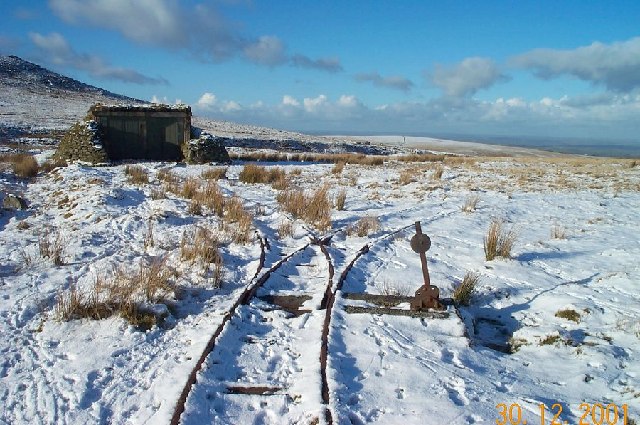
1182:== {{int:filedesc}} == {{Information |description={{en|1=Dartmoor Railway. The military railway points at SX 593911. This was a target railway where a small trolley carrying wooden targets was used to provide shooting practice for soldiers.}} |date=2001-1
214:
348:– You must give appropriate credit, provide a link to the license, and indicate if changes were made. You may do so in any reasonable manner, but not in any way that suggests the licensor endorses you or your use.
220:
126:
Dartmoor
Railway. The military railway points at SX 593911. This was a target railway where a small trolley carrying wooden targets was used to provide shooting practice for soldiers.
930:
649:
605:
561:
657:
806:
665:
458:
407:
83:
1079:
1034:
989:
922:
884:
846:
802:
653:
645:
557:
466:
462:
454:
51:
926:
764:
669:
661:
601:
450:
403:
673:
470:
1175:
608:"}},"text\/plain":{"en":{"P275":"Creative Commons Attribution-ShareAlike 2.0 Generic"}}}}": -->
473:"}},"text\/plain":{"en":{"P2699":"https:\/\/www.geograph.org.uk\/profile\/657"}}}}": -->
676:"}},"text\/plain":{"en":{"P973":"https:\/\/www.geograph.org.uk\/photo\/16769"}}}}": -->
974:
699:
631:
587:
230:
1196:
832:
734:
265:
1242:
This file contains additional information, probably added from the digital camera or scanner used to create or digitize it.
355:
514:
436:
1093:
1048:
1003:
940:
894:
856:
816:
712:
683:
571:
535:
522:
507:
967:
774:
742:
727:
615:
480:
420:
1164:
1159:
42:
311:
1245:
If the file has been modified from its original state, some details may not fully reflect the modified file.
809:"}},"text\/plain":{"en":{"P1071":"Okehampton Hamlets"}}}}": -->
354:– If you remix, transform, or build upon the material, you must distribute your contributions under the
272:
on the
Geograph website for the photographer's contact details. The copyright on this image is owned by
996:"}},"text\/plain":{"en":{"P3575":"101,360 byte"}}}}": -->
564:"}},"text\/plain":{"en":{"P6216":"copyrighted"}}}}": -->
1086:"}},"text\/plain":{"en":{"P2049":"640 pixel"}}}}": -->
1041:"}},"text\/plain":{"en":{"P2048":"425 pixel"}}}}": -->
91:
410:"}},"text\/plain":{"en":{"P180":"railway"}}}}": -->
183:
933:"}},"text\/plain":{"en":{"P459":"SHA-1"}}}}": -->
1201:
308:
167:
749:
719:
542:
8:
252:
236:
277:
78:
156:
146:
1103:
1058:
1013:
950:
904:
866:
826:
784:
693:
625:
581:
490:
430:
257:
269:
1132:
Click on a date/time to view the file as it appeared at that time.
1219:
222:
135:
66:
396:
Add a one-line explanation of what this file represents
1229:
1190:
1210:
1130:
90:
Commons is a freely licensed media file repository.
632:
Creative
Commons Attribution-ShareAlike 2.0 Generic
606:
Creative
Commons Attribution-ShareAlike 2.0 Generic
56:(640 × 425 pixels, file size: 99 KB, MIME type:
365:https://creativecommons.org/licenses/by-sa/2.0
116:Dartmoor Railway - geograph.org.uk - 16769.jpg
71:
52:Dartmoor_Railway_-_geograph.org.uk_-_16769.jpg
371:Creative Commons Attribution-Share Alike 2.0
289:
131:
113:
152:
141:
14:
1083:
1038:
993:
674:https:\/\/www.geograph.org.uk\/photo\/16769
471:https:\/\/www.geograph.org.uk\/profile\/657
331:– to copy, distribute and transmit the work
1212:The following other wikis use this file:
956:fe6dfc842265d0c6dd2eabf4bf3e02a6a72a1f28
750:https://www.geograph.org.uk/photo/16769
543:https://www.geograph.org.uk/profile/657
215:50° 42′ N, 3° 59′ W
1197:British military narrow-gauge railways
229:View this and other nearby images on:
1192:The following 2 pages use this file:
190:
102:
276:and is licensed for reuse under the
205:
1123:
312:Attribution-Share Alike 2.0 Generic
300:
295:
280:Attribution-ShareAlike 2.0 license.
13:
1240:
401:
395:
286:
263:
120:
103:
49:
1266:
1247:
400:
386:
342:Under the following conditions:
307:This file is licensed under the
299:
294:
288:
256:
235:
221:
70:
31:
21:
383:
121:
46:No higher resolution available.
1207:
1127:
700:file available on the internet
650:file available on the internet
382:
264:This image was taken from the
26:
1:
857:coordinates of depicted place
847:coordinates of depicted place
36:
1187:
735:Geograph Britain and Ireland
666:Geograph Britain and Ireland
508:object of statement has role
455:object of statement has role
416:Items portrayed in this file
248:
196:Richard Knights /
177:Richard Knights /
7:
1237:
10:
1271:
1226:Usage on www.wikidata.org
1216:Usage on de.wikipedia.org
356:same or compatible license
110:
105:
1124:
16:
713:geograph.org.uk image ID
654:geograph.org.uk image ID
385:
322:
77:This is a file from the
41:
1181:
168:required by the license
134:
81:. Information from its
1160:02:25, 30 January 2010
270:this photograph's page
241:50.706000; -3.990000
84:description page there
1220:Rowtor Target Railway
1202:Rowtor Target Railway
872:50°42'22"N, 3°59'24"W
968:determination method
927:determination method
817:location of creation
803:location of creation
337:– to adapt the work
833:Okehampton Hamlets
807:Okehampton Hamlets
523:author name string
463:author name string
1258:
1257:
1208:Global file usage
1185:
1085:
1040:
995:
616:copyright license
602:copyright license
394:
285:
284:
268:collection. See
246:
245:
203:
202:
171:
99:
98:
79:Wikimedia Commons
32:Global file usage
1262:
1248:
1172:
1134:
1112:
1067:
1022:
977:
972:
790:30 December 2001
752:
747:
743:described at URL
737:
732:
722:
717:
670:described at URL
572:copyright status
558:copyright status
545:
540:
530:
527:
517:
512:
392:
378:
375:
372:
369:
366:
358:as the original.
320:
309:Creative Commons
303:
302:
298:
297:
292:
291:
278:Creative Commons
266:Geograph project
260:
253:
242:
239:
225:
224:
218:
217:
206:
198:Dartmoor Railway
179:Dartmoor Railway
165:
137:
136:30 December 2001
125:
117:
111:
95:
74:
73:
67:
61:
59:
1270:
1269:
1265:
1264:
1263:
1261:
1260:
1259:
1236:
1206:
1186:
1178:
1170:
1126:
1125:
1122:
1121:
1120:
1119:
1118:
1117:
1116:
1115:
1113:
1110:
1100:
1099:
1098:
1096:
1077:
1076:
1075:
1074:
1073:
1072:
1071:
1070:
1068:
1065:
1055:
1054:
1053:
1051:
1032:
1031:
1030:
1029:
1028:
1027:
1026:
1025:
1023:
1020:
1010:
1009:
1008:
1006:
987:
986:
985:
984:
983:
982:
981:
980:
979:
978:
973:
970:
961:
960:
959:
957:
947:
946:
945:
943:
920:
919:
918:
917:
916:
915:
914:
913:
911:
901:
900:
899:
897:
882:
881:
880:
879:
878:
877:
876:
875:
873:
863:
862:
861:
859:
844:
843:
842:
841:
840:
839:
838:
837:
835:
823:
822:
821:
819:
800:
799:
798:
797:
796:
795:
794:
793:
791:
781:
780:
779:
777:
762:
761:
760:
759:
758:
757:
756:
755:
754:
753:
748:
745:
739:
738:
733:
730:
724:
723:
718:
715:
706:
705:
704:
702:
690:
689:
688:
686:
643:
642:
641:
640:
639:
638:
637:
636:
634:
622:
621:
620:
618:
599:
598:
597:
596:
595:
594:
593:
592:
590:
578:
577:
576:
574:
555:
554:
553:
552:
551:
550:
549:
548:
547:
546:
541:
538:
532:
531:
529:Richard Knights
528:
525:
519:
518:
513:
510:
501:
500:
499:
497:
487:
486:
485:
483:
448:
447:
446:
445:
444:
443:
442:
441:
439:
427:
426:
425:
423:
399:
398:
397:
380:
379:
376:
373:
370:
367:
364:
363:
321:
319:Richard Knights
318:
315:
304:
281:
274:Richard Knights
251:
240:
213:
212:
209:Object location
204:
193:
186:
174:
157:Richard Knights
147:geograph.org.uk
127:
115:
108:
101:
100:
89:
88:
87:is shown below.
63:
57:
55:
48:
47:
12:
11:
5:
1268:
1256:
1255:
1252:
1239:
1235:
1234:
1233:
1232:
1224:
1223:
1222:
1209:
1205:
1204:
1199:
1189:
1184:
1183:
1180:
1176:
1173:
1167:
1162:
1157:
1153:
1152:
1149:
1146:
1143:
1140:
1137:
1129:
1114:
1108:
1106:
1105:
1104:
1102:
1101:
1097:
1092:
1090:
1089:
1088:
1087:
1081:
1069:
1063:
1061:
1060:
1059:
1057:
1056:
1052:
1047:
1045:
1044:
1043:
1042:
1036:
1024:
1018:
1016:
1015:
1014:
1012:
1011:
1007:
1002:
1000:
999:
998:
997:
991:
966:
965:
964:
963:
962:
958:
955:
953:
952:
951:
949:
948:
944:
939:
937:
936:
935:
934:
932:
928:
924:
912:
909:
907:
906:
905:
903:
902:
898:
893:
891:
890:
889:
888:
886:
874:
871:
869:
868:
867:
865:
864:
860:
855:
853:
852:
851:
850:
848:
836:
831:
829:
828:
827:
825:
824:
820:
815:
813:
812:
811:
810:
808:
804:
792:
789:
787:
786:
785:
783:
782:
778:
773:
771:
770:
769:
768:
766:
741:
740:
726:
725:
711:
710:
709:
708:
707:
703:
698:
696:
695:
694:
692:
691:
687:
684:source of file
682:
680:
679:
678:
677:
675:
671:
667:
663:
659:
655:
651:
647:
646:source of file
635:
630:
628:
627:
626:
624:
623:
619:
614:
612:
611:
610:
609:
607:
603:
591:
586:
584:
583:
582:
580:
579:
575:
570:
568:
567:
566:
565:
563:
559:
534:
533:
521:
520:
506:
505:
504:
503:
502:
498:
495:
493:
492:
491:
489:
488:
484:
479:
477:
476:
475:
474:
472:
468:
464:
460:
456:
452:
440:
435:
433:
432:
431:
429:
428:
424:
419:
417:
414:
413:
412:
411:
409:
405:
391:
390:
387:
384:
362:
361:
360:
359:
349:
340:
339:
338:
332:
325:You are free:
316:
306:
305:
287:
283:
282:
261:
250:
247:
244:
243:
233:
227:
210:
201:
200:
194:
191:
188:
187:
182:
175:
172:
160:
159:
154:
150:
149:
143:
139:
138:
133:
129:
128:
118:
109:
107:
104:
97:
96:
75:
65:
64:
45:
40:
39:
34:
29:
24:
19:
9:
6:
4:
3:
2:
1267:
1253:
1250:
1249:
1246:
1243:
1231:
1228:
1227:
1225:
1221:
1218:
1217:
1215:
1214:
1213:
1203:
1200:
1198:
1195:
1194:
1193:
1179:
1174:
1168:
1166:
1163:
1161:
1158:
1155:
1154:
1150:
1147:
1144:
1141:
1138:
1136:
1135:
1133:
1107:
1095:
1091:
1062:
1050:
1046:
1017:
1005:
1001:
976:
969:
954:
942:
938:
908:
896:
892:
870:
858:
854:
834:
830:
818:
814:
788:
776:
772:
751:
744:
736:
729:
721:
714:
701:
697:
685:
681:
633:
629:
617:
613:
589:
585:
573:
569:
544:
537:
524:
516:
509:
494:
482:
478:
438:
434:
422:
418:
415:
388:
381:
368:CC BY-SA 2.0
357:
353:
350:
347:
344:
343:
341:
336:
333:
330:
327:
326:
324:
323:
317:Attribution:
313:
310:
293:
279:
275:
271:
267:
262:
259:
255:
254:
238:
234:
232:
231:OpenStreetMap
228:
226:
216:
211:
208:
207:
199:
195:
189:
185:
181: /
180:
176:
169:
164:
162:
161:
158:
155:
151:
148:
144:
140:
130:
124:
119:
112:
93:
86:
85:
80:
76:
69:
68:
62:
53:
44:
38:
35:
33:
30:
28:
25:
23:
20:
18:
15:
1244:
1241:
1211:
1191:
1131:
1128:File history
515:photographer
459:photographer
351:
345:
334:
328:
273:
197:
184:CC BY-SA 2.0
178:
122:
92:You can help
82:
50:
22:File history
1177:GeographBot
588:copyrighted
562:copyrighted
352:share alike
346:attribution
163:Attribution
114:Description
1251:_error
1188:File usage
1169:640 × 425
1145:Dimensions
910:image/jpeg
895:media type
885:media type
496:some value
58:image/jpeg
27:File usage
1230:Q29051382
1142:Thumbnail
1139:Date/Time
1004:data size
990:data size
775:inception
765:inception
249:Licensing
192:InfoField
173:InfoField
123:English:
1238:Metadata
1019:101,360
941:checksum
923:checksum
728:operator
662:operator
389:Captions
335:to remix
329:to share
314:license.
37:Metadata
1171:(99 KB)
1156:current
1151:Comment
481:creator
451:creator
437:railway
421:depicts
408:railway
404:depicts
393:English
106:Summary
54:
1049:height
1035:height
219:
153:Author
142:Source
1111:pixel
1094:width
1084:pixel
1080:width
1066:pixel
1039:pixel
975:SHA-1
931:SHA-1
720:16769
658:16769
145:From
1148:User
1109:640
1064:425
1021:byte
994:byte
377:true
374:true
132:Date
17:File
536:URL
467:URL
971::
746::
731::
716::
539::
526::
511::
1254:0
170:)
166:(
94:.
60:)
_&language=en)
