498:"}},"text\/plain":{"en":{"":"inception"}}},"{\"value\":{\"time\":\"+2010-09-26T00:00:00Z\",\"timezone\":0,\"before\":0,\"after\":0,\"precision\":11,\"calendarmodel\":\"http:\\\/\\\/www.wikidata.org\\\/entity\\\/Q1985727\"},\"type\":\"time\"}":{"text\/html":{"en":{"P571":"26 September 2010"}},"text\/plain":{"en":{"P571":"26 September 2010"}}}}": -->
43:
258:
264:
269:
99:
454:"}},"text\/plain":{"en":{"":"copyright license"}}},"{\"value\":{\"entity-type\":\"item\",\"numeric-id\":14946043,\"id\":\"Q14946043\"},\"type\":\"wikibase-entityid\"}":{"text\/html":{"en":{"P275":"
410:"}},"text\/plain":{"en":{"":"copyright status"}}},"{\"value\":{\"entity-type\":\"item\",\"numeric-id\":50423863,\"id\":\"Q50423863\"},\"type\":\"wikibase-entityid\"}":{"text\/html":{"en":{"P6216":"
406:
316:– You must give appropriate credit, provide a link to the license, and indicate if changes were made. You may do so in any reasonable manner, but not in any way that suggests the licensor endorses you or your use.
595:, UK with the following information shown: *Administrative borders *Coastline, lakes and rivers *Roads and railways *Urban areas Equirectangular map projection on WGS 84 datum, with N/S s
1108:
455:
411:
858:
407:
1115:
606:
495:
451:
1432:
73:
69:
65:
61:
57:
53:
47:
458:"}},"text\/plain":{"en":{"P275":"Creative Commons Attribution-ShareAlike 3.0 Unported"}}}}": -->
110:
247:
82:
868:
1423:
481:
437:
1418:
218:
1443:
This file contains additional information, probably added from the digital camera or scanner used to create or digitize it.
323:
1183:
421:
505:
465:
396:
958:
903:
863:
279:
1446:
If the file has been modified from its original state, some details may not fully reflect the modified file.
605:
More than 100 pages use this file. The following list shows the first 100 pages that use this file only. A
833:
793:
356:
322:– If you remix, transform, or build upon the material, you must distribute your contributions under the
738:
414:"}},"text\/plain":{"en":{"P6216":"copyrighted"}}}}": -->
1343:
1133:
1083:
943:
853:
204:
1023:
918:
773:
118:
573:
568:
42:
883:
778:
633:
1188:
658:
653:
1098:
828:
276:
8:
1063:
1058:
968:
668:
648:
1388:
1353:
838:
698:
628:
222:
1143:
758:
723:
105:
718:
386:
1413:
913:
893:
843:
823:
818:
201:
1368:
1363:
1358:
688:
235:
1153:
973:
763:
584:
998:
1348:
1013:
988:
953:
798:
788:
753:
515:
475:
431:
1048:
1018:
908:
733:
703:
144:
164:
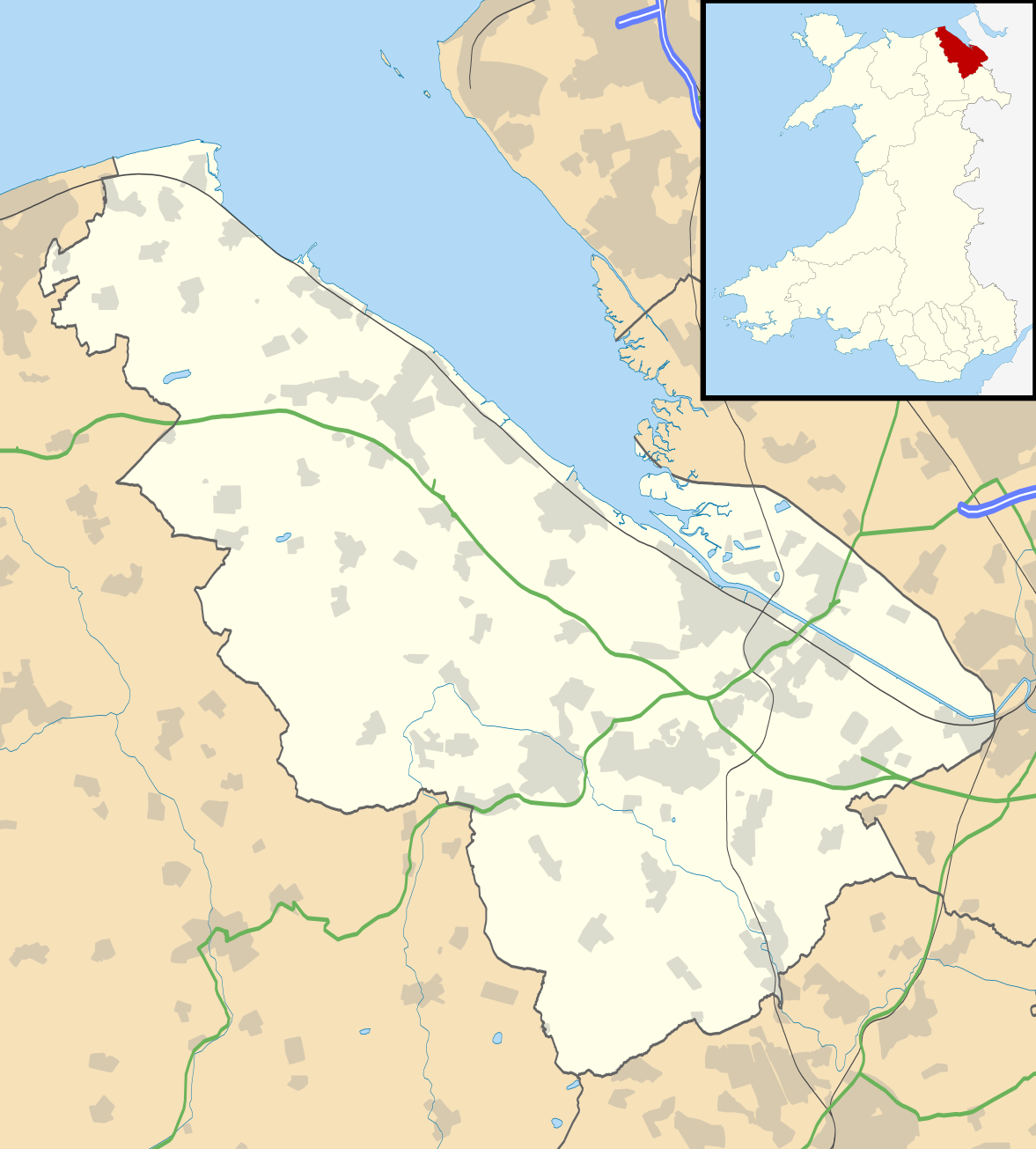
Equirectangular map projection on WGS 84 datum, with N/S stretched 165%
1053:
1028:
1008:
1003:
928:
768:
713:
613:
592:
1393:
1208:
1103:
1078:
1043:
1038:
1033:
983:
978:
963:
678:
211:
Administrative borders and coastline data from
Boundary-Line product.
1278:
1283:
1184:
Wikiproyecto:Ilustración/Taller de
Cartografía/Realizaciones/Europa
1093:
1088:
933:
848:
813:
663:
541:
Click on a date/time to view the file as it appeared at that time.
1378:
1248:
287:
Contains
Ordnance Survey data © Crown copyright and database right
1298:
1073:
1068:
993:
948:
938:
878:
803:
783:
708:
693:
683:
643:
623:
618:
1233:
1288:
923:
898:
808:
748:
673:
638:
1253:
1203:
1109:
User:Onshore/sandbox/2019–20 North East Wales
Football League
873:
743:
728:
87:(SVG file, nominally 1,177 × 1,305 pixels, file size: 758 KB)
888:
1268:
859:
List of Sites of
Special Scientific Interest in Flintshire
1403:
1383:
1313:
1258:
1218:
190:
93:
1273:
1163:
380:
Add a one-line explanation of what this file represents
1308:
1263:
1333:
1323:
1318:
1238:
603:
1328:
1293:
1243:
1213:
1198:
1124:
539:
482:
Creative
Commons Attribution-ShareAlike 3.0 Unported
456:
Creative
Commons Attribution-ShareAlike 3.0 Unported
117:
Commons is a freely licensed media file repository.
1303:
1223:
1193:
1173:
1228:
214:All other geographic data from Meridian 2 product.
333:https://creativecommons.org/licenses/by-sa/3.0
98:
339:Creative Commons Attribution-Share Alike 3.0
257:
242:
186:
135:
1424:モジュール:Location map/data/Wales Flintshire/doc
1189:Plantilla:Mapa de localización de Flintshire
352:
231:
196:
14:
299:– to copy, distribute and transmit the work
147:, UK with the following information shown:
46:Size of this PNG preview of this SVG file:
1126:The following other wikis use this file:
869:List of scheduled monuments in Flintshire
1419:モジュール:Location map/data/Wales Flintshire
591:{{Information |Description=Blank map of
1144:Plantilya:Location map Wales Flintshire
1414:Template:Location map Wales Flintshire
219:File: United Kingdom location map.svg
129:
280:Attribution-Share Alike 3.0 Unported
238:, created using Ordnance Survey data
1154:Nodyn:Location map Wales Flintshire
532:
268:
263:
13:
1441:
1344:الگو:Location map Wales Flintshire
1134:قالب:Location map Wales Flintshire
385:
379:
254:
130:
80:
1475:
1448:
1389:Modèle:Géolocalisation/Flintshire
384:
959:Northop Hall Country House Hotel
904:Moel-y-Parc transmitting station
864:List of monastic houses in Wales
370:
310:Under the following conditions:
275:This file is licensed under the
267:
262:
256:
97:
31:
21:
367:
1121:
536:
366:
138:Flintshire UK location map.svg
26:
1:
36:
600:
392:Items portrayed in this file
7:
1438:
1140:Usage on ceb.wikipedia.org
834:Holywell Community Hospital
794:Gwernaffield with Pantymwyn
154:Coastline, lakes and rivers
10:
1480:
1410:Usage on ja.wikipedia.org
1400:Usage on gv.wikipedia.org
1375:Usage on fr.wikipedia.org
1340:Usage on fa.wikipedia.org
1180:Usage on es.wikipedia.org
1170:Usage on eo.wikipedia.org
1160:Usage on da.wikipedia.org
1150:Usage on cy.wikipedia.org
1130:Usage on ar.wikipedia.org
739:Deeside Community Hospital
357:File:Flintshire UK map.svg
324:same or compatible license
132:
1209:New Brighton (Flintshire)
533:
16:
1084:Trelawnyd and Gwaenysgor
944:New Brighton, Flintshire
854:Leeswood and Pontblyddyn
569:19:33, 26 September 2010
369:
290:
104:This is a file from the
41:
1279:Deeside Industrial Park
1024:Queensferry, Flintshire
919:Mold Community Hospital
774:Garden City, Flintshire
590:
189:
108:. Information from its
1284:Broughton (Flintshire)
884:Llanfynydd, Flintshire
779:Greenfield, Flintshire
634:Aston Park, Flintshire
151:Administrative borders
111:description page there
1249:Holywell (Flintshire)
659:Broughton and Bretton
654:Broughton, Flintshire
1394:Aéroport de Hawarden
1299:Buckley (Flintshire)
1099:Whitford, Flintshire
829:Holywell, Flintshire
74:1,177 × 1,305 pixels
70:1,847 × 2,048 pixels
1234:Gwernaffield-y-Waun
1064:Shotton, Flintshire
1059:Sealand, Flintshire
969:Ogof Hen Ffynhonnau
669:Buckley, Flintshire
649:Bretton, Flintshire
305:– to adapt the work
217:Inset derived from
167:Geographic limits:
52:Other resolutions:
1289:Flint (Flintshire)
839:Holywell Golf Club
719:Connah's Quay
699:Carmel, Flintshire
629:Argoed, Flintshire
157:Roads and railways
66:924 × 1,024 pixels
1467:
1466:
1433:more global usage
1254:Hope (Flintshire)
1122:Global file usage
759:Flint, Flintshire
724:County Hall, Mold
598:
521:26 September 2010
466:copyright license
452:copyright license
378:
363:
362:
251:
248:Reusing this file
191:26 September 2010
126:
125:
106:Wikimedia Commons
32:Global file usage
1471:
1449:
1379:Château de Flint
1204:Higher Kinnerton
914:Mold, Flintshire
894:Lluesty Hospital
844:Hope, Flintshire
824:Higher Kinnerton
819:Hawarden Airport
581:
543:
422:copyright status
408:copyright status
376:
346:
343:
340:
337:
334:
326:as the original.
288:
277:Creative Commons
271:
270:
266:
265:
260:
259:
245:
192:
139:
133:
122:
101:
100:
94:
88:
77:
62:693 × 768 pixels
58:433 × 480 pixels
54:216 × 240 pixels
48:541 × 600 pixels
1479:
1478:
1474:
1473:
1472:
1470:
1469:
1468:
1437:
1120:
689:Caerwys Rectory
599:
587:
579:
535:
534:
531:
530:
529:
528:
527:
526:
525:
524:
522:
512:
511:
510:
508:
493:
492:
491:
490:
489:
488:
487:
486:
484:
472:
471:
470:
468:
449:
448:
447:
446:
445:
444:
443:
442:
440:
428:
427:
426:
424:
405:
404:
403:
402:
401:
399:
383:
382:
381:
364:
348:
347:
344:
341:
338:
335:
332:
331:
289:
286:
283:
272:
202:Ordnance Survey
137:
128:
127:
116:
115:
114:is shown below.
90:
86:
79:
78:
51:
12:
11:
5:
1477:
1465:
1464:
1461:
1457:
1456:
1453:
1440:
1435:of this file.
1429:
1428:
1427:
1426:
1421:
1416:
1408:
1407:
1406:
1398:
1397:
1396:
1391:
1386:
1381:
1373:
1372:
1371:
1366:
1361:
1356:
1351:
1346:
1338:
1337:
1336:
1331:
1326:
1321:
1316:
1311:
1306:
1301:
1296:
1291:
1286:
1281:
1276:
1271:
1266:
1261:
1256:
1251:
1246:
1241:
1236:
1231:
1226:
1221:
1216:
1211:
1206:
1201:
1196:
1191:
1186:
1178:
1177:
1176:
1168:
1167:
1166:
1158:
1157:
1156:
1148:
1147:
1146:
1138:
1137:
1136:
1123:
1118:to this file.
1112:
1111:
1106:
1101:
1096:
1091:
1086:
1081:
1076:
1071:
1066:
1061:
1056:
1051:
1046:
1041:
1036:
1031:
1026:
1021:
1016:
1011:
1006:
1001:
996:
991:
986:
981:
976:
974:Ogof Hesp Alyn
971:
966:
961:
956:
951:
946:
941:
936:
931:
926:
921:
916:
911:
906:
901:
896:
891:
886:
881:
876:
871:
866:
861:
856:
851:
846:
841:
836:
831:
826:
821:
816:
811:
806:
801:
796:
791:
786:
781:
776:
771:
766:
764:Flint Mountain
761:
756:
751:
746:
741:
736:
731:
726:
721:
716:
711:
706:
701:
696:
691:
686:
681:
676:
671:
666:
661:
656:
651:
646:
641:
636:
631:
626:
621:
616:
609:is available.
602:
597:
596:
589:
585:
582:
578:1,177 × 1,305
576:
571:
566:
562:
561:
558:
555:
552:
549:
546:
538:
523:
520:
518:
517:
516:
514:
513:
509:
504:
502:
501:
500:
499:
497:
485:
480:
478:
477:
476:
474:
473:
469:
464:
462:
461:
460:
459:
457:
453:
441:
436:
434:
433:
432:
430:
429:
425:
420:
418:
417:
416:
415:
413:
409:
400:
395:
393:
390:
389:
388:
387:
375:
374:
371:
368:
361:
360:
354:
353:Other versions
350:
349:
330:
329:
328:
327:
317:
308:
307:
306:
300:
293:You are free:
284:
274:
273:
255:
252:
240:
239:
233:
229:
228:
227:
226:
215:
212:
198:
194:
193:
188:
184:
183:
182:
181:
178:
175:
172:
162:
161:
158:
155:
152:
140:
131:
124:
123:
102:
92:
91:
45:
40:
39:
34:
29:
24:
19:
9:
6:
4:
3:
2:
1476:
1462:
1459:
1458:
1454:
1451:
1450:
1447:
1444:
1436:
1434:
1425:
1422:
1420:
1417:
1415:
1412:
1411:
1409:
1405:
1402:
1401:
1399:
1395:
1392:
1390:
1387:
1385:
1382:
1380:
1377:
1376:
1374:
1370:
1367:
1365:
1362:
1360:
1357:
1355:
1352:
1350:
1347:
1345:
1342:
1341:
1339:
1335:
1332:
1330:
1327:
1325:
1322:
1320:
1317:
1315:
1312:
1310:
1307:
1305:
1302:
1300:
1297:
1295:
1292:
1290:
1287:
1285:
1282:
1280:
1277:
1275:
1272:
1270:
1269:Pentre Halkyn
1267:
1265:
1262:
1260:
1257:
1255:
1252:
1250:
1247:
1245:
1242:
1240:
1237:
1235:
1232:
1230:
1227:
1225:
1222:
1220:
1217:
1215:
1212:
1210:
1207:
1205:
1202:
1200:
1197:
1195:
1192:
1190:
1187:
1185:
1182:
1181:
1179:
1175:
1172:
1171:
1169:
1165:
1162:
1161:
1159:
1155:
1152:
1151:
1149:
1145:
1142:
1141:
1139:
1135:
1132:
1131:
1129:
1128:
1127:
1119:
1117:
1110:
1107:
1105:
1102:
1100:
1097:
1095:
1092:
1090:
1087:
1085:
1082:
1080:
1077:
1075:
1072:
1070:
1067:
1065:
1062:
1060:
1057:
1055:
1052:
1050:
1047:
1045:
1042:
1040:
1037:
1035:
1032:
1030:
1027:
1025:
1022:
1020:
1017:
1015:
1012:
1010:
1007:
1005:
1002:
1000:
999:Pentre Halkyn
997:
995:
992:
990:
987:
985:
982:
980:
977:
975:
972:
970:
967:
965:
962:
960:
957:
955:
952:
950:
947:
945:
942:
940:
937:
935:
932:
930:
927:
925:
922:
920:
917:
915:
912:
910:
907:
905:
902:
900:
897:
895:
892:
890:
887:
885:
882:
880:
877:
875:
872:
870:
867:
865:
862:
860:
857:
855:
852:
850:
847:
845:
842:
840:
837:
835:
832:
830:
827:
825:
822:
820:
817:
815:
812:
810:
807:
805:
802:
800:
797:
795:
792:
790:
787:
785:
782:
780:
777:
775:
772:
770:
767:
765:
762:
760:
757:
755:
752:
750:
747:
745:
742:
740:
737:
735:
732:
730:
727:
725:
722:
720:
717:
715:
712:
710:
707:
705:
702:
700:
697:
695:
692:
690:
687:
685:
682:
680:
677:
675:
672:
670:
667:
665:
662:
660:
657:
655:
652:
650:
647:
645:
642:
640:
637:
635:
632:
630:
627:
625:
622:
620:
617:
615:
612:
611:
610:
608:
594:
588:
583:
577:
575:
572:
570:
567:
564:
563:
559:
556:
553:
550:
547:
545:
544:
542:
519:
507:
503:
483:
479:
467:
463:
439:
435:
423:
419:
398:
394:
391:
372:
365:
358:
355:
351:
336:CC BY-SA 3.0
325:
321:
318:
315:
312:
311:
309:
304:
301:
298:
295:
294:
292:
291:
285:Attribution:
281:
278:
261:
253:
249:
244:
241:
237:
234:
230:
224:
220:
216:
213:
210:
209:
208:
206:
203:
199:
195:
185:
180:South: 53.05N
179:
177:North: 53.40N
176:
173:
170:
169:
168:
165:
159:
156:
153:
150:
149:
148:
146:
143:Blank map of
141:
134:
120:
113:
112:
107:
103:
96:
95:
89:
84:
83:Original file
75:
71:
67:
63:
59:
55:
49:
44:
38:
35:
33:
30:
28:
25:
23:
20:
18:
15:
1445:
1442:
1430:
1404:Sir y Fflint
1384:The Airfield
1314:Northop Hall
1259:Pen-y-ffordd
1219:Gwernymynydd
1125:
1113:
1014:Point of Ayr
989:Pen-y-ffordd
954:Northop Hall
799:Gwernymynydd
789:Gwernaffield
754:Ffynnongroew
604:
540:
537:File history
319:
313:
302:
296:
223:NordNordWest
200:
166:
163:
142:
119:You can help
109:
81:
22:File history
1049:Rhydyn Hall
1019:Pontblyddyn
909:Moel Arthur
734:Dee Estuary
704:Cefn-y-bedd
438:copyrighted
412:copyrighted
359:- Blank map
320:share alike
314:attribution
174:East: 2.90W
171:West: 3.42W
160:Urban areas
136:Description
1274:Sandycroft
1164:Flintshire
1116:more links
1054:Sandycroft
1029:Rhes-y-cae
1009:Penymynydd
1004:Penyffordd
929:Mynydd Isa
769:Flintshire
714:Coed Talon
614:Abermorddu
601:File usage
593:Flintshire
554:Dimensions
243:Permission
145:Flintshire
27:File usage
1309:Pantymwyn
1264:Rhosesmor
1104:Ysceifiog
1079:Trelawnyd
1044:Rhydymwyn
1039:Rhydtalog
1034:Rhosesmor
984:Pantymwyn
979:Pantasaph
964:Oakenholt
679:Caergwrle
607:full list
586:Nilfanion
551:Thumbnail
548:Date/Time
506:inception
496:inception
236:Nilfanion
1439:Metadata
1354:پنی فورد
1334:Soughton
1324:Treuddyn
1319:Trelogan
1239:Leeswood
1094:Treuddyn
1089:Trelogan
934:Nannerch
849:Leeswood
814:Hawarden
664:Brynford
580:(758 KB)
373:Captions
303:to remix
297:to share
282:license.
205:OpenData
37:Metadata
1329:Talacre
1294:Caerwys
1244:Gronant
1214:Northop
1199:Shotton
1074:Talacre
1069:Sychdyn
994:Penbedw
949:Northop
939:Nercwys
879:Llanasa
804:Gwespyr
784:Gronant
709:Cilcain
694:Calcoed
684:Caerwys
644:Bagillt
624:Alltami
619:Afonwen
565:current
560:Comment
397:depicts
377:English
85:
1460:Height
1369:نرکویس
1364:ترادین
1359:نانریچ
1304:Walwen
1224:Mostyn
1194:Halkyn
1174:Halkyn
924:Mostyn
899:Mancot
809:Halkyn
749:Ffrith
674:Cadole
639:Babell
232:Author
197:Source
1452:Width
1431:View
1349:لسوود
1229:Lixwm
1114:View
874:Lixwm
744:Ewloe
729:Cymau
1463:1305
1455:1177
889:Lloc
557:User
345:true
342:true
187:Date
17:File
221:by
207:.
72:|
68:|
64:|
60:|
56:|
50:.
250:)
246:(
225:.
121:.
76:.
