404:"}},"text\/plain":{"en":{"":"coordinates of depicted place"}}},"{\"value\":{\"latitude\":36.7364,\"longitude\":-119.7891,\"altitude\":null,\"precision\":0.0001,\"globe\":\"http:\\\/\\\/www.wikidata.org\\\/entity\\\/Q2\"},\"type\":\"globecoordinate\"}":{"text\/html":{"en":{"P9149":"36\u00b044'11.0"N, 119\u00b047'20.8"W"}},"text\/plain":{"en":{"P9149":"36\u00b044'11.0\"N, 119\u00b047'20.8\"W"}}}}": -->
366:"}},"text\/plain":{"en":{"":"inception"}}},"{\"value\":{\"time\":\"+1911-01-01T00:00:00Z\",\"timezone\":0,\"before\":0,\"after\":0,\"precision\":9,\"calendarmodel\":\"http:\\\/\\\/www.wikidata.org\\\/entity\\\/Q1985727\"},\"type\":\"time\"}":{"text\/html":{"en":{"P571":"1911"}},"text\/plain":{"en":{"P571":"1911"}}}}": -->
277:
122:
136:
289:
241:
67:
442:"}},"text\/plain":{"en":{"":"media type"}}},"{\"value\":\"image\\\/jpeg\",\"type\":\"string\"}":{"text\/html":{"en":{"P1163":"image\/jpeg"}},"text\/plain":{"en":{"P1163":"image\/jpeg"}}}}": -->
438:
38:
119:
113:
303:
for US works, such as Canada, Mainland China (not Hong Kong or Macao), Germany, Mexico, and
Switzerland. The creator and year of publication are essential information and must be provided. See
439:
401:
363:
46:
299:
This image might not be in the public domain outside of the United States; this especially applies in the countries and areas that do not apply the
78:
539:
taken from the border of a 1911 map of Fresno. |Source = http://www.hmdb.org/marker.asp?marker=27940 |Date = 1911 |Auth...
197:
129:
569:
This file contains additional information, probably added from the digital camera or scanner used to create or digitize it.
449:
411:
373:
352:
157:
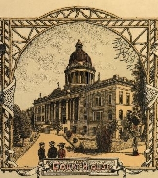
An early drawing of the old 1885 Fresno County
Courthouse taken from the border of a 1911 map of Fresno, California
572:
If the file has been modified from its original state, some details may not fully reflect the modified file.
517:
512:
37:
300:
558:
536:
304:
86:
308:
266:
8:
265:
occurred prior to
January 1, 1929, and if not then due to lack of notice or renewal. See
553:
535:== {{int:filedesc}} == {{Information |Description = An early drawing of the old 1885
135:
261:. This applies to U.S. works where the copyright has expired, often because its first
73:
342:
258:
253:
607:
175:
528:
262:
459:
421:
383:
581:
485:
Click on a date/time to view the file as it appeared at that time.
114:
36° 44′ 11.04″ N, 119° 47′ 20.76″ W
121:
61:
336:
Add a one-line explanation of what this file represents
547:
483:
85:
Commons is a freely licensed media file repository.
165:
51:(325 × 366 pixels, file size: 139 KB, MIME type:
66:
192:
161:
150:
181:
171:
14:
608:http://www.hmdb.org/marker.asp?marker=27940
176:http://www.hmdb.org/marker.asp?marker=27940
128:View this and other nearby images on:
549:The following 2 pages use this file:
276:
240:
97:
235:
104:
476:
153:Fresno County Courthouse (1885).jpg
47:Fresno_County_Courthouse_(1885).jpg
13:
591:Fresno County Courthouse rendering
567:
341:
335:
298:
287:
275:
249:
239:
98:
44:
621:
582:http://www.hmdb.org/copyright.asp
574:
340:
326:
134:
120:
65:
21:
323:
41:No higher resolution available.
480:
322:
26:
1:
412:coordinates of depicted place
402:coordinates of depicted place
31:
544:
348:Items portrayed in this file
211:
7:
564:
427:36°44'11.0"N, 119°47'20.8"W
10:
626:
251:This media file is in the
147:
100:
477:
16:
559:Fresno County Courthouse
537:Fresno County Courthouse
325:
301:rule of the shorter term
269:for further explanation.
72:This is a file from the
36:
534:
305:Knowledge:Public domain
164:
76:. Information from its
599:HMdb.org PhotoID=97980
513:11:46, 21 October 2012
292:
281:
245:
140:36.736400; -119.789100
79:description page there
291:
279:
243:
309:Knowledge:Copyrights
554:Fresno, California
293:
282:
246:
613:
612:
542:
334:
320:
319:
313:
311:for more details.
234:
233:
208:
207:
201:
198:Reusing this file
145:
144:
94:
93:
74:Wikimedia Commons
617:
578:Copyright holder
575:
525:
487:
332:
314:
297:
290:
278:
242:
236:
230:
227:
224:
221:
216:
215:
195:
188:
167:
154:
148:
141:
138:
124:
123:
117:
116:
105:
90:
69:
68:
62:
56:
54:
625:
624:
620:
619:
618:
616:
615:
614:
596:Credit/Provider
563:
543:
531:
523:
479:
478:
475:
474:
473:
472:
471:
470:
469:
468:
466:
456:
455:
454:
452:
437:
436:
435:
434:
433:
432:
431:
430:
428:
418:
417:
416:
414:
399:
398:
397:
396:
395:
394:
393:
392:
390:
380:
379:
378:
376:
361:
360:
359:
358:
357:
355:
339:
338:
337:
312:
296:
288:
271:
228:
225:
222:
219:
214:
209:
186:
152:
139:
112:
111:
108:Object location
103:
96:
95:
84:
83:
82:is shown below.
58:
52:
50:
43:
42:
12:
11:
5:
623:
611:
610:
605:
601:
600:
597:
593:
592:
589:
585:
584:
579:
566:
562:
561:
556:
546:
541:
540:
533:
529:
526:
520:
515:
510:
506:
505:
502:
499:
496:
493:
490:
482:
467:
464:
462:
461:
460:
458:
457:
453:
448:
446:
445:
444:
443:
441:
429:
426:
424:
423:
422:
420:
419:
415:
410:
408:
407:
406:
405:
403:
391:
388:
386:
385:
384:
382:
381:
377:
372:
370:
369:
368:
367:
365:
356:
351:
349:
346:
345:
344:
343:
331:
330:
327:
324:
318:
317:
315:
294:
284:
283:
273:
247:
232:
231:
213:
210:
206:
205:
202:
190:
189:
187:Unknown author
185:Unknown author
183:
179:
178:
173:
169:
168:
163:
159:
158:
155:
146:
143:
142:
132:
126:
109:
102:
99:
92:
91:
70:
60:
59:
40:
35:
34:
29:
24:
19:
9:
6:
4:
3:
2:
622:
609:
606:
603:
602:
598:
595:
594:
590:
587:
586:
583:
580:
577:
576:
573:
570:
560:
557:
555:
552:
551:
550:
538:
532:
527:
521:
519:
516:
514:
511:
508:
507:
503:
500:
497:
494:
491:
489:
488:
486:
463:
451:
447:
425:
413:
409:
387:
375:
371:
354:
350:
347:
328:
321:
316:
310:
306:
302:
295:
286:
285:
280:United States
274:
272:
270:
268:
264:
260:
259:United States
256:
255:
254:public domain
248:
244:Public domain
238:
237:
223:Public domain
220:Public domain
218:
217:
203:
199:
194:
191:
184:
180:
177:
174:
170:
160:
156:
149:
137:
133:
131:
130:OpenStreetMap
127:
125:
115:
110:
107:
106:
88:
81:
80:
75:
71:
64:
63:
57:
48:
39:
33:
30:
28:
25:
23:
20:
18:
15:
571:
568:
548:
484:
481:File history
252:
250:
87:You can help
77:
45:
22:File history
588:Image title
263:publication
151:Description
545:File usage
522:325 × 366
498:Dimensions
465:image/jpeg
450:media type
440:media type
193:Permission
53:image/jpeg
27:File usage
495:Thumbnail
492:Date/Time
374:inception
364:inception
267:this page
212:Licensing
565:Metadata
530:Emerson7
524:(139 KB)
329:Captions
32:Metadata
509:current
504:Comment
353:depicts
333:English
257:in the
101:Summary
49:
604:Source
204:pd old
182:Author
172:Source
118:
229:false
226:false
501:User
389:1911
307:and
166:1911
162:Date
17:File
200:)
196:(
89:.
55:)

.jpg)
.jpg¶ms=036.736400_N_-119.789100_E_globe:Earth_class:object_type:object__&language=en)