43:
284:
381:
290:
295:
174:
99:
593:"}},"text\/plain":{"en":{"":"copyright license"}}},"{\"value\":{\"entity-type\":\"item\",\"numeric-id\":14946043,\"id\":\"Q14946043\"},\"type\":\"wikibase-entityid\"}":{"text\/html":{"en":{"P275":"
549:"}},"text\/plain":{"en":{"":"copyright status"}}},"{\"value\":{\"entity-type\":\"item\",\"numeric-id\":50423863,\"id\":\"Q50423863\"},\"type\":\"wikibase-entityid\"}":{"text\/html":{"en":{"P6216":"
545:
342:– You must give appropriate credit, provide a link to the license, and indicate if changes were made. You may do so in any reasonable manner, but not in any way that suggests the licensor endorses you or your use.
465:
159:
400:
The ODbL does not require any particular license for maps produced from ODbL data. Prior to 1 August 2020, map tiles produced by the OpenStreetMap
Foundation were licensed under the
594:
550:
546:
590:
816:
597:"}},"text\/plain":{"en":{"P275":"Creative Commons Attribution-ShareAlike 3.0 Unported"}}}}": -->
73:
69:
65:
164:
This map may be incomplete, and may contain errors. Don't rely solely on it for navigation. In particular, note that this map overlays a
61:
57:
53:
47:
273:
110:
82:
620:
576:
1042:
This file contains additional information, probably added from the digital camera or scanner used to create or digitize it.
349:
806:
721:
716:
560:
786:
766:
711:
889:
604:
535:
791:
811:
796:
165:
305:
230:
1045:
If the file has been modified from its original state, some details may not fully reflect the modified file.
801:
756:
464:
348:– If you remix, transform, or build upon the material, you must distribute your contributions under the
553:"}},"text\/plain":{"en":{"P6216":"copyrighted"}}}}": -->
859:
118:
944:
821:
751:
234:
776:
674:
669:
42:
158:
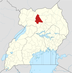
in Uganda, showing district boundaries as they stood in June 2017. For other districts, see
1004:
771:
302:
8:
909:
261:
105:
525:
488:
401:
224:
217:
974:
939:
781:
761:
393:
257:
155:
685:
183:
1024:
984:
879:
746:
741:
736:
726:
614:
570:
919:
706:
380:
240:
United States
National Imagery and Mapping Agency data (public domain)
160:
Category:SVG locator maps of
Districts in Uganda (location map scheme)
187:
168:
on an equirectangular projection; it is far from technically perfect.
375:
1014:
642:
Click on a date/time to view the file as it appeared at that time.
404:. Maps produced by other people may be subject to other licences.
389:
216:
Own work (hereby released by a CC-BY-SA-3.0 unported license <
223:
OpenStreetMap tiles (available under a CC-BY-SA-2.0 license <
173:
929:
313:© OpenStreetMap contributors, Jarry1250, NordNordWest/Wikipedia
849:
87:(SVG file, nominally 1,441 × 1,466 pixels, file size: 367 KB)
954:
869:
731:
235:
https://creativecommons.org/licenses/by-sa/3.0/de/legalcode
1029:
964:
839:
899:
237:> with attribution NordNordWest/Wikipedia) which uses
201:
93:
519:
Add a one-line explanation of what this file represents
497:
If inappropriate please set warp_status = skip to hide.
439:
994:
700:
431:
830:
640:
621:
Creative
Commons Attribution-ShareAlike 3.0 Unported
595:
Creative
Commons Attribution-ShareAlike 3.0 Unported
117:
Commons is a freely licensed media file repository.
483:
227:> with attribution © OpenStreetMap contributors)
447:
817:Knowledge:WikiProject Uganda/District templates
233:(available under a CC-BY-SA-3.0-de license <
225:https://creativecommons.org/licenses/by-sa/2.0/
218:https://creativecommons.org/licenses/by-sa/3.0/
359:https://creativecommons.org/licenses/by-sa/3.0
98:
413:http://opendatacommons.org/licenses/odbl/1.0/
365:Creative Commons Attribution-Share Alike 3.0
283:
268:
197:
140:
251:
207:
14:
325:– to copy, distribute and transmit the work
46:Size of this PNG preview of this SVG file:
137:
832:The following other wikis use this file:
491:Georeference the map in Wikimaps Warper
243:World Data Base II data (public domain)
702:The following 24 pages use this file:
129:
975:Mtumiaji:GerardM/Districts of Uganda
392:, which is made available under the
388:This work contains information from
306:Attribution-Share Alike 3.0 Unported
166:spherical pseudo-mercator projection
910:Ọbanife:GerardM/Districts of Uganda
807:University of the Sacred Heart Gulu
722:Achwa 3 Hydroelectric Power Station
717:Achwa 2 Hydroelectric Power Station
633:
294:
289:
13:
1040:
1011:Usage on zh-min-nan.wikipedia.org
787:Roman Catholic Archdiocese of Gulu
767:Gulu University School of Medicine
524:
518:
280:
220:> with attribution "Jarry1250")
178:
148:
130:
80:
1074:
1047:
1005:Oníṣe:GerardM/Districts of Uganda
792:Sir Samuel Baker Secondary School
523:
1025:User:GerardM/Districts of Uganda
985:User:GerardM/Districts of Uganda
880:User:GerardM/Districts of Uganda
812:User:GerardM/Districts of Uganda
797:St. Joseph's College Layibi
509:
463:
379:
336:Under the following conditions:
301:This file is licensed under the
293:
288:
282:
172:
97:
31:
21:
506:
149:
827:
802:St. Mary's Hospital Lacor
637:
505:
26:
1:
489:
36:
697:
531:Items portrayed in this file
394:Open Database License (ODbL)
378:
256:OpenStreetMap contributors,
231:File:Uganda location map.svg
7:
1037:
757:Gulu Regional Cancer Centre
143:Gulu District in Uganda.svg
10:
1079:
1021:Usage on zu.wikipedia.org
1001:Usage on yo.wikipedia.org
991:Usage on www.wikidata.org
981:Usage on ts.wikipedia.org
971:Usage on sw.wikipedia.org
961:Usage on pl.wikipedia.org
951:Usage on nl.wikipedia.org
936:Usage on ml.wikipedia.org
926:Usage on lg.wikipedia.org
916:Usage on ja.wikipedia.org
906:Usage on ig.wikipedia.org
896:Usage on id.wikipedia.org
886:Usage on he.wikipedia.org
876:Usage on ha.wikipedia.org
866:Usage on fr.wikipedia.org
856:Usage on fa.wikipedia.org
846:Usage on es.wikipedia.org
836:Usage on de.wikipedia.org
712:Acholibur–Gulu–Olwiyo Road
451:
350:same or compatible license
132:
634:
474:
454:
426:
16:
508:
440:Spatial reference system
316:
104:This is a file from the
41:
691:
108:. Information from its
822:Template:Gulu District
752:Gulu Military Hospital
427: Geotemporal data
111:description page there
435:Gulu District, Uganda
407:Open Database License
402:CC-BY-SA-2.0 license
74:1,441 × 1,466 pixels
70:2,013 × 2,048 pixels
66:1,007 × 1,024 pixels
670:20:58, 25 June 2017
331:– to adapt the work
52:Other resolutions:
945:ഫലകം:Gulu District
930:Gulu (disitulikit)
1066:
1065:
828:Global file usage
777:Kamdini–Gulu Road
695:
605:copyright license
591:copyright license
517:
502:
501:
498:
479:
478:
422:
421:
405:
277:
274:Reusing this file
186:was created with
169:
126:
125:
106:Wikimedia Commons
32:Global file usage
1070:
1048:
850:Distrito de Gulu
772:Gulu–Nimule Road
682:
644:
561:copyright status
547:copyright status
515:
496:
495:
493:
492:
467:
452:
417:
414:
411:
408:
399:
383:
376:
372:
369:
366:
363:
360:
352:as the original.
314:
303:Creative Commons
297:
296:
292:
291:
286:
285:
271:
203:
176:
163:
154:The location of
153:
144:
138:
122:
101:
100:
94:
88:
77:
62:755 × 768 pixels
58:472 × 480 pixels
54:236 × 240 pixels
48:589 × 599 pixels
1078:
1077:
1073:
1072:
1071:
1069:
1068:
1067:
1036:
955:Gulu (district)
870:Gulu (district)
826:
782:Paranga, Uganda
762:Gulu University
696:
688:
680:
636:
635:
632:
631:
630:
629:
628:
627:
626:
625:
623:
611:
610:
609:
607:
588:
587:
586:
585:
584:
583:
582:
581:
579:
567:
566:
565:
563:
544:
543:
542:
541:
540:
538:
522:
521:
520:
503:
490:
487:
443:equirectangular
415:
412:
409:
406:
374:
373:
370:
367:
364:
361:
358:
357:
315:
312:
309:
298:
264:
212:Derivative of:
193:
192:
191:
181:W3C-unspecified
170:
142:
135:
128:
127:
116:
115:
114:is shown below.
90:
86:
79:
78:
51:
12:
11:
5:
1076:
1064:
1063:
1060:
1056:
1055:
1052:
1039:
1035:
1034:
1033:
1032:
1027:
1019:
1018:
1017:
1009:
1008:
1007:
999:
998:
997:
989:
988:
987:
979:
978:
977:
969:
968:
967:
959:
958:
957:
949:
948:
947:
942:
934:
933:
932:
924:
923:
922:
914:
913:
912:
904:
903:
902:
894:
893:
892:
884:
883:
882:
874:
873:
872:
864:
863:
862:
854:
853:
852:
844:
843:
842:
829:
825:
824:
819:
814:
809:
804:
799:
794:
789:
784:
779:
774:
769:
764:
759:
754:
749:
744:
739:
734:
729:
724:
719:
714:
709:
699:
694:
693:
692:pattypan 17.05
690:
686:
683:
679:1,441 × 1,466
677:
672:
667:
663:
662:
659:
656:
653:
650:
647:
639:
624:
619:
617:
616:
615:
613:
612:
608:
603:
601:
600:
599:
598:
596:
592:
580:
575:
573:
572:
571:
569:
568:
564:
559:
557:
556:
555:
554:
552:
548:
539:
534:
532:
529:
528:
527:
526:
514:
513:
510:
507:
500:
499:
485:
484:Georeferencing
481:
480:
477:
476:
472:
471:
468:
461:
457:
456:
449:
445:
444:
441:
437:
436:
433:
429:
428:
424:
423:
420:
419:
386:
384:
356:
355:
354:
353:
343:
334:
333:
332:
326:
319:You are free:
310:
300:
299:
281:
278:
266:
265:
255:
253:
249:
248:
247:
246:
245:
244:
241:
228:
221:
209:
205:
204:
199:
195:
194:
171:
147:
145:
136:
134:
131:
124:
123:
102:
92:
91:
45:
40:
39:
34:
29:
24:
19:
9:
6:
4:
3:
2:
1075:
1061:
1058:
1057:
1053:
1050:
1049:
1046:
1043:
1031:
1030:Gulu District
1028:
1026:
1023:
1022:
1020:
1016:
1013:
1012:
1010:
1006:
1003:
1002:
1000:
996:
993:
992:
990:
986:
983:
982:
980:
976:
973:
972:
970:
966:
965:Dystrykt Gulu
963:
962:
960:
956:
953:
952:
950:
946:
943:
941:
938:
937:
935:
931:
928:
927:
925:
921:
918:
917:
915:
911:
908:
907:
905:
901:
898:
897:
895:
891:
890:מחוזות אוגנדה
888:
887:
885:
881:
878:
877:
875:
871:
868:
867:
865:
861:
858:
857:
855:
851:
848:
847:
845:
841:
840:Distrikt Gulu
838:
837:
835:
834:
833:
823:
820:
818:
815:
813:
810:
808:
805:
803:
800:
798:
795:
793:
790:
788:
785:
783:
780:
778:
775:
773:
770:
768:
765:
763:
760:
758:
755:
753:
750:
748:
747:Gulu Hospital
745:
743:
742:Gulu District
740:
738:
735:
733:
730:
728:
725:
723:
720:
718:
715:
713:
710:
708:
705:
704:
703:
689:
684:
678:
676:
673:
671:
668:
665:
664:
660:
657:
654:
651:
648:
646:
645:
643:
622:
618:
606:
602:
578:
574:
562:
558:
537:
533:
530:
511:
504:
494:
486:
482:
473:
469:
466:
462:
459:
458:
453:
450:
446:
442:
438:
434:
430:
425:
418:
403:
397:
395:
391:
390:OpenStreetMap
387:
385:
382:
377:
362:CC BY-SA 3.0
351:
347:
344:
341:
338:
337:
335:
330:
327:
324:
321:
320:
318:
317:
311:Attribution:
307:
304:
287:
279:
275:
270:
267:
263:
259:
254:
250:
242:
239:
238:
236:
232:
229:
226:
222:
219:
215:
214:
213:
210:
206:
200:
196:
189:
185:
182:
175:
167:
161:
157:
156:Gulu District
152:
146:
139:
120:
113:
112:
107:
103:
96:
95:
89:
84:
83:Original file
75:
71:
67:
63:
59:
55:
49:
44:
38:
35:
33:
30:
28:
25:
23:
20:
18:
15:
1044:
1041:
900:Distrik Gulu
831:
737:Gulu Airport
727:Bobi, Uganda
701:
641:
638:File history
448:Bounding box
432:Map location
398:
345:
339:
328:
322:
262:NordNordWest
211:
202:25 June 2017
184:vector image
180:
150:
119:You can help
109:
81:
22:File history
577:copyrighted
551:copyrighted
346:share alike
340:attribution
141:Description
860:ناحیه گولو
707:Acholi Inn
698:File usage
655:Dimensions
269:Permission
27:File usage
1015:Gulu Koān
687:Jarry1250
652:Thumbnail
649:Date/Time
470:E: 35.3°E
460:W: 29.2°E
258:Jarry1250
151:English:
1038:Metadata
995:Q1028215
681:(367 KB)
512:Captions
475:S: 1.7°S
455:N: 4.5°N
329:to remix
323:to share
308:license.
188:Inkscape
37:Metadata
666:current
661:Comment
536:depicts
516:English
252:Creator
133:Summary
85:
1062:1466.1
1059:Height
1054:1440.9
208:Source
177:
1051:Width
179:This
940:ഗുലു
732:Gulu
658:User
416:true
410:ODbL
371:true
368:true
198:Date
17:File
920:グル県
396:.
260:,
162:.
72:|
68:|
64:|
60:|
56:|
50:.
276:)
272:(
190:.
121:.
76:.
Text is available under the Creative Commons Attribution-ShareAlike License. Additional terms may apply.
